Related Research Articles

Des Moines is the capital and the most populous city in Iowa, United States. It is also the county seat of Polk County. A small part of the city extends into Warren County. It was incorporated on September 22, 1851, as Fort Des Moines, which was shortened to "Des Moines" in 1857. It is located on, and named after, the Des Moines River, which likely was adapted from the early French name, Rivière des Moines, meaning "River of the Monks". The city's population was 214,133 as of the 2020 census. The six-county metropolitan area is ranked 83rd in terms of population in the United States with 699,292 residents according to the 2019 estimate by the United States Census Bureau, and is the largest metropolitan area fully located within the state.

Waterloo is a city in and the county seat of Black Hawk County, Iowa, United States. As of the 2020 United States Census the population was 67,314, making it the eighth-largest city in the state.

Effigy Mounds National Monument preserves more than 200 prehistoric mounds built by pre-Columbian Mound Builder cultures, mostly in the first millennium CE, during the later part of the Woodland period of pre-Columbian North America. Numerous effigy mounds are shaped like animals, including bears and birds.

Dubuque County is a county located in the U.S. state of Iowa. As of the 2020 census, the population was 99,266, making it the eighth-most populous county in Iowa. The county seat is Dubuque. The county is named for Julien Dubuque, the first European settler of Iowa.

Story City is a city in Story County, Iowa. It is located within the Ames, Iowa Metropolitan Statistical Area which envelops the entirety of Story County and combined with the Boone, Iowa Micropolitan Statistical Area makes up the larger Ames-Boone, Iowa Combined Statistical Area. The population was 3,352 in the 2020 census, a slight increase from 3,228 in 2000.
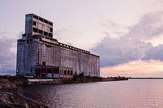
A grain elevator is a facility designed to stockpile or store grain. In the grain trade, the term "grain elevator" also describes a tower containing a bucket elevator or a pneumatic conveyor, which scoops up grain from a lower level and deposits it in a silo or other storage facility.

The Driftless Area, also known as Bluff Country, the Blufflands, the Paleozoic Plateau, and the Coulee Region, is a topographical and cultural region in the Midwestern United States that comprises southwestern Wisconsin, southeastern Minnesota, northeastern Iowa, and the extreme northwestern corner of Illinois. The Driftless Area is a USDA Level III Ecoregion: Ecoregion 52. The Driftless Area takes up a large portion of the Upper Midwest forest–savanna transition.

The Augusta Canal is a historic canal located in Augusta, Georgia, United States. The canal is fed by the Savannah River and passes through three levels in suburban and urban Augusta before the water returns to the river at various locations. It was devised to harness the water power at the fall line of the Savannah River to drive mills, to provide transportation of goods, and to provide a municipal water supply. It is the only canal in the US in continuous use for its original purposes of providing power, transport, and municipal water.

Central Illinois is a region of the U.S. state of Illinois that consists of the entire central third of the state, divided from north to south. Also known as the Heart of Illinois, it is characterized by small towns and mid-sized cities. Agriculture, particularly corn and soybeans, as well as educational institutions and manufacturing centers, figure prominently.
Freedom's Frontier National Heritage Area, Inc. (FFNHA) is a federally designated U.S. National Heritage Area located in eastern Kansas and Western Missouri. This heritage area preserves, conserves, and interprets historic and cultural landscapes pertaining to: the shaping of the frontier, the Missouri-Kansas Border War, and the enduring struggle for freedom. FFNHA was authorized on October 12, 2006, with the passage of the National Heritage Areas Act of 2006. The management plan for the heritage area was approved by the Board of Trustees on June 10, 2009, and undergoes official review by the National Park Service to ensure it complies with all components required within the enabling legislation.

The Mines of Spain State Recreation Area and E. B. Lyons Nature Center is a state park in Dubuque County, Iowa, United States. It is near Dubuque, the eleventh-largest city in the state. The park features picnic areas, 15 miles (24 km) of walking/hiking trails, 4 miles (6.4 km) of ski trails, and the Betty Hauptli Bird and Butterfly Garden. It also includes archaeological sites of national importance as an early lead mining and smelting venture led by French explorer Julien Dubuque, as well as Dubuque's gravesite. These sites were collectively designated a National Historic Landmark District as Julien Dubuque's Mines.

Hartman Reserve Nature Center is a 308.9-acre (1.250 km2) nature reserve located in Cedar Falls, Iowa. The reserve is dedicated to teaching youth about nature through hands on experiences and preservation. It is the largest undisturbed wooded area in Black Hawk County, Iowa and is home to three distinct habitats including wetland, forest, and prairie.

Iowa is a state in the upper Midwestern region of the United States, bordered by the Mississippi River to the east and the Missouri River and Big Sioux River to the west. It is bordered by six states: Wisconsin to the northeast, Illinois to the east and southeast, Missouri to the south, Nebraska to the west, South Dakota to the northwest, and Minnesota to the north.

The Trail of the Ancients is a collection of National Scenic Byways located in the U.S. Four Corners states of Utah, Colorado, New Mexico, and Arizona. These byways comprise:
Motor is an unincorporated community in Clayton County, Iowa, United States. The townsite is also a nationally recognized historic district listed as a historic site on the National Register of Historic Places in 1977.

Hurstville Historic District is a nationally recognized historic district located north of Maquoketa, Iowa, United States. It was listed on the National Register of Historic Places in 1979. At the time of its nomination it included three areas: the former lime manufacturing works, a farmstead, and the townsite. All that remains are the four kilns, and an old warehouse. Both the townsite, which was across the road and to the southwest, and the farmstead, which was behind the kilns to the south, are gone. Also gone are the remaining company buildings, with the exception of the old warehouse, which were across the road to the west. The houses in the townsite were side-gable cottages. Many lacked indoor plumbing into the 1970s and were vacant. The farmstead included 20 structures devoted to domestic or agricultural use. Two large barns were the most notable structures. The farm served the needs of the town. The most significant structures in the district were the lime kilns.

Painter-Bernatz Mill, also known as the Old Stone Mill, is a historic building located in Decorah, Iowa, United States. The original part of the mill was constructed by William Painter in 1851, and it was expanded to its present size in the next year or two. A mill race was constructed from a dam on the Upper Iowa River, and it was routed beneath the building to power the turbine. It was the first of at least 15 mills that used this river as its source of power. The lower two floors are composed of native limestone. The original hip roof was removed sometime between 1874 and 1890 and the present gable roof was built giving the mill a large loft. Diesel power replaced water power in 1947. The building continued to operate as a mill until 1964. It became a part of the Vesterheim Norwegian-American Museum in 1971, and houses exhibits on agriculture and industry. It is also a site in the Silos & Smokestacks National Heritage Area. The former mill is the oldest building in Decorah. It was listed on the National Register of Historic Places in 1974.
Tyden Farm No. 6 Farmstead Historic District is an agricultural historic district located east of Dougherty, Iowa, United States. It was listed on the National Register of Historic Places in 2009.

Four Mounds Estate Historic District is a nationally recognized historic district located in Dubuque, Iowa, United States. It was listed on the National Register of Historic Places in 2002. At the time of its nomination the district consisted of 19 resources, including 11 contributing buildings, two contributing sites, four non-contributing structures, and two non-contributing buildings. The estate is named for the four conical burial mounds that are located on the property. They are one of the historic sites, and they are individually listed on the National Register of Historic Places.
References
- 1 2 "Silos & Smokestacks National Heritage Area : About Us" . Retrieved November 28, 2011.
- ↑ "Silos and Smokestacks National Heritage Area (U.S. National Park Service)" . Retrieved November 28, 2011.
- ↑ "Silos & Smokestacks National Heritage Area" . Retrieved November 28, 2011.