SPC day 1 convective outlook for April 1,2024 at 20Z
On March28,the Storm Prediction Center (SPC) first delineated a risk of organized severe weather across the Central and Southern Plains,as well as the Mississippi and Ohio River valleys for the beginning of April.[9] By the morning of April1,a broad category 3/Enhanced risk existed from north-central Texas northeastward toward the Illinois–Indiana border,where widespread supercell thunderstorms were anticipated. The impetus for the severe weather setup came as a large,positively tilted upper-level trough progressed eastward from the Southwestern United States into the Central Plains region.[10] Morning surface observations revealed an area of low pressure over central Kansas,supporting a north-moving warm front to the east into Ohio and a trailing cold front southwestward into Oklahoma and the Texas Panhandle. Meanwhile,an eastward-shifting dry line resided from the Texas Panhandle southward into northern Mexico.[11] Within the warm sector of this low,an unstable environment was expected to develop,with averaged instability values of 2,000–3,000J/kg,dewpoints in the mid- to upper-60s °F,very strong wind shear throughout the atmosphere,and rapidly cooling temperatures with height. Given these conditions,the SPC upgraded much of the eastern half of Oklahoma and a small section of northern Texas to a category 4/Moderate risk. In this area,the capping inversion aloft was expected to erode throughout the afternoon,giving way to multiple supercells capable of producing large hail in excess of 3in (7.6cm). A conditional threat of strong/EF2+ tornadoes existed too as wind shear close to the surface strengthened with time.[12]
Derecho
SPC day 1 convective outlook for April 2,2024
Through the afternoon hours,semi-discrete supercells developed across north and central Texas,contributing to widespread reports of large hail the size of baseballs,in addition to hurricane-force wind gusts upwards of 90mph (140km/h).[13] Farther to the northeast,isolated severe weather occurred in Oklahoma,though it was curtailed by persistent cloud cover and a broad rain shield across the risk area.[14] Even farther to the northeast,training supercell thunderstorms tracked across the St. Louis metropolitan area,contributing to large hail.[15] By the evening hours,a quasi-linear convective system developed across eastern Oklahoma and progressed toward Missouri and Illinois. As it did so,the squall line interacted with boundaries produced by earlier storms;this resulted in several tornadic circulations along the line.[16] In spite of modest instability,strong vertical wind shear maintained organized convective activity as it spread eastward from southern Illinois and eventually into West Virginia during the pre-dawn and early morning hours.[17][18] Numerous reports of damaging winds were received,including gusts in excess of 90mph (140km/h) near Huntington,West Virginia.[19] The squall line posthumously met the criteria of a derecho,and post-storm surveys revealed dozens of tornadoes along its track. In particular,10 tornadoes were confirmed across West Virginia on April2,the most observed in a single calendar day on record.[5] Convective activity finally lost vigor as it moved toward the West Virginia–Virginia border into a more stable environment.[20]
As the derecho tracked from Missouri to West Virginia early on April2,another widespread outbreak of severe weather and tornadoes was expected to occur across the broader Ohio River Valley region. On April1,the SPC issued a category 4/Moderate risk across much of Ohio and adjacent portions of surrounding states. Despite questions about the influence of widespread morning thunderstorms,forecasters felt there was sufficient confidence that the atmosphere would recover over subsequent hours,contributing to discrete or clusters of storms capable of producing damaging winds,large hail,and multiple significant tornadoes.[21] By the afternoon hours of April2,forecasters expressed concern that morning convection would stunt the degree of destabilization across portions of the risk area,particularly in Ohio. Farther to the west,an environment characterized by surface temperatures of in the low- to mid-70s °F,dewpoints between 65–70°F (18–21°C),and strong vertical wind shear was still expected to promote a substantiative risk for strong tornadoes.[22] Storms across southern Indiana and western Kentucky initially struggled to intensify during the afternoon,[23] but they eventually matured into tornado-producing supercells as they continued eastward into western Ohio.[24] As convective activity to the north continued eastward into a drier and more stable environment,[25] a cluster of storms developed farther south across Alabama and Georgia,contributing to additional tornadoes.[26][27] Into April3,additional severe weather occurred along frontal boundaries from Florida to Virginia before activity pushed offshore.[28][29]
A high-end EF0 tornado caused minor roof and siding damage to homes, blew down part of a fence, and damaged trees, including some that were snapped or uprooted.[30][31]
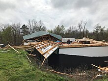
A large, high-end EF1 tornado formed almost immediately after the previous tornado dissipated. It blew the roof off of a garage, uprooted or snapped trees, and blew down numerous power poles.[32][33]
A tornado uprooted and/or snapped over 200 trees, rolled an unanchored mobile home, damaged the roof of a residence, and damaged multiple outbuildings.[35]
A brief, weak tornado damaged small outbuildings at an elementary school as well as to a light pole at a football stadium. A school camera captured the tornado moving over a school building.[38]
A twin tornado developed to the south of the previous tornado. The roofs of two homes were damaged, an outbuilding was destroyed, and trees were uprooted.[32][33]
This tornado began along IL 148 and crossed over I-57 heading east, causing roof damage to homes and outbuildings, and snapping or uprooting trees. The tornado reached its peak intensity of high-end EF2 along the north side of the Lake of Egypt, causing severe roof and structural damage to three businesses, and blowing out a window at the nearby fire protection building. The tornado continued to damage homes and outbuildings and snapped or uprooted numerous trees before dissipating.[39][40][42]
Along the beginning of this tornado path, many trees were snapped or uprooted. Moving eastward, the tornado reached its peak intensity of high-end EF1 as it moved directly through Stonefort. A couple of homes had portions of their roofs ripped off; however, the majority of houses were damaged by fallen trees. Outbuildings and a mobile home also had roof damage in the town. The tornado continued to snap and uproot trees east of the town before dissipating.[40][42]
A house had a portion of its roof removed, a couple of other homes suffered fascia and siding damage, and about a dozen trees had large limbs downed.[40][43]
A strong tornado destroyed an outbuilding and removed portions of roofing from two homes. An industrial garage and two manufactured homes were severely damaged. One manufactured home was moved several feet off its foundation and had one of its walls torn open, resulting in injury to two occupants. Multiple trees were snapped or uprooted.[39][40][42]
Several large trees were snapped or uprooted, one of which crushed a small brick building. A manufactured home was severely damaged and a nearby outbuilding had part of its roof ripped off.[39][40][42]
A brief tornado caused significant roof damage to a couple of a large farm outbuildings; debris was tossed hundreds of feet. A home sustained shingle damage and several trees were snapped or uprooted.[40][44]
This EF2 tornado snapped or uprooted hundreds of trees. Several outbuildings and sheds were damaged or destroyed. Several homes sustained minor to moderate roof damage. This tornado eventually merged with the 10:37 UTC tornado.[39][40][45]
A strong tornado snapped or uprooted hundreds of trees and damaged or destroyed dozens of outbuildings. Several homes sustained minor to moderate damage. This tornado merged with the 10:31 UTC tornado.[39][40][46]
A large, newly built farm outbuilding sustained severe roof and wall damage. A home sustained shingle and fascia damage, a shed was destroyed, and a carport was damaged. Several trees were damaged as well.[40][44]
A large farm outbuilding was severely damaged, two homes sustained roof damage, and several large trees were snapped at their base. One tree fell on a manufactured home, resulting in injury to a resident.[40][44]
A strong tornado completely ripped the roofs off several homes. Additional but more minor damage occurred to a few other homes as well. Numerous outbuildings or sheds were damaged or destroyed. Hundreds of trees were snapped or uprooted.[40][47]
A significant tornado damaged or destroyed dozens of outbuildings, damaged several homes, and snapped electrical power poles. Hundreds of trees were also snapped or uprooted.[39][40]
Dozens of trees were snapped or uprooted and several outbuildings were damaged or destroyed. A few homes sustained minor to moderate damage. This tornado merged with the 10:48 UTC EF2 tornado.[40][48]
A large barn was destroyed, and one home sustained significant shingle damage. A few other houses sustained minor damage as well. Dozens of trees were snapped or uprooted.[40][49]
A home had extensive roof damage while two nearby barns had large portions of their roofs removed. Another home had minor roof and exterior damage and trees were snapped or twisted.[51]
Multiple barns were significantly damaged or destroyed. A garage door was blown in, a home sustained broken windows, and multiple trees were downed.[51]
A very brief tornado tossed two storage sheds onto a highway. It continued into an industrial park, ripping off large portions of roofing, blowing out doors, and pulling away wall panels from many buildings and warehouses. Boards and drywall were impaled into the surrounding structures and the ground. Three vehicles were flipped over and a heavy travel trailer was moved about 20yd (18m).[51]
Three funnels consolidated into a tornado that impacted two farms. On one farm, multiple structures sustained damage. On the other property, an open-area structure was collapsed save for one remaining wall. An adjacent stable sustained roof damage and multiple trailers were flipped. Six horses were injured, a barn was demolished, and multiple large trees were downed, which likely caused damage to a stone cabin.[51]
A home sustained extensive roof damage and some structural damage. The southeast corner of a barn was blown out. Extensive tree damage occurred as well.[52]
The back half of the roofing structure of a manufactured home was lifted. Grass, mud, and insulation plastered the front of the home. This is the only damage caused by this very brief tornado.[52]
A high-end EF1 tornado began in Greenup beginning at a cemetery in town. The tornado tracked southeast, damaging the roofs of building and downing trees, some onto buildings. The tornado crossed the Ohio River into the town of Hanging Rock, where it impacted a campground. Several RV were overturned and tossed throughout the campgrounds. A salt storage dome was destroyed, causing one employee to get seriously injured. The tornado continued southeastward, damaging a few homes and the Ironton Middle School before weakening and dissipating. This was originally classified as a microburst before reanalysis determined it was a tornado.[39][5]
A single-wide trailer home was flipped, and a home was damaged and shifted off its foundation with other homes also receiving damage. This tornado was embedded within a larger area of damaging straight-line winds from the storm.[5]
This brief but strong tornado caused severe tree damage, destroyed several barns and outbuildings, and removed the roof from a house completely. Additional homes sustained damage.[39][5]
The roofs were blown off three structures, including two homes. Tin panels were uplifted on a barn roof as well. A few trees were knocked down. A travel trailer was rolled.[5]
A high-end EF1 tornado snapped or uprooted a significant amount of trees in the Wayne National Forest. This tornado path may be extended in later surveys.[5]
Several large hardwood trees were uprooted in a ravine. Some barns were damaged by fallen trees. The roof and exterior walls of a warehouse were blown off.[5]
An intermittent, low-end EF1 tornado did scattered tree damage, mainly downing large tree limbs with a few uprooted trees at first. Moving east, a narrow swath of uprooted and snapped trees resulted in the EF1 rating. The tornado continued east, crossing the Kanawha River before dissipating in Bancroft.[5]
An EF1 tornado snapped or uprooted a significant number of trees, many of which fell on and damaged homes. Another house had its roof blown off.[39][5]
This intermittent but strong low-end EF2 tornado traveled near the Putnam-Kanawha County line. Several large and healthy trees were snapped at their bases and uprooted. Minor damage to homes was noted in the area, too. The tornado traveled due east, continuing to snap and uproot trees. One of the trees fell onto a home, which significantly damaged the second story of the home. Before lifting, several additional large trees were either snapped and/or uprooted.[39][5]
A tornado began in the Kanawha State Forest and skipped along an intermittent path eastward. The top floor was blown off of one structure, an RV was rolled, and significant tree damage occurred. The tornado dissipated before reaching I-64.[5]
A tornado touched down multiple times, primarily inflicting damage to trees. One home had a portion of its roof decking ripped off and thrown. Roofing material and outdoor accessories were blown away as well. Another home also sustained damage to its gutter covers.[51]
A strong tornado touched down and immediately started causing considerable and significant tree damage, snapping and uprooting hundreds of trees. Several homes were damaged by trees, including one home that had significant roof damage. The tornado made a slight jog to the northeast where the tornado reached its peak intensity with significant tree damage. The tornado damaged or destroyed several homes, shifting one home several feet off its foundation and tossing the metal roof approximately 350yd (320m). The exact beginning and ending point of the tornado is unknown due to difficulties with access. The track may be revised if drone footage can be reviewed.[39][5]
A tornado touched down in downtown Sunbright and dealt damage to numerous residential and commercial structures. As the tornado tracked northeast, exiting the town, some metal building structures, barns, and trees in this area were damaged. The tornado re-intensified and damaged several more homes and barns before it dissipated. This tornado occurred almost exactly one year after a tornado struck Sunbright during an outbreak the previous year.[39][53]
This tornado began along I-265, where it knocked over three tractor trailers and uprooted some trees. The tornado quickly strengthened, moving through the neighborhood of Brookhollow in Jeffersonville. In Brookhollow, many garage doors were blown out, windows were broken, brick facade crumbled, trees were uprooted, and large sections of roofs were blown off structures. Many boards were impaled and driven more than a foot into the ground with others being impaled into homes. An industrial business along I-265 had a 5,000lb (2,300kg)salt pod was lifted up over a concrete barrier and thrown down a hill approximately 40yd (37m). The tornado broke windows and peeled metal roofing off of more homes before crossing the Ohio River into Kentucky. As it entered Kentucky, the tornado widened and briefly strengthened to EF2 intensity twice as it moved through Prospect. The Beechland Beach neighborhood had well-built homes suffer significant roof damage, broken windows, and air conditioner units twisted and torn from the sides of the homes. One home suffered a collapsed exterior wall. The tornado crossed a park and entered the neighborhood of The Sutherlands. Numerous homes suffered roof damage, power lines were downed, power poles were snapped, and trees were uprooted. A part of a tree was torn from the main trunk and impaled over four feet into the ground here. The tornado then entered the Hunting Creek neighborhood, where more trees were uprooted and more roof damage was dealt to homes, including two homes that suffered total roofing loss. The tornado exited Hunting Creek and weakened as it entered Hidden Creek. Trees were uprooted, barns took damage to their overhead doors and sheet metal, and some homes incurred roof damage. The tornado finally exited Prospect, turning northeast and striking the southern portion of a golf course, uprooting trees and damaging barns. The tornado then lifted northeast of the golf course. There were 22 injuries.[39][51]
An EF2 tornado impacted multiple homes, ripping off large portions of roofing, blowing out windows, and inverting or blowing out garage doors. The roof HVAC system at a high school was blown to the ground, and a nearby streetlight was bent. An adjacent metal warehouse sustained some roof damage and had its garage doors inverted. A large, open-faced metal RV storage building likewise sustained damage to its roof and walls. Numerous trees were snapped or uprooted as well.[39][51]
A tornado touched down in the southwesternmost corner of Ohio County before destroying a garage and a well-constructed barn. The tornado continued east through inaccessible areas, uprooting trees before lifting.[39][54]
A weak tornado developed north of Richmond where trees were broken off and uprooted at the start of the damage path. From there, the tornado traveled northeast across I-70 causing mainly tree damage along its path. After the tornado crossed the interstate, it widened briefly, damaging several barns, outbuildings, and residential structures. Several of the barns lost major portions of their roofs, trailers were tipped over, and a porch was damaged on a home. The tornado then continued over open fields before dissipating as it approached the Ohio-Indiana state line.[39][55]
A tornado touched down and immediately destroyed a poorly-anchored mobile home. Tree and outbuilding damage also occurred in the area before the tornado tracked northeast. The tornado removed the roof of a covered bridge. Several well-constructed outbuildings were damaged and multiple large trees were snapped nearby as the tornado reached its peak intensity. More trees were snapped and uprooted as the tornado continued northeast. The tornado then briefly entered Adams Lake State Park, where considerable tree damage occurred before the tornado lifted.[59]
Multiple small and large tree branches were snapped, a garage and a shed lost a significant amount of their metal roofing, and several large trees were uprooted.[39][56]
The tornado began at the Parr Airport, where it collapsed a hangar and shifted tied-down aircraft. The roof was lifted off a single-wide manufactured home; two barns and a frame home sustained roof damage as well. A small shed was destroyed. Numerous trees were snapped or uprooted.[61]
Numerous trees sustained damage and multiple homes and outbuildings were damaged. A car trailer was blown 100yd (91m) and destroyed, as well as a barn. An additional home sustained roof damage before the tornado dissipated.[62]
To the west of Conyers, this tornado snapped or uprooted numerous trees and damaged homes in multiple neighborhoods. A small area of low-end EF2 damage occurred in an area where a home had a large portion of its roof removed and a nearby power pole was snapped. After crossing I-20/US 278, the tornado moved through the northern part of Conyers, causing weaker but still significant damage to homes, vehicles, and businesses. The tornado then dissipated northeast of the town along SR 138. Two people were injured.[39][63]
A very brief tornado touched down in a small forested area in town, snapping a few trees and damaging power lines and poles. A few retail signs were damaged as well.[39][63]
A waterspout began over Lake Blackshear and moved ashore, damaging numerous trees on the lake. Several homes sustained significant damage due to falling trees and others were dealt roof damage. Two farm pivot-irrigation systems were flipped and a few more trees were snapped before the tornado lifted.[39][63]
A tornado demolished a storage shed and uprooted numerous trees as it touched down. The tornado quickly moved northeast through a golf course where additional trees and sheds were damaged. After exiting the golf course, two houses saw portions of their roofs peeled off. More roof damage on houses occurred and more trees were uprooted before the tornado lifted.[39][65]
Non-tornadic effects
Mid-sized hail that fell in Gahanna, Ohio on April 3
Heavy flooding in the Midwest was observed in the days leading up to the outbreak, mainly March 31. Many areas of Ohio, Kentucky, Indiana and West Virginia were put on flood watches and flash flood warnings.[66]Ground-to-cloud lightning was observed throughout the entire outbreak. In Carthage, Missouri, which is northeast of Joplin, straight-line wind damage was reported. Winds gusted up to 100mph (160km/h) during that event. Power poles were broken, and trees were snapped as a direct result of these storms. Ground scouring was also observed in parts of Central Oklahoma. In West Virginia, there were nearly 100 reports of straight-line wind damage along with the tornadoes. A wind gust of 92mph (148km/h) was recorded at Tri-State Airport in Huntington, West Virginia.[67]
Over 250,000 people were left without power in the wake of the storm; with many of those outages in West Virginia.[73] At around 4:10pm on April 2, the state of Kentucky issued a state of emergency.[74][75] West Virginia also declared a state of emergency for 21 counties.[76]
A map of the tornadoes and straight-line wind damage reports from April 2, 2024
The tornado outbreak was historic in West Virginia according to the National Weather Service. Their Charleston office stated that "The 17 confirmed tornadoes are the most tornadoes for any calendar day and event on record for the NWS Charleston County Warning Area. The previous record was 6 tornadoes on April 4, 1974. To further put this number into perspective, the previous record number of tornadoes for an entire calendar year over the NWS Charleston County Warning Area was 11 set in 1980, and it took 7 different days with tornadoes to reach that number."[5]
Ten tornadoes occurred in West Virginia; which also set a state record for the most tornadoes confirmed in a single day. The previous record was seven; set on both April 4, 1974 and June 2, 1998.[77]
The 2002 Veterans Day weekend tornado outbreak was an unusually severe and expansive severe weather event across portions of the Central and Eastern United States from the evening hours of November 9 into the early morning hours of Veterans Day, November 11, 2002. A series of troughs tracked eastward across the United States, providing strong wind shear, while anomalously warm and unstable air surged northward into the Ohio River Valley. As a result, multiple tornadoes occurred across Arkansas, Tennessee, and Missouri on November 9. A far more widespread and severe event occurred the following day, with three distinct tornado outbreaks focused across areas from Illinois to Pennsylvania; Tennessee and Kentucky; and areas from Mississippi to South Carolina. The most intense tornado of the outbreak was a violent F4 tornado that occurred near Van Wert, Ohio. A total of 76 tornadoes occurred during the 3-day period, collectively resulting in 36 deaths and 303 injuries. As of 2022, the event ranks as the third-largest tornado outbreak on record in November.
From May 3 to May 11, 2003, a prolonged and destructive series of tornado outbreaks affected much of the Great Plains and Eastern United States. Most of the severe activity was concentrated between May 4 and May 10, which saw more tornadoes than any other week-long span in recorded history; 335 tornadoes occurred during this period, concentrated in the Ozarks and central Mississippi River Valley. Additional tornadoes were produced by the same storm systems from May 3 to May 11, producing 363 tornadoes overall, of which 62 were significant. Six of the tornadoes were rated F4, and of these four occurred on May 4, the most prolific day of the tornado outbreak sequence; these were the outbreak's strongest tornadoes. Damage caused by the severe weather and associated flooding amounted to US$4.1 billion, making it the costliest U.S. tornado outbreak of the 2000s. A total of 50 deaths and 713 injuries were caused by the severe weather, with a majority caused by tornadoes; the deadliest tornado was an F4 that struck Madison and Henderson counties in Tennessee, killing 11. In 2023, tornado expert Thomas P. Grazulis created the outbreak intensity score (OIS) as a way to rank various tornado outbreaks. The tornado outbreak sequence of May 2003 received an OIS of 232, making it the fourth worst tornado outbreak in recorded history.
On November 17, 2013, the deadliest and costliest November tornado outbreak in Illinois history took shape, becoming the fourth-largest for the state overall. With more than 30 tornadoes in Indiana, it was that state's largest tornado outbreak for the month of November, and the second largest outbreak recorded in Indiana. Associated with a strong trough in the upper levels of the atmosphere, the event resulted in 77 tornadoes tracking across regions of the Midwest United States and Ohio River Valley, impacting seven states. Severe weather during the tornado outbreak caused over 100 injuries and eleven fatalities, of which eight were tornado related. Two tornadoes—both in Illinois and rated EF4 on the Enhanced Fujita scale—were the strongest documented during the outbreak and combined for five deaths. In addition to tornadoes, the system associated with the outbreak produced sizeable hail peaking at 4.00 in (10.2 cm) in diameter in Bloomington, Illinois, as well as damaging winds estimated as strong as 100 mph (160 km/h) in three locations.
This page documents notable tornadoes and tornado outbreaks worldwide in 2020. Strong and destructive tornadoes form most frequently in the United States, Argentina, Brazil, Bangladesh, and eastern India, but can occur almost anywhere under the right conditions. Tornadoes also develop occasionally in southern Canada during the Northern Hemisphere's summer and somewhat regularly at other times of the year across Europe, Asia, Argentina, Australia and New Zealand. Tornadic events are often accompanied by other forms of severe weather, including strong thunderstorms, strong winds, and hail. There were 1,243 preliminary filtered reported tornadoes in 2020 in the United States in 2020, and 1,086 confirmed tornadoes in the United States in 2020. Worldwide, at least 93 tornado-related deaths were confirmed with 78 in the United States, eight in Vietnam, two each in Canada, Indonesia, and Mexico, and one in South Africa.
The tornado outbreak of January 10–11, 2020 was a two-day severe weather event stretching from the South-Central Plains eastward into the Southeast United States. An eastward-moving shortwave trough tracked across the continental United States through that two-day period, combining with abundant moisture, instability, and wind shear to promote the formation of a long-lived squall line. Hundreds of damaging wind reports were received, and 80 tornadoes occurred within this line, making it the third largest January tornado outbreak on record. Three tornadoes—an EF1 in eastern Texas, an EF2 in northern Louisiana, and an EF2 in western Alabama—led to a total of seven deaths, all in mobile homes. There were five other storm related deaths, including two due to icy roads in Lubbock, Texas, one due to drowning in Oklahoma, and one due to icy roads in Iowa. The system also brought a monthly record high temperature to Boston and Bridgeport. Extensive damage and several other injuries occurred as well. The severe weather event was notable in that it was forecast well in advance, with the Storm Prediction Center first highlighting the risk area a full week beforehand. Total damage from the event reached $1.1 billion according to the National Centers for Environmental Information.
As Hurricane Isaias moved up the East Coast of the United States, a damaging outbreak of 39 tornadoes impacted areas from South Carolina to Connecticut between August 3–4, 2020. The most significant tornado of the outbreak was a large and intense EF3 tornado that obliterated a mobile home park near Windsor, North Carolina, killing two and injuring 14. This was the strongest tornado in the United States to be spawned by a tropical cyclone since 2005. In the end, the outbreak killed two and injured 26.
This page documents notable tornadoes and tornado outbreaks worldwide in 2021. Strong and destructive tornadoes form most frequently in the United States, Argentina, Brazil, Bangladesh, and Eastern India, but can occur almost anywhere under the right conditions. Tornadoes also develop occasionally in southern Canada during the Northern Hemisphere's summer and somewhat regularly at other times of the year across Europe, Asia, Argentina, Australia and New Zealand. Tornadic events are often accompanied by other forms of severe weather, including strong thunderstorms, strong winds, and hail. Worldwide, 150 tornado-related deaths were confirmed with 103 in the United States, 28 in China, six in the Czech Republic, four in Russia, three in Italy, two in India, and one each in Canada, New Zealand, Indonesia, and Turkey.
A significant early spring tornado outbreak occurred during the afternoon and evening hours of March 5, 2022 in the Midwest, primarily in the state of Iowa, before transitioning to a damaging wind event across northern parts of Illinois and Indiana. Multiple tornadoes were reported, several of which were produced by a dominant supercell thunderstorm in central Iowa. One long-track, low-end EF4 tornado caused major damage near the towns of Winterset and Norwalk, resulting in six fatalities. Multiple other supercells spawned along an area of moderate destabilization in northern Missouri, prompting further tornado warnings in southern Iowa, as they entered a highly favorable environment for maturing. Large hail and damaging wind gusts accompanied the storms, which continued their passage across the Midwestern states into overnight. More tornadic weather was confirmed in Arkansas and Missouri the next day and into the early morning of March 7. In addition to that, straight line winds killed one person near Hazel, Kentucky when a semi trailer was blown over on US 641. Another non-tornadic fatality occurred in western New York as the storm approached.
A multi-day period of significant tornado and severe weather activity occurred across the Southern United States, Ohio Valley, and southern High Plains in mid-June 2023. Starting on June 14, tornadoes occurred in Texas, Alabama, and Georgia, where they caused large-scale damage to trees and structures. The tornado outbreak continued on June 15, where tornadoes occurred in five states, including one EF3 tornado which moved directly through the center of Perryton, Texas, causing major damage and three fatalities. More tornadoes touched down on June 16 in the southern and northeastern United States, including an unusual anticyclonic tornado in Mobile and Baldwin counties in Alabama, where the tornado itself was associated with the anticyclonic bookend vortex of a powerful mesoscale convective system. More tornadoes occurred on June 17 and 18, including another EF3 tornado near Louin, Mississippi that destroyed numerous homes and other buildings, killed one person, and injured twenty-five others. This outbreak sequence was unusual in the sense that it produced strong tornadoes in the Deep South in June, despite the region's peak tornado season being March through mid-May, along with the autumn months.
This page documents notable tornadoes and tornado outbreaks worldwide in 2024. Strong and destructive tornadoes form most frequently in the United States, Argentina, Southern Brazil, the Bengal region and China, but can occur almost anywhere under the right conditions. Tornadoes also develop occasionally in southern Canada during summer in the Northern Hemisphere and somewhat regularly at other times of the year across Europe, South Africa, Japan, Australia and New Zealand. Tornadic events are often accompanied by other forms of severe weather, including thunderstorms, tropical cyclones, strong winds and hail.
A multi-day period of significant tornado activity along with significant derechos occurred across the Midwestern United States and the Mississippi Valley as well as an additional tornado in the Canadian province of Quebec. From May 19–27, 2024, two derechos occurred and tornadoes were reported across large portions of the Central United States, with multiple Particularly Dangerous Situation (PDS) watches issued across the sequence. On May 19, strong tornadoes occurred with isolated supercells in Colorado and Oklahoma while a derecho produced widespread wind damage and weak tornadoes across Kansas into the early morning hours of May 20. Limited tornadic activity took place on May 20, but another outbreak along with widespread damage struck mainly Iowa and Wisconsin on May 21. Five fatalities were confirmed with a large, violent, long-tracked EF4 tornado that went through Greenfield, Iowa. Scattered to widespread severe weather and tornadoes occurred over the next two days, including an EF2 tornado that injured 30 people on the west side of Temple, Texas. Another derecho formed in southwestern Nebraska late on May 23 and moved eastward, producing widespread wind damage and weak tornadoes through Nebraska and Iowa and northwestern Illinois before withering away in the northern part of the state during the morning hours of May 24.
↑ "NWS Damage Survey for 04/01/24 Tornado Event" (Public Information Statement). St. Louis, Missouri: National Weather Service St. Louis, Missouri. April 2, 2024. Retrieved April 5, 2024– via Iowa Environmental Mesonet.
↑ "...NWS DAMAGE SURVEY FOR 04/01/2024 TORNADO EVENT..." (Public Information Statement). Springfield, Missouri: National Weather Service Springfield, Missouri. April 3, 2024. Retrieved April 5, 2024– via Iowa Environmental Mesonet.
↑ "NWS DAMAGE SURVEY FOR LONG LANE TORNADO" (Public Information Statement). Springfield, Missouri: National Weather Service Springfield, Missouri. April 4, 2024. Retrieved April 5, 2024– via Iowa Environmental Mesonet.
↑ "...NWS DAMAGE SURVEY FOR 04/02/24 MORGAN TORNADO..." (Public Information Statement). Springfield, Missouri: National Weather Service Springfield, Missouri. April 4, 2024. Retrieved April 5, 2024– via Iowa Environmental Mesonet.
↑ "...NWS DAMAGE SURVEY FOR ST. JAMES TORNADO..." (Public Information Statement). Springfield, Missouri: National Weather Service Springfield, Missouri. April 4, 2024. Retrieved April 5, 2024– via Iowa Environmental Mesonet.
↑ "NWS Damage Survey for 04/02/24 Tornado Event" (Public Information Statement). Morristown, Tennessee: National Weather Service Morristown, Tennessee. April 2, 2024. Retrieved April 4, 2024– via Iowa Environmental Mesonet.
↑ "NWS DAMAGE SURVEY FOR 04/02/2024 TORNADO EVENT" (Public Information Statement). Wilmington, Ohio: National Weather Service Wilmington, Ohio. April 2, 2024. Retrieved April 4, 2024– via Iowa Environmental Mesonet.
↑ "NWS DAMAGE SURVEY FOR 04/02/2024 TORNADO EVENT" (Public Information Statement). Wilmington, Ohio: National Weather Service Wilmington, Ohio. April 2, 2024. Retrieved April 5, 2024– via Iowa Environmental Mesonet.
1 2 "NWS Damage Survey for 4/2/24 Tornado Events" (Public Information Statement). Huntsville, Alabama: National Weather Service Huntsville, Alabama. April 2, 2024. Retrieved April 3, 2024– via Iowa Environmental Mesonet.
↑ "NWS DAMAGE SURVEY FOR 04/02/2024 TORNADO EVENT" (Public Information Statement). Wilmington, Ohio: National Weather Service Wilmington, Ohio. April 2, 2024. Retrieved April 5, 2024– via Iowa Environmental Mesonet.
↑ "NWS DAMAGE SURVEY FOR 04/02/2024 TORNADO EVENT" (Public Information Statement). Wilmington, Ohio: National Weather Service Wilmington, Ohio. April 2, 2024. Retrieved April 4, 2024– via Iowa Environmental Mesonet.
↑ "NWS DAMAGE SURVEY FOR 04/02/24 TORNADO EVENT" (Public Information Statement). Wilmington, Ohio: National Weather Service Wilmington, Ohio. April 2, 2024. Retrieved April 4, 2024– via Iowa Environmental Mesonet.
↑ "NWS DAMAGE SURVEY FOR 04/02/2024 TORNADO EVENT" (Public Information Statement). Wilmington, Ohio: National Weather Service Wilmington, Ohio. April 2, 2024. Retrieved April 4, 2024– via Iowa Environmental Mesonet.
This page is based on this Wikipedia article Text is available under the CC BY-SA 4.0 license; additional terms may apply. Images, videos and audio are available under their respective licenses.