Isle Royale National Park is an American national park consisting of Isle Royale, along with more than 400 small adjacent islands and the surrounding waters of Lake Superior, in the state of Michigan.

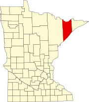
Lake County is a county in the U.S. state of Minnesota. As of the 2020 census, the population was 10,905. Its county seat is Two Harbors.

Grand Marais is a city and the county seat of Cook County, Minnesota, United States, of which it is the only municipality. It is on Lake Superior's North Shore. Grand Marais had a population of 1,337 at the 2020 census. Before it was settled by French Canadians and before Minnesota's statehood, it was inhabited by the Ojibwe.

Two Harbors is a city in and the county seat of Lake County, Minnesota, United States, along the shore of Lake Superior. The population was 3,633 at the 2020 census. Minnesota State Highway 61 serves as a main route in Two Harbors. Gooseberry Falls State Park is 13 miles (21 km) to the northeast. The city is home to a cargo shipping port for mined iron ore.
Rollins is an unincorporated community in Ault Township, Saint Louis County, Minnesota, United States.

The Two Harbors Light is the oldest operating lighthouse in the US state of Minnesota. Overlooking Lake Superior's Agate Bay, the lighthouse is located in Two Harbors, Minnesota. The construction of the lighthouse began in 1891 and was completed the following year, with the light being lit for the first time on April 14, 1892. The first Two Harbors keeper was Charles Lederle and there were normally three keepers assigned to make sure the light was lit every day. The Lighthouse was built to provide safe passage into the Agate Bay Harbor during the early 20th century, as Two Harbors was a major shipping point for the iron ore of the Mesabi Range.

The North Shore of Lake Superior runs from Duluth, Minnesota, United States, at the western end of the lake, to Thunder Bay and Nipigon, Ontario, Canada, in the north, to Sault Ste. Marie, Ontario in the east. The shore is characterized by alternating rocky cliffs and cobblestone beaches, with forested hills and ridges through which scenic rivers and waterfalls descend as they flow to Lake Superior.
Larsmont is an unincorporated community in Lake County, Minnesota, United States, on the North Shore of Lake Superior. It is five miles southwest of Two Harbors on the North Shore Scenic Drive.
Knife River is an unincorporated community in Lake County, Minnesota, United States; located on the North Shore of Lake Superior.
Fairbanks is an unincorporated community in Fairbanks Township, Saint Louis County, Minnesota, United States; located within the Superior National Forest.
Bassett is an unincorporated community in Bassett Township, Saint Louis County, Minnesota, United States located within the Superior National Forest.
Little Marais is an unincorporated community in Lake County, Minnesota, United States; located on the North Shore of Lake Superior.

Castle Danger is an unincorporated community in Silver Creek Township, Lake County, Minnesota, United States.

The Mataafa Storm of 1905, was a storm that occurred on the Great Lakes on November 27–28, 1905. The system moved across the Great Basin with moderate depth on November 26 and November 27, then east-northeastward across the Great Lakes on November 28. Fresh east winds were forecast for the afternoon and evening of November 27, with storm warnings in effect by the morning of November 28. Storm-force winds and heavy snows accompanied the cyclone's passage. The storm, named after the steamship Mataafa, ended up destroying or damaging about 29 vessels, killing 36 seamen, and causing shipping losses of US$ 3.567 million on Lake Superior.
Clover Valley is an unincorporated community in Duluth Township, Saint Louis County, Minnesota, United States.
Silver Creek is an unincorporated community in Silver Creek Township, Lake County, Minnesota, United States.
Highland is an unincorporated community in Lake County, Minnesota, United States.
Stewart is an unincorporated community in Lake County, Minnesota, United States. It is a surrounding community of Two Harbors.
Alger is an unincorporated community in Lake County, Minnesota, United States. It is nine miles north of Two Harbors, near the intersection of Lake County Highway 2 and Alger Grade, Township Road 24.