1585 Aleutian Islands earthquake

Last updated

1585 Aleutian Islands earthquake
Aleutian Islands amo 2014135 lrg.jpg
The epicenter of the earthquake is thought to have been in the eastern Aleutian Islands.
Local date11 June 1585 (1585-06-11)
Magnitude9.25 Mw
Epicenter Aleutian subduction zone
Type Megathrust
Areas affected Hawaii, Alaska
Sanriku, Japan
TsunamiYes
CasualtiesMany native people in Hawaii killed

The 1585 Aleutian Islands earthquake is the presumed source of a tsunami along the Sanriku coast of Japan on 11 June 1585, known only from vague historical accounts and oral traditions. The event was initially misdated to 1586, which led to it being associated with the deadly earthquakes in Peru and Japan of that year. A megathrust earthquake on the Aleutian subduction zone in the North Pacific Ocean was hypothesized as the tsunami's source. Paleotsunami evidence from shoreline deposits and coral rocks in Hawaii suggest that the 1585 event was a large megathrust earthquake with a moment magnitude (Mw) as large as 9.25.

Contents

Background

In 1586, a legend emerged in Japan describing a wave measuring up to two meters which struck near Tokura village in the Motoyoshi District of Miyagi Prefecture. [1] Surviving historical accounts from the period are ambiguous or incomplete, which has made it difficult to identify the tsunami's specific origin. The tsunami was dubbed the "orphan tsunami" or "ghost tsunami" due to the uncertainties regarding the event.

Tsunami event

According to Kenji Satake, a Japanese seismologist, the legend of the 1586 tsunami should be disregarded because it was a false event. There was no historical documentation of a tsunami striking the Sanriku coast in that year. [2]

In the aftermath of the deadly 1960 Valdivia earthquake in Chile and the associated tsunami in Japan, Seishi Ninomiya, a researcher at Tohoku University, gathered historical accounts of tsunamis along the Sanriku coasts and matched up the tsunami from the 1586 legend with a corresponding earthquake in Peru on 9 July that same year. The 8.1 Mw Peru earthquake of 1586 ruptured an estimated 175-km-long section of the Peru-Chile megathrust. Historical descriptions of the tsunami that struck locally in Callao reported two very different heights, 3.7 meters and 24 meters. [3] The latter was determined to be an exaggeration of the tsunami height after much evaluation; [4] a more accurate estimate for the 1586 Peru tsunami is 5 meters. [5] Further modelling of the Peru tsunami by a group of researchers in 2006 was unsuccessful in accurately matching the historical descriptions of the wave heights in Peru and Japan. [6] [4] Large tsunamis originating in Chile have been reported in Japan due to the orientation of the tsunami source, but Peru-sourced tsunamis are usually weaker because they are not directed towards Japan, suggesting that the claim of a Peru tsunami causing the 1586 event in Japan is incorrect. [7]

In another tsunami catalog compiled after the 1933 Sanriku earthquake, the author referenced a 1903 publication which stated that a tsunami occurred on 11 June 1585, or Tensho 13th year, 5th month and 14th day. Meanwhile, another tsunami event on 18 January 1586, was recorded, possibly associated with the 1586 Tenshō earthquake (ja). Because the Tenshō earthquake occurred in 1586, the Sanriku tsunami was incorrectly dated to 1586, coincidentally matching the Peru quake as well. [7]

Hawaiian culture

The Hawaiian Islands have been known to be hit with large, distant-sourced tsunamis and locally sourced megatsunamis. The last known megatsunami occurred more than 10,000 years ago. Throughout the Holocene, tsunamis have repeatedly struck the islands leaving behind evidence of inundation in the form of deposits. Historical legends passed down by the natives have also described tsunamis hitting the island. One of these tsunamis struck Kāne‘ohe Bay on the island of Oahu. Archaeological and historical evidences showed that the tsunami occurred sometime between 1040 and 1280 A.D. [8]

A chant composed between 1500 and 1600 described a tsunami-like event occurring on the western coast of Molokai. The chant is believed to be the oldest record of a tsunami in Hawaii.

"The sun shines brightly at Kalaeola which sank into the sea. A huge wave came and killed its inhabitants, scattering them and leaving only Papala'au; their cries are all about. [9] "

Future threat

At least 24 to 40 meters of slip has been accumulated since the earthquake of 1585 and it is possible for another event of a similar magnitude to occur. If a tsunami was generated, it would require just 4.5 hours of travel time to reach the Hawaiian Islands. [10]

Evidence

Hawaii

A study of the northwestern coast of Kaua‘i in 2002 discovered evidence of a large tsunami in a layer of buried sand, similar to the tsunami deposits found after the 1946 earthquake. [11]

The Makauwahi Cave where there is evidence of a major tsunami-like event in the 16th century. Makauwahi Cave crop.jpg
The Makauwahi Cave where there is evidence of a major tsunami-like event in the 16th century.

Earlier in 2001, at Makauwahi Sinkhole in the Makauwahi Cave complex, on the southern coast of Kaua‘i, researchers uncovered a 0.8 to 1-meter layer of deposit during an excavation of the site. The sinkhole is 30 to 35 meters wide and walls 6 to 25 meters high. The allochthonous deposit, consisting of stones and fragmented aeolianite were sourced from a distant location, confirming the occurrence of a major tsunami-like event in the Hawaiian Islands. The state of these boulders, cobbles, gravel, and sand, severely fractured and angular, concluded that they formed during one intense event. [12] Dating of the deposits presented a time period of 1430–1665 A.D..

In a 2014 study of the site led by Rhett Butler, researchers from the University of Hawaiʻi at Mānoa, National Tropical Botanical Garden and Pacific Tsunami Warning Center found the same deposit, 0.8 meters thick. They also measured the bottom of the sinkhole at 7.2 meters above the mean sea level, and location of the sinkhole 100 meters from the coast. The deposit volume is also estimated to be 600 cubic meters. [8]

Based on the location in which the deposit was found, the tsunami must be a very significant event. The layer deposited in the sinkhole was sourced by a tsunami much larger than anything generated by the largest Pacific earthquakes. The largest run-up height in modern times was from the 1960 Valdivia earthquake which tsunami run-up measured 3 meters. None of the recent tsunamis have been able to reach and inundate the Makauwahi Sinkhole, which lies 7.2 meters above sea level at a distance of 100 meters from the shore. [8]

Another research in 2017 revisited the site of the sinkhole to radiocarbon date plant materials in the deposit and found that the tsunami inundation occurred between 1425 and 1660 A.D. [10] Together with the required tsunami run-up heights, the tsunami may have been associated with the misdated Sanriku tsunami of 1586.

Elsewhere

The Sanriku orphan tsunami may have been associated with deposited materials in near Sendai City, Miyagi, which could not be explained by nearby earthquakes. [10] [13] Inscriptions on a monument at Tokura village said that the tsunami struck the northeastern coast of Japan with a height of 1 to 2 meters. [10]

There is paleotsunami evidence in nine locations in Oregon, Washington and British Columbia to show that a tsunami occurred near the Cascadia subduction zone prior to the 1700 event. The next prior event in Cascadia was a less energetic tsunami event inferred to have taken place between 1402 and 1502, with an uncertainty of ± 20 years. This rules out Cascadia as the cause of the 1585 tsunami. Dating of the event however, strongly supported the Aleutian Islands as being the tsunami source. [14]

The closest known historical earthquakes from 1585 to 1586 were the 1604 Arica, 1587 Guayllabamba and 1575 Valdivia earthquakes, which all generated tsunamis along the South American coast. However, no tsunamis from these events were ever measured on the Japanese coasts. [10]

Sedanka Island from space Aleuten-Sedanka.jpg
Sedanka Island from space

Paleotsunami studies on Sedanka Island near Amaknak Island found five large tsunami events before 1957. One of these tsunami deposits was found up to one kilometer inland and up to 18 meters above sea level. This tsunami event has been dated at 1530–1665 A.D. [15] [16]

Earthquake

The Aleutian-Alaska megathrust, source of the 1585 earthquake and tsunami Alaska earthquakes.jpg
The Aleutian-Alaska megathrust, source of the 1585 earthquake and tsunami

The Aleutian Islands lie near a convergent plate boundary where the Pacific Plate meets the North American Plate. The location where the plates converge is marked on the ocean floor by the Aleutian Trench. The Pacific Plate dives beneath the North American Plate along the Aleutian subduction zone which extends for approximately 4,000 km. The subduction zone is a large thrust fault capable of generating large megathrust earthquakes, sometimes tsunamigenic. The 1946 Aleutian Islands earthquake and 1964 Alaska earthquake, measuring 8.6 Mw and 9.2 Mw respectively, are examples of earthquakes on the subduction zone; both resulted in devastating tsunamis. [17] [18]

In the same 2014 study led by Butler, researchers simulated the tsunami from a 9.25 Mw earthquake in the eastern Aleutian Islands, west of the earthquake rupture. The rupture area is 100 km by 600 km with an average slip of 35 meters on the megathrust. [8] Their model was found to be sufficient enough to inundate the sinkhole. Along the Pacific Northwest coast, the tsunami measured a maximum of 9 meters while the mean height was 3.5 meters. [10] The orientation of the megathrust with respect to the Hawaiian Islands allowed for much directivity of the tsunami energy. The results of the model did not rule out the possibility of other distant tsunami source locations. However, such events would have to greatly exceed the fault slip seen in other historically large events. [8]

See also

Related Research Articles

<span class="mw-page-title-main">1700 Cascadia earthquake</span> Megathrust earthquake in the North West Pacific region

The 1700 Cascadia earthquake occurred along the Cascadia subduction zone on January 26, 1700, with an estimated moment magnitude of 8.7–9.2. The megathrust earthquake involved the Juan de Fuca Plate from mid-Vancouver Island, south along the Pacific Northwest coast as far as northern California. The plate slipped an average of 20 meters (66 ft) along a fault rupture about 1,000 kilometers long.

<span class="mw-page-title-main">Cascadia subduction zone</span> Convergent plate boundary that stretches from northern Vancouver Island to Northern California

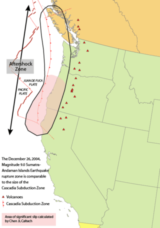
The Cascadia subduction zone is a 960 km (600 mi) fault at a convergent plate boundary, about 110–160 km (70–100 mi) off the Pacific coast, that stretches from northern Vancouver Island in Canada to Northern California in the United States. It is capable of producing 9.0+ magnitude earthquakes and tsunamis that could reach 30 m (98 ft). The Oregon Department of Emergency Management estimates shaking would last 5–7 minutes along the coast, with strength and intensity decreasing further from the epicenter. It is a very long, sloping subduction zone where the Explorer, Juan de Fuca, and Gorda plates move to the east and slide below the much larger mostly continental North American Plate. The zone varies in width and lies offshore beginning near Cape Mendocino, Northern California, passing through Oregon and Washington, and terminating at about Vancouver Island in British Columbia.

Megathrust earthquakes occur at convergent plate boundaries, where one tectonic plate is forced underneath another. The earthquakes are caused by slip along the thrust fault that forms the contact between the two plates. These interplate earthquakes are the planet's most powerful, with moment magnitudes (Mw) that can exceed 9.0. Since 1900, all earthquakes of magnitude 9.0 or greater have been megathrust earthquakes.

<span class="mw-page-title-main">1946 Aleutian Islands earthquake</span> Earthquake near the Aleutian Islands, Alaska

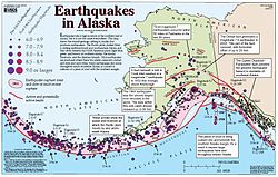
The 1946 Aleutian Islands earthquake occurred near the Aleutian Islands, Alaska on April 1, 1946. The shock measured 8.6, Mt 9.3 or 7.4. It had a maximum Mercalli intensity of VI (Strong). It resulted in 165–173 casualties and over US $26 million in damage. The seafloor along the fault was elevated, triggering a Pacific-wide tsunami with multiple destructive waves at heights ranging from 45–138 ft (14–42 m). The tsunami obliterated the Scotch Cap Lighthouse on Unimak Island, Alaska among others, and killed all five lighthouse keepers. Despite the destruction to the Aleutian Island Unimak, the tsunami had almost an imperceptible effect on the Alaskan mainland.

<span class="mw-page-title-main">Aleutian Trench</span> An oceanic trench along the southern coastline of Alaska and the Aleutian islands

The Aleutian Trench is an oceanic trench along a convergent plate boundary which runs along the southern coastline of Alaska and the Aleutian islands. The trench extends for 3,400 kilometres (2,100 mi) from a triple junction in the west with the Ulakhan Fault and the northern end of the Kuril–Kamchatka Trench, to a junction with the northern end of the Queen Charlotte Fault system in the east. It is classified as a "marginal trench" in the east as it runs along the margin of the continent. The subduction along the trench gives rise to the Aleutian Arc, a volcanic island arc, where it runs through the open sea west of the Alaska Peninsula. As a convergent plate boundary, the trench forms part of the boundary between two tectonic plates. Here, the Pacific Plate is being subducted under the North American Plate at a dip angle of nearly 45°. The rate of closure is 7.5 centimetres (3 in) per year.

<span class="mw-page-title-main">Seismicity of the Sanriku coast</span>

The seismicity of the Sanriku coast identifies and describes the seismic activity of an area of Japan. Seismicity refers to the frequency, type and size of earthquakes experienced over a period of time. The Sanriku Coast is a descriptive term referring to the coastal areas of the former provinces of Rikuō in Aomori, Rikuchū in Aomori, and Rikuzen in Miyagi.

<span class="mw-page-title-main">Teletsunami</span> Massive tsunamis that strike a thousand kilometers or more from their source

A teletsunami is a tsunami that originates from a distant source, defined as more than 1,000 km (620 mi) away or three hours' travel from the area of interest, sometimes travelling across an ocean. All teletsunamis have been generated by major earthquakes such as the 1755 Lisbon earthquake, 1960 Valdivia earthquake, 1964 Alaska earthquake, 2004 Indian Ocean earthquake, 2011 Tohoku earthquake, and the 2021 South Sandwich Islands earthquakes.

<span class="mw-page-title-main">1896 Sanriku earthquake</span> Japanese tsunami earthquake

The 1896 Sanriku earthquake was one of the most destructive seismic events in Japanese history. The 8.5 magnitude earthquake occurred at 19:32 on June 15, 1896, approximately 166 kilometres (103 mi) off the coast of Iwate Prefecture, Honshu. It resulted in two tsunami waves which destroyed about 9,000 homes and caused at least 22,000 deaths. The waves reached a then-record height of 38.2 metres (125 ft); this would remain the highest on record until waves from the 2011 Tōhoku earthquake exceeded that height by more than 2 metres.

The 1965 Rat Islands earthquake occurred at 05:01 UTC, on 4 February. It had a magnitude of 8.7 and triggered a tsunami of over 10 m on Shemya Island, but caused very little damage.

<span class="mw-page-title-main">1944 Tōnankai earthquake</span> Earthquake and tsunami affecting southern Japan

The 1944 Tōnankai earthquake occurred at 13:35 local time on 7 December. It had an estimated magnitude of 8.1 on the moment magnitude scale and a maximum felt intensity of greater than 5 Shindo. It triggered a large tsunami that caused serious damage along the coast of Wakayama Prefecture and the Tōkai region. Together, the earthquake and tsunami caused 3,358 casualties.

<span class="mw-page-title-main">Tsunami earthquake</span> Type of earthquake which triggers a tsunami of far-larger magnitude

In seismology, a tsunami earthquake is an earthquake which triggers a tsunami of significantly greater magnitude, as measured by shorter-period seismic waves. The term was introduced by Japanese seismologist Hiroo Kanamori in 1972. Such events are a result of relatively slow rupture velocities. They are particularly dangerous as a large tsunami may arrive at a coastline with little or no warning.

The November 1960 Peru earthquake occurred offshore northern Peru on November 20 at 17:02 local time. The magnitude of the earthquake was Ms  6.75 by using the conventional surface-wave magnitude measurement within a shorter duration of ~20 s. However, there is a large discrepancy between the magnitudes in Ms  and Mw  in this earthquake. The discrepancy was caused from the earthquake's long source duration of about 130 s, and by calculating the seismic moment, the magnitude would be Mw  7.6 or Mw  7.8, according to different sources. This earthquake belongs to a category of earthquakes with slow rupture velocities and potential of producing tsunamis larger than those expected from the moment magnitudes.

The 1839 Martinique earthquake occurred on the morning of January 11 with an estimated magnitude of 7.8 Ms , the largest in the Lesser Antilles since 1690. The maximum intensity of this earthquake was assigned IX on both the Mercalli and MSK intensity scales, which left the cities of Saint-Pierre and Fort Royal almost completely destroyed. Estimation on the number of human losses varies from 390 to even 4,000 making this one of the deadliest earthquakes in the Caribbean.

<span class="mw-page-title-main">1586 Tenshō earthquake</span> Earthquake in Japan

The Tenshō earthquake occurred in Japan on January 18, 1586 at 23:00 local time. This earthquake had an estimated seismic magnitude of 7.9, and an epicenter in Honshu's Chūbu region. It caused an estimated 8,000 fatalities and damaged 10,000 houses across the prefectures of Toyama, Hyōgo, Kyōto, Osaka, Nara, Mie, Aichi, Gifu, Fukui, Ishikawa and Shizuoka. Historical documentation of this earthquake was limited because it occurred during the Sengoku period.

The Nemuro-Oki earthquake in scientific literature, occurred on June 17 at 12:55 local time. It struck with an epicenter just off the Nemuro Peninsula in northern Hokkaidō, Japan. It measured 7.8–7.9 on the moment magnitude scale (Mw ), 8.1 on the tsunami magnitude scale (Mt ) and 7.4 on the Japan Meteorological Agency magnitude scale (MJMA ).

The 1737 Kamchatka earthquake occurred on October 17 or 16 near the southern tip of present-day Russia's Kamchatka Peninsula. The shock was felt at approximately 03:00 local time or 16:00 UTC by residents on the peninsula and Kuril Islands. The earthquake struck at a shallow depth of roughly 40 km beneath the peninsula. The earthquake had an estimated magnitude of 9.0–9.3 on the moment magnitude scale.

<span class="mw-page-title-main">2021 Chignik earthquake</span> 7th largest earthquake in the US

An earthquake occurred off the coast of the Alaska Peninsula on July 28, 2021, at 10:15 p.m. local time. The large megathrust earthquake had a moment magnitude of 8.2 according to the United States Geological Survey (USGS). A tsunami warning was issued by the National Oceanic and Atmospheric Administration (NOAA) but later cancelled. The mainshock was followed by a number of aftershocks, including three that were of magnitude 5.9, 6.1 and 6.9 respectively.

The 1586 Lima–Callao earthquake occurred on July 9 along the coast of Peru, near the capital Lima. A section of the Peruvian coast, stretching from Caravelí to Trujillo, north to south, was severely damaged by the earthquake. Major destruction occurred in the capital city Lima as well. The estimated moment magnitude (Mw ) 8.1 earthquake triggered a locally damaging tsunami up to 5 m (16 ft). This was the first major earthquake to strike the city of Lima since its establishment in 1535.

The 1841 Kamchatka earthquake occurred in the Pacific Ocean on May 17 at 08:00 local time. The earthquake had an epicenter off the Russian Far East's Kamchatka Peninsula. With an estimated moment magnitude of 9.0 or higher, it is one of the largest to strike the region. A large tsunami with up to 15 meters in run-up along the coast.

A paleotsunami is a tsunami that occurs prior to written history where there are no documented observations. Paleotsunamis are evidenced by modern technology and scientific research. One of the largest was a megatsunami resulting from the asteroid that wiped out the dinosaurs.

References

  1. National Geophysical Data Center. "Tsunami Event Information". ngdc.noaa.gov. National Geophysical Data Center / World Data Service: NCEI/WDS Global Historical Tsunami Database. NOAA National Centers for Environmental Information. doi:10.7289/V5PN93H7 . Retrieved 8 July 2021.
  2. Yoshinobu Tsuji (2013). "Catalog of Distant Tsunamis Reaching Japan from Chile and Peru". Report of Tsunami Engineering. 30: 61–68. CiteSeerX   10.1.1.723.1716 .
  3. Evgueni A. Kulikov; Alexander B. Rabinovich; Richard E. Thomson (2005). "Estimation of Tsunami Risk for the Coasts of Peru and Northern Chile". Natural Hazards. 35 (2): 185–209. Bibcode:2005NatHa..35..185K. doi:10.1007/s11069-004-4809-3. S2CID   140620121.
  4. 1 2 Kenji Satake (2017). "Tsunami on Sanriku Coast in 1586: Orphan or Ghost Tsunami ?". Fall Meeting 2017. American Geophysical Union. 2017. Bibcode:2017AGUFMNH12A..08S . Retrieved 8 July 2021.
  5. L. Dorbath; A. Cisternas; C. Dorbath (1990). "Assessment of the size of large and great historical earthquakes in Peru". Bulletin of the Seismological Society of America. 80: 551–576. Retrieved 8 July 2021.
  6. Kumiji Iida; Doak C Cox (1967). George Pararas-Carayannis (ed.). "PRELIMINARY CATALOG OF TSUNAMIS OCCURRING IN THE PACIFIC OCEAN" (PDF). Hawaii Institute of Geophysics. 67-10. University of Hawaii (5).
  7. 1 2 Kenji Satake; Mohammad Heidarzadeh; Marco Quiroz; Rodrigo Cienfuegos (2020). "History and features of trans-oceanic tsunamis and implications for paleo-tsunami studies". Earth-Science Reviews. 202 (103112): 103112. Bibcode:2020ESRv..20203112S. doi:10.1016/j.earscirev.2020.103112. S2CID   212778611 . Retrieved 8 July 2021.
  8. 1 2 3 4 5 Rhett Butler; David Burney; David Walsh (2014). "Paleotsunami evidence on Kaua'i and numerical modeling of a great Aleutian tsunami". Geophysical Research Letters. 41 (19): 6795–6802. Bibcode:2014GeoRL..41.6795B. doi: 10.1002/2014GL061232 .
  9. James F. Lander; Patricia A. Lockridge (1989). United States Tsunamis: (including United States Possessions) : 1690-1988. Boulder, Colorado: U.S. Department of Commerce, National Oceanic and Atmospheric Administration, National Environmental Satellite, Data, and Information Service, National Geophysical Data Center. p. 265.
  10. 1 2 3 4 5 6 Rhett Butler; David A. Burney; Kenneth H. Rubin; David Walsh (2017). "The orphan Sanriku tsunami of 1586: new evidence from coral dating on Kaua'i". Natural Hazards. 88 (2): 797–819. Bibcode:2017NatHa..88..797B. doi:10.1007/s11069-017-2902-7. S2CID   134237666.
  11. David A. Burney (2002). "Late Quaternary Chronology and Stratigraphy of Twelve Sites On Kaua'i". Radiocarbon. Cambridge University Press. 44 (1): 13–44. Bibcode:2002Radcb..44...13B. doi: 10.1017/S003382220006464X .
  12. Burney, David A.; James, Helen F.; Burney, Lida Pigott; Olson, Storrs L.; Kikuchi, William; Wagner, Warren L.; Burney, Mara; McCloskey, Deirdre; Kikuchi, Delores; Grady, Frederick V.; Gage II, Reginald; Nishek, Robert (November 2001). "Fossil evidence for a diverse biota from Kaua'i and its transformation since human arrival". Ecological Monographs. 71 (4): 615–641. doi:10.1890/0012-9615(2001)071[0615:FEFADB]2.0.CO;2 . Retrieved 9 July 2021.
  13. Yuki Sawai; Yushiro Fujii; Osamu Fujiwara; Takanobu Kamataki; Junko Komatsubara; Yukinobu Okamura; Kenji Satake; Masanobu Shishikura (2008). "Marine incursions of the past 1500 years and evidence of tsunamis at Suijin-numa, a coastal lake facing the Japan Trench" (PDF). The Holocene. 18 (4): 517–528. Bibcode:2008Holoc..18..517S. doi:10.1177/0959683608089206. S2CID   55355007 . Retrieved 9 July 2021.
  14. Robert Peters; Bruce Jaffe; Guy Gelfenbaum (2007). "Distribution and sedimentary characteristics of tsunami deposits along the Cascadia margin of western North America". Sedimentary Geology. 200 (3–4): 372–386. Bibcode:2007SedG..200..372P. doi:10.1016/j.sedgeo.2007.01.015 . Retrieved 9 July 2021.
  15. Witter, R. C., G. A. Carver, A. M. Bender, R. W. Briggs, G. R. Gelfenbaum, and R. D. Koehler (2013). "Six large tsunamis in the past ~1700 years at Stardust Bay, Sedanka Island, Alaska". Abstract NH44A-08 Presented at 2013 Fall Meeting, AGU. 2013. Bibcode:2013AGUFMNH44A..08W . Retrieved 9 July 2021.{{cite journal}}: CS1 maint: multiple names: authors list (link)
  16. Robert C. Witter, Gary A. Carver, Richard W. Briggs, Guy Gelfenbaum, Richard D. Koehler, SeanPaul La Selle, Adrian M. Bender, Simon E. Engelhart, Eileen Hemphill-Haley, Troy D. Hill (2016). "Unusually large tsunamis frequent a currently creeping part of the Aleutian megathrust". Geophysical Research Letters. 43 (1): 76–84. Bibcode:2016GeoRL..43...76W. doi: 10.1002/2015GL066083 . S2CID   131231692.{{cite journal}}: CS1 maint: multiple names: authors list (link)
  17. "M 8.6 - 1946 Aleutian Islands (Unimak Island) Earthquake, Alaska". earthquake.usgs.gov. USGS. Retrieved 9 July 2021.
  18. "M 9.2 - 1964 Prince William Sound Earthquake, Alaska". earthquake.usgs.gov. USGS. Retrieved 9 July 2021.

Further reading