The Modified Mercalli intensity scale measures the effects of an earthquake at a given location. This is in contrast with the seismic magnitude usually reported for an earthquake.

Earthquakes are caused by movements within the Earth's crust and uppermost mantle. They range from events too weak to be detectable except by sensitive instrumentation, to sudden and violent events lasting many minutes which have caused some of the greatest disasters in human history. Below, earthquakes are listed by period, region or country, year, magnitude, cost, fatalities and number of scientific studies.

The New Madrid Seismic Zone (NMSZ), sometimes called the New Madrid Fault Line, is a major seismic zone and a prolific source of intraplate earthquakes in the Southern and Midwestern United States, stretching to the southwest from New Madrid, Missouri.
The 1999 Hector Mine earthquake occurred in Southern California, United States, on October 16 at 02:46:50 PDT. Its moment magnitude was 7.1 and the earthquake was preceded by 12 foreshocks, the largest of which had a magnitude of 3.8. The event is thought to have been triggered by the 1992 Landers earthquake which occurred seven years earlier. It also deformed nearby faults vertically and horizontally. The earthquake's hypocenter was at a depth of 20 kilometers and its epicenter at 34.603° N 116.265° W.
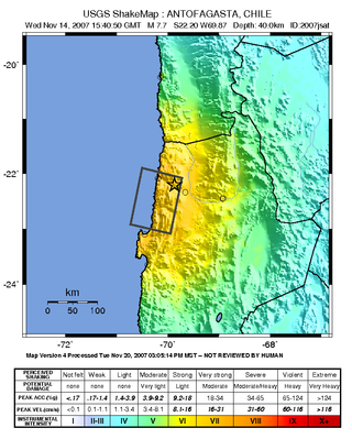
The 2007 Tocopilla earthquake occurred on November 14 at . Its epicenter was located between Quillagua and Tocopilla, affecting the Tarapacá and the Antofagasta regions in northern Chile. The earthquake had a moment magnitude of 7.7 and lasted about 3 minutes and 35 seconds. Seventeen aftershocks of magnitude greater than 5.3, including one of magnitude 7.1 and two others of magnitude 6.3 or higher, were recorded. The Pacific Tsunami Warning Center issued a tsunami warning, stating a tsunami had been generated; after one hour, this warning was cancelled. The earthquake was felt from Santiago, 1,245 km south from the epicenter, to La Paz, about 700 km north-northeast.

The Wabash Valley Seismic Zone is a tectonic region located in the Midwestern United States, centered on the valley of the Lower Wabash River, along the state line between southeastern Illinois and southwestern Indiana.

The 2002 Denali earthquake occurred at 22:12:41 UTC November 3 with an epicenter 66 km ESE of Denali National Park, Alaska, United States. This 7.9 Mw earthquake was the largest recorded in the United States in 37 years. The shock was the strongest ever recorded in the interior of Alaska. Due to the remote location, there were no fatalities and only one injury.

The 2008 Chino Hills earthquake occurred at 11:42:15 am PDT on July 29 in Southern California. The epicenter of the magnitude 5.4 earthquake was in Chino Hills, c. 28 miles (45 km) east-southeast of downtown Los Angeles. Movement on an oblique-slip fault resulted in a maximum Mercalli intensity of VI (Strong). Though there were no deaths, eight people were injured, and it caused considerable damage in numerous structures throughout the area and caused some amusement park facilities to shut down their rides. The earthquake led to increased discussion regarding the possibility of a stronger earthquake in the future.
The 1998 Pymatuning earthquake occurred in the U.S. state of Pennsylvania on September 25 at 19:52 UTC. With a magnitude of 5.2 , it was the largest recorded earthquake in Pennsylvania's history.

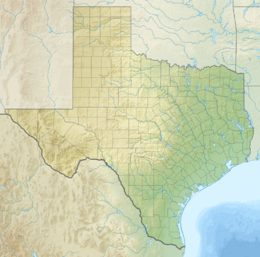
In the early morning hours of August 16, 1931, a powerful earthquake occurred in West Texas with a maximum Mercalli intensity of VIII (Severe). Estimates of its magnitude range between 5.8–6.4 mb, making it the most powerful earthquake ever recorded in Texas history. Its epicenter was near the town of Valentine, Texas; there, the earthquake caused damage to many homes and buildings. The earthquake may have been caused by movement along oblique-slip faulting in West Texas, the most seismically-active region in the state. Shaking from the earthquake was perceptible within a 400 mi (640 km) radius of the epicenter, affecting four U.S. states and northern Mexico. Several foreshocks and aftershocks accompanied the primary temblor, with the aftershocks continuing until at least November 3, 1931. The main earthquake caused no fatalities, though several people sustained minor injuries; the damage in Valentine amounted to $50,000–$75,000.
The 1984 Morgan Hill earthquake occurred on April 24 at in the Santa Clara Valley of Northern California. The shock had a moment magnitude of 6.2 and a maximum Mercalli intensity of VIII (Severe). The epicenter was located near Mount Hamilton in the Diablo Range of the California Coast Ranges. Nearby communities sustained serious damage with financial losses of at least US$7.5 million.

The 1968 Illinois earthquake was the largest recorded earthquake in the U.S. Midwestern state of Illinois. Striking at 11:02 am on November 9, it measured 5.4 on the Richter scale. Although no fatalities occurred, the event caused considerable structural damage to buildings, including the toppling of chimneys and shaking in Chicago, the region's largest city. The earthquake was one of the most widely felt in U.S. history, largely affecting 23 states over an area of 580,000 sq mi (1,500,000 km2). In studying its cause, scientists discovered the Cottage Grove Fault in the Southern Illinois Basin.

The Western Quebec Seismic Zone is a seismically active area in the Ottawa Valley in Eastern Ontario and Western Quebec. The zone stretches from Montreal to Témiscaming and from Cornwall up along the Laurentian Mountains.
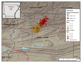
The Guy-Greenbrier earthquake swarm occurred in central Arkansas beginning in August 2010. The epicenters of earthquakes in the swarm showed a linear distribution, with a clear overall shift in activity towards the southwest with time, and the largest event in the swarm was the 2011 Arkansas earthquake, at 4.7 on the moment magnitude scale.
The 1960 Concepción earthquakes were a succession of three destructive earthquakes that happened between 21 and 22 May 1960. They formed part of the foreshock sequence for the 1960 Valdivia earthquake, the largest recorded earthquake in history.

The 2011 Oklahoma earthquake was a 5.7 magnitude intraplate earthquake which occurred near Prague, Oklahoma on November 5 at 10:53 p.m. CDT in the U.S. state of Oklahoma. The epicenter of the earthquake was in the vicinity of several active wastewater injection wells. According to the United States Geological Survey (USGS), it was the most powerful earthquake ever recorded in Oklahoma until the 2016 Oklahoma earthquake. The previous record was a 5.5 magnitude earthquake that struck near the town of El Reno in 1952. The quake's epicenter was approximately 44 miles (71 km) east-northeast of Oklahoma City, near the town of Sparks and was felt in the neighboring states of Texas, Arkansas, Kansas and Missouri and even as far away as Tennessee and Wisconsin. The quake followed several minor quakes earlier in the day, including a 4.7 magnitude foreshock. The quake had a maximum perceived intensity of VIII (Severe) on the Mercalli intensity scale in the area closest to the epicenter. Numerous aftershocks were detected after the main quake, with a few registering at 4.0 magnitude.

The 2014 Ludian earthquake struck Ludian County, Yunnan, China, with a moment magnitude of 6.1 on 3 August. The earthquake killed at least 617 people, injuring at least 2,400 others. As of 5 August 2014, 112 people remain missing. Over 12,000 houses collapsed and 30,000 were damaged. According to the United States Geological Survey, the earthquake occurred 29 km (18 mi) WSW of Zhaotong city at 16:30 local time (08:30 UTC).
The 2019 Ridgecrest earthquakes of July 4 and 5 occurred north and northeast of the town of Ridgecrest, California located in Kern County and west of Searles Valley. They included three initial main shocks of magnitudes 6.4, 5.4, and 7.1, and many perceptible aftershocks, mainly within the area of the Naval Air Weapons Station China Lake. Eleven months later, a Mw 5.5 aftershock took place to the east of Ridgecrest. The first main shock occurred on Thursday, July 4 at 10:33 a.m. PDT, approximately 18 km (11.2 mi) ENE of Ridgecrest, and 13 km (8.1 mi) WSW of Trona, on a previously unnoticed NE-SW trending fault where it intersects the NW-SE trending Little Lake Fault Zone. This quake was preceded by several smaller earthquakes, and was followed by more than 1,400 detected aftershocks. The M 5.4 and M 7.1 quakes struck on Friday, July 5 at 4:08 a.m. and 8:19 p.m. PDT approximately 10 km (6 miles) to the northwest. The latter, now considered the mainshock, was the most powerful earthquake to occur in the state in 20 years. Subsequent aftershocks extended approximately 50 km (~30 miles) along the Little Lake Fault Zone.
The 2019 Cotabato earthquakes were an earthquake swarm which struck the province of Cotabato on the island of Mindanao in the Philippines in October 2019. Three of these earthquakes were above 6.0 on the moment magnitude scale with a Mercalli intensity of VIII. More than 40 people have been reported dead or missing and nearly 800 were injured as a result of these events.