Related Research Articles

An earthquake – also called a quake, tremor, or temblor – is the shaking of the Earth's surface resulting from a sudden release of energy in the lithosphere that creates seismic waves. Earthquakes can range in intensity, from those so weak they cannot be felt, to those violent enough to propel objects and people into the air, damage critical infrastructure, and wreak destruction across entire cities. The seismic activity of an area is the frequency, type, and size of earthquakes experienced over a particular time. The seismicity at a particular location in the Earth is the average rate of seismic energy release per unit volume.
In seismology, an aftershock is a smaller earthquake that follows a larger earthquake, in the same area of the main shock, caused as the displaced crust adjusts to the effects of the main shock. Large earthquakes can have hundreds to thousands of instrumentally detectable aftershocks, which steadily decrease in magnitude and frequency according to a consistent pattern. In some earthquakes the main rupture happens in two or more steps, resulting in multiple main shocks. These are known as doublet earthquakes, and in general can be distinguished from aftershocks in having similar magnitudes and nearly identical seismic waveforms.

The 1811–1812 New Madrid earthquakes were a series of intense intraplate earthquakes beginning with an initial earthquake of moment magnitude 7.2–8.2 on December 16, 1811, followed by a moment magnitude 7.4 aftershock on the same day. Two additional earthquakes of similar magnitude followed in January and February 1812. They remain the most powerful earthquakes to hit the contiguous United States east of the Rocky Mountains in recorded history. The earthquakes, as well as the seismic zone of their occurrence, were named for the Mississippi River town of New Madrid, then part of the Louisiana Territory and now within the U.S. state of Missouri.

The New Madrid Seismic Zone (NMSZ), sometimes called the New Madrid Fault Line, is a major seismic zone and a prolific source of intraplate earthquakes in the Southern and Midwestern United States, stretching to the southwest from New Madrid, Missouri.
In seismology, an earthquake swarm is a sequence of seismic events occurring in a local area within a relatively short period. The time span used to define a swarm varies, but may be days, months, or years. Such an energy release is different from the situation when a major earthquake is followed by a series of aftershocks: in earthquake swarms, no single earthquake in the sequence is obviously the main shock. In particular, a cluster of aftershocks occurring after a mainshock is not a swarm.

The 1987 Edgecumbe earthquake measured 6.5 on the moment magnitude scale and struck the Bay of Plenty region of New Zealand at 1:42 pm on 2 March. The hypocentre was at a shallow depth of 8 km. The epicentre was 2.24 kilometres (1.39 mi) south-south-east of the town of Matata, and 15 kilometres (9.3 mi) north-north-west of Edgecumbe, on the Rangitaiki Plains. It was the most damaging earthquake New Zealand had experienced since the 1968 Inangahua earthquake.
The 2008 Illinois earthquake was one of the largest earthquakes ever recorded in the Midwest state of Illinois. This moderate strike-slip shock measured 5.2 on the moment magnitude scale and had a maximum Mercalli intensity of VII (Very strong). It occurred at 04:36:59 local time on April 18 near Bellmont and Mount Carmel, Illinois, within the Wabash Valley Seismic Zone. Earthquakes in this part of the country are often felt at great distances.
In seismology, doublet earthquakes – and more generally, multiplet earthquakes – were originally identified as multiple earthquakes with nearly identical waveforms originating from the same location. They are now characterized as distinct earthquake sequences having two main shocks of similar magnitude, sometimes occurring within tens of seconds, but sometimes separated by years. The similarity of magnitude – often within 0.4 magnitude – distinguishes multiplet events from aftershocks, which start at about 1.2 magnitude less than the parent shock and decrease in magnitude and frequency according to known laws.
The Brawley Seismic Zone (BSZ), also known as the Brawley fault zone, is a predominantly extensional tectonic zone that connects the southern terminus of the San Andreas Fault with the Imperial Fault in Southern California. The BSZ is named for the nearby town of Brawley in Imperial County, California, and the seismicity there is characterized by earthquake swarms.
The 1995 Gulf of Aqaba earthquake occurred on November 22 at 06:15 local time and registered 7.3 on the Mw scale. The epicenter was located in the central segment of the Gulf of Aqaba, the narrow body of water that separates Egypt's Sinai Peninsula from the western border of Saudi Arabia. At least 8 people were killed and 30 were injured in the meizoseismal area.
The 1872 North Cascades earthquake occurred at 9:40 p.m. local time on December 14 in central Washington Territory. A maximum Mercalli intensity of VIII (Severe) was assessed for several locations, though less intense shaking was observed at many other locations in Washington, Oregon, and British Columbia. Some of these intermediate outlying areas reported V (Moderate) to VII shaking, but intensities as high as IV (Light) were reported as far distant as Idaho and Montana. Due to the remote location of the mainshock and a series of strong aftershocks, damage to structures was limited to a few cabins close to the areas of the highest intensity.
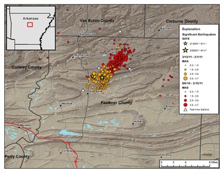
The Guy-Greenbrier earthquake swarm occurred in central Arkansas beginning in August 2010. The epicenters of earthquakes in the swarm showed a linear distribution, with a clear overall shift in activity towards the southwest with time, and the largest event in the swarm was the 2011 Arkansas earthquake, at 4.7 on the moment magnitude scale.

The 2011 Oklahoma earthquake was a 5.7 magnitude intraplate earthquake which occurred near Prague, Oklahoma on November 5 at 10:53 p.m. CDT in the U.S. state of Oklahoma. The epicenter of the earthquake was in the vicinity of several active wastewater injection wells. According to the United States Geological Survey (USGS), it was the most powerful earthquake ever recorded in Oklahoma until the 2016 Oklahoma earthquake. The previous record was a 5.5 magnitude earthquake that struck near the town of El Reno in 1952. The quake's epicenter was approximately 44 miles (71 km) east-northeast of Oklahoma City, near the town of Sparks and was felt in the neighboring states of Texas, Arkansas, Kansas and Missouri and even as far away as Tennessee and Wisconsin. The quake followed several minor quakes earlier in the day, including a 4.7 magnitude foreshock. The quake had a maximum perceived intensity of VIII (Severe) on the Mercalli intensity scale in the area closest to the epicenter. Numerous aftershocks were detected after the main quake, with a few registering at 4.0 magnitude.
This is a list of different types of earthquake.

The Oklahoma earthquake swarms are an ongoing series of human activity-induced earthquakes affecting central Oklahoma, southern Kansas, northern Texas since 2009. Beginning in 2009, the frequency of earthquakes in the U.S. state of Oklahoma rapidly increased from an average of fewer than two 3.0+ magnitude earthquakes per year since 1978 to hundreds each year in the 2014–17 period. Thousands of earthquakes have occurred in Oklahoma and surrounding areas in southern Kansas and North Texas since 2009. Scientific studies attribute the rise in earthquakes to the disposal of wastewater produced during oil extraction that has been injected more deeply into the ground.

The 2000 Tottori earthquake occurred on 6 October 2000, at 13:30:20 local time with a moment magnitude of 6.7 and a maximum Mercalli intensity of VIII (Severe). The epicenter was near Yonago and Matsue. About $150 million in damage was caused and between 130–182 people were injured.
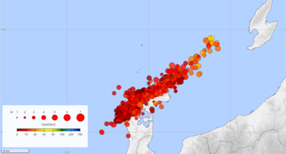
The 2019 Ridgecrest earthquakes of July 4 and 5 occurred north and northeast of the town of Ridgecrest, California located in Kern County and west of Searles Valley. They included three initial main shocks of Mw magnitudes 6.4, 5.4, and 7.1, and many perceptible aftershocks, mainly within the area of the Naval Air Weapons Station China Lake. Eleven months later, a Mw 5.5 aftershock took place to the east of Ridgecrest. The first main shock occurred on Thursday, July 4 at 10:33 a.m. PDT, approximately 18 km (11.2 mi) ENE of Ridgecrest, and 13 km (8.1 mi) WSW of Trona, on a previously unnoticed NE-SW trending fault where it intersects the NW-SE trending Little Lake Fault Zone. This quake was preceded by several smaller earthquakes, and was followed by more than 1,400 detected aftershocks. The M 5.4 and M 7.1 quakes struck on Friday, July 5 at 4:08 a.m. and 8:19 p.m. PDT approximately 10 km (6 miles) to the northwest. The latter, now considered the mainshock, was the most powerful earthquake to occur in the state in 20 years. Subsequent aftershocks extended approximately 50 km (~30 miles) along the Little Lake Fault Zone.
The 1934 Hansel Valley earthquake occurred on March 12 at approximately 8:05 a.m. MST with a moment magnitude of 6.6 and a maximum Mercalli intensity of VIII (Severe). The shock originated in the Hansel Valley at the north end of the Great Salt Lake in Utah in the United States. Damage was mostly confined to vulnerable buildings, and two people died. The dip-slip (normal) fault that generated the shock ruptured the surface of the ground and other geologic features were documented. A large aftershock occurred three hours after the initial event and may have caused additional damage.
References
- ↑ "CERI - Public Awareness -". ceri.memphis.edu. Archived from the original on March 7, 2011.
- ↑ Rabak, Ivan; Langston, Charles; Bodin, Paul; Horton, Steve; Withers, Mitch; Powell, Christine (1 May 2010). "The enola, Arkansas, intraplate swarm of 2001". Seismological Research Letters. 81 (3): 549–559. Bibcode:2010SeiRL..81..549R. doi:10.1785/gssrl.81.3.549 . Retrieved May 23, 2024.
- ↑ Rabak, I.; Bodin, P.; Langston, C.; Horton, S.; Withers, M.; Langston, T. (1 December 2002). "The Enola, Arkansas, Sequence of 2001: a Recurring Earthquake Swarm in "Stable Continental" Crust?". AGU Fall Meeting Abstracts. 2002: S22D–05. Bibcode:2002AGUFM.S22D..05R.
- ↑ McFarland, John David (2001). "The May 2001 Faulkner County Earthquakes" (PDF). Arkansas Geological Commission: 1–5. Retrieved May 23, 2024.