The Modified Mercalli intensity scale measures the effects of an earthquake at a given location. This is in contrast with the seismic magnitude usually reported for an earthquake.

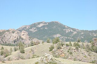
The Laramie Mountains are a range of moderately high peaks on the eastern edge of the Rocky Mountains in the U.S states of Wyoming and Colorado. The range is the northernmost extension of the line of the ranges along the eastern side of the Rockies, and in particular of the higher peaks of the Front Range directly to the south. North of the range, the gap between the Laramie range and the Bighorn Mountains provided the route for historical trails, such as the Oregon Trail, the Mormon Trail, and the Pony Express.

The Sevier orogeny was a mountain-building event that affected western North America from northern Canada to the north to Mexico to the south.

The geology of the Rocky Mountains is that of a discontinuous series of mountain ranges with distinct geological origins. Collectively these make up the Rocky Mountains, a mountain system that stretches from Northern British Columbia through central New Mexico and which is part of the great mountain system known as the North American Cordillera.

The Wyoming Craton is a craton in the west-central United States and western Canada – more specifically, in Montana, Wyoming, southern Alberta, southern Saskatchewan, and parts of northern Utah. Also called the Wyoming Province, it is the initial core of the continental crust of North America.

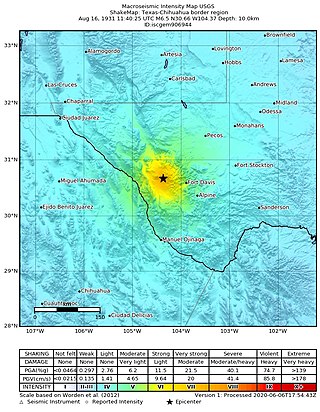
In the early morning hours of August 16, 1931, a powerful earthquake occurred in West Texas with a maximum Mercalli intensity of VIII (Severe). Estimates of its magnitude range between 5.8–6.4 mb, making it the most powerful earthquake ever recorded in Texas history. Its epicenter was near the town of Valentine, Texas; there, the earthquake caused damage to many homes and buildings. The earthquake may have been caused by movement along oblique-slip faulting in West Texas, the most seismically-active region in the state. Shaking from the earthquake was perceptible within a 400 mi (640 km) radius of the epicenter, affecting four U.S. states and northern Mexico. Several foreshocks and aftershocks accompanied the primary temblor, with the aftershocks continuing until at least November 3, 1931. The main earthquake caused no fatalities, though several people sustained minor injuries; the damage in Valentine amounted to $50,000–$75,000.
A potent magnitude 6.6 Mw intraplate aftershock occurred at 17:16 JST (08:16 UTC) on 11 April, in the Hamadōri region of Fukushima, Japan. With a shallow focus of 13 km (8.1 mi), the earthquake was centred inland about 36 km (22 mi) west of Iwaki, causing widespread strong to locally severe shaking. It was one of many aftershocks to follow the 11 March Tōhoku earthquake, and the strongest to have its epicentre located inland.

The June 2011 Christchurch earthquake was a shallow magnitude 6.0 earthquake that occurred on 13 June 2011 at 14:20 NZST. It was centred at a depth of 7 km (4.3 mi), about 5 km (3 mi) south-east of Christchurch, which had previously been devastated by a magnitude 6.2 MW earthquake in February 2011. The June quake was preceded by a magnitude 5.9 ML tremor that struck the region at a slightly deeper 8.9 km (5.5 mi). The United States Geological Survey reported a magnitude of 6.0 Mw and a depth of 9 km (5.6 mi).

The geology of Wyoming includes some of the oldest Archean rocks in North America, overlain by thick marine and terrestrial sediments formed during the Paleozoic, Mesozoic and Cenozoic, including oil, gas and coal deposits. Throughout its geologic history, Wyoming has been uplifted several times during the formation of the Rocky Mountains, which produced complicated faulting that traps hydrocarbons.
At 14:11 PST on December 15, 2019, the province of Davao del Sur on the island of Mindanao in the Philippines was struck by an earthquake measuring 6.8 . It had a maximum perceived intensity of VII on the Modified Mercalli Intensity Scale. At least 13 people were killed and another 210 injured.
The 2020 Central Idaho earthquake occurred in the western United States on March 31, 2020, at 5:52 PM MDT, near Ruffneck Peak in the Sawtooth Mountains of central Idaho, 72 miles (116 km) northeast of Boise and 19 miles (31 km) northwest of Stanley. It had a magnitude of 6.5 and was felt with a maximum intensity of VIII.
In 1954, the state of Nevada was struck by a series of earthquakes that began with three magnitude 6.0+ events in July and August that preceded the Mw 7.1–7.3 mainshock and M 6.9 aftershock, both on December 12. All five earthquakes are among the largest in the state, and the largest since the Cedar Mountain earthquake of 1932 and Pleasant Valley event in 1915. The earthquake was felt throughout much of the western United States.
On February 7, 2021, at 12:22 PM PST, an earthquake measuring Mww 6.0 struck Davao del Sur and Cotabato. The event registered a Modified Mercalli Intensity Scale (MMI) of VIII (Severe) with VII on the PHIVOLCS Earthquake Intensity Scale (PEIS).
An earthquake struck approximately 53 kilometres SSE of the town of Mansfield, in the Victorian Alps of Australia on 22 September 2021, at 09:15 local time. The earthquake measured 5.9 on the moment magnitude scale. The earthquake caused minor structural damage in parts of Melbourne and left one person injured. The earthquake was also felt in New South Wales, Australian Capital Territory, South Australia and Tasmania. The earthquake was substantially stronger than the 1989 Newcastle earthquake that measured 5.6 and killed 13 people.

The 2014 La Habra earthquake was a magnitude 5.1 earthquake that occurred on March 28, 2014, at 9:09:42 p.m. PDT. Although given the name "La Habra" it was centered in Brea, a city in northern Orange County. Despite its moderate magnitude, it had a maximum Mercalli intensity of VII, and caused a total of $10.8 million in damage. Thirteen water mains broke in Fullerton, forcing roughly 70 families to be displaced from their homes after they were declared temporarily uninhabitable.
The 1986 Malatya earthquake was a 6.1 earthquake that occurred in the early morning hours of May 5, 1986. It registered a maximum Modified Mercalli Intensity of VIII (Severe). It occurred near the city of Malatya, Turkey.
The 1979 Saint Elias earthquake occurred near noon local time on 28 February. It measured Mw 7.4–7.6. Though the maximum recorded Modified Mercalli intensity was VII, damage was minimal and there were no casualties due to the remoteness of the faulting. The epicenter lies near the Alaskan border between the United States and Canada.
The 1977 Bob–Tangol earthquake struck Kerman province of Iran on December 20, 1977 at 03:04 Iran Standard Time. The earthquake measured 5.9 and struck at a depth of 22.7 km (14.1 mi). A maximum Modified Mercalli intensity of VII was evaluated based on damage. It had a strike-slip focal mechanism, which was unusual as the source structure was a thrust fault. It was part of a sequence of strong earthquakes along the 400 km (250 mi) Kuh Banan Fault. Between 584 and 665 people perished while a further 500–1,000 were injured; thousands were also made homeless. Casualties from the earthquake was considered moderate due to the sparsely populated area it affected. Preceded by foreshocks the month before, many residents became wary of a larger earthquake and took refuge outside their homes, contributing to the moderate death toll. However, there were none immediately before the mainshock so many were still in their homes when it struck. Aftershocks were felt for several months, some causing additional damage.
The 1958 Kuril Islands earthquake or Etorofu earthquake was a Mw 8.3–8.4 earthquake that struck near the Kuril island of Iturup on November 6, 1958, at 22:58 UTC, or 09:58 on the 7th local time. The earthquake occurred as the result of shallow reverse faulting along the Kuril-Kamchatka Trench, and caused Modified Mercalli Intensity (MMI) X (Extreme) shaking, as well as a tsunami 5 m (16 ft) high. Iturup sustained significant damage as a result of the shaking and tsunami, with other locations along the Kuril Islands also reporting strong damage.


