
The San Jacinto Fault Zone (SJFZ) is a major strike-slip fault zone that runs through San Bernardino, Riverside, San Diego, and Imperial Counties in Southern California. The SJFZ is a component of the larger San Andreas transform system and is considered to be the most seismically active fault zone in the area. Together they relieve the majority of the stress between the Pacific and North American tectonic plates.

The 1868 Hayward earthquake occurred in the San Francisco Bay Area, California, United States on October 21. With an estimated moment magnitude of 6.3–6.7 and a maximum Mercalli intensity of IX (Violent), it was the most recent large earthquake to occur on the Hayward Fault Zone. It caused significant damage and a number of deaths throughout the region, and was known as the "Great San Francisco earthquake" prior to the 1906 San Francisco earthquake and fire.
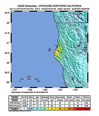
The 2010 Eureka earthquake occurred on January 9 at 4:27:38 pm PST offshore of Humboldt County, California, United States. The magnitude was measured 6.5 on the scale, and its epicenter was located offshore in the Pacific Ocean 33 miles (53 km) west of the nearest major city, Eureka. Additionally, there was a separate earthquake further offshore of Eureka on February 4 with a slightly lower magnitude of 5.9. It was also the most significant earthquake in the Eureka area in terms of magnitude since the 1992 Cape Mendocino earthquakes. It was felt from Santa Cruz County, California in the south, to Eugene, Oregon in the north and to the east as far as Reno, Nevada.
The 1982 North Yemen earthquake hit near the city of Dhamar, North Yemen on December 13. Measuring 6.2 on the moment magnitude scale, with a maximum perceived intensity of VIII (Severe) on the Mercalli intensity scale, as many as 2,800 people were killed and another 1,500 injured. The shock occurred within several hundred kilometers of a plate boundary in a geologically complex region that includes active volcanoes and seafloor spreading ridges. Yemen has a history of destructive earthquakes, though this was the first instrumentally recorded event to be detected on global seismograph networks.
The 1986 Chalfant Valley earthquake struck southern Mono County near Bishop and Chalfant, California at Pacific Daylight Time on July 21. With a moment magnitude of 6.2 and a maximum Mercalli intensity of VI (Strong), the shock injured two people and caused property damage estimated at $2.7 million in the affected areas. There was a significant foreshock and aftershock sequence that included a few moderate events, and was the last in a series of three earthquakes that affected southern California and the northern Owens Valley in July 1986.
The Brawley Seismic Zone (BSZ), also known as the Brawley fault zone, is a predominantly extensional tectonic zone that connects the southern terminus of the San Andreas Fault with the Imperial Fault in Southern California. The BSZ is named for the nearby town of Brawley in Imperial County, California, and the seismicity there is characterized by earthquake swarms.
The 1940 El Centro earthquake occurred at 21:35 Pacific Standard Time on May 18 in the Imperial Valley in southeastern Southern California near the international border of the United States and Mexico. It had a moment magnitude of 6.9 and a maximum perceived intensity of X (Extreme) on the Mercalli intensity scale. It was the first major earthquake to be recorded by a strong-motion seismograph located next to a fault rupture. The earthquake was characterized as a typical moderate-sized destructive event with a complex energy release signature. It was the strongest recorded earthquake in the Imperial Valley, causing widespread damage to irrigation systems and killing nine people.
The 1948 Desert Hot Springs earthquake occurred on December 4 at 3:43 p.m. Pacific Standard Time with a moment magnitude of 6.4 and a maximum Mercalli intensity of VII. The shock was felt from the central coast of California in the north, and to Baja California in the south, and came at a time when earthquake research in southern California resumed following the Second World War. It was one of two events in the 20th century that have occurred near a complex region of the southern San Andreas Fault system where it traverses the San Gorgonio Pass and the northern Coachella Valley. Damage was not severe, but some serious injuries occurred, and aftershocks continued until 1957.
The 1979 Imperial Valley earthquake occurred at 16:16 Pacific Daylight Time on 15 October just south of the Mexico–United States border. It affected Imperial Valley in Southern California and Mexicali Valley in northern Baja California. The earthquake had a relatively shallow hypocenter and caused property damage in the United States estimated at US$30 million. The irrigation systems in the Imperial Valley were badly affected, but no deaths occurred. It was the largest earthquake to occur in the contiguous United States since the 1971 San Fernando earthquake eight years earlier.

The 1943 Alahan Panjang earthquakes occurred on June 8 and June 9 UTC in Sumatra, then under Japanese occupation. This was an earthquake doublet.
The 1979 Coyote Lake earthquake occurred at on August 6 with a moment magnitude of 5.7 and a maximum Mercalli Intensity of VII. The shock occurred on the Calaveras Fault near Coyote Lake in Santa Clara County, California and resulted in a number of injuries, including some that required hospitalization. Most of the $500,000 in damage that was caused was non-structural, but several businesses were closed for repairs. Data from numerous strong motion instruments was used to determine the type, depth, and extent of slip. A non-destructive aftershock sequence that lasted throughout the remainder of the month was of interest to seismologists, especially with regard to fault creep, and following the event local governments evaluated their response to the incident.
The 1892 Vacaville–Winters earthquakes occurred in northern California as a large doublet on April 19 and April 21. Measured on a seismic scale that is based on an isoseismal map or the event's felt area, the 6.4 and 6.2 Mla events were assigned a maximum Mercalli intensity of IX (Violent), and affected the North Bay and Central Valley areas. The total damage was estimated to be between $225,000 and 250,000 and one person was killed. No evidence of fault movement on the surface of the ground was observed as a result of either of the strong shocks. Both occurred in the domain of the San Andreas strike-slip system of faults, but their focal mechanism is uncertain.
The 1932 Eureka earthquake occurred on June 6 at along the northern coastal area of California in the United States. With a moment magnitude of 6.4 and a maximum Mercalli intensity of VIII (Severe), this earthquake left one person dead from a falling chimney and several injured. The shock was the largest in the area since 1923 and was felt in southern Oregon and northern California.
The 1838 San Andreas earthquake is believed to be a rupture along the northern part of the San Andreas Fault in June 1838. It affected approximately 100 km of the fault, from the San Francisco Peninsula to the Santa Cruz Mountains. It was a strong earthquake, with an estimated moment magnitude of 6.8 to 7.2, making it one of the largest known earthquakes in California. The region was lightly populated at the time, although structural damage was reported in San Francisco, Oakland, and Monterey. It is unknown whether there were fatalities. Based on geological sampling, the fault created approximately 1.5 meters of slip.
The 1974 Lesser Antilles earthquake occurred at on October 8 with a moment magnitude of 6.9 and a maximum Mercalli intensity of VIII (Severe). Four people were injured in what the United States' National Geophysical Data Center called a moderately destructive event.
The 1987 Superstition Hills and Elmore Ranch earthquakes were a pair of earthquakes measuring Mw 6.0 and 6.5 that rattled the Imperial Valley of California. The earthquakes caused damage in Southern California and Mexico, but was limited due to their location in a sparsely populated area. It was felt as far as Las Vegas and Phoenix. More than 90 were injured, and two people were killed in Mexico.
The 1968 Borrego Mountain earthquake occurred on April 8, at 18:28 PST in the geologically active Salton Trough of Southern California. The Salton Trough represents a pull-apart basin formed by movements along major faults. This region is dominated by major strike-slip faults one of them being the San Jacinto Fault which produced the 1968 earthquake. The mainshock's epicenter was near the unincorporated community of Ocotillo Wells in San Diego County. The moment magnitude (Mw ) 6.6 strike-slip earthquake struck with a focal depth of 11.1 km (6.9 mi). The zone of surface rupture was assigned a maximum Modified Mercalli intensity (MMI) of VII.
The 1899 San Jacinto earthquake occurred on Christmas morning at 04:25 local time in Southern California. The estimated moment magnitude 6.7 earthquake had an epicenter located 10 miles southeast of San Jacinto. The earthquake had a maximum Mercalli intensity of IX (Violent). Severe damage occurred, amounting to US$50,000, as well as six fatalities.
The 1915 Imperial Valley earthquakes were two destructive shocks centered near El Centro, California on June 22. The earthquakes measured 6.25 and occurred nearly one hour apart at 19:59 and 20:57 PST. Both shocks were assigned VIII (Severe) on the Modified Mercalli intensity scale. Heavy damage occurred in the areas of Mexicali and El Centro, amounting to $900,000. At least six people were killed in the earthquakes.

