An earthquake occurred on July 17, 2006 at along a subduction zone off the coast of west and central Java, a large and densely populated island in the Indonesian archipelago. The shock had a moment magnitude of 7.7 and a maximum perceived intensity of IV (Light) in Jakarta, the capital and largest city of Indonesia. There were no direct effects of the earthquake's shaking due to its low intensity, and the large loss of life from the event was due to the resulting tsunami, which inundated a 300 km (190 mi) portion of the Java coast that had been unaffected by the earlier 2004 Indian Ocean earthquake and tsunami that was off the coast of Sumatra. The July 2006 earthquake was also centered in the Indian Ocean, 180 kilometers (110 mi) from the coast of Java, and had a duration of more than three minutes.
The 1991 Racha earthquake occurred in the province of Racha, Georgia, at 9:12 UTC on 29 April. Centered on the districts of Oni and Ambrolauri on the southern foothills of the Greater Caucasus mountains, it killed 270, left approximately 100,000 homeless and caused severe damage, including to several medieval monuments. It had a magnitude of 7.0 and was the most powerful earthquake recorded in the Caucasus.

The 1707 Hōei earthquake struck south-central Japan at 14:00 local time on 28 October. It was the largest earthquake in Japanese history until it was surpassed by the 2011 Tōhoku earthquake. It caused moderate-to-severe damage throughout southwestern Honshu, Shikoku and southeastern Kyūshū. The earthquake, and the resulting destructive tsunami, caused more than 5,000 casualties. This event ruptured all of the segments of the Nankai megathrust simultaneously, the only earthquake known to have done this, with an estimated magnitude of 8.6 or 8.7 . It possibly also triggered the last eruption of Mount Fuji 49 days later.

The 1993 southwest-off Hokkaido earthquake or Okushiri earthquake occurred at 13:17:12 UTC on 12 July 1993 in the Sea of Japan near the island of Hokkaido. It had a magnitude of 7.7 on the moment magnitude scale and a maximum felt intensity of VIII (Severe) on the Mercalli intensity scale. It triggered a major tsunami that caused deaths on Hokkaidō and in southeastern Russia, with a total of 230 fatalities recorded. The island of Okushiri was hardest hit, with 165 casualties from the earthquake, the tsunami and a large landslide.
An earthquake occurred on 1 June 1786 in and around Kangding, in what is now China's Sichuan province. It had an estimated magnitude of about 7.75 and a maximum perceived intensity of X (Extreme) on the Mercalli intensity scale. The initial quake killed 435 people. After an aftershock ten days later, a further 100,000 died when a landslide dam collapsed across the Dadu river.
The 1979 Bali earthquake occurred at with a surface wave magnitude of 6.3. The shock occurred southeast of the coast of Karangasem Regency in the Lombok Strait, and about 60 kilometres (37 mi) east-northeast of Denpasar. Up to 80 percent of the buildings in Karangasem Regency were damaged, between 15,000 and 500,000 people were displaced, and road links to the provincial capital of Denpasar were briefly severed.
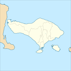
The 1976 Bali earthquake occurred at with a surface wave magnitude of 6.5. The shock occurred 5 kilometres (3.1 mi) south of the Bali Sea coast of the Buleleng Regency, and about 65 kilometres (40 mi) northwest of Denpasar. Up to ninety percent of houses in Buleleng Regency were seriously damaged or destroyed and the Seririt sub-district was almost completely destroyed, where a school building collapsed and trapped at least 200 students. 573 people are believed to have died; at least 544 in Buleleng Regency, 24 in Jembrana and 5 in Tabanan. Four thousand more suffered injuries and an estimated 450,000 were left temporarily homeless.
The 1912 Maymyo earthquake or Burma earthquake struck Burma on the morning of May 23, with an epicentre near Taunggyi and Pyin Oo Lwin in Shan State. The earthquake was initially calculated at 8.0 on the surface wave magnitude scale (Ms ) by Beno Gutenberg and Charles Francis Richter, and described by them as being one of the most remarkable seismic events in the early 1900s. Recent re-evaluation of the earthquake, however, have revised the magnitude to 7.6–7.9. It was preceded by two foreshocks on May 18 and 21 with respective intensities V and VII on the Rossi–Forel scale, while the mainshock was assigned IX. Shaking was felt throughout most of Burma, parts of Siam and Yunnan; an area covering approximately 375,000 square miles. It was one of the largest earthquakes in the country.
The western coast of West Sulawesi was struck by a major earthquake on 23 February 1969 at 00:36 UTC. It had a magnitude of 7.0 and a maximum felt intensity of VIII on the Modified Mercalli intensity scale. It triggered a major tsunami that caused significant damage along the coast of the Makassar Strait. At least 64 people were killed, with possibly a further 600 deaths caused by the tsunami.
The 1674 Ambon earthquake occurred on February 17 between 19:30 and 20:00 local time in the Maluku Islands. The resulting tsunami reached heights of up to 100 metres (330 ft) on Ambon Island killing over 2,000 individuals. It was the first detailed documentation of a tsunami in Indonesia and the largest ever recorded in the country. The exact fault which produced the earthquake has never been determined, but geologists postulate either a local fault, or a larger thrust fault offshore. The extreme tsunami was likely the result of a submarine landslide.
The 1852 Banda Sea earthquake struck on 26 November at 07:40 local time, affecting coastal communities on the Banda Islands. It caused violent shaking lasting five minutes, and was assigned XI on the Modified Mercalli intensity scale in the Maluku Islands. A tsunami measuring up to 8 m (26 ft) slammed into the islands of Banda Neira, Saparua, Haruku and Ceram. The tsunami caused major damage, washing away many villages, ships and residents. At least 60 people were killed in the earthquake and tsunami. The earthquake had an estimated moment magnitude of 7.5 or 8.4–8.8, according to various academic studies.
On the morning of January 5, 1699, a violent earthquake rocked the then Dutch East Indies city of Batavia on the island of Java, now known as the Indonesian capital city of Jakarta. Dutch accounts of the event described the earthquake as being "so heavy and strong" and beyond comparable to other known earthquakes. This event was so large that it was felt throughout west Java, and southern Sumatra.
The 2021 Luxian earthquake was a damaging seismic event occurring in the early hours of September 16 at 04:33 China Standard Time. The surface wave magnitude (Ms ) 6.0 or moment magnitude (Mw ) 5.4 earthquake struck at a shallow depth of 7.5 km and severe shaking in an area of 4,000 square kilometers was assigned a maximum intensity of VIII on the China seismic intensity scale. Three people were killed and 146 injured when the earthquake struck Lu County, Luzhou, Sichuan Province. At least 36,800 buildings were affected, 7,800 of them seriously damaged or completely destroyed, causing about a quarter of a billion dollars worth of damage.
The 1815 Bali earthquake occurred on November 22 between 22:00 and 23:00 local time (WITA), affecting the Bali Kingdom. The estimated moment magnitude 7.0 earthquake struck off the north coast of Bali at a shallow depth. It was assigned a maximum intensity of IX (Violent) on the Mercalli intensity scale, causing severe damage in Buleleng and Tabanan. The earthquake caused a landslide and tsunami that killed 11,453 people.
The 2021 Bali earthquake struck at 04:18 local time (UTC+08:00) when people were still sleeping on 15 October 2021. It resulted in 4 deaths and 73 more injured, despite having a moment magnitude of 4.7.

An earthquake occurred 112 km, offshore, north of Maumere in the Flores Sea on December 14. The quake had a moment magnitude of 7.3 according to the United States Geological Survey (USGS). One person was killed and 173 others suffered injuries.
The 1843 Nias earthquake off the northern coast of Sumatra, Indonesia caused severe damage when it triggered a tsunami along the coastline. The earthquake with a moment magnitude (Mw ) of 7.8 lasted nine minutes, collapsing many homes in Sumatra and Nias. It was assigned a maximum modified Mercalli intensity of XI (Extreme).
The 1858 Prome earthquake occurred on August 24 at 15:38 local time in British Burma. The earthquake occurred with a magnitude of 7.6–8.3 on the moment magnitude scale. It had an epicenter in near the city of Pyay (Prome), Bago. The shock was felt with a maximum Modified Mercalli intensity of XI (Extreme) for about one minute. Severe damage was reported in Bago, and off the coast of Rakhine, an island sunk.

The 1867 Central Java earthquake occurred on June 10 at between 04:20 and 04:30 local time. It struck off the southern coast of the Indonesian island with an estimated moment magnitude of 7.8 (Mw ). Widespread devastation occurred in Central Java, where as many as 700 people were killed. The intermediate-depth intraslab earthquake did not cause a tsunami.
An earthquake affected the island of Java, Indonesia on 22 January 1780. The source and magnitude of the earthquake remains debated among seismologists. Proposed origins of the earthquake include shallow inland back-arc thrusting along a fault located within the upper crust on the island or rupture of the subduction zone off the southern coast of Java. The magnitude of the earthquake is estimated to be at least 8.5, while other sources usually refer to it with a range of Mw 8.0 to 8.5 for the megathrust earthquake. For the shallow crustal earthquake source, the magnitude range is Mw 7.0 to 8.0.
 Collapsed houses after the earthquake in Bali
 Collapsed houses after the earthquake in Bali
 Collapsed houses after the earthquake in Bali
 Collapsed houses after the earthquake in Bali
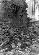 Collapsed building after the earthquake in Bali