The 1979 Bali earthquake occurred at with a surface wave magnitude of 6.3. The shock occurred southeast of the coast of Karangasem Regency in the Lombok Strait, and about 60 kilometres (37 mi) east-northeast of Denpasar. Up to 80 percent of the buildings in Karangasem Regency were damaged, between 15,000 and 500,000 people were displaced, and road links to the provincial capital of Denpasar were briefly severed.
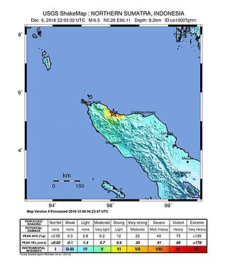
The 2016 Aceh earthquake struck the Indonesian island of Sumatra with a Mw of 6.5 in Aceh province on 7 December 2016, at 05:03 WIB. The shock was reported to be at a depth of 13 km, categorized as a strong, shallow earthquake. The epicentre was located near the village of Reuleut in Pidie Jaya Regency, 164 km (102 mi) southeast of the province's capital, Banda Aceh. 104 people died in the quake, with at least 1,000 people injured. It was the deadliest earthquake in Aceh since the 2005 Nias–Simeulue earthquake and the deadliest in Sumatra since the 2010 Mentawai earthquake and tsunami.

The 2017 Java earthquake occurred on 15 December 2017 when a moment magnitude 6.5 earthquake struck the Indonesian island of Java, specifically the city of Tasikmalaya on 23:47:58 West Indonesian Time in West Java, Indonesia. The earthquake struck at a depth of 91 km and was categorized as a strong but deep earthquake. It was initially registered as a 7.3 magnitude earthquake by Indonesian agencies. Widespread damage was reported across Tasikmalaya, the nearest major city to the epicentre. A tsunami warning was immediately issued by the authorities but was subsequently cancelled. Four people have been confirmed dead.

A Mw 6.4 earthquake struck the island of Lombok on the morning of 29 July 2018 at a shallow depth of 14 km (8.7 mi). Widespread damage was reported in the area, and authorities confirmed that 20 people were killed in the earthquake while hundreds were injured.
On 5 August 2018, a destructive and shallow earthquake measuring Mw 6.9 struck the island of Lombok, Indonesia. It was the main shock following its foreshock, a nearby Mw 6.4 earthquake on 29 July. It was followed by a nearby 6.9 earthquake on 19 August 2018.

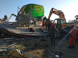
On 28 September 2018, a shallow, large earthquake struck in the neck of the Minahasa Peninsula, Indonesia, with its epicentre located in the mountainous Donggala Regency, Central Sulawesi. The magnitude 7.5 quake was located 70 km (43 mi) away from the provincial capital Palu and was felt as far away as Samarinda on East Kalimantan and also in Tawau, Malaysia. This event was preceded by a sequence of foreshocks, the largest of which was a magnitude 6.1 tremor that occurred earlier that day.

On 11 October 2018, an earthquake struck off the coast of East Java, Indonesia, with the epicentre located off the coast of Situbondo Regency. The earthquake, which struck at dawn, killing four people in addition to destroying or damaging hundreds of houses, mostly on the small island of Sapudi.
On 17 March 2019, an earthquake measuring Mw 5.6 struck the island of Lombok in West Nusa Tenggara, Indonesia. The earthquake triggered a landslide, killing six and injuring nearly 200 others.

The 2019 North Maluku earthquake, a shallow 7.2 magnitude earthquake, struck the island of Halmahera, North Maluku, Indonesia on 14 July 2019 at 18:10 local time with its epicentre located at South Halmahera. It struck at a shallow depth of 10 km (6.2 mi) near Labuha, a small port town located in Bacan Island. The earthquake produced a non-destructive 20 cm tsunami, which struck Labuha just minutes after the shaking started. 14 people were killed by the earthquake while 129 people were injured, and more than 50,000 people were displaced. The earthquake inflicted a total damage of Rp 238 billion.
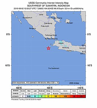
The 2019 Sunda Strait earthquake occurred on the night of 2 August 2019, when a magnitude 6.9 earthquake rattled Sunda Strait at a moderate depth of 52.8 kilometres. The epicentre was located 214 km from Bandar Lampung, the capital of Lampung and 147 km west of Sumur, Pandeglang Regency. The earthquake struck with a maximum intensity of VI (Strong). The earthquake prompted a tsunami warning in the area, with authorities urging coastal residents to immediately evacuate to higher grounds.

On 26 September 2019, a strong magnitude 6.5 earthquake struck Seram Island in Maluku, Indonesia, near the provincial capital of Ambon. The earthquake struck at 07:46:44 Eastern Indonesia Time with a shallow depth of 18 km. The tremor could be felt throughout the island, with an intensity of very strong (VII) reportedly felt in the provincial capital of Ambon.
A moment magnitude 6.2 earthquake struck Majene Regency in West Sulawesi, Indonesia, on 15 January 2021, at 02:28 WITA. The reverse faulting shock initiated at 18.0 km (11.2 mi) depth with an epicenter inland, located 32 km (20 mi) south of Mamuju. It was preceded by a Mw 5.7 foreshock several hours prior. Shaking from the mainshock was assigned a maximum Modified Mercalli intensity of VI (Strong) in Majene and Mamuju. Four of the five regencies in West Sulawesi were affected. More than 6,000 structures were damaged or destroyed; damage was estimated at Rp829.1 billion rupiah. At least 105 people were confirmed dead; more than 3,300 were injured and thousands were displaced.
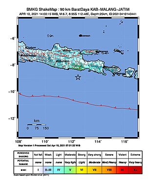
An earthquake occurred on 10 April 2021 at 14:00 local time (UTC+07:00) off the south coast of eastern Java. The epicenter of the earthquake is located 44 km south southwest of Gondanglegi Kulon in East Java province. Measuring 6.0 or 6.1 on the moment magnitude scale (Mw ) and having a depth of 82.3 km, the earthquake caused moderate shaking measuring V on the Mercalli intensity scale. At least 10 individuals are known to have died from the earthquake and another 104 were seriously injured.
The 1815 Bali earthquake occurred on November 22 between 22:00 and 23:00 local time (WITA), affecting the Bali Kingdom. The estimated moment magnitude 7.0 earthquake struck off the north coast of Bali at a shallow depth. It was assigned a maximum intensity of IX (Violent) on the Mercalli intensity scale, causing severe damage in Buleleng and Tabanan. The earthquake caused a landslide and tsunami that killed 11,453 people.
The 2021 Bali earthquake struck at 04:18 local time (UTC+08:00) when people were still sleeping on 15 October 2021. It resulted in 4 deaths and 73 more injured, despite having a moment magnitude of 4.7.

An earthquake occurred 112 km, offshore, north of Maumere in the Flores Sea on December 14. The quake had a moment magnitude of 7.3 according to the United States Geological Survey (USGS). One person was killed and 173 others suffered injuries.
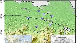
The Baribis Fault is a geological feature located in the northern part of Java. This fault, estimated to be 100 kilometers long, stretches from Purwakarta to Lebak Regency and is a threat to the Jakarta metropolitan area because the fault is partially located within the metropolitan area itself.

On 21 November 2022, at 13:21 WIB (UTC+07:00), a 5.6 earthquake struck near Cianjur in West Java, Indonesia. The strike-slip earthquake occurred with a focal depth of 11 km (6.8 mi). Between 335 and 635 people died, 7,729 were injured and five remain missing. More than 62,628 homes were damaged across 16 districts in Cianjur Regency and the surrounding region. It is the deadliest earthquake to hit Indonesia since the 2018 Sulawesi earthquake. Damage evaluated after the event earned it a maximum Modified Mercalli intensity of VIII (Severe).
A moment magnitude 7.6 earthquake struck offshore near the Tanimbar Islands, Maluku, Indonesia, at a depth of 105.1 km, on 10 January 2023.