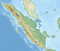
The Indonesian island of Sumatra is located in a highly seismic area of the world. In addition to the subduction zone off the west coast of the island, Sumatra also has a large strike-slip fault, the Great Sumatran Fault also known as Semangko Fault, running the entire length of the island. This fault zone accommodates most of the strike-slip motion associated with the oblique convergence between the Indo-Australian and Eurasian plates. The fault ends in the north just below the city of Banda Aceh, which was devastated in the 2004 Indian Ocean earthquake. After the December 2004 earthquake, pressure on the Great Sumatran Fault has increased tremendously, especially in the north.

The 2006 Yogyakarta earthquake occurred at with a moment magnitude of 6.4 and a maximum MSK intensity of VIII (Damaging). Several factors led to a disproportionate amount of damage and number of casualties for the size of the shock, with more than 5,700 dead, tens of thousands injured, and financial losses of Rp 29.1 trillion. With limited effects to public infrastructure and lifelines, housing and private businesses bore the majority of damage, and the United States' National Geophysical Data Center classified the total damage from the event as extreme.

Central Aceh Regency is a regency in Aceh Special Region of Indonesia. It is located on Sumatra island. Formerly this regency covered a much larger area; in 1969, the Southeast Aceh Regency was separated from the Central Aceh Regency, and in 2003 the Bener Meriah Regency was separated from the remaining Central Aceh Regency. The remaining regency covers an area of 4,468.42 square kilometres and had a population of 175,527 according to the 2010 census, which rose to 215,576 at the 2020 Census; the official estimate as at mid 2021 was 222,673 - comprising 112,900 males and 109,773 females. Most of its inhabitants are Gayo. Central Aceh is famous for its Lake Laut Tawar. Its capital is Takengon, in Lut Tawar District.
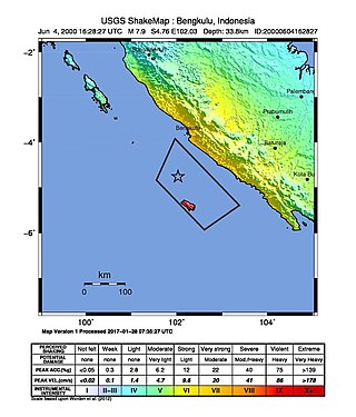
The 2000 Enggano earthquake struck at 23:28 local time on June 4 with a moment magnitude of 7.9 and a maximum Mercalli intensity of VI (Strong). The event occurred off the coast of southern Sumatra, Indonesia near Enggano Island. There were more than 100 fatalities and up to 2,585 injuries. Over 730 aftershocks shook the area afterwards, one just eleven minutes after the mainshock.

The first of the 2009 Sumatra earthquakes occurred on 30 September off the coast of Sumatra, Indonesia with a moment magnitude of 7.6 at . The epicenter was 45 kilometres (28 mi) west-northwest of Padang, West Sumatra, and 220 kilometres (140 mi) southwest of Pekanbaru, Riau. Government and authorities confirmed 1,115 dead, 1,214 severely injured and 1,688 slightly injured. The most deaths occurred in the areas of Padang Pariaman (675), Padang (313), Agam (80) and Pariaman (37). In addition, around 135,000 houses were severely damaged, 65,000 houses were moderately damaged and 79,000 houses were slightly damaged. An estimated 250,000 families have been affected by the earthquake through the total or partial loss of their homes and livelihoods.
The 2011 Tarlay earthquake occurred on 24 March in Shan State, Myanmar. The earthquake measured 6.8 and had an epicenter northwest of the border between Myanmar, Thailand and Laos. It occurred in a region accommodating tectonic deformation brought by the collision between the Indo-Australian and Eurasian plates. Strike-slip faulting along the Nan Ma Fault was identified as the cause. There were between 75 and 151 fatalities; including one death in Thailand. An additional 212 people were injured. Hundreds of buildings and some transport infrastructure were damaged in Myanmar and Thailand. In the aftermath of the disaster, the Burmese government provided aid and relief supplies to the affected region. Neighbouring countries China, India and Thailand provided monetary assistance. Several international humanitarian organizations also supported in the relief and recovery.
The 2012 Indian Ocean earthquakes were magnitude 8.6 and 8.2 Mw undersea earthquakes that struck near the Indonesian province of Aceh on 11 April at 15:38 local time. Initially, authorities feared that the initial earthquake would cause a tsunami and warnings were issued across the Indian Ocean; however, these warnings were subsequently cancelled. These were unusually strong intraplate earthquakes and the largest strike-slip earthquake ever recorded.
The 1994 Liwa earthquake occurred on . It was located in southern Sumatra, Indonesia. The magnitude of the earthquake was put at 6.9, Mw 7.0, or 7.2, according to different sources.

The 2016 Sumatra earthquake was a 7.8 magnitude earthquake which struck on 2 March 2016 in the Indian Ocean, approximately 800 kilometers southwest of Sumatra in Indonesia. Tsunami warnings were issued for Indonesia and Australia, but were withdrawn two hours later. There were no deaths directly related to the earthquake.
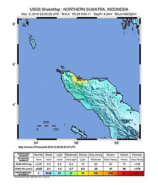
The 2016 Aceh earthquake struck the Indonesian island of Sumatra with a Mw of 6.5 in Aceh province on 7 December 2016, at 05:03 WIB. The shock was reported to be at a depth of 13 km, categorized as a strong, shallow earthquake. The epicentre was located near the village of Reuleut in Pidie Jaya Regency, 164 km (102 mi) southeast of the province's capital, Banda Aceh. 104 people died in the quake, with at least 1,000 people injured. It was the deadliest earthquake in Aceh since the 2005 Nias–Simeulue earthquake and the deadliest in Sumatra since the 2010 Mentawai earthquake and tsunami.
On 4 May 2000 at 12:21 WITA, Banggai Islands Regency was hit by an earthquake of magnitude 7.5 , followed by a tsunami. The Banggai Islands, an archipelago located at the far eastern end of Central Sulawesi, Indonesia, was the worst affected by the earthquake. Eighty percent of Banggai's buildings were destroyed. Damage also occurred on Peleng. The earthquake triggered a local tsunami of up to 6 m in height that caused significant damage east of Luwuk on the mainland and on Peleng.
A moment magnitude 6.2 earthquake struck Majene Regency in West Sulawesi, Indonesia, on 15 January 2021, at 02:28 WITA. The reverse faulting shock initiated at 18.0 km (11.2 mi) depth with an epicenter inland, located 32 km (20 mi) south of Mamuju. It was preceded by a Mw 5.7 foreshock several hours prior. Shaking from the mainshock was assigned a maximum Modified Mercalli intensity of VI (Strong) in Majene and Mamuju. Four of the five regencies in West Sulawesi were affected. More than 6,000 structures were damaged or destroyed; damage was estimated at Rp829.1 billion rupiah. At least 105 people were confirmed dead; more than 3,300 were injured and thousands were displaced.

On February 20, 2008, an earthquake with a moment magnitude of 7.4 struck off the coast of Sumatra at a hypocentre depth of 26 km. The earthquake had an epicenter located on the island of Simeulue, northwest from Sinabang, a small town on the island. Three people were killed and an additional 25 seriously injured as a result of the earthquake.
The 1995 Kerinci earthquake struck near Sungai Penuh in Jambi Province on the island of Sumatra, Indonesia. It earthquake occurred at 01:18 WIB local time on October 7. The earthquake measured 6.7 on the moment magnitude scale, and 6.9–7.0 on the surface wave magnitude scale. Between 84 and possibly even 100 people were killed in the earthquake. An extimated 4,000 buildings collapsed or were seriously damaged while a further 5,000 suffered some damage.
On August 12, 2021, at 01:46:12 PST, a strong Mw 7.1 earthquake struck the island of Mindanao at a depth of 56.7 kilometers (35.2 mi). It perceived Intensity V on the PHIVOLCS Earthquake Intensity Scale. No damage or injuries were reported but a young man was killed by the earthquake.
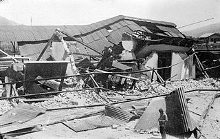
West Sumatra, Dutch East Indies was struck by an earthquake doublet on June 28, 1926. The first earthquake occurred at 10:23 local time, with an estimated magnitude of 6.7 on the surface wave magnitude scale with an intensity of IX (Violent) on the Modified Mercalli Intensity Scale. Less than three hours later, a second earthquake occurred with a magnitude of 6.4 Ms although it appears to have been less damaging. Three hundred and fifty-four people were killed during the first earthquake, with later shocks killing a total of 57 according to local records.

An earthquake occurred 112 km, offshore, north of Maumere in the Flores Sea on December 14. The quake had a moment magnitude of 7.3 according to the United States Geological Survey (USGS). One person was killed and 173 others suffered injuries.

On 25 February 2022 at 08:39 WIB, a moment magnitude (Mw ) 6.2 earthquake struck West Sumatra, Indonesia at a depth of 4.0 km (2.5 mi). Preceded by one foreshock and followed by over 200 aftershocks, the mainshock had an epicenter at the foot of Mount Talakmau in Pasaman Regency. The mainshock was the result of strike-slip faulting along a previously unidentified segment of the Great Sumatran Fault. At least 27 people died, 457 were injured, and 19,221 others were displaced. It inflicted 780 million Indonesian rupiahs (Rp) worth of damage. The heaviest damage was recorded at three villages around Mount Talakmau. Landslides and flash floods caused additional damage and casualties.
The 1933 Sumatra earthquake or Liwa earthquake occurred in West Lampung Regency, Lampung Province, Indonesia on June 25. The earthquake had an estimated surface-wave magnitude (Ms ) of 7.7 occurring at a shallow depth of 20 km. It had an epicenter onshore, devastating the city of Liwa. At least 76 people were reported killed, although the death toll may have been in the thousands. Aftershocks followed, including one which was strong enough to cause additional fatalities. The mainshock also triggered a nearby volcanic eruption two weeks later, killing some people.