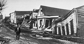
The 1960 Valdivia earthquake and tsunami or the Great Chilean earthquake on 22 May 1960 was the most powerful earthquake ever recorded. Various studies have placed it at 9.4–9.6 on the moment magnitude scale. It occurred in the afternoon, and lasted for approximately 10 minutes. The resulting tsunamis affected southern Chile, Hawaii, Japan, the Philippines, eastern New Zealand, southeast Australia, and the Aleutian Islands.

Simeulue Regency is a regency in the Aceh special region of Indonesia. It occupies the whole island of Simeulue, 150 km off the west coast of Sumatra, with an area of 1,838.10 square kilometres. It had a population of 80,674 at the 2010 census and 92,865 at the 2020 census; the official estimate as at mid 2023 was 97,118.

Many major earthquakes have occurred in the region of the Kamchatka Peninsula in far eastern Russia. Events in 1737, 1923 and 1952, were megathrust earthquakes and caused tsunamis. There are many more earthquakes and tsunamis originating from the region.

The Fukuoka earthquake struck Fukuoka Prefecture, Japan at 10:53 am JST on March 20, 2005, and lasted for approximately 1 minute. The Japan Meteorological Agency (JMA) measured it as peaking at a magnitude of 7.0, whereas the United States Geological Survey (USGS) reported a magnitude of 6.6. The quake occurred along a previously unknown fault in the Genkai Sea, North of Fukuoka city, and the residents of Genkai Island were forced to evacuate as houses collapsed and landslides occurred in places. Investigations subsequent to the earthquake determined that the new fault was most likely an extension of the known Kego fault that runs through the centre of the city.

The seismicity of the Sanriku coast identifies and describes the seismic activity of an area of Japan. Seismicity refers to the frequency, type and size of earthquakes experienced over a period of time. The Sanriku Coast is a descriptive term referring to the coastal areas of the former provinces of Rikuō in Aomori, Rikuchū in Aomori, and Rikuzen in Miyagi.

The September 2007 Sumatra earthquakes were a series of megathrust earthquakes that struck the Sunda Trench off the coast of Sumatra, Indonesia, with three of magnitude 7 or greater. A series of tsunami bulletins was issued for the area. The most powerful of the series had a magnitude of 8.5, which makes it in the top 20 of the largest earthquakes ever recorded on a seismograph.
Mount Breakenridge, 2,395 m or 7,858 ft, is a mountain in the Lillooet Ranges of southwestern British Columbia, Canada, located on the east side of upper Harrison Lake in the angle of mountains formed by that lake and the Big Silver River.

The 1958 Lituya Bay earthquake occurred on PST with a moment magnitude of 7.8 to 8.3 and a maximum Mercalli intensity of XI (Extreme). The strike-slip earthquake took place on the Fairweather Fault and triggered a rockslide of 30 million cubic meters and about 90 million tons into the narrow inlet of Lituya Bay, Alaska. The impact was heard 80 kilometers (50 mi) away, and the sudden displacement of water resulted in a megatsunami that washed out trees to a maximum elevation of 524 meters at the entrance of Gilbert Inlet. This is the largest and most significant megatsunami in modern times; it forced a re-evaluation of large-wave events and the recognition of impact events, rockfalls, and landslides as causes of very large waves.

The 2010 Chile earthquake and tsunami occurred off the coast of central Chile on Saturday, 27 February at 03:34:12 local time, having a magnitude of 8.8 on the moment magnitude scale, with intense shaking lasting for about three minutes. It was felt strongly in six Chilean regions that together make up about 80 percent of the country's population. According to the United States Geological Survey (USGS) the cities experiencing the strongest shaking—VIII (Severe) on the Mercalli intensity scale (MM)—were Concepción, Arauco, and Coronel. According to Chile's Seismological Service, Concepción experienced the strongest shaking at MM IX (Violent). The earthquake was felt in the capital Santiago at MM VII or MM VIII. Tremors were felt in many Argentine cities, including Buenos Aires, Córdoba, Mendoza, and La Rioja. Tremors were felt as far north as the city of Ica in southern Peru. It is the largest earthquake to hit Chile since the 1960 Valdivia earthquake.
The 1965 Ceram Sea earthquake occurred on January 24 at 00:11 UTC with a moment magnitude of 8.2 and its epicenter was located just off the southwestern coast of Sanana Island in eastern Indonesia. The event occurred at a depth of 28 kilometers under the Ceram Sea, and a tsunami was generated which caused damage in Sanana, Buru, and Mangole. During the tsunami three consecutive run-ups were reported in Seram Island, and a four-meter run-up was reported at Buru Island.
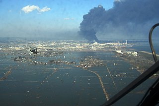
On 11 March 2011, at 14:46 JST, a 9.0–9.1 undersea megathrust earthquake occurred in the Pacific Ocean, 72 km (45 mi) east of the Oshika Peninsula of the Tōhoku region. It lasted approximately six minutes, causing a tsunami. It is sometimes known in Japan as the "Great East Japan Earthquake", among other names. The disaster is often referred to by its numerical date, 3.11.
The 1932 Jalisco earthquakes began on June 3 at 10:36 UTC with a megathrust event that registered 8.1 on the moment magnitude scale. With a maximum perceived intensity of X (Extreme) on the Mercalli intensity scale, at least 400 deaths were caused in Mexico and neighboring Guatemala. It was the first of a series of seismic events that affected parts of western Mexico during the month of June 1932, all reaching magnitude 7 or greater.
The 1989 Irian Jaya earthquake struck Kurima District, Yahukimo Regency, Highland Papua, Indonesia – then Irian Jaya province – on August 1 with a moment magnitude of 6.0 and a maximum Mercalli intensity of VIII (Severe). Around 120 people were killed, mainly due to landslides and mudslides.

The 2016 Sumatra earthquake was a 7.8 magnitude earthquake which struck on 2 March 2016 in the Indian Ocean, approximately 800 kilometers southwest of Sumatra in Indonesia. Tsunami warnings were issued for Indonesia and Australia, but were withdrawn two hours later. There were no deaths directly related to the earthquake.

On 9 December 2016 at 4:38 a.m. local time, the Solomon Islands region was rocked by an Mww 7.8 earthquake, centered 30 km off San Cristobal Island, about 61 km southwest of Kirakira, the capital of Makira-Ulawa Province. Initially registering magnitude 8.0, later downgraded to 7.8, the temblor prompted tsunami warnings that kept countries surrounding the Coral, Tasman and Solomon Sea on high alert, but was later cancelled. A large aftershock of magnitude 6.9 occurred shortly afterwards. This earthquake was largely felt, waking many residents who later ran to high ground for fears of a potential tsunami. The earthquake killed a child and affected some 34,000 people in Makira, South Malaita and Guadalcanal Island where many had lost their homes or had no access to basic needs. Earthquakes are common in this region, with little or no fatalities. This earthquake is tied with three other magnitude 7.8 earthquakes for the second largest earthquake of 2016. On 17 December, the Solomon Islands would be rattled again by a 7.9 magnitude earthquake, this time 54 km east of Taron, Papua New Guinea.

The 2013 Craig, Alaska earthquake struck on January 5, at 12:58 am (UTC–7) near the city of Craig and Hydaburg, on Prince of Wales Island. The Mw 7.5 earthquake came nearly three months after an Mw 7.8 quake struck Haida Gwaii on October 28, in 2012. The quake prompted a regional tsunami warning to British Columbia and Alaska, but it was later cancelled. Due to the remote location of the quake, there were no reports of casualties or damage.

On February 20, 2008, an earthquake with a moment magnitude of 7.4 struck off the coast of Sumatra at a hypocentre depth of 26 km. The earthquake had an epicenter located on the island of Simeulue, northwest from Sinabang, a small town on the island. Three people were killed and an additional 25 seriously injured as a result of the earthquake.
The 1852 Banda Sea earthquake struck on 26 November at 07:40 local time, affecting coastal communities on the Banda Islands. It caused violent shaking lasting five minutes, and was assigned XI on the Modified Mercalli intensity scale in the Maluku Islands. A tsunami measuring up to 8 m (26 ft) slammed into the islands of Banda Neira, Saparua, Haruku and Ceram. The tsunami caused major damage, washing away many villages, ships and residents. At least 60 people were killed in the earthquake and tsunami. The earthquake had an estimated moment magnitude of 7.5 or 8.4–8.8, according to various academic studies.
The 1889 Chilik earthquake occurred on July 11 on the Gregorian calendar, or June 30 on the Julian calendar at 15:14 local time in the Tien Shan mountains. The earthquake measured an estimated Mw 7.9–8.0 on the moment magnitude scale and was assigned a maximum intensity of X (Devastating) on the MSK 64 and Rossi-Forel scales. Over 92 people across Kazakhstan, Kyrgyzstan and China were killed.
The 1657 Concepción earthquake occurred on March 15 at 20:00 local time off the coast of Concepción, Biobío Region in the Spanish Empire. The earthquake caused severe damage along the coast, and generated a large tsunami in the Bay of Concepción. At least 40 people were killed, the majority due to drowning from the tsunami. The town of Concepción was the hardest hit, with the earthquake and tsunami totally destroying it.

