Flores is one of the Lesser Sunda Islands, a group of islands in the eastern half of Indonesia. Including Komodo Island off its west coast, the land area is 15,530.58 km2, and the population was 1,878,875 in the 2020 Census ; the official estimate as of mid-2022 was 1,919,395. The largest towns are Maumere and Ende. The name Flores is of Portuguese origin, meaning "Flowers".

On 26 December 2004, at 07:58:53 local time (UTC+7), a major earthquake with a magnitude of 9.1–9.3 struck with an epicentre off the west coast of northern Sumatra, Indonesia. The undersea megathrust earthquake, known by the scientific community as the Sumatra–Andaman earthquake, was caused by a rupture along the fault between the Burma Plate and the Indian Plate, and reached a Mercalli intensity up to IX in some areas.

The 1946 Aleutian Islands earthquake occurred near the Aleutian Islands, Alaska on April 1, 1946. The shock measured 8.6, 9.3 or 7.4. It had a maximum Mercalli intensity of VI (Strong). It resulted in 165–173 casualties and over US $26 million in damage. The seafloor along the fault was elevated, triggering a Pacific-wide tsunami with multiple destructive waves at heights ranging from 45–138 ft (14–42 m). The tsunami obliterated the Scotch Cap Lighthouse on Unimak Island, Alaska among others, and killed all five lighthouse keepers. Despite the destruction to the Aleutian Island Unimak, the tsunami had almost an imperceptible effect on the Alaskan mainland.

An earthquake occurred on July 17, 2006 at along a subduction zone off the coast of west and central Java, a large and densely populated island in the Indonesian archipelago. The shock had a moment magnitude of 7.7 and a maximum perceived intensity of IV (Light) in Jakarta, the capital and largest city of Indonesia. There were no direct effects of the earthquake's shaking due to its low intensity, and the large loss of life from the event was due to the resulting tsunami, which inundated a 300 km (190 mi) portion of the Java coast that had been unaffected by the earlier 2004 Indian Ocean earthquake and tsunami that was off the coast of Sumatra. The July 2006 earthquake was also centered in the Indian Ocean, 180 kilometers (110 mi) from the coast of Java, and had a duration of more than three minutes.
The 1998 Papua New Guinea earthquake occurred on July 17 with a moment magnitude of 7.0 and a maximum Mercalli intensity of VIII (Severe). The event occurred on a reverse fault near the north coast region of Papua New Guinea, 25 kilometers (16 mi) from the coast near Aitape, and caused a large undersea landslide which caused a tsunami that hit the coast, killing between at least 2,183 and 2,700 people and injuring thousands.
The 1982 Flores earthquake struck the island of Flores in Indonesia on December 25. Registering a moment magnitude of 5.9, according to the International Seismological Centre, it created landslides and was reportedly accompanied by a tsunami. The earthquake killed thirteen people and left 390 injured, also destroying 1,875 houses and 121 other buildings. The villages of Layahong and Oyong Barang were damaged by seven seconds of shaking.
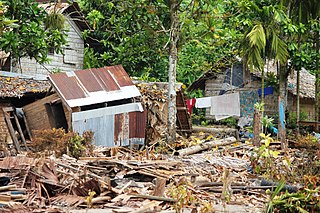
Babi Island is an island located off the coast of Flores, East Nusa Tenggara. The 1992 Flores earthquake and tsunami are estimated to have killed 263 to 700 residents of the island, with most of the destruction on the southern end of the island.
The 2013 Solomon Islands earthquake struck Temotu Province within Solomon Islands on 6 February with a moment magnitude of 8.0 and a maximum Mercalli intensity of VIII (Severe). The epicentre was close to the Santa Cruz Islands within Temotu Province at the boundaries of the Indo-Australian and Pacific tectonic plates, causing local evacuations, a tsunami of 11 m (36 ft) and killing at least ten people.
The 1999 Ambrym earthquake occurred on November 26 at with a moment magnitude of 7.4 and a maximum Mercalli intensity of VII. The back arc thrust event occurred within the Vanuatu archipelago, just to the south of the volcanic island of Ambrym. Vanuatu, which was previously known as New Hebrides, is subject to volcanic and earthquake activity because it lies on an active and destructive plate boundary called the New Hebrides Subduction Zone. While the National Geophysical Data Center classified the total damage as moderate, a destructive local tsunami did result in some deaths, with at least five killed and up to 100 injured.
On 4 May 2000 at 12:21 WITA, Banggai Islands Regency was hit by an earthquake of magnitude 7.5 , followed by a tsunami. The Banggai Islands, an archipelago located at the far eastern end of Central Sulawesi, Indonesia, was the worst affected by the earthquake. Eighty percent of Banggai's buildings were destroyed. Damage also occurred on Peleng. The earthquake triggered a local tsunami of up to 6 m in height that caused significant damage east of Luwuk on the mainland and on Peleng.

The 1812 Ventura earthquake occurred on the morning of December 21 at 11:00 Pacific Standard Time (PST). The 7.1–7.5 magnitude earthquake, with a Modified Mercalli intensity scale rating of X (Extreme), along with its resulting tsunami, caused considerable damage to present-day Santa Barbara and Ventura County, California, which was at the time a territory of the Spanish Empire. One person was killed as a result of the earthquake while another from the aftershock. The earthquake occurred just as the region was recovering from another event on 8 December the same year. Both events are thought to have been related.
On January 1, 1996, at 4:05 p.m. Central Indonesia Time, an earthquake with an epicenter in the Makassar Strait struck north of Minahasa on the island of Sulawesi, Indonesia. The earthquake measured 7.9 on the moment magnitude scale and was centered off Tolitoli Regency in Central Sulawesi, or 25 km from the Tonggolobibi village. A tsunami of 2–4 m (6.6–13.1 ft) was triggered by this earthquake as a result. At least 350 buildings were badly damaged, nine people died and 63 people were injured.

The 1867 Virgin Islands earthquake and tsunami occurred on November 18, at 14.45 in the Anegada Passage about 20 km southwest of Saint Thomas, Danish West Indies. The Ms 7.5 earthquake came just 20 days after the devastating San Narciso Hurricane in the same region. Tsunamis from this earthquake were some of the highest ever recorded in the Lesser Antilles. Wave heights exceeded 10 m (33 ft) in some islands in the Lesser Antilles. The earthquake and tsunami resulted in no more than 50 fatalities, although hundreds of casualties were reported.
The western coast of West Sulawesi was struck by a major earthquake on 23 February 1969 at 00:36 UTC. It had a magnitude of 7.0 and a maximum felt intensity of VIII on the Modified Mercalli intensity scale. It triggered a major tsunami that caused significant damage along the coast of the Makassar Strait. At least 64 people were killed, with possibly a further 600 deaths caused by the tsunami.
The 1852 Banda Sea earthquake struck on 26 November at 07:40 local time, affecting coastal communities on the Banda Islands. It caused violent shaking lasting five minutes, and was assigned XI on the Modified Mercalli intensity scale in the Maluku Islands. A tsunami measuring up to 8 m (26 ft) slammed into the islands of Banda Neira, Saparua, Haruku and Ceram. The tsunami caused major damage, washing away many villages, ships and residents. At least 60 people were killed in the earthquake and tsunami. The earthquake had an estimated moment magnitude of 7.5 or 8.4–8.8, according to various academic studies.
The 1815 Bali earthquake occurred on November 22 between 22:00 and 23:00 local time (WITA), affecting the Bali Kingdom. The estimated moment magnitude 7.0 earthquake struck off the north coast of Bali at a shallow depth. It was assigned a maximum intensity of IX (Violent) on the Mercalli intensity scale, causing severe damage in Buleleng and Tabanan. The earthquake caused a landslide and tsunami that killed 11,453 people.

An earthquake occurred 112 km, offshore, north of Maumere in the Flores Sea on December 14. The quake had a moment magnitude of 7.3 according to the United States Geological Survey (USGS). One person was killed and 173 others suffered injuries.

On September 9, 2002, a magnitude 7.6 earthquake struck off the coast of Wewak, Sandaun Province, Papua New Guinea. The shallow reverse earthquake triggered a local tsunami measuring 5 meters high. The disaster resulted in at least 6 deaths, 70 injuries and building damage.
On 29 November, at 14:10 UTC, a magnitude 7.7 earthquake struck off the southern coast of Taliabu Island Regency in North Maluku, Indonesia. At least 41 people were killed on the nearby islands and a tsunami was triggered. Several hundred homes, buildings and offices were damaged or destroyed.

The 1940 Shakotan earthquake occurred on August 2 at 00:08:22 JST with a moment magnitude (Mw ) of 7.5 and maximum JMA seismic intensity of Shindo 4. The shock had an epicenter off the coast of Hokkaido, Japan. Damage from the shock was comparatively light, but the accomanying tsunami was destructive. The tsunami caused 10 deaths and 24 injuries on Hokkaido, and destroyed homes and boats across the Sea of Japan. The highest tsunami waves were recorded at the coast of Russia while along the coast of Hokkaido, waves were about 2 m.