2006 Pangandaran earthquake and tsunami

Last updated

2006 Pangandaran earthquake and tsunami
Pangandaran - view National Park.JPG
The beach and peninsula encompassing Pangandaran National Park
Indonesia Java relief location map.png
Bullseye1.png
Indonesia relief location map.jpg
Bullseye1.png
UTC  time2006-07-17 08:19:26
ISC  event 10699442
USGS-ANSS ComCat
Local dateJuly 17, 2006 (2006-07-17)
Local time15:19 local time (WIB (Indonesia Western Standard Time))
Duration185 seconds [1]
Magnitude7.7 Mw [2] [3]
Depth25.3 km (15.7 mi) [2]
Epicenter 9°20′S107°19′E / 9.33°S 107.32°E / -9.33; 107.32 [2]
Type Thrust [1] [4]
Areas affectedSouthern Java, Indonesia
Total damage$44.7 million [5]
Max. intensity MMI IV (Light) [1] [6]
Casualties668 dead, 9,299 injured, 65 missing [7] [8]

An earthquake occurred on July 17, 2006 at 15:19:27 local time along a subduction zone off the coast of west and central Java, a large and densely populated island in the Indonesian archipelago. The shock had a moment magnitude of 7.7 and a maximum perceived intensity of IV (Light) in Jakarta, the capital and largest city of Indonesia. There were no direct effects of the earthquake's shaking due to its low intensity, and the large loss of life from the event was due to the resulting tsunami, which inundated a 300 km (190 mi) portion of the Java coast that had been unaffected by the earlier 2004 Indian Ocean earthquake and tsunami that was off the coast of Sumatra. The July 2006 earthquake was also centered in the Indian Ocean, 180 kilometers (110 mi) from the coast of Java, and had a duration of more than three minutes.

Contents

An abnormally slow rupture at the Sunda Trench and a tsunami that was unusually strong relative to the size of the earthquake were both factors that led to it being categorized as a tsunami earthquake. Several thousand kilometers to the southeast, surges of several meters were observed in northwestern Australia, but in Java the tsunami runups (height above normal sea level) were typically 5–7 meters (16–23 ft) and resulted in the deaths of more than 600 people. Other factors may have contributed to exceptionally high peak runups of 10–21 m (33–69 ft) on the small and mostly uninhabited island of Nusa Kambangan, just to the east of the resort town of Pangandaran, where damage was heavy and a large loss of life occurred. Since the shock was felt with only moderate intensity well inland, and even less so at the shore, the surge arrived with little or no warning. Other factors contributed to the tsunami being largely undetected until it was too late, and although a tsunami watch was posted by an American tsunami warning center and a Japanese meteorological center, no information was delivered to people at the coast.

Tectonic setting

The island of Java is the most densely populated island on Earth, and is vulnerable to both large earthquakes and volcanic eruptions, due to its location near the Sunda Trench, a convergent plate boundary where the Australian tectonic plate is subducting beneath Indonesia. Three great earthquakes occurred in the span of three years to the northwest on the Sumatra portion of the trench. The 2004 M9.15 Sumatra–Andaman, the 2005 M8.7 Nias–Simeulue, and the 2007 M8.4 Mentawai earthquakes produced the largest release of elastic strain energy since the 1957/1964 series of shocks on the Aleutian/Alaska Trench. [9]

The southeastern (Java) portion of the Sunda Trench extends from the Sunda Strait in the west to Bali Basin in the east. The convergence of relatively old oceanic crust is occurring at a rate of 6 centimeters (2.4 in) per year in the west portion and 4.9 cm (1.9 in) per year in the east, and the dip of the Benioff Zone (the angle of the zone of seismicity that defines the down-going slab at a convergent boundary) is around 50° and extends to a depth of approximately 600 kilometers (370 mi). Pre-instrumental events were the large to very large events of 1840, 1867, and 1875, but unlike the northwestern Sumatra segment, no megathrust earthquake has occurred on the Java segment of the Sunda Trench in the last 300 years. [10]

Earthquake

USGS ShakeMap showing the relatively light to moderate intensity on the island July 2006 Java earthquake Intensity.jpg
USGS ShakeMap showing the relatively light to moderate intensity on the island

The earthquake was the result of thrust faulting at the Sunda Trench. A rupture length of approximately 200 kilometers (120 mi) (and an unusually low rupture velocity of 1–1.5 km (0.62–0.93 mi) per second) resulted in a duration of about 185 seconds (just over three minutes) for the event. The shock was centered 50 kilometers (31 mi) from the trench, and about 180 kilometers (110 mi) from the south coast of the island. A comparison was made with the earlier 2002 Sumatra earthquake, a M7.5 submarine earthquake of a similar size that also occurred along the Sunda Arc and at a shallow depth, but one that did not result in a tsunami. [4] [9]

The large and damaging tsunami that was generated was out of proportion relative to the size of the event, based on its short-period body wave magnitude. The Indonesian Meteorological, Climatological, and Geophysical Agency assigned a magnitude of 6.8, and the United States Geological Survey (USGS) reported a similar value of 6.1 (both body wave magnitude) that were calculated from short-period seismic waves (1–2 seconds in the case of the USGS). The USGS then presented a moment magnitude of 7.2 that was calculated from 5–100-second surface waves, and Harvard University subsequently revealed that a moment magnitude of 7.7 had been resolved based on even longer 150-second surface waves. [4]

Intensity

In tsunami prone regions, strong earthquakes serve as familiar warnings, and this is especially true for earthquakes in Indonesia. Previous estimates of the tsunami hazard for the Java coastline may have minimized the risk to the area, and to the northwest along the Sumatran coast, the risk is substantially higher for tsunami, especially near Padang. Previous events along the coast of Java in 1921 and again in 1994 illustrate the need for an accurate assessment of the threat. The July 2006 earthquake had an unusually slow rupture velocity which resulted in minor shaking on land for around three minutes, but the intensity was very light relative to the size of the tsunami that followed. [7]

The earthquake produced shaking at Pangandaran (where the M6.3 2006 Yogyakarta earthquake was felt more strongly) of intensity III–IV (WeakLight), intensity III at Cianjur, and II (Weak) at Yogyakarta. Further inland and farther from the epicenter, intensity IV shaking made tall buildings sway in Jakarta, but at some coastal villages where many of the casualties occurred, the shaking was not felt as strong. An informal survey of 67 people that were present at the time revealed that in at least eight cases, individuals stated that they did not feel the earthquake at all (a typical M7.7 earthquake would have been distinctly noticed at those distances). The unusually low felt intensities, along with the short period body wave magnitudes, were components of the event that narrowed its classification into that of a tsunami earthquake. [6]

Type

A tsunami surge of 5.98 m (19.6 ft) occurred near Pameungpeuk (2008 image) Pamengpeuk Beach, Garut.jpg
A tsunami surge of 5.98 m (19.6 ft) occurred near Pameungpeuk (2008 image)

Tsunami earthquakes can be influenced by both the presence of (and lack of) sediment at the subduction zone, and can be categorized as either aftershocks of megathrust earthquakes, like the M7 June 22, 1932 Cuyutlán event in Mexico, or as standalone events that occur near the upper portion of a plate interface. Northwestern University professor Emile Okal imparts that in the aftershock scenario, they can occur as a result of stress transfer from a mainshock to an accretionary wedge or a similar environment with "deficient mechanical properties", and as standalone events they can occur in the presence of irregular contacts at the plate interface in a zone that lacks sediment. [11]

One of the initial characterizations of tsunami earthquakes came from seismologist Hiroo Kanamori in the early 1970s, and additional clarity materialized following the 1992 Nicaragua earthquake and tsunami, which was evaluated to have a surface wave magnitude of 7.0 when analyzing short period seismic signals. When longer period signals of around 250 seconds were investigated, the shock was reevaluated to have a moment magnitude of 7.6, with a hypothesis that the slow nature of the slip of the event may have concealed its substantial extent. Sediment was thought to have contributed to a slower rupture, due to a lubrication effect at the plate interface, with the result being an earthquake signature that had abundant long period seismic signals, which could be an important factor in the tsunami-generation process. [4]

Warning

A tsunami warning system was not in operation at the time of the shock, but the Pacific Tsunami Warning Center (operated by the National Oceanic and Atmospheric Administration in Hawaii) and the Japan Meteorological Agency posted a tsunami watch, based on the occurrence of a M7.2 earthquake. The bulletin came within 30 minutes of the shock, but there was no means to transmit the warning to the people on the coast that needed to know. Many of those who felt the earthquake responded by moving away from the shore, but not with any urgency. The withdrawal of the sea that exposed an additional 5–10 meters (16–33 ft) of beach created an even more significant warning sign, but in some locations wind waves on the sea effectively concealed the withdrawal that signalled the approach of the tsunami. [12] [13]

Tsunami

The earthquake and tsunami came on a Monday afternoon, a day after many more people were present on the beach, due to a major national holiday. The waves came a few tens of minutes after the shock (and were a surprise, even to lifeguards) and occurred when the sea level was approaching low tide which, along with the wind waves, masked the initial withdrawal of the sea as the tsunami drew near. Most portions of the south Java coast saw runup heights of 5–7 meters (16–23 ft), but evidence on the island of Nusa Kambangan indicated that a peak surge measuring 21 meters (69 ft) had occurred there, suggesting to researchers that the possibility of a submarine landslide had contributed to the magnitude of the tsunami in that area. [14]

Runup

Tsunami surge heights
LocationCoordinatesHeight
Dara Payung 7°41′53″S109°15′51″E / 7.69806°S 109.26417°E / -7.69806; 109.26417 7.39 m (24.2 ft)
Bulak Laut 7°41′01″S108°36′43″E / 7.68361°S 108.61194°E / -7.68361; 108.61194 7.38 m (24.2 ft)
Pameungpeuk 7°40′5″S107°41′26″E / 7.66806°S 107.69056°E / -7.66806; 107.69056 5.98 m (19.6 ft)
Batu Hiu 7°41′31″S108°32′09″E / 7.69194°S 108.53583°E / -7.69194; 108.53583 5.44 m (17.8 ft)
Pangandaran 7°41′37″S108°39′06″E / 7.69361°S 108.65167°E / -7.69361; 108.65167 4.27 m (14.0 ft)
Sindongkarta 7°45′52″S108°3′35″E / 7.76444°S 108.05972°E / -7.76444; 108.05972 3.95 m (13.0 ft)
Kato et al. 2007 , p. 1,057

A 300 km (190 mi) portion of the southwest and south-central Java coast was affected by the tsunami, and resulted in around 600 fatalities, with a high concentration in Pangandaran. Two thousand kilometers (1,200 mi) to the southeast at the Steep Point area of western Australia, a runup of 2 m (6 ft 7 in) was measured, which was comparable to a similar runup in northern Oman from the 2004 Indian Ocean earthquake and tsunami, though in that case it was at a much greater distance of 5,000 kilometers (3,100 mi). Within three weeks of the event, scientists from five different countries were on the ground in Java performing a survey of the affected areas, including gathering runup (height above normal sea level) and inundation (distance the surge moved inland from the shore) measurements. [13]

The island of Nusa Kambangan (30 km × 4 km (18.6 mi × 2.5 mi)) sits on the south coast of Java and is separated from the main island by a narrow strait. It is a large and mostly uninhabited nature reserve, and is referred to as the Alcatraz of Indonesia, due to the three high security prisons that are located at the town of Permisan. Of all the measurements taken during the post-tsunami survey, the highest runup heights (10–21 m (33–69 ft)) were seen on the island behind a beach, where hibiscus and pandanus plants, and large coconut trees were mangled and uprooted up to 1,500 m (4,900 ft) from the shore. The (sea floor) bathymetry in the area supported a proposition that a canyon slope failure or an underwater landslide may have contributed to or focused the tsunami energy at that location. Nineteen farmers and one prisoner were killed there, but the deep water port of Cilacap (just to the east) was protected by the island, although one large moored vessel made ground contact during the initial 1.5 m (4 ft 11 in) withdrawal. [13]

Damage

Since the earthquake caused only minor ground movement, and was only lightly felt, all the damage that occurred on the island was due to the tsunami. Types of buildings that were affected were timber/bamboo, brick traditional, and brick traditional with reinforced concrete. Semi-permanent timber or bamboo structures that were based on a wooden frame were the most economical style of construction that were assessed following the disaster. A tsunami flow depth of 2 m (6 ft 7 in) usually resulted in complete destruction of these types of structures. A group of scientists that evaluated the damage considered the unreinforced brick construction as weak, because the performance of homes constructed in that style did not fare much better than the timber/bamboo variety. Hotels and some houses and shops that were of reinforced brick construction were far better off, because units that were exposed to a flood depth of 3–4 meters (9.8–13.1 ft) were considered repairable. [8]

Many wooden cafes and shops within 20 meters (66 ft) of the shore were completely removed by the tsunami at Pangandaran, and severe damage still occurred to unreinforced masonry that was within several hundred meters, but some hotels that were constructed well held up better. The villages of Batu Hiu and Batu Kara, both to the west of Pangandaran, experienced similar damage. Other severe damage was seen at Marsawah village, Bulakbenda, where all buildings had been removed down to their foundation within 150 meters (490 ft) of the water line, and even 300–500 m (980–1,640 ft) further inland there were many buildings that were totally destroyed. Witnesses reported that waves were breaking several hundred meters inland at that location. [12]

Response

A July 19 satellite image of the Pangandaran coast showing tsunami debris Schade Zeebeving Java Juli 2006.jpg
A July 19 satellite image of the Pangandaran coast showing tsunami debris

Officials in Indonesia received information regarding the tsunami in the form of bulletins from the Pacific Tsunami Warning Center and the Japan Meteorological Agency, but wanted to avoid panic, and did not attempt to disseminate the advisories to the public. Virtually no time was available to make that sort of effort (had the intention been to communicate the danger with the public) because some community leaders were sent text messages with pertinent information only minutes prior to the arrival of the first waves. The tsunami affected the coast of Java comprising mostly fishing villages and beach resorts that were unscathed following the 2004 Indian Ocean tsunami, and was also only several hundred kilometers distant from the region that saw heavy destruction just several months prior during the 2006 Yogyakarta earthquake. [15]

Trained research teams were already on the ground on Java responding to the May earthquake and began a survey of more than one hundred Muslim farmers, plantation laborers, and fishermen (or those with fishing-related occupations) that were affected by the tsunami. Almost two thirds of the group reported that they lived in permanent structures made of wood, brick, or cement, while the remainder lived in semi-permanent facilities made from earth or stone. The government was cited as the first responder for water, relocation and medical assistance, and helping with the deceased. For rescue, shelter, clothing, and locating missing people, individuals were listed as the primary provider, but 100% of those surveyed replied that the government should be responsible for relief. Most of those requiring aid stated that they were given effective assistance within 48 hours and that they were satisfied with the help. [15]

See also

Related Research Articles

<span class="mw-page-title-main">2004 Indian Ocean earthquake and tsunami</span> Earthquake and subsequent tsunami in the Indian Ocean

On 26 December 2004, at 07:58:53 local time (UTC+7), a major earthquake with a magnitude of 9.2–9.3 Mw struck with an epicentre off the west coast of northern Sumatra, Indonesia. The undersea megathrust earthquake, known by the scientific community as the Sumatra–Andaman earthquake, was caused by a rupture along the fault between the Burma Plate and the Indian Plate, and reached a Mercalli intensity up to IX in some areas.

<span class="mw-page-title-main">2005 Nias–Simeulue earthquake</span> 2005 earthquake in Sumatra, Indonesia

The 2005 Nias–Simeulue earthquake occurred on 28 March off the west coast of northern Sumatra, Indonesia. At least 915 people were killed, mostly on the island of Nias. The event caused panic in the region, which had already been devastated by the massive tsunami triggered by the 2004 Indian Ocean earthquake, but this earthquake generated a relatively small tsunami that caused limited damage. It was the third most powerful earthquake since 1965 in Indonesia.

<span class="mw-page-title-main">Kamchatka earthquakes</span> Earthquakes in the Kamchatka Peninsula, far eastern Russia

Many major earthquakes have occurred in the region of the Kamchatka Peninsula in far eastern Russia. Events in 1737, 1923 and 1952, were megathrust earthquakes and caused tsunamis. There are many more earthquakes and tsunamis originating from the region.

The Sunda Trench, earlier known as and sometimes still indicated as the Java Trench, is an oceanic trench located in the Indian Ocean near Sumatra, formed where the Australian-Capricorn plates subduct under a part of the Eurasian Plate. It is 3,200 kilometres (2,000 mi) long with a maximum depth of 7,290 metres. Its maximum depth is the deepest point in the Indian Ocean. The trench stretches from the Lesser Sunda Islands past Java, around the southern coast of Sumatra to the Andaman Islands, and forms the boundary between the Indo-Australian Plate and Eurasian Plate. The trench is considered to be part of the alpida Belt as well as one of oceanic trenches around the northern edges of the Australian Plate.

<span class="mw-page-title-main">September 2007 Sumatra earthquakes</span> Earthquakes affecting Indonesia

The September 2007 Sumatra earthquakes were a series of megathrust earthquakes that struck the Sunda Trench off the coast of Sumatra, Indonesia, with three of magnitude 7 or greater. A series of tsunami bulletins was issued for the area. The most powerful of the series had a magnitude of 8.4, which makes it in the top 20 of the largest earthquakes ever recorded on a seismograph.

<span class="mw-page-title-main">1976 Moro Gulf earthquake</span> Earthquake in the Philippines

The 1976 Moro Gulf earthquake and tsunami occurred on August 17, 1976, at 00:11 local time near the islands of Mindanao and Sulu, in the Philippines. It measured 8.0 on the moment magnitude scale occurring at a depth of 20 km (12 mi). The earthquake was accompanied by a destructive tsunami that resulted in a majority of the estimated 5,000 to 8,000 fatalities. It was the deadliest and strongest earthquake in the Philippines in 58 years since the 1918 Celebes Sea earthquake.

<span class="mw-page-title-main">2000 Enggano earthquake</span> Earthquake affecting Indonesia

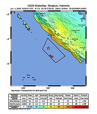
At 23:28 local time on June 4, 2000 southern Sumatra, Indonesia was struck by an earthquake of moment magnitude 7.9 with a maximum Mercalli intensity of VI (Strong). The event occurred off the coast near Enggano Island. There were more than 100 fatalities and up to 2,585 injuries. Over 730 aftershocks shook the area afterwards, one just eleven minutes after the mainshock.

<span class="mw-page-title-main">Sunda megathrust</span> Geological feature

The Sunda megathrust is a fault that extends approximately 5,500 km (3300 mi) from Myanmar (Burma) in the north, running along the southwestern side of Sumatra, to the south of Java and Bali before terminating near Australia. It is a megathrust, located at a convergent plate boundary where it forms the interface between the overriding Eurasian plate and the subducting Indo-Australian plate. It is one of the most seismogenic structures on Earth, being responsible for many great and giant earthquakes, including the 2004 Indian Ocean earthquake and tsunami that killed over 227,000 people. The Sunda megathrust can be divided into the Andaman Megathrust, Sumatra(n) Megathrust and Java(n) Megathrust. The Bali-Sumbawa segment is much less active and therefore does not have the "megathrust" term associated with it.

<span class="mw-page-title-main">April 2010 Sumatra earthquake</span> Earthquake in Indonesia

The April 2010 Sumatra earthquake occurred on April 7 at 5:15 AM local time with a moment magnitude of 7.8 and a maximum Mercalli intensity of V (Moderate). The shock occurred near the Banyak Islands, off the island of Sumatra in Indonesia. A tsunami watch was issued according to the Pacific Tsunami Warning Center in Honolulu which was later canceled. A 40 cm surge was reported in the Banyak Islands an hour after the quake, along with 62 injuries. Power outages were reported throughout the province of North Sumatra as well as in Aceh. This quake is one in a sequence of large earthquakes along the Sunda megathrust in the 2000s.

<span class="mw-page-title-main">2010 Mentawai earthquake and tsunami</span> 2010 Indonesian earthquake and tsunami

The 2010 Mentawai earthquake occurred with a moment magnitude of 7.8 on 25 October off the western coast of Sumatra at 21:42 local time. The earthquake occurred on the same fault that produced the 2004 Indian Ocean earthquake. It was widely felt across the provinces of Bengkulu and West Sumatra and resulted in a substantial localized tsunami that struck the Mentawai Islands.

<span class="mw-page-title-main">Tsunami earthquake</span> Type of earthquake which triggers a tsunami of far-larger magnitude

In seismology, a tsunami earthquake is an earthquake which triggers a tsunami of significantly greater magnitude, as measured by shorter-period seismic waves. The term was introduced by Japanese seismologist Hiroo Kanamori in 1972. Such events are a result of relatively slow rupture velocities. They are particularly dangerous as a large tsunami may arrive at a coastline with little or no warning.

The 2012 Indian Ocean earthquakes were magnitude 8.6 and 8.2 Mw  undersea earthquakes that struck near the Indonesian province of Aceh on 11 April at 15:38 local time. Initially, authorities feared that the initial earthquake would cause a tsunami and warnings were issued across the Indian Ocean; however, these warnings were subsequently cancelled. These were unusually strong intraplate earthquakes and the largest strike-slip earthquake ever recorded.

The 1999 Ambrym earthquake occurred on November 26 at 00:21:17 local time with a moment magnitude of 7.4 and a maximum Mercalli intensity of VII. The back arc thrust event occurred within the Vanuatu archipelago, just to the south of the volcanic island of Ambrym. Vanuatu, which was previously known as New Hebrides, is subject to volcanic and earthquake activity because it lies on an active and destructive plate boundary called the New Hebrides Subduction Zone. While the National Geophysical Data Center classified the total damage as moderate, a destructive local tsunami did result in some deaths, with at least five killed and up to 100 injured.

On January 1, 1996, at 4:05 p.m. Central Indonesia Time, an earthquake with an epicenter in the Makassar Strait struck north of Minahasa on the island of Sulawesi, Indonesia. The earthquake measured 7.9 on the moment magnitude scale and was centered off Tolitoli Regency in Central Sulawesi, or 25 km from the Tonggolobibi village. A tsunami of 2–4 m (6.6–13.1 ft) was triggered by this earthquake as a result. At least 350 buildings were badly damaged, nine people died and 63 people were injured.

The Nemuro-Oki earthquake in scientific literature, occurred on June 17 at 12:55 local time. It struck with an epicenter just off the Nemuro Peninsula in northern Hokkaidō, Japan. It measured 7.8–7.9 on the moment magnitude scale (Mw ), 8.1 on the tsunami magnitude scale (Mt ) and 7.4 on the Japan Meteorological Agency magnitude scale (MJMA ).

The 1852 Banda Sea earthquake struck on 26 November at 07:40 local time, affecting coastal communities on the Banda Islands. It caused violent shaking lasting five minutes, and was assigned XI on the Modified Mercalli intensity scale in the Maluku Islands. A tsunami measuring up to 8 m (26 ft) slammed into the islands of Banda Neira, Saparua, Haruku and Ceram. The tsunami caused major damage, washing away many villages, ships and residents. At least 60 people were killed in the earthquake and tsunami. The earthquake had an estimated moment magnitude of 7.5 or 8.4–8.8, according to various academic studies.

On the morning of January 5, 1699, a violent earthquake rocked the then Dutch East Indies city of Batavia on the island of Java, now known as the Indonesian capital city of Jakarta. Dutch accounts of the event described the earthquake as being "so heavy and strong" and beyond comparable to other known earthquakes. This event was so large that it was felt throughout west Java, and southern Sumatra.

<span class="mw-page-title-main">2021 Chignik earthquake</span> 7th largest earthquake in the US

An earthquake occurred off the coast of the Alaska Peninsula on July 28, 2021, at 10:15 p.m. local time. The large megathrust earthquake had a moment magnitude of 8.2 according to the United States Geological Survey (USGS). A tsunami warning was issued by the National Oceanic and Atmospheric Administration (NOAA) but later cancelled. The mainshock was followed by a number of aftershocks, including three that were of magnitude 5.9, 6.1 and 6.9 respectively.

The 1843 Nias earthquake off the northern coast of Sumatra, Indonesia caused severe damage when it triggered a tsunami along the coastline. The earthquake with a moment magnitude (Mw ) of 7.8 lasted nine minutes, collapsing many homes in Sumatra and Nias. It was assigned a maximum modified Mercalli intensity of XI (Extreme).

An earthquake affected the island of Java, Indonesia on 22 January 1780. The source and magnitude of the earthquake remains debated among seismologists. Proposed origins of the earthquake include shallow inland back-arc thrusting along a fault located within the upper crust on the island or rupture of the subduction zone off the southern coast of Java. The magnitude of the earthquake is estimated to be at least 8.5, while other sources usually refer to it with a range of Mw  8.0 to 8.5 for the megathrust earthquake. For the shallow crustal earthquake source, the magnitude range is Mw  7.0 to 8.0.

References

  1. 1 2 3 Ammon, C. J.; Kanamori, H.; Lay, T.; Velasco, A. A. (2006), "The 17 July 2006 Java tsunami earthquake" (PDF), Geophysical Research Letters, 33 (24): 1, Bibcode:2006GeoRL..3324308A, doi: 10.1029/2006gl028005
  2. 1 2 3 ISC (2016), ISC-GEM Global Instrumental Earthquake Catalogue (1900–2009), Version 3.0, International Seismological Centre
  3. Mori et al. 2010, p. 202
  4. 1 2 3 4 Kuenza, K.; Soon-Hoe, C. (2010), "Anatomy of the 17 July 2006 Java Earthquake Reveals Its Tsunamigenic Nature", Seismological Research Letters, 81 (1): 99–101, Bibcode:2010SeiRL..81...99K, doi:10.1785/gssrl.81.1.99
  5. Muhari, A.; Diposaptono, S.; Imamura, F. (2007), "Toward an integrated tsunami disaster mitigation: Lessons learned from previous tsunami events in Indonesia" (PDF), Journal of Natural Disaster Science, 29 (1): 15, doi: 10.2328/jnds.29.13
  6. 1 2 Mori et al. 2010 , p. 203
  7. 1 2 Yulianto, E.; Setja Atmadja, C. M. (2009), "Predecessors of the 2006 South Java Tsunami", Estimating the recurrence interval and behavior of tsunamis in the Indian Ocean via a survey of tsunami-related sedimentation, Tsukuba International Congress Center: National Research Institute for Earth Science and Disaster Prevention, p. 19
  8. 1 2 Reese, S.; Cousins, W. J.; Power, W. L.; Palmer, N. G.; Tejakusuma, I. G.; Nugrahadi, S. (2007), "Tsunami vulnerability of buildings and people in South Java – field observations after the July 2006 Java tsunami" (PDF), Natural Hazards and Earth System Sciences, 7 (5): 573, 580–582, Bibcode:2007NHESS...7..573R, doi: 10.5194/nhess-7-573-2007
  9. 1 2 Yeats, R. (2012), Active Faults of the World, Cambridge University Press, pp. 457, 462–464, ISBN   978-0-521-19085-5
  10. Irsyam, M.; Dangkua, D. T.; Hendriyawan; Hoedajanto, D.; Hutapea, B. M; Kertapati, E. K.; Boen, T.; Petersen, M. D. (2008), "Proposed seismic hazard maps of Sumatra and Java islands and microzonation study of Jakarta city, Indonesia" (PDF), Journal of Earth System Science, 117 (2): 868, 869, Bibcode:2008JESS..117..865I, doi:10.1007/s12040-008-0073-3, S2CID   129933598
  11. Okal, E. A. (2012), "The south of Java earthquake of 1921 September 11: a negative search for a large interplate thrust event at the Java Trench" (PDF), Geophysical Journal International, 190 (3): 1657–1659, Bibcode:2012GeoJI.190.1657O, doi: 10.1111/j.1365-246x.2012.05570.x
  12. 1 2 Mori et al. 2010 , p. 204
  13. 1 2 3 Fritz, H. M.; Kongo, W.; Moore, A.; McAdoo, B.; Goff, J.; Harbitz, C.; Uslu, B.; Kalligeris, N.; Suteja, D.; Kalsum, K.; Titov, V.; Gusman, A.; Latief, H.; Santoso, E.; Sujoko, S.; Djulkarnaen, D.; Sunendar, H.; Synolakis, C. (2007), "Extreme runup from the 17 July 2006 tsunami", Geophysical Research Letters, 34 (12): L12602, Bibcode:2007GeoRL..3412602F, doi: 10.1029/2007gl029404 , S2CID   129647228
  14. Georgia Institute of Technology (June 18, 2007). "Scientists report study results from 'stealth' tsunami that killed 600 in Java last summer" (Press release). Eurekalert!.
  15. 1 2 Bliss, D.; Campbell, J. (2007), The immediate response to the Java tsunami: Perceptions of the affected (PDF), Fritz Institute, pp. 2–6, archived from the original (PDF) on 2019-11-05

Sources

Further reading