
The 1872 Owens Valley earthquake – also known as the Lone Pine earthquake – struck on March 26 at in the Owens Valley, with the epicenter near the town of Lone Pine. Its magnitude has been estimated at 7.4 to 7.9, with a maximum Mercalli Intensity of X (Extreme). It was one of the largest earthquakes to hit California in recorded history and was similar in size to the 1906 San Francisco earthquake. Twenty-seven people were killed and fifty-six were injured.

The 2004 Al Hoceima earthquake occurred on 24 February at 02:27:47 local time near the coast of northern Morocco. The strike-slip earthquake measured 6.3 on the moment magnitude scale and had a maximum perceived intensity of IX (Violent) on the Mercalli intensity scale. Between 628 and 631 people were killed, 926 were injured, and up to 15,000 people were made homeless in the Al Hoceima-Imzourene-Beni Abdallah area.

The 2002 Denali earthquake occurred at 22:12:41 UTC November 3 with an epicenter 66 km ESE of Denali National Park, Alaska, United States. This 7.9 Mw earthquake was the largest recorded in the United States in 37 years. The shock was the strongest ever recorded in the interior of Alaska. Due to the remote location, there were no fatalities and only one injury.

In the early morning hours of August 16, 1931, a powerful earthquake occurred in West Texas with a maximum Mercalli intensity of VIII (Severe). Estimates of its magnitude range between 5.8–6.4 mb, making it the most powerful earthquake ever recorded in Texas history. Its epicenter was near the town of Valentine, Texas; there, the earthquake caused damage to many homes and buildings. The earthquake may have been caused by movement along oblique-slip faulting in West Texas, the most seismically-active region in the state. Shaking from the earthquake was perceptible within a 400 mi (640 km) radius of the epicenter, affecting four U.S. states and northern Mexico. Several foreshocks and aftershocks accompanied the primary temblor, with the aftershocks continuing until at least November 3, 1931. The main earthquake caused no fatalities, though several people sustained minor injuries; the damage in Valentine amounted to $50,000–$75,000.
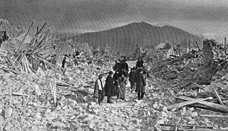
The 1915 Avezzano earthquake or 1915 Fucino earthquake occurred on 13 January in central Italy at . The shock had a moment magnitude of 6.7 and a maximum Mercalli intensity of XI (Extreme). The epicenter was located in the city of Avezzano in the Province of L'Aquila. Around 30,000 direct fatalities and $60 million in damage resulted from the earthquake.
The 1986 Chalfant Valley earthquake struck southern Mono County near Bishop and Chalfant, California at Pacific Daylight Time on July 21. With a moment magnitude of 6.2 and a maximum Mercalli intensity of VI (Strong), the shock injured two people and caused property damage estimated at $2.7 million in the affected areas. There was a significant foreshock and aftershock sequence that included a few moderate events, and was the last in a series of three earthquakes that affected southern California and the northern Owens Valley in July 1986.

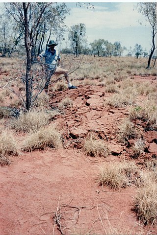
The Sagaing Fault is a major fault in Myanmar, a mainly continental right-lateral transform fault between the Indian Plate and Sunda Plate. It links the divergent boundary in the Andaman Sea with the zone of active continental collision along the Himalayan front. It passes through populated cities of Mandalay, Yamethin, Pyinmana, the capital Naypyidaw, Toungoo and Pegu before dropping off into the Gulf of Martaban, running for a total length of over 1200 kilometers.
The 1979 Imperial Valley earthquake occurred at 16:16 Pacific Daylight Time on 15 October just south of the Mexico–United States border. It affected Imperial Valley in Southern California and Mexicali Valley in northern Baja California. The earthquake had a relatively shallow hypocenter and caused property damage in the United States estimated at US$30 million. The irrigation systems in the Imperial Valley were badly affected, but no deaths occurred. It was the largest earthquake to occur in the contiguous United States since the 1971 San Fernando earthquake eight years earlier.
The 1838 San Andreas earthquake is believed to be a rupture along the northern part of the San Andreas Fault in June 1838. It affected approximately 100 km of the fault, from the San Francisco Peninsula to the Santa Cruz Mountains. It was a strong earthquake, with an estimated moment magnitude of 6.8 to 7.2, making it one of the largest known earthquakes in California. The region was lightly populated at the time, although structural damage was reported in San Francisco, Oakland, and Monterey. It is unknown whether there were fatalities. Based on geological sampling, the fault created approximately 1.5 meters of slip.
The 1930 Bago (Pegu) earthquake, also known as the Swa earthquake struck Myanmar on 5 May. The moment magnitude (Mw ) 7.4 earthquake had a focal depth of 35 km (22 mi) and maximum Rossi–Forel intensity of IX. The earthquake was the result of rupture along a 131 km (81 mi) segment of the Sagaing Fault—a major strike-slip fault that runs through the country. Extensive damage was reported in the southern part of the country, particularly in Bago and Yangon, where buildings collapsed and fires erupted. At least 550, and possibly up to 7,000 people were killed. A moderate tsunami was generated along the Burmese coast which caused minor damage to ships and a port. It was felt for over 570,000 km2 (220,000 sq mi) and as far as Shan State and Thailand. The mainshock was followed by many aftershocks; several were damaging; additional earthquakes occurred in July and December, killing dozens. The December earthquake was similarly sized which also occurred along the Sagaing Fault.
The 1988 Lancang–Gengma earthquakes, also known as the 11.6 earthquakes by the Chinese media were a pair of devastating seismic events that struck Lancang and Gengma counties, Yunnan, near the border with Shan State, Burma. The earthquake measured moment magnitude (Mw ) 7.0 and was followed 13 minutes later by a 6.9 Mw shock. These earthquakes were assigned a maximum China seismic intensity of IX and X, respectively. Between 748 and 939 people were killed; more than 7,700 were injured. Both earthquakes resulted in US$270 million in damage and economic losses. Moderately large aftershocks continued to rock the region, causing additional casualties and damage.
In 1954, the state of Nevada was struck by a series of earthquakes that began with three magnitude 6.0+ events in July and August that preceded the Mw 7.1–7.3 mainshock and M 6.9 aftershock, both on December 12. All five earthquakes are among the largest in the state, and the largest since the Cedar Mountain earthquake of 1932 and Pleasant Valley event in 1915. The earthquake was felt throughout much of the western United States.
The Cedar Mountain earthquake of 1932 was one of the largest seismic events in the US state of Nevada. The 7.3 earthquake struck at Cedar Mountain in Western Nevada. Shaking was felt as far as Oregon, Southern California, and the Rocky Mountains area. Nevada is the third most seismically active state in the United States due to ongoing rifting occurring within the North American Plate. Extension or thinning of the crust has resulted in numerous faults accommodating strain, at the same time, producing earthquakes. Since the earthquake occurred in a remote part of the state, damage was limited and no deaths were reported.
The 1968 Borrego Mountain earthquake occurred on April 8, at 18:28 PST in the geologically active Salton Trough of Southern California. The Salton Trough represents a pull-apart basin formed by movements along major faults. This region is dominated by major strike-slip faults one of them being the San Jacinto Fault which produced the 1968 earthquake. The mainshock's epicenter was near the unincorporated community of Ocotillo Wells in San Diego County. The moment magnitude (Mw ) 6.6 strike-slip earthquake struck with a focal depth of 11.1 km (6.9 mi). The zone of surface rupture was assigned a maximum Modified Mercalli intensity (MMI) of VII.
The 1979 Ghaenat earthquakes were a series of large earthquakes in Qaen County, Khorasan Province, northeast Iran, near the Afghanistan border. The first mainshock, known as the Korizan earthquake with a surface wave magnitude (Ms ) of 6.6 and moment magnitude (Mw ) of 6.8, struck on November 14, while the Ms 7.1 or Mw 7.2 Koli-Boniabad earthquake struck on November 27. The two mainshocks were assigned a maximum Modified Mercalli intensity of VIII (Severe) and X (Extreme), respectively. The earthquakes caused extensive damage throughout northeastern Iran, killing an estimated 297 to 440 people and left at least 279 injured.
The 1997 Bojnurd earthquake occurred on 4 February at 14:07 IRST in Iran. The epicenter of the 6.5 earthquake was in the Kopet Dag mountains of North Khorasan, near the Iran–Turkmenistan border, about 579 km (360 mi) northeast of Tehran. The earthquake is characterized by shallow strike-slip faulting in a zone of active faults. Seismic activity is present as the Kopet Dag is actively accommodating tectonics through faulting. The earthquake left 88 dead, 1,948 injured, and affected 173 villages, including four which were destroyed. Damage also occurred in Shirvan and Bojnord counties. The total cost of damage was estimated to be over US$ 30 million.
On 22 January 1988, a sequence of destructive earthquakes measuring 6.2, 6.3, and 6.6 struck southwest of Tennant Creek, Australia which was felt as far north as Darwin and in other regions of the country. The largest event of the sequence was the largest earthquake ever recorded in mainland Australia since records began in 1800. An intensity of IX (Violent) was observed. Despite the large magnitude of the earthquakes and a close proximity to a town, in a country where earthquakes of this size are not common, damages were limited. Thousands of aftershocks were reported and felt across Northern Territory.
The 1977 Naghan earthquake struck Chaharmahal and Bakhtiari province in Iran on April 6 at 13:36 UTC. The earthquake measuring 6.0 Mw occurred at a depth of 15 km (9.3 mi) and had a maximum Modified Mercalli intensity of VIII (Severe). More than 2,100 homes were destroyed and at least 348 people were killed.
The 1912 Acambay earthquake struck the State of Mexico on 19 November at 07:55 local time. It had a moment magnitude of 6.7–6.9 Mw and an epicenter near the town of Acambay, 80 km (50 mi) northwest of Mexico City. Up to 161 people died and there was severe destruction. It is regarded as one of the most important earthquakes in Mexico's seismological history, having been widely studied.
The 1983 Kaoiki earthquake struck southern Hawaii Island on the morning of November 16, 1983. Measuring Mw 6.7, it was the largest to hit the island since 1975. The epicenter was located 50 km southeast of Hilo with an approximated depth of 12 km. The shallow strike-slip earthquake was assigned a maximum intensity of IX (Violent) on the Modified Mercalli scale. 6 people were injured, widespread damage and landslides were reported across the island.

