
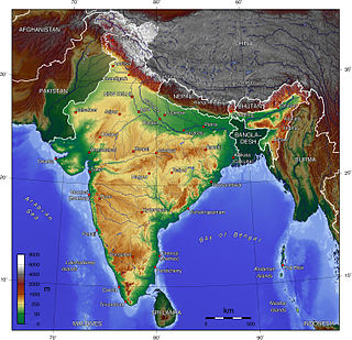
The Himalayas, or Himalaya, is a mountain range in Asia, separating the plains of the Indian subcontinent from the Tibetan Plateau. The range has some of the Earth's highest peaks, including the highest, Mount Everest; more than 100 peaks exceeding elevations of 7,200 m (23,600 ft) above sea level lie in the Himalayas.

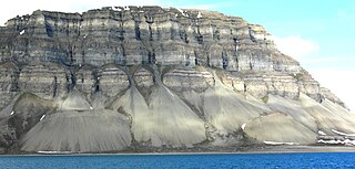
Scree is a collection of broken rock fragments at the base of a cliff or other steep rocky mass that has accumulated through periodic rockfall. Landforms associated with these materials are often called talus deposits. Talus deposits typically have a concave upwards form, where the maximum inclination corresponds to the angle of repose of the mean debris particle size. The exact definition of scree in the primary literature is somewhat relaxed, and it often overlaps with both talus and colluvium.
Mass wasting, also known as mass movement, is a general term for the movement of rock or soil down slopes under the force of gravity. It differs from other processes of erosion in that the debris transported by mass wasting is not entrained in a moving medium, such as water, wind, or ice. Types of mass wasting include creep, solifluction, rockfalls, debris flows, and landslides, each with its own characteristic features, and taking place over timescales from seconds to hundreds of years. Mass wasting occurs on both terrestrial and submarine slopes, and has been observed on Earth, Mars, Venus, Jupiter's moon Io, and on many other bodies in the Solar System.
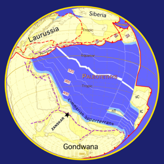
The geology of the Himalayas is a record of the most dramatic and visible creations of the immense mountain range formed by plate tectonic forces and sculpted by weathering and erosion. The Himalayas, which stretch over 2400 km between the Namcha Barwa syntaxis at the eastern end of the mountain range and the Nanga Parbat syntaxis at the western end, are the result of an ongoing orogeny — the collision of the continental crust of two tectonic plates, namely, the Indian Plate thrusting into the Eurasian Plate. The Himalaya-Tibet region supplies fresh water for more than one-fifth of the world population, and accounts for a quarter of the global sedimentary budget. Topographically, the belt has many superlatives: the highest rate of uplift, the highest relief, among the highest erosion rates at 2–12 mm/yr, the source of some of the greatest rivers and the highest concentration of glaciers outside of the polar regions. This last feature earned the Himalaya its name, originating from the Sanskrit for "the abode of the snow".

A rockfall or rock-fall is a quantity/sheets of rock that has fallen freely from a cliff face. The term is also used for collapse of rock from roof or walls of mine or quarry workings. "A rockfall is a fragment of rock detached by sliding, toppling, or falling, that falls along a vertical or sub-vertical cliff, proceeds down slope by bouncing and flying along ballistic trajectories or by rolling on talus or debris slopes."

Darashaw Nosherwan Wadia FRS was a pioneering geologist in India and among the first Indian scientists to work in the Geological Survey of India. He is remembered for his work on the stratigraphy of the Himalayas. He helped establish geological studies and investigations in India, specifically at the Institute of Himalayan Geology, which was renamed in 1976 after him as the Wadia Institute of Himalayan Geology. His textbook on the Geology of India, first published in 1919, continues to be in use.
John Bicknell Auden was an English geologist and explorer, older brother of the poet W. H. Auden, who worked for many years in India with the Geological Survey of India and later with the Food and Agriculture Organization. He studied the Himalayan strata, particularly the Krol Belt where he recognized rocks from the Peninsula thrusting north into the Himalayas. He also studied groundwater and was involved in studying the geology of many dam sites in India. Auden's Col is named after him.
The Indian Himalayan Region is the section of the Himalayas within the Republic of India, spanning thirteen Indian states and union territories, namely Ladakh, Jammu and Kashmir, Himachal Pradesh, Uttarakhand, Sikkim, West Bengal, Manipur, Meghalaya, Mizoram, Nagaland, Tripura, Assam, and Arunachal Pradesh. The region is responsible for providing water to a large part of the Indian subcontinent and contains various flora and fauna.
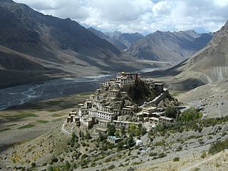
The 1975 Kinnaur earthquake occurred in the early afternoon of 19 January. It had a magnitude of 6.8 on the surface wave magnitude scale and a maximum perceived intensity of IX (Violent) on the Mercalli intensity scale, causing extensive damage in Himachal Pradesh, in northern India. Its epicentre was in Kinnaur district in the southeastern part of Himachal Pradesh and caused 47 casualties. Landslides, rock falls and avalanches caused major damage to the Hindustan-Tibet Road. The earthquake affected many monasteries and buildings in the state and led to an extensive restoration work in the late 1970s and early 1980s in Himachal Pradesh. The Spiti and Parachu valleys in particular suffered the greatest damage being on the north–south Kaurik-Chango fault, causing damage to landmarks such as Key Monastery and Tabo Monastery.

Wadia Institute of Himalayan Geology, Dehradun is an autonomous Natural Resources research institute for the study of Geology of the Himalaya under the Department of Science and Technology, Ministry of Science and Technology, Government of India. It was established in June, 1968 in the Botany Department, Delhi University, the Institute was shifted to Dehradun, Uttarakhand during April, 1976.

The Himalayan foreland basin is an active collisional foreland basin system in South Asia. Uplift and loading of the Eurasian Plate on to the Indian Plate resulted in the flexure (bending) of the Indian Plate, and the creation of a depression adjacent to the Himalayan mountain belt. This depression was filled with sediment eroded from the Himalaya, that lithified and produced a sedimentary basin ~3 to >7 km deep. The foreland basin spans approximately 2,000 kilometres (1,200 mi) in length and 450 kilometres (280 mi) in width. From west to east the foreland basin stretches across five countries: Pakistan, India, Nepal, Bangladesh, and Bhutan.
Khadg Singh Valdiya was an Indian geologist and a former vice chancellor of Kumaon University, internationally recognized for his path-breaking work in the fields of geodynamics and Environmental Science. A 2007 recipient of Padma Shri, he was honoured again by the Government of India in 2015 with Padma Bhushan, the third highest Indian civilian award.

The Sarju, also known as Sarayu, is a major river draining Central Kumaon region in the Indian state of Uttarakhand. Originating from Sarmul, Sarju flows through the cities of Kapkot, Bageshwar and Seraghat before joining Mahakali at Pancheshwar. The Sarju is the largest tributary of the Sharda River. The river forms the South-eastern border between the districts of Pithoragarh and Almora. Temperate and sub-Tropical forests cover the entire Catchment area of the River.

The 2010 Mount Meager landslide was a large catastrophic debris avalanche that occurred in southwestern British Columbia, Canada, on August 6 at 3:27 a.m. PDT (UTC-7). More than 45,000,000 m3 (1.6×10⁹ cu ft) of debris slid down Mount Meager, temporarily blocking Meager Creek and destroying local bridges, roads and equipment. It was one of the largest landslides in Canadian history and one of over 20 landslides to have occurred from the Mount Meager massif in the last 10,000 years.

The 2021 Uttarakhand flood, also known as the Chamoli disaster, began on 7 February 2021 in the environs of the Nanda Devi National Park, a UNESCO World Heritage Site in the outer Garhwal Himalayas in Uttarakhand state, India. It was caused by a large rock and ice avalanche consisting of material dislodged from Ronti peak. It caused flooding in the Chamoli district, most notably in the Rishiganga river, the Dhauliganga river, and in turn the Alaknanda—the major headstream of the Ganges. The disaster left over 200 killed or missing. Most were workers at the Tapovan dam site.
The 1555 Kashmir earthquake occurred at around midnight in the month of Ashvin in the Hindu calendar, or September in the Gregorian calendar, although the exact day of occurrence is not known. The earthquake seriously impacted the Kashmir Valley in present-day Pakistan and northwestern India. A moment magnitude (Mw ) of 7.6 to 8.0 and Modified Mercalli intensity of XII (Extreme) has been estimated for the earthquake. Thought to be one of the most destructive in the Kashmir Valley, the earthquake caused serious widespread damage and ground effects, killing an estimated 600–60,000 individuals.
The 1885 Kashmir earthquake, also known as the Baramulla earthquake occurred on 30 May in Srinagar. It had an estimated moment magnitude of Mw 6.3–6.8 and maximum Medvedev–Sponheuer–Karnik scale intensity of VIII (Damaging). At least 3,081 people died and severe damage resulted.
The 1803 Garhwal earthquake occurred in the early morning of September 1 at 01:30 local time. The estimated 7.8-magnitude-earthquake had an epicenter in the Garhwal Himalaya near Uttarkashi, British India. Major damage occurred in the Himalaya and Indo-Gangetic Plain, with the loss of between 200 and 300 lives. It is among the largest Himalaya earthquakes of the 19th-century, caused by thrust faulting.
The Tsergo Ri landslide was a prehistoric landslide in the Nepalese Himalaya, which took place around 51,000±13,000 years ago, during the Last Glacial Period. During the collapse, a mass of rock of about 10–15 cubic kilometres (2.4–3.6 cu mi) detached from a previous mountain or ridge and descended with a speed of about 450 kilometres per hour (120 m/s); later, glaciers eroded almost the entire landslide mass. Previously weakened rocks may have contributed to the collapse, which was probably started by an earthquake.
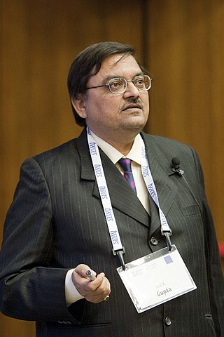
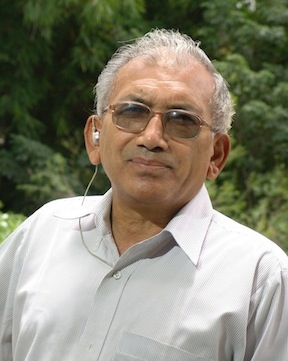
Anil Kumar Gupta is a scientist and researcher from India who served as a professor in the Department of Geology and Geophysics at the Indian Institute of Technology Kharagpur. He was also the former director (2010–2017) of the Wadia Institute of Himalayan Geology, Dehradun, India. His teaching interests include applied micropaleontology, paleoceanography and marine geosciences.
