List of landslides

Last updated
Frank Slide, Turtle Mountain, Alberta, Canada Frank Slide, Canada.jpg
Frank Slide, Turtle Mountain, Alberta, Canada

This list of landslides is a list of notable landslides and mudflows divided into sections by date and type. This list is very incomplete as there is no central catalogue for landslides, although some for individual countries/areas do exist. Volumes of landslides are recorded in the scientific literature using cubic kilometres (km3) for the largest and millions of cubic metres (normally given the non-standard shortening of MCM) for most events.

Contents

Prehistoric landslides

Note: km3 = cubic kilometre(s)

DatePlaceNameLat.Long.VolumeCommentsSources
48 Ma Heart Mountain, Wyoming, US Heart Mountain slide~2000 km3Mostly eroded now [1] [2]
21–22 MaSouthwest Utah, US Markagunt gravity slide37.7N112.83W~1700–2000 km3 [3] [1]
~6.1 MaEast Traverse Mountains, Utah, USEast Traverse Mountains mega landslide40.48N111.85W~50–100 km3The landslide comprises the entirety of East Traverse Mountain [4] [5]
ca. 71,000 BCE Fogo, Cape Verde Islands 15.00N024.45W130–160 km3The eastern flank of the island of Fogo collapsed into the sea, generating a megatsunami. The wave struck Santiago, 55 kilometres (34 mi; 30 nmi) away, with a height of at least 170 metres (558 ft). [6] [7]
Sometime between 19,000 and 10,000 BCE Lake Tahoe, California and Nevada, United States12.5 km3The landslide occurred along the western shore of the lake, forming McKinney Bay and generating megatsunamis in the lake of about 100 metres (328 ft) in height. [8] [9]
ca. 15,000 BCE San Bernardino Mountains, California, United StatesBlackhawk slide0.52 km3A cube of rock 0.5 miles (0.8 km) on a side slid 1,500 feet (457 m) down the slope of a steep canyon, then exited the canyon and traveled for 5 miles (8 km) across a flat valley at a speed of up to 75 miles per hour (121 km/h). [10]
13,500 BCE Green Lake (Southland) New ZealandGreen Lake landslide45.78S167.37E27 km3Likely triggered by large earthquake on or near the Alpine Fault [11]
Late Pleistocene British Columbia Cheekye Fan ~0.15 km3Collapse of the western flank of Mount Garibaldi [12]
≈ 10,000 BCE Seymareh, Iran Seymareh landslide 33N47.65E20 km3Collapse of the north-eastern flank of Kabir Kouh ridge across the Seymareh River [13]
~9900 BCE Otago, New Zealand Lochnagar Landslide 44.36S168E1 km3Collapse of mountain forming Lake Lochnagar. [14]
Between ~8020 and ~6520 BCE Sullorsuaq Strait, Greenland VariousSeven very large tsunamigenic landslides struck Sullorsuaq Strait over this 1,500-year period, some from the southern coast of the Nuussuaq Peninsula and others from the northern coast of Disko Island. No evidence has been found of the tsunamis or megatsunamis they probably generated. [15]
~6370 BCE Mount Etna, Sicily 25 km3An 80-square-kilometre (31 sq mi), 300-metre (984 ft) thick area of the eastern slope of Mount Etna collapsed into the Mediterranean Sea, triggering a megatsunami in the Eastern Mediterranean with an initial wave height along the coast of Sicily of 40 metres (131 ft). It struck the Neolithic village of Atlit Yam off what is now the coast of Israel, where it had a height of 2.5 metres (8 ft 2 in) and prompted the village's abandonment. [16] [17] [18] [19] [20]
~5650 BCE Sullorsuaq Strait, Greenland A large landslide entered Sullorsuaq Strait, generating a megatsunami which struck Alluttoq Island, where it had a run-up height of 41 to 66 metres (135 to 217 ft). [15]
~5350 BCE Sullorsuaq Strait, Greenland A large landslide entered Sullorsuaq Strait, generating a megatsunami which struck Alluttoq Island, where it had a run-up height of 45 to 70 metres (148 to 230 ft). [15]
~2800 BCE Zion Canyon, Utah, US 0.286 km3Landslide created the currently level floor of Zion Canyon inside Zion National Park. [21]
~1920 BCEJishi Gorge, Qinghai Province, China Jishi Gorge outburst flood 0.040–0.080 km3Landslide dammed the Yellow River, breach of dam may have caused the Great Flood of Gun-Yu [22]
≈ 200 BCE North Island, New Zealand 2.2 km3Dammed Lake Waikaremoana [23] [24]

Submarine landslides

Note: MCM = million cubic metres; km3 = cubic kilometre(s)

DatePlaceName/articleLat.Long.VolumeCommentsSources
1.4 Maoff northern Molokai, Hawaii Wailau Slide2,500 km3The northern third of East Molokai Volcano collapsed suddenly into the Pacific Ocean in a 25-mile (40 km) wide landslide with a 120-mile (193 km) run-out that climbed uphill 900 feet (274 m) from the Hawaiian Trough over the last 80 miles (130 km). It generated a tsunami that was 2,000 feet (610 m) tall locally and which reached California and Mexico. [25]
Between 1.5 and 0.5 Maoff northeastern Oahu, Hawaii Nu'uanu Slide 7,500 km3The eastern half of the Koʻolau Volcano collapsed into the Pacific Ocean, leaving behind its remnant western rim on Oahu as the Koʻolau Range The landslide had a run-out of more than 140 miles (225 km), climbing about 1,000 feet (305 m) over the last 85 miles (137 km) and leaving a massive debris field north of Oahu and Molokai covering 25,000 square kilometers (9,700 sq mi). The largest piece of debris, the Tuscaloosa Seamount, measures 19 by 11 miles (31 by 18 km) and rises 1.1 miles (1.8 km) above the seafloor. [26] [27]
Less than 2.6 Maoff South Africa Agulhas Slide20,000 km3The largest so far described [28] [29]
ca. 170,000 BP off North Island, New ZealandRuatoria debris avalanche3,000 km3 [30]
ca. 8,000 BP Norwegian Sea Storegga Slide 64.871.33,500 km3Triggered a large tsunami that swept over the Shetland and Orkney Islands [31]
18 Nov 1929 Grand Banks of Newfoundland 1929 Grand Banks earthquake 44.54−56.01200 km3Broke 12 submarine communications cables. The tsunami was 3 to 8 metres (10 to 26 ft) tall, had a run-up of 13 metres (43 ft), and killed 28 people on the Burin Peninsula. [32]
17 Jul 1998North of New Guinea 1998 Papua New Guinea earthquake 4 km3The landslide in the Pacific Ocean followed an M 7.0 earthquake by a few minutes and generated tsunamis with heights of 10 to 15 metres (33 to 49 ft) that struck the north coast of Papua New Guinea, killing 2,100 to 2,700 people, injuring 1,000, and leaving 10,000 homeless. [33]

Pre-20th-century historic landslides

Note: km3 = cubic kilometre(s); MCM = million cubic metres

DatePlaceName/articleLat.Long.VolumeCasualtiesCommentsSources
563 Lake Geneva, Switzerland and France Tauredunum event 46.356.86Hundreds to thousandsA landslide apparently triggered a collapse of sediments at the mouth of the River Rhône, resulting in a submarine mudslide that triggered a tsunami which traveled the length of Lake Geneva, reaching a height of 16 metres (52 ft) in some places. The wave destroyed villages and reached Geneva. [34] [35] [36] [37] [38] [39]
25 Nov 1248 Mont Granier, France45.465.931000+Destroyed five villages.
25 Jan 1348 Dobratsch, AustriaDobratsch Landslide900 MCMTriggered by the Friuli earthquake (8-9 EMS), due to the flood of the river Gail, 2 villages had to be abandoned.
1425 - 1450 North Bonneville, Washington, US Bridge of the Gods (land bridge) 45.66-121.9414 km3Possibly linked to the 1458 Cascadia Earthquake [40] [41] [42]
About 1560 Ozette, Washington, US Ozette Indian Village Archeological Site 48.17-124.73Partially buried the village at Ozette [43] [44]
1692 Judgment Hill, Jamaica 1692 Jamaica earthquake 131–181 MCM19 white people killed; other possible deaths not recordedThe landslide displaced the land surface by up to 800 metres (2,625 ft). The debris travelled 440 metres (1,444 ft) vertically and 1.763 kilometres (1.095 mi) horizontally and accumulated over a 1.09-square-kilometre (0.42 sq mi) area. Documentationm of the timing of the landslide is inexact, but it occurred after the 7 June 1692 earthquake at Port Royal and may have occurred due to heavy rainfall which followed the earthquake, and possibly due to rain associated with a hurricane that struck the area in October 1692. [45] [46]
19 June 1718 Gansu, China 1718 Tongwei–Gansu earthquake An Ms 7.5 earthquake triggers over 300 landslides, burying villages and resulting in 73,000 deaths. [47]
22 Feb 1756 Langfjorden, Norway 12 to 15 MCM32Slid 400 metres (1,312 ft) down the slope of the mountain Tjellafjellet into the Langfjorden, generating three megatsunamis in the Langfjorden and the Eresfjorden with heights of 40 to 50 metres (131 to 164 ft). The largest landslide in Norway in historic time. [48]
1 Jun 1786 Kangding-Luding area, Sichuan, southwestern China 1786 Kangding-Luding earthquake A M 7.75 earthquake triggered a large landslide that created a 70-metre (230 ft) high landslide dam in the Dadu River. The dam failed catastrophically on 10 June, the resulting flood extending 1,400 kilometres (870 mi) downstream and killing 100,000 people. [49] [50]
2 Sep 1806 Canton of Schwyz, Switzerland Goldau Rockslide47.058.5540 MCM 457Destroyed four villages and caused a tsunami in Lake Lauerz [51]
24 Dec 1839 Lyme Regis, Dorset Axmouth to Lyme Regis Undercliff One of a series of slumps
1855–1856 British Columbia Collapse of The Barrier 30 MCM [52]
1881 Qiaojia County, Yunnan, ChinaShigaodi Landslide530 MCMFormed dam on Jinsha River [53]
11 Sep 1881 Elm, Switzerland 7.6 MCM114–115A mountainside weakened by quarrying and two months of heavy rains slid into the village, where it buried 83 structures, then across the valley the village stood in and 300 yards (274 m) up the opposite slope. [10] [54]
13 Mar 1888 Ritter Island, Netherlands East Indies 1888 Ritter Island eruption and tsunami 4 to 5 km3ca. 3,000During a volcanic eruption, a significant portion of the island slid 800 metres (2,625 ft) into the sea, generating tsunamis of up to 12 to 15 metres (39 to 49 ft) in height that struck nearby islands and traveled as far south as New Guinea, where they were 8 metres (26 ft) high. [55] [56]
[57] [58] [59]
19 Sep 1889 Cap Diamant, Quebec Québec rockslide 46.485−71.21>40 [60]

20th-century landslides

1901–1950

Note: km3 = cubic kilometre(s); MCM = million cubic metres

DatePlaceName/articleLat.Long.VolumeCasualtiesCommentsSources
22 Aug 1902 China–Kyrgyzstan border, Xinjiang, China 1902 Turkestan earthquake 39.8776.42>0.2 MCM5,650–10,000A landslide triggered by an Mw 7.7 earthquake in the Tian Shan mountains. The earthquake triggered landslides in valleys and mountains. Destruction was widespread. [61] [62] [63]
29 Apr 1903 Turtle Mountain, Alberta, Canada Frank Slide 49.59−114.3930 MCM70 to 90
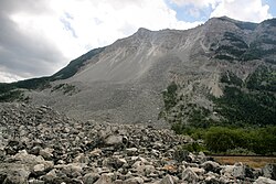
About 110 million tonnes (120 million short tons) of limestone rock slid down Turtle Mountain, reaching the opposing hills in 100 seconds and burying the eastern edge of Frank, a mining town then in Alberta. The deadliest and one of the largest landslides in Canadian history. [64] [65]
15 Jan 1905 Lovatnet, Norway 0.35 MCM61Slid 500 metres (1,640 ft) down the slope of the mountain Ramnefjellet into the lake Lovatnet, generating a megatsunami with a height of up to 40.5 metres (133 ft). [66]
13 Apr 1907Chryszczata, Bieszczady Mountains, Poland Zwiezło49.1822.1012 MCM0The biggest historical landslide in the Polish Bieszczady Mountains. Lakes formed in the depressions on the surface of the landslide - "Duszatyn Lakes". The lakes and the surrounding forest are protected in a nature reserve. [67]
18 Feb 1911 Usoy, Tajikistan Usoi Dam 2 km354Triggered by M 7.4 earthquake. The rockslide dammed the Murgab River, impounding 65 km (40 mi)-long Lake Sarez, which presently still exists. [68]
1914 Neuquén and Mendoza, Argentina Rio Barrancas & Rio Colorado debris flow2 MCM190–300Two small towns were devastated, and numerous ranches and farms destroyed along a 60 km (37 mi) valley. Length of flow:300 km (186 mi) [68]
19 May 1919 Kelud, East Java, Indonesia Kelut Lahars5110Lahars caused 5,110 deaths, and destroyed or damaged 104 villages. Length 185 km (115 mi). [68]
16 Dec 1920 Haiyuan County, Ningxia, China 1920 Haiyuan earthquake >100,000 Loess flows and landslides over an area of 50,000 km2 (19,000 sq mi). Failures in loess caused extreme fissuring, landslide dams, and buried villages. [68]
1920 Veracruz, Mexico Rio Huitzilapan debris flowsest. 600–870Debris flows destroyed village of Barranca Grande, and were 40 to 65 m (131 to 213 ft) deep. Debris flows extended >40 km (25 mi). Triggered by M~6.5 earthquake. [68]
1921 Almaty, Kazakhstan Alma-Ata Debris Flows~500A debris flow in the Valley of Alma-Atinka River destroyed the town of Alma-Ata. [68]
26 Mar 1924 Amalfi Coast, Italy ~100A series of major landslides after 18 hours of heavy rain [69]
23 Jun 1925 Gros Ventre Wilderness, Wyoming Gros Ventre landslide 43.62110.5538 MCM6 (when the dam failed in 1927)Blocked the Gros Ventre River, forming a 70-metre-high (230 ft) dam [70]
9 Mar 1929 Otehake River, Arthur's Pass National Park, South Island, New Zealand The Falling Mountain landslide−42.89171.6866 MCMVery rapid rock avalanche triggered by the 1929 Arthur's Pass earthquake [71]
25 Aug 1933 Diexi, Mao County, Sichuan, China 1933 Diexi earthquake 150 MCM~3100The largest landslide formed a 255-metre-high (837 ft) landslide dam on the Min River. This landslide killed all but one of the 577 people in the town of Deixi. The dam then overtopped, causing a flood and 2,500 deaths. [68]
7 Apr 1934 Tafjorden, Norway 2 to 3 MCM40Slid about 730 metres (2,395 ft) down the slope of the mountain Langhamaren into the Tafjorden, generating a megatsunami that reached a height of between 62 and 63.5 metres (203 and 208 ft). [72] [73] [74]
13 Sep 1936 Lovatnet, Norway 1 MCM74Slid 800 metres (2,625 ft) down the slope of the mountain Ramnefjellet into the lake Lovatnet, generating a megatsunami with a height of more than 74 metres (243 ft). [66]
5 Jul 1938 Kwansai, Hyogo Prefecture, Japan ~1000Many landslides occurred on the slopes of Mount Rokko, 130,000 homes damaged or destroyed by landslides and floods. [68] [75]
13 Dec 1941 Huaraz, Ancash, Peru Huaraz debris flow>10 MCM4,000–6,000Caused by rupture of a moraine dam impounding a lake, temporarily dammed the Santa River, after 2 days that failed and the flood swept down the valley to the coast. [68] [76]
16 Aug 1945 Mantaro Valley, Peru Kuntur Sinqa rockslide5.5 MCMnone from landslideThe rockslide formed a 100-metre-high (330 ft) dam at Rio Mantaro, which failed after 73 days, causing a flood. [68]
19 Dec 1945 Alcalá del Júcar, Albacete, Spain 16Worst rockfall to hit the municipality in the 20th century [77]
18 Sep 1948 Assam, India Guwahati landslide~500Triggered by heavy rain [78]
10 Jul 1949 Gharm Oblast, Tajikistan Khait landslide, Yasman valley flowslide39.1770.9075 MCM
245 MCM
~800
~4,000(7,200 for all the landslides)
Triggered by the 1949 Khait earthquake, largest of several landslides [79]

1951–1975

Note: km3 = cubic kilometre(s); MCM = million cubic metres

DatePlaceName/articleLat.Long.VolumeCasualtiesCommentsSources
15 Dec 1952 Nuussuaq Peninsula, western Greenland Niiortuut landslide70.349–53.1785.9 MCM1The landslide began at a height of 500 to 700 metres (1,640 to 2,297 ft) on a slope of the mountain Niiortuut, was 80 metres (262 ft) thick, and traveled 2,750 metres (3,007 yd). Between 1,800,000 and 4,500,000 cubic metres (2,400,000 and 5,900,000 cu yd) of material entered the sea and generated a tsunami in Sullorsuaq Strait (known in Danish as Vaigat Strait). With a run-up height of 4.5 to 7.7 metres (15 to 25 ft), it struck a group of four fishermen 10 kilometres (6.2 mi) away on the southern coast of the Nuussuaq Peninsula, killing one. Then it struck the town of Qullissat 30 kilometres (19 mi) away on Disko Island, where it had a run-up height of 2.2 to 2.7 metres (7 ft 3 in to 8 ft 10 in). [80] [81]
1953 Wakayama Prefecture, JapanArida River landslides1,046Multiple slides due to typhoon. Many landslide dams were formed and subsequently failed in the Arid-Kawa valley. [68]
1953 Minamiyamashiro, Sōraku District, Kyoto, JapanMinamiyamashiro landslides336 dead or missing5,122 homes were destroyed or badly damaged by landslides and floods. [68]
7 Oct 1953 Bekkelaget, Oslo, NorwayBekkelaget landslide 19535 dead [82]
12 Jul 1954Media Luna, Colombia Santa Elena landslide>100Mudflow triggered by heavy rain [83]
26 Oct 1954 Salerno, Amalfi Coast ≈ 300504 millimetres (19.8 in) of rain fell in 16 hours, causing soil slides & debris flows [84]
1958 Shizuoka Prefecture, Japan Kanogawa landslides1,09419,754 homes were destroyed or badly damaged. [68]
9 Jul 1958 Lituya Bay, Alaska, United States 1958 Lituya Bay, Alaska earthquake and megatsunami 30 MCM2Caused by M 7.5 earthquake, the landslide caused a megatsunami with a run-up of 524 metres (1,719 ft) in Lituya Bay. [85]
17 Aug 1959Madison Canyon, southwestern Montana, United States 1959 Hebgen Lake earthquake 38 MCM28–36Caused by M 7.2 to 7.5 earthquake. Dammed the Madison River, creating Quake Lake. [86]
22 May 1960 Riñihue Lake, Chile Riñihuazo −39.84−72.29≈ 40 MCMA series of landslides triggered by the 1960 Valdivia earthquake, blocked outflow of Riñihue Lake, causing it to rise more than 20 metres (66 ft), actions taken to lower the water level prevented repeat of a disastrous flood after the great 1575 earthquake. [76]
10 Jan 1962 Ranrahirca, Peru1962 Nevado Huascarán debris avalanche−9.12−77.613 MCM4,000 – 5,000An avalanche of ice and rock triggered by collapse of part of a hanging glacier [76]
9 Oct 1963 Longarone, ItalyVajont landslide46.2712.33270 MCM≈ 2,000Landslide caused by heavy rains and drawdown of the Vajont Dam reservoir. Casualties and damage caused by 250-metre (820 ft) tsunami generated by landslide into reservoir. [87]
27 Mar 1964 Seward, Alaska, United States 1964 Alaska earthquake 211 MCM at Seward, 9.6 MCM at Turnagain Heights106 from tsunami caused by Seward landslideM 9.2 earthquake caused submarine landslide at Seward, and large landslides in Anchorage. One large landslide traveled for 3 miles (4.8 km) across the nearly level surface of Sherman Glacier [10] [68]
9 Jan 1965 British Columbia Hope Slide 49.40-121.2648 MCM4"... no seismic or hydrometeorological trigger is discernible ..." [88]
28 Mar 1965El Cobre, Chile El Cobre landslide >200Shaking from a magnitude 7.1 earthquake caused failure of two tailings dams at the El Soldado copper mine, the resulting flow destroyed the town of El Cobre. [89]
1965 Luquan Yi and Miao Autonomous County, Yunnan, ChinaPufu Landslide450 MCMCreated a dam on the Pufuguo Stream, which later failed [53]
21 Oct 1966 Aberfan, Wales Aberfan disaster 51.693.35144Collapse of an unstable colliery spoil-tip built over a series of springs, was triggered by heavy rain, killing nearly half the children at the village school.
18 Feb 1967 Laranjeiras, Rio de Janeiro −22.97−43.20110Worst single event in a series of landslides caused by very heavy rain in the area around Rio de Janeiro in the summers of 1966 and 1967. A high-velocity debris avalanche struck three buildings, two of them apartment buildings. The preceding rainfall fell at up to 100 millimetres (3.9 in) per hour. [76]
18 Mar 1967 Caraguatatuba, Brazil −23.85−46.637.6 MCM120Followed heavy rain, 420 millimetres (17 in) in 24 hours. [90]
9 Jul 1967 Kure, Hiroshima Prefecture, Japan34.25132.57159Heavy rain from Typhoon Billie caused flooding and many landslides, destroying 352 buildings and damaging 551 roads [91]
18 Aug 1968 Hida River, Gero, Japan35.45137.05740 MCM (official estimate)104Triggered by a rainstorm, this debris flow swept two buses off the road, where they were stopped because of an earlier landslide [92]
3–5 Oct 1968 Darjeeling, India'thousands'Floods caused by rainfall of 500 to 1,000 millimetres (20 to 39 in), triggered many landslides, a 60-kilometre-long (37 mi) highway was cut in 92 places [93] [94]
19–20 Aug 1969 Nelson County, Virginia, United States150 (includes deaths from flooding)Remnants of Hurricane Camille dropped at least 710 millimetres (28 in) of rain in about 8 hours, triggering numerous debris flows [95]
31 May 1970 Yungay, Peru1970 Nevado Huascarán debris avalanche−9.12−77.650–100 MCM>22,000Triggered by the 1970 Ancash earthquake, the mass travelled 14.5 kilometres (9 mi) at an average velocity of about 300 km/h (186 mph) and buried Yungay [76] [96]
18 Mar 1971 Chungar, Peru Chungar avalanche and tsunami−11.12−76.530.1 MCM400–600A rock avalanche from a limestone outcrop fell into Yanawayin Lake causing a wave that devastated a mining camp [76] [97]
4 May 1971 Saint-Jean-Vianney, Quebec, CanadaSaint-Jean-Vianney landslide48.47−71.226.9 MCM31This slide occurred in quick clay following heavy rain, destroying 41 homes [98] [99]
18 Jun 1972 Hong Kong 1972 Hong Kong landslides 156A series of major landslides in which several apartment complexes and houses were wiped out [100]
6 Jul 1972 Amakusa, JapanAmakusa disaster115Multiple slope failures caused by heavy rainfall [101]
12–13 Jul 1972 Obara, Shikoku, JapanObara landslides64218 millimetres (8.6 in) of rain in 5 hours triggered many landslides [102] [103]
Apr 1974 Junín Region, Peru Mayunmarca Landslide1.0 to 1.6 km3450Rockslide dammed Río Mantaro. Slide velocity estimated at 120 to 140 km/h (75 to 87 mph). [104]
22 Jul 1975 Mount Meager massif, British Columbia, Canada Devastation Glacier landslide 0.013 km34Triggered by the collapse of a glacially debuttressed slope, descended Devastation Creek. [105] [106]

1976–2000

Note: MCM = million cubic metres

DatePlaceName/articleLat.Long.VolumeCasualtiesCommentsSources
30 Nov 1977Tuve, Gothenburg, Sweden Tuve landslide 57.7511.943–4 MCM9The most severe landslide in the modern history of Sweden, triggered by heavy rain [107]
29 Apr 1978 Rissa, Norway Rissa landslide 63.559.945–6 MCM1 Quick clay flowed suddenly into Botn lake, causing a small tsunami on the opposite shore [108]
8 Aug 1979 Abbotsford, Dunedin, South Island, New Zealand 1979 Abbotsford landslip −45.897170.4355 MCM0Heavy rain triggered a landslide on an unstable slope, made worse by sand quarrying at the base of the slope, destroying 69 houses [109]
18 May 1980 Mount St. Helens, Washington, United States 1980 eruption of Mount St. Helens 46.200278−122.1866672.9 km357The largest landslide in recorded history. Unplugged the volcanic vent, triggering the eruption. Deaths were from both the landslide and the eruption. Part of the landslide entered Spirit Lake, generating a megatsunami that reached a height of 260 metres (850 ft). [1]
1982 Santa Cruz Mountains, California, United States30A series of mud and debris flows occurred over a wide area. [110]
Apr 1983 Thistle, Utah, United States Thistle, Utah landslide 40.00-111.50~15 MCM0Costliest landslide in United States history; damage estimated at $200–400 million (1983 dollars). Landslide formed lake over 160 feet (49 m) deep before draining. [111]
5 Oct 1985 Portugués Urbano district, Ponce, Puerto Rico Mameyes landslide 129120 houses destroyed, greatest death toll in North American history from a single landslide. [112] [113]
13 Nov 1985 Armero, Tolima Department, Colombia Armero tragedy −5.03−74.8823,000A minor eruption of the Nevado del Ruiz volcano caused melting of its ice cap. This released a series of lahars, volcanic mudflows, that traveled at speeds of up to 50 km/h (31 mph) down the slopes of the volcano. These lahars swiftly moved into valleys, merging to form larger flows, one of which destroyed the town of Armero. [76]
28 Jul 1987 Valtellina, Lombardy, Italian Alps Val Pola landslide 34 MCM29Triggered by rapid erosion at the base of a mountain slope, created a wave that travelled 2.7 kilometres (1.7 mi) upstream. [114]
14 Dec 1991 Aoraki / Mount Cook, Southern Alps, New Zealand Aoraki / Mount Cook rock avalanche-43.59170.1412 MCM0Reduced the height of New Zealand's highest mountain by approximately 10 metres. [115] [116]
3–5 Jun 1993 Scarborough, North Yorkshire, United Kingdom Holbeck Hall Hotel landslide~0.5 MCM0Classic rotational failure along sea cliffs, resulting court case set important precedent in English law [117] [118]
21 Oct 1993 Pantai Remis, Perak, Malaysia Pantai Remis landslide 0Slope failure of an open pit tin mine near the sea resulted in forming a new cove measuring approximately 0.5 by 0.5 kilometres (0.3 by 0.3 mi).
4 Mar 1995 La Conchita, California, United StatesLa Conchita Landslide of 19951.3 MCM0 [119]
30 Jul 1997 Thredbo, New South Wales, Australia 1997 Thredbo landslide 18A leaking water pipe caused a slope failure that destroyed a ski lodge [120]
1998–1999 Kelso, Washington, United States Aldercrest-Banyon Landslide 0Slow-moving landslide which resulted in the condemnation of 137 houses, and $40 million in damage. [121]
14–16 Dec 1999 Vargas, Venezuela Vargas tragedy 30,000Caused by a heavy storm that deposited 911 millimetres (35.9 in) of rain in a few days [122]
12 Jul 2000 Mumbai, India 2000 Mumbai landslide 19.0972.9078Caused by land erosion following heavy rains and flooding [123]

21st-century landslides

2001–2010

Note: m3 = cubic metre(s); MCM = million cubic metres

DatePlaceName/articleLat.Long.VolumeCasualtiesCommentsSources
9 Nov 2001 Amboori, Kerala, India40Supposedly worst landslide in Kerala state's history. [124] [125]
26 Mar 2004 Mount Bawakaraeng, South Sulawesi, Indonesia200–300 MCM32Landslide caused by collapse of caldera wall [126] [127] [128]
10 Jan 2005 La Conchita, California, United States 2005 La Conchita landslide 200,000 m310Remobilization of colluvium from 1995 slide into a debris flow. [119]
17 Feb 2006 Southern Leyte, Philippines 2006 Southern Leyte mudslide 15 MCM1,126Rock-debris avalanche triggered by ten-day period of heavy rain [129]
3 Jun 2007 Valley of Geysers, Kamchatka Peninsula, Russia 0A landslide of mud, snow, rock, and trees 1.5 kilometres (0.9 mi) long, 200 metres (656 ft) wide, and 60 metres (197 ft) deep buried two-thirds of the valley, creating a thermal lake and burying or inundating many geysers, thermal pools, and waterfalls. [130]
11 Jun 2007 Chittagong, Bangladesh 2007 Chittagong mudslides 123Series of landslides caused by illegal hillside cutting and monsoon rains [131] [132]
24 July 2007 Mount Steele, Yukon Territory, Canada Mount Steele 108 MCM0A 400 m (1,312 ft) wide section of ice and rock fell from the north face of Mount Steele onto Steele Glacier. Reaching 252 km/h (157 mph), it traveled 5.76 km (3.58 mi). One of the largest recorded landslides in western Canada. [133] [134]
[135] [136]
6 Sep 2008 Cairo, Egypt 2008 Cairo landslide 119Rockfall from cliffs, individual boulders up to 70 tonnes [137]
9 Aug 2009 Siaolin Village, Kaohsiung, Taiwan Siaolin mudslide30–45 MCM439–600Resulted from Typhoon Morakot. [138] [139] [140]
1 Sep 2009 Karrat Fjord, Greenland Karrat 2009 rock avalanche 71∘38′20′′ N52∘19′16′′ W2.8 MCM0The landslide on the south-facing slope of the mountain Ummiammakku registered as a magnitude 2.7 seismic event. It did not reach the sea, so no tsunami occurred. [141]
4 Jan 2010 Attabad, Gilgit-Baltistan, Pakistan Hunza Valley landslide30 MCM20Formed Attabad Lake by damming Hunza River, blocked Karakoram Highway [142] [143]
20 Feb 2010 Madeira Island, Portugal 2010 Madeira floods and mudslides 42 [144]
1 Mar 2010 Bududa District, Uganda 2010 Ugandan landslide 100–300 [145]
10 May 2010 Saint-Jude, Quebec 4 [146]
23 May 2010Jiang Zhidong Jiangxi, China 2010 Jiangxi derailment 0The landslide was caused by previous days of heavy rain and flooding in the region. [147] [148]
6 Aug 2010 Mount Meager, British Columbia, Canada Meager landslide 48.5 MCM0Comparable in volume to the 1965 Hope Slide [149]
8 Aug 2010 Gansu, China 2010 Gansu mudslide 1,287 [150]

2011–2020

Note: MCM = million cubic metres

DatePlaceName/articleLat.Long.VolumeCasualtiesCommentsSources
8 Oct 2011 Iron County, Utah, United States37.63°N112.94°W3.1 MCM0Covered 1,300 feet (396 m) of Utah State Route 14. [151]
10 Apr 2013 Salt Lake City, Utah, United States Bingham Canyon Mine landslide40.523°N112.151°W55 MCM0Possibly the largest historic, non-volcanic, terrestrial landslide in North America. [152] [153] [154]
16 Jun 2013 Kedarnath, Uttarakhand, India 2013 North India floods 5,700
13 Dec 2013 Rockville, Utah, United States2Single boulder weighing several hundred tons crushed a two-storey home with residents inside. [155]
16 Feb 2014 Mount La Perouse, Alaska, United States58.542°N137.01°W0A 68,000,000-short-ton (61,000,000-long-ton; 62,000,000 t) landslide traveled 7.4 kilometres (4.6 mi), depositing a layer of debris up to 40 feet (12.2 m) deep. [156]
22 Mar 2014 Oso, Washington, United States 2014 Oso mudslide 48.283°N121.847°W10 MCM (early estimate)4349 structures destroyed or affected [157] [158]
2 May 2014 Argo District, Badakhshan Province, Afghanistan 2014 Badakhshan mudslides 350–2,700 reported4,000 people displaced (as of 4 May 2014) [159]
25 May 2014 Mesa County, Colorado, United States 2014 West Salt Creek landslide 39°10′07″N107°50′54″W54.5 MCM3Largest landslide in Colorado's history, occurred 30 miles (48 km) east of Grand Junction. [160]
30 Jul 2014Malin, Ambegaon taluka, Pune district, Maharashtra, India 2014 Malin landslide 19°9′40″N73°41′18″E136100+ missing [161]
2 Aug 2014Sunkoshi, Sindhupalchok District, Nepal 2014 Sunkoshi blockage 5.5 MCM156+ [162]
20 Aug 2014 Hiroshima Prefecture, Japan 2014 Hiroshima landslides 74Deadliest landslides in Japan in 42 years [163] [164]
29 Oct 2014 Badulla District, Sri Lanka 2014 Badulla landslide 16+192 missing and presumed dead [165] [166]
13 Dec 2014Jemblung village, Java, Indonesia 2014 Indonesia landslide 9323 missing [167] [168]
23 Apr 2015 Badakhshan Province, Afghanistan 2015 Badakhshan landslides 52
28 Apr 2015 Salvador, Bahia, Brazil 2015 Bahia landslide 14
18 May 2015 Salgar, Antioquia Department Colombia 2015 Colombian landslide 83 dead; 30+ missing (as of 20 May 2015) [169]
11 Aug 2015 Saint Elias Mountains, Alaska, U.S.040 million metric tons of rock fell onto the surface of Turner Glacier. [136]
1 Oct 2015El Cambray Dos, Guatemala Department, Guatemala 2015 Guatemala landslide 280 dead; 70 missing

.

11 Oct 2015 Mount Steele, Yukon Territory, Canada 20 MCM045 million metric tons of rock, snow, and ice, slid 1 kilometre (0.6 mi) down the mountainside and 2 kilometres (1.2 mi) across the surface of Steele Glacier. [135] [136]
17 Oct 2015Taan Fiord, Icy Bay, Alaska, United States Icy Bay (Alaska) 76 MCM0Mountainside weakened by glacial retreat collapsed, dumping 200,000,000 short tons (180,000,000 long tons; 180,000,000 t) of debris onto foot of Tyndall Glacier and into Taan Fiord, generating a 100-meter (328 ft) megatsunami with a run-up of 193 meters (633 ft). [170] [171]
[172] [173] [174]
[175] [176] [177]
13 Nov 2015Lidong Village, Zhejiang, China38 [178]
21 Nov 2015 Hpakant, Myanmar 2015 Hpakant jade mine disaster 113 dead; more than 100 missingA 60-metre (197 ft) man-made heap of waste soil mined out of a nearby jade mine collapsed, burying about 70 huts in a nearby village. [179] [180]
28 Jun 2016 Glacier Bay National Park, Alaska, U.S.62.0 to 77.8 MCM0A 1,200-meter (3,900 ft) mountainside collapsed, dropping 120,000,000 metric tons (132,000,000 short tons) of rock and debris onto Lamplugh Glacier above the head of Johns Hopkins Inlet, leaving a 9-kilometer (5.6 mi) long debris field on the glacier. [181] [182]
15 Nov 2016 Karrat Fjord, Greenland Karrat 2016 rock avalanche 71∘38′24′′ N52∘19′41′′ W3 MCM0The landslide on the south-facing slope of the mountain Ummiammakku registered as a magnitude 2.1 seismic event. No tsunami is known to have occurred. [141]
2 Apr 2017 Mocoa, Colombia 2017 Mocoa landslide 1°9′00″N76°38′51″W329+70 missing, third-deadliest weather-related disaster in Colombian history. [183]
12 Jun 2017 Rangamati, Chittagong and Bandarban, Bangladesh 2017 Bangladesh landslides 22°38′00″N92°12′00″E152Worst landslides in Bangladesh's history. [184] [185] [186]
[187] [188]
17 Jun 2017 Nuugaatsiaq, Greenland 2017 Karrat Fjord landslide 71°32′06″N53°12′45″W4Probably because of melting ice that destabilized the rock, 35,000,000 to 58,000,000 cubic metres (46,000,000 to 76,000,000 cu yd) of rock on the mountain Ummiammakku fell from an elevation of roughly 1,000 metres (3,280 ft) into the waters of the Karrat Fjord in northeastern Greenland, causing a tsunami with an initial wave height of 90 to 100 m (295 to 328 ft). The wave struck the village of Nuugaatsiaq 20 km (12.4 mi), where the run-up was 9 metres (30 ft) and the wave swept 11 buildings into the sea and killed four people. An evacuation of 170 residents of Nuugaatsiaq and Illorsuit followed because of a danger of additional landslides and waves. The tsunami was noted at settlements as far as 100 kilometres (62 mi) away. [189] [190] [191] [192] [193]
24 Jun 2017Xinmo village, Mao County, Sichuan Province, southwestern China 2017 Xinmo landslide 32º4'N103º39'EDepletion volume: 4.26 MCM

Accumulation volume: 13.25 MCM

10 dead; 73 missingProbably triggered by the failure of a rock mass previously weakened by the Mw 7.3 Diexi earthquake in 1933 and weathered, after a rainy season. [194]
14 Aug 2017 Freetown, Sierra Leone 2017 Sierra Leone mudslides 8°29′N13°14′W1,141+Triggered by a particularly wet rainy season [195]
9 Jan 2018 California, United States 2018 South California landslides 34°03′N118°15′W20Occurred several months after a series of major wildfires devastated nearby areas, causing deforestation and increasing the risk of a landslide. [196] [197]
22 Dec 2018 Anak Krakatau, Indonesia 2018 Sunda Strait tsunami 150 MCM426 dead, 25 missing, 14,059 injuredAbout 64 hectares (160 acres) of the southwest flank of the island slid into the Sunda Strait during a volcanic eruption, reducing the height of the volcano from 338 to 110 metres (1,109 to 361 ft). The resulting tsunami struck the coasts of Java and Sumatra with a height ranging from 2 metres (6.6 ft) to 13.4 metres (44 ft). [198] [199]
[200] [201]
[202] [203]
22 Apr 2019 Hpakant, Myanmar 50–57 deadMudslide at jade mine buried victims under 30 metres (98 ft) of debris. [204]
28 Jul 2019 Hpakant, Myanmar 14 dead; 4 missingLandslide at jade mine triggered by heavy rain. [205]
9 Aug 2019 Mottama, Paung Township, Myanmar 70 deadTriggered by torrential rain. Destroyed 27 houses in the Thae Phyu Kone village tract of Mottama. [206] [207]
4-23 Dec 2019Nyempundu, Gikomero and Rukombe, Cibitoke province, northwestern Burundi 2019 Burundi landslides 2.8103° S29.1856° E41+ dead, ~10 missingTriggered by unseasonably heavy rains across East Africa due to the Indian Ocean being warmer than usual, partly as result of cyclical weather phenomenons and warming oceans. [208] [209]
3 Jun 2020 Alta, Norway Alta landslide 70.0305° N23.0706° E0 Liquefaction of quick clay in coastal location swept eight houses into the sea. Slide was 650 m (2,133 ft) wide by up to 140 m (459 ft) deep. [210]
2 July 2020 Hpakant area in Myanmar 2020 Hpakant jade mine disaster 175+ deadTriggered by heavy rain, killing jade stone collectors. [211]
7 August 2020Pettimudi, Rajamalai, Munnar, Idukki Kerala India 2020 Pettimudi landslide 10.163309° N77.013144° E66+ deadFollowing a red alert issued by the India Meteorological Department (IMD)- of heavy to very heavy rainfall in parts of Kerala, torrential rains pounded Idukki district, resulting in a major landslide. Several estate workers of a tea plantation were feared trapped. [212]
21 November 2020 Paatuut, Greenland 90,000,000 m3 (120,000,000 cu yd)0260,000,000 tons of rock fell from an elevation of 1,000 to 1,400 metres (3,300 to 4,600 ft) reaching a speed of 140 kilometres per hour (87 mph). The event registered as a magnitude 2.3 seismic event. About 30,000,000 m3 (39,000,000 cu yd) of material with a mass of 87,000,000 tons entered Sullorsuaq Strait (known in Danish as Vaigat Strait), generating a megatsunami. The wave had a run-up height of 50 metres (164 ft) near the landslide and 28 metres (92 ft) at Qullissat, the site of an abandoned settlement across the strait on Disko Island, 20 kilometres (11 nmi; 12 mi) away. Refracted energy from the tsunami created a wave with a run-up height of 3 metres (9.8 ft) that destroyed boats at the closest populated village, Saqqaq, 40 kilometres (25 mi) from the landslide. [213]
28 November 2020Elliot Creek, British Columbia Canada 18,000,000 m3 (24,000,000 cu yd)0Unseasonably heavy rainfall triggered a landslide into a glacial lake at the head of Elliot Creek, generating a magnitude 5.0 earthquake and a 100 m (330 ft) high megatsunami that rushed down Elliot Creek and the Southgate River to the head of Bute Inlet, covering a total distance of over 60 km (37 mi). The wave destroyed over 8.5 km (5.3 mi) of salmon habitat along Elliot Creek. [214]
30 December 2020 Gjerdrum, Norway 2020 Gjerdrum landslide 60.064612° N11.036005° E1.4–2.1 MCM (estimated)10 dead.In 2005, one report called the area where the landslide later occurred a "high-risk zone". [215] [216] [217]

2021–present

Note: MCM = million cubic metres

DatePlaceName/articleLat.Long.VolumeCasualtiesCommentsSources
13 June 2021 Assapaat, Greenland 70°19ʹ09ʺN52°59ʹ48ʺW18.3–25.9 MCM0Unwitnessed combination frozen debris avalanche and rock landslide from an elevation of 600 to 880 metres (2,000 to 2,900 ft) on the south coast of the Nuussuaq Peninsula. About 3,900,000 cubic metres (5,100,000 cu yd) of material entered Sullorsuaq Strait (also known as Vaigat Strait) but did not generate a tsunami. [218]
3 July 2021 Atami, Japan 2021 Atami mudslide 70,000 cubic meters embankment lost (official estimate)27 deadAccording to Japan Fire and Disaster Management Agency and Meteorological Agency of Japan official report, total 70,000 cubic meters embankment push for many houses and utility poles were collapsed on residential area, due total 411 to 442 millimeters (16.18 to 16.65 inches) precipitation on surroundings area from 1 to 3 July.[ citation needed ]
15 February 2022 Petrópolis, Rio de Janeiro, Brazil 2022 Petrópolis floods 231 dead [219]
30 June 2022 Noney district, Manipur, India 2022 Manipur landslide 58 deadAt least nine missing. [220]
29 October 2022 Maguindanao del Norte, Philippinesat most 63 deadFrom Tropical Storm Nalgae; Death toll is for the whole Bangsamoro region. At least 155 died nationwide [221] [222]
26 November 2022 Ischia, Italy 2022 Ischia landslide 12 deadFrom heavy rain [223] [224] [225]
16 December 2022 Batang Kali, Selangor, Malaysia 2022 Batang Kali landslide 03°25'24"N101°45'14"E450,000 cubic metres31 deadA farm filed an application to begin organic farming activities in 2019 but had operated a campsite on the farm since 2020 without a license, required for campsites near high-risk areas, such as rivers, hillslopes or waterfalls. [226]
23 September 2023 Stenungsund motorway junction, Västra Götalands län (region), SwedenJordskredet vid Stenungsundsmotet, weblink: https://sv.wikipedia.org/wiki/Jordskredet_vid_Stenungsundsmotet (in Swedish, not yet translated to English)58°3'31.6"N11°52'45.7"E3 injured Quick clay landslide destroyed E6 motorway and a nearby parking with fast food restaurant and fuel station. [227] Nine passenger cars and a bus ran into the mudslide, causing 3 injuries. It took several months before cars and trucks could be safely digged out of the mudslide. Traffic between Göteborg and Oslo will remain interrupted until at least December 2024.
20 November 2023near Wrangell, Alaska 6 deadA landslide buried homes and a portion of the Zimovia Highway in a remote area in Southeast Alaska 11 miles (18 km) south of Wrangell, killing a family of five and their adult neighbor. [228] The slide was 450 feet (137.2 m) wide when it crossed the highway. About 20 people were rescued from the area. [229] [230]
22 January 2024 Liangshui, Yunnan Province, China44 deadA landslide originating from a steep clifftop area buried homes at the base of a slop in a remote village. [231]
6 February 2024 Maco, Davao de Oro, Philippines 2024 Maco landslide 7°23′32.2″N126°01′45.2″E92 dead
32 injured
36 missing
Heavy rain triggered a landslide almost two stories tall which slid about 700 metres (2,300 ft) down a steep mountainside and buried an area of approximately 9.8 hectares (24 acres) — including 62 houses, the barangay hall of Masara, a transport terminal, three busses, and a jeepney — and blocking a tributary of the Hijo River, raising the potential for flash flooding. [232] [233] [234]
[235] [236] [237]
[238] [239] [240]

Ongoing landslides

Note: MCM = million cubic metres

DatesPlaceName/articleLat.Long.VolumeCasualtiesCommentsSources
discovered 1920Prince William Sound, Alaska, United States Barry Arm landslide 61.9-148.9500 MCMOngoing landslide along a steep slope of the Barry Arm fjord. In mid-2020, the landslide began moving at a rate of 1.6–2.7 in (41–69 mm) per day, twice as fast as in 2008. A possible failure of the entire slide could trigger megatsunami waves up to 300 m (980 ft) high. [241] [242]
1950-nowSiguas Valley and Vitor valley, Peru 12 landslides of 20-80 MCMDestroying critical international highway and river valleys below. Irrigation of arid plateaus, expansion of farmland definitive cause of long-term moving slides. [243]
Rediscovered 1983 Åkerneset, Norway 18-54 MCMCa. 2 metres (6.6 ft) wide in 1983, a 500-metre (1,640 ft)-long crack in the slope of the mountain Åkerneset is widening 4 centimetres (1.6 in) per year. Moving slab of rock is at elevation of 150 to 900 metres (490 to 2,950 ft) and is 62 metres (203 ft) thick. Eventual catastrophic collapse into Sunnylvsfjorden could generate megatsunamis of 35 to 100 metres (115 to 328 ft) in height. [244]
Monitored since 2010 Troms, Norway 69.137° N20.103° E1.3-70 MCMThe Váráš rock slope deformation in the valley Signaldalen in northern Norway is 85 to 100 metres (279 to 328 ft) thick and moving at up to 15 millimetres (0.6 in) per year. [245]

See also

Related Research Articles

<span class="mw-page-title-main">Tsunami</span> Series of water waves caused by the displacement of a large volume of a body of water

A tsunami is a series of waves in a water body caused by the displacement of a large volume of water, generally in an ocean or a large lake. Earthquakes, volcanic eruptions and other underwater explosions above or below water all have the potential to generate a tsunami. Unlike normal ocean waves, which are generated by wind, or tides, which are in turn generated by the gravitational pull of the Moon and the Sun, a tsunami is generated by the displacement of water from a large event.

<span class="mw-page-title-main">Landslide</span> Natural hazard involving ground movement

Landslides, also known as landslips, are several forms of mass wasting that may include a wide range of ground movements, such as rockfalls, mudflows, shallow or deep-seated slope failures and debris flows. Landslides occur in a variety of environments, characterized by either steep or gentle slope gradients, from mountain ranges to coastal cliffs or even underwater, in which case they are called submarine landslides.

<span class="mw-page-title-main">Megatsunami</span> Very large wave created by a large, sudden displacement of material into a body of water

A megatsunami is a very large wave created by a large, sudden displacement of material into a body of water.

<span class="mw-page-title-main">1960 Valdivia earthquake</span> 9.4–9.6 magnitude earthquake in Chile

The 1960 Valdivia earthquake and tsunami or the Great Chilean earthquake on 22 May 1960 was the most powerful earthquake ever recorded. Various studies have placed it at 9.4–9.6 on the moment magnitude scale. It occurred in the afternoon, and lasted for approximately 10 minutes. The resulting tsunamis affected southern Chile, Hawaii, Japan, the Philippines, eastern New Zealand, southeast Australia, and the Aleutian Islands.

<span class="mw-page-title-main">Storegga Slide</span> Prehistoric landslide off Norway

The three Storegga Slides are amongst the largest known submarine landslides. They occurred at the edge of Norway's continental shelf in the Norwegian Sea, approximately 6225–6170 BCE. The collapse involved an estimated 290 km (180 mi) length of coastal shelf, with a total volume of 3,500 km3 (840 cu mi) of debris, which caused a paleotsunami in the North Atlantic Ocean.

<span class="mw-page-title-main">Hilina Slump</span> Subsided section of the Big Island of Hawaii

The Hilina Slump, on the south flank of the Kīlauea Volcano on the southeast coast of the Big Island of Hawaiʻi, is the most notable of several landslides that ring each of the Hawaiian Islands. These landslides are the means by which material deposited at a volcano's vents are transferred downward and seaward, eventually spilling onto the seabed to broaden the island.

<span class="mw-page-title-main">Usoi Dam</span> Landslide dam on the Murghab River, Tajikistan

The Usoi Dam is a natural landslide dam along the Murghab River in Tajikistan. At 567 metres (1,860 ft) high, it is the tallest dam in the world, either natural or man-made. The dam was created on February 18, 1911, when the 7.4-Ms Sarez earthquake caused a massive landslide that blocked the flow of the river.

<span class="mw-page-title-main">2006 Southern Leyte mudslide</span> Major landslide in the Philippines

On February 17, 2006, a massive rock slide-debris avalanche occurred in the Philippine province of Southern Leyte, causing widespread damage and loss of life. The deadly landslide followed a 10-day period of heavy rain and a minor earthquake. The official death toll was 1,126.

The 1957 Andreanof Islands earthquake occurred at 04:22 local time on March 9 with a moment magnitude estimated between 8.6 and 9.1 and a maximum Modified Mercalli intensity of VIII (Severe). It occurred south of the Andreanof Islands group, which is part of the Aleutian Islands arc. The event occurred along the Aleutian Trench, the convergent plate boundary that separates the Pacific Plate and the North American plates near Alaska. A basin-wide tsunami followed, with effects felt in Alaska and Hawaii, and strong waves recorded across the Pacific rim. Total losses were around $5 million.

<span class="mw-page-title-main">1990 Manjil–Rudbar earthquake</span> 1990 severe earthquake centered in northeastern Iran

The 1990 Manjil–Rudbar earthquake occurred on Thursday, 21 June 1990 at 00:30:14 local time in the Caspian Sea region of northern Iran. The shock had a moment magnitude of 7.4 and a Mercalli Intensity of X (Extreme). Devastation occurred in a 20,000 km2 (7,700 sq mi) area, causing extensive damage in several cities. A large aftershock also added to the destruction. Between 35,000 and 50,000 people died in the earthquake; another 60,000–105,000 were injured.

<span class="mw-page-title-main">Submarine landslide</span> Landslides that transport sediment across the continental shelf and into the deep ocean

Submarine landslides are marine landslides that transport sediment across the continental shelf and into the deep ocean. A submarine landslide is initiated when the downwards driving stress exceeds the resisting stress of the seafloor slope material, causing movements along one or more concave to planar rupture surfaces. Submarine landslides take place in a variety of different settings, including planes as low as 1°, and can cause significant damage to both life and property. Recent advances have been made in understanding the nature and processes of submarine landslides through the use of sidescan sonar and other seafloor mapping technology.

<span class="mw-page-title-main">Lists of 20th-century earthquakes</span>

This list of 20th-century earthquakes is a list of earthquakes of magnitude 6 and above that occurred in the 20th century. Sone smaller events which nevertheless had a significant impact are also included. After 1900 most earthquakes have some degree of instrumental records and this means that the locations and magnitudes are more reliable than for earlier events.

<span class="mw-page-title-main">Cumbre Vieja tsunami hazard</span> Review of the topic

The island of La Palma in the Canary Islands is at risk of undergoing a large landslide, which could cause a tsunami in the Atlantic Ocean. Volcanic islands and volcanoes on land frequently undergo large landslides/collapses, which have been documented in Hawaii for example. A recent example is Anak Krakatau, which collapsed to cause the 2018 Sunda Strait tsunami.

On the morning of March 13, 1888, an explosion took place on Ritter Island, a small volcanic island in the Bismarck and Solomon Seas, between New Britain and Umboi Island. The explosion resulted in the collapse of most of the island and generated a tsunami with runups of up to 15 meters (49 ft) that caused damage more than 700 kilometers (430 mi) away and killed anywhere between 500 and 3,000 on neighboring islands, including scientists and explorers. This event is the largest volcanic island sector collapse in recent history.

<span class="mw-page-title-main">1741 eruption of Oshima–Ōshima and the Kampo tsunami</span> Volcanic eruption and tsunami off the coast of Hokkaido

The devastating eruption of Oshima–Ōshima began on 18 August 1741 and ended on 1 May the next year. Eleven days into the eruption, the Kampo tsunami with estimated maximum heights of over 90 m (300 ft) swept across neighboring islands in Japan and the Korean Peninsula.

<span class="mw-page-title-main">Volcanic landslide</span> Mass movement that occurs at volcanoes

A volcanic landslide or volcanogenic landslide is a type of mass wasting that takes place at volcanoes.

References

  1. 1 2 3 "Frequently Asked Questions: What was the biggest landslide in the world?". United States Geological Survey. February 24, 2016. Archived from the original on March 27, 2016. Retrieved 2016-04-12.
  2. Beutner, E.; Gerbi, G. (2005), "Catastrophic emplacement of the Heart Mountain block slide, Wyoming and Montana, USA", GSA Bulletin, 117 (5–6): 724–735, Bibcode:2005GSAB..117..724B, doi:10.1130/b25451.1
  3. Hacker, D.; Biek, R.; Rowley, P. (2014), "Catastrophic emplacement of the gigantic Markagunt gravity slide, southwest Utah (USA): Implications for hazards associated with sector collapse of volcanic fields", Geology, 42 (11): 943–946, Bibcode:2014Geo....42..943H, doi:10.1130/g35896.1
  4. Jensen, Collin (2019). Multi-Stage Construction of the Little Cottonwood Stock, Utah: Origin, Intrusion, Venting, Mineralization, and Mass Movement (MS thesis). Brigham Young University. Archived from the original on 2019-11-07. Retrieved 2019-10-27.
  5. Kindred, Thane (2018). "Pseudotachylyte--cataclasite in the Damage Zone Located North of Box Elder Peak, Wasatch Mountains, Utah, Associated With the 57 Km2 Traverse Mountain Landslide". GSA Conference Abstracts. Archived from the original on 2019-10-10.
  6. Brown, Emma (2 October 2015). "Island boulders reveal ancient mega-tsunami". Nature. doi:10.1038/nature.2015.18485 . Retrieved 17 October 2023.
  7. Ramalho, Ricardo S.; Winckler, Gisela; Madeira, José; Helffrich, George R.; Hipólito, Ana; Quartau, Rui; Adena, Katherine; Schaefer, Joerg M. (2015-10-01). "Hazard potential of volcanic flank collapses raised by new megatsunami evidence". Science Advances. 1 (9): e1500456. Bibcode:2015SciA....1E0456R. doi: 10.1126/sciadv.1500456 . ISSN   2375-2548. PMC   4646801 . PMID   26601287.
  8. Moore, James G.; Schweickert, Richard A.; Kitts, Christopher A. (2014-08-01). "Tsunami-generated sediment wave channels at Lake Tahoe, California-Nevada, USA". Geosphere. 10 (4): 757–768. Bibcode:2014Geosp..10..757M. doi: 10.1130/GES01025.1 .
  9. Alden, Andrew, "The 'Tahoe Tsunami': New Study Envisions Early Geologic Event," kqed.org, July 31, 2014, Retrieved 23 June 2020
  10. 1 2 3 Kieffer, Susan W., "The Deadly Dynamics of Landslides," American Scientist, July–August 2014 Retrieved 28 June 2020
  11. Eaves, Shaun R.; McColl, Samuel T.; Tielidze, Levan G.; Norton, Kevin P.; Hopkins, Jenni L.; Hidy, Alan J. (2023-05-08). "The age and potential causes of the giant Green Lake Landslide, Fiordland, New Zealand". Landslides. 20 (9): 1883–1892. Bibcode:2023Lands..20.1883E. doi: 10.1007/s10346-023-02075-x . ISSN   1612-5118. S2CID   258579260.
  12. Geological Survey of Canada. Vancouver Subdivision. (2009). Catalogue of Canadian volcanoes. Canada, Geological Survey, Pacific Division, Vancouver Subdivision. ISBN   9780309062084. OCLC   47288257.
  13. Shoaei, Z.; Ghayoumian, J. (1998), "Seimareh landslide, the largest complex slide in the world", Eighth International Congress of the International Association for Engineering Geology and the Environment, Proceedings, Vols 1–5: 1337–1342
  14. "Lochnagar landslide-dam - Central Otago, New Zealand: geomechanics and timing of the event". ResearchGate. Retrieved 2021-03-21.
  15. 1 2 3 Korsgaard, Niels J.; Svennevig, Kristian; Søndergaard, Anne S.; Luetzenburg, Gregor; Oksman, Mimmi; Larsen, Nicolaj K. (13 March 2023). "Giant mid-Holocene landslide-generated tsunamis recorded in lake sediments from Saqqaq, West Greenland". copernicus.org. European Geosciences Union. doi: 10.5194/nhess-24-757-2024 . Retrieved 12 October 2023.
  16. Pareschi, Maria Teresa; Boschi, Enzo; Favalli, Mazzarini; Francesco, Massimiliano (1 July 2006). "Large submarine landslides offshore Mt. Etna". Geophysical Research Letters. 33 (13). GEOPHYSICAL RESEARCH LETTERS, VOL. 33, L13302, doi:10.1029/2006GL026064, 2006. Bibcode:2006GeoRL..3313302P. doi: 10.1029/2006GL026064 . S2CID   129699316.
  17. Pareschi, Maria Teresa; Boschi, Enzo; Favalli, Massimiliano (28 November 2006). "Lost tsunami". Geophysical Research Letters. 33 (22). AGU. Bibcode:2006GeoRL..3322608P. doi: 10.1029/2006GL027790 . S2CID   226235815.
  18. CISEM News (December 2006). "From the Etna to the Levantine shore – an ancient tsunami?". ciesm.org. CISEM: The Mediterranean Science Commission. Retrieved 28 October 2023.
  19. Pareschi, Maria Teresa; Boschi, Enzo; Favalli, Massimiliano (30 August 2007). "Holocene tsunamis from Mount Etna and the fate of Israeli Neolithic communities". Geophysical Research Letters. 34 (16). AGU. Bibcode:2007GeoRL..3416317P. doi: 10.1029/2007GL030717 . S2CID   129407252.
  20. Frébourg, Gregory; Hasler, Claude-Alain; Davaud, Eric (March 2010). "Catastrophic event recorded among Holocene eolianites (Sidi Salem Formation, SE Tunisia)". Sedimentary Geology. 224 (1–4): 38–48. Bibcode:2010SedG..224...38F. doi:10.1016/j.sedgeo.2009.12.006.
  21. "How a Huge Landslide Shaped Zion National Park". Archived from the original on January 18, 2017. Retrieved January 15, 2017.{{cite journal}}: Cite journal requires |journal= (help)
  22. Wu, Qinglong; et al. (5 August 2016). "Outburst flood at 1920 BCE supports historicity of China's Great Flood and the Xia dynasty". Science. 353 (6299): 579–582. Bibcode:2016Sci...353..579W. doi:10.1126/science.aaf0842. PMID   27493183. S2CID   206646492.
  23. Schuster, Robert L.; Lynn M. Highland (December 8–10, 2003). "Impact of Landslides and Innovative Landslide-Mitigation Measures on the Natural Environment" (PDF). Proceedings International Conference on Slope Engineering. Hong Kong, China. Archived (PDF) from the original on 2011-04-09. Retrieved 2010-12-02.
  24. "A worldwide perspective on landslide dams" (PDF). Usoi landslide dam and Lake Sarez : An assessment of hazard and risk in the Pamir Mountains, Tajikistan. New York, US: UN International Strategy for Disaster Reduction (ISDR). 2000. ISBN   978-92-1-132022-0.
  25. "Kalaupapa Settlement Boundary Study. Along North Shore to Halawa Valley, Molokai" (PDF). National Park Service. 2001. Retrieved 2020-06-29.
  26. Walter sullivan (1991). "Sea Floor Holds Story Of Hawaiian Isles Doom". New York Times. Archived from the original on 2017-02-19. Retrieved 2017-02-17.
  27. Stinton, John, "Nuuanu landslide tore Oahu apart," Honolulu Star-Bulletin, May 5, 1999 Retrieved 29 June 2020
  28. Dingle, R.V. (1977). "The anatomy of a large submarine slump on a sheared continental margin (SE Africa)". Journal of the Geological Society of London. 134 (3): 293–310. Bibcode:1977JGSoc.134..293D. doi:10.1144/gsjgs.134.3.0293. S2CID   129229469.
  29. Micallef, Aaron; Krastel, Sebastian; Savini, Alessandra, eds. (2018). Submarine Geomorphology. Springer Geology. p. 236. ISBN   978-3-319-57851-4.
  30. Collot, J-Y.; Lewis, K.; Lamarche, G.; Lallemand, S. (2001). "The giant Ruatoria debris avalanche on the northern Hikurangi margin, New Zealand: Result of oblique seamount subduction". Journal of Geophysical Research. 106 (B9): 19, 271–19, 297. Bibcode:2001JGR...10619271C. doi: 10.1029/2001JB900004 . Archived from the original on 16 July 2010. Retrieved 8 July 2010.
  31. Bondevik, Stein; Dawson, Sue; Dawson, Alastair; Lohne, Øystein (5 August 2003). "Record-breaking Height for 8000-Year-Old Tsunami in the North Atlantic" (PDF). Eos, Transactions, American Geophysical Union. 84 (31): 289, 293. Bibcode:2003EOSTr..84..289B. doi:10.1029/2003EO310001. hdl:1956/729. S2CID   129193102. Archived (PDF) from the original on 7 August 2011. Retrieved 8 July 2010.
  32. Fine, I. V.; Rabinovich, A. B.; Bornhold, B. D.; Thomson, R. E.; Kulikov, E. A. (2005). "The Grand Banks landslide-generated tsunami of November 18, 1929: preliminary analysis and numerical modeling" (PDF). Marine Geology. 215 (1–2). Elsevier: 45–57. Bibcode:2005MGeol.215...45F. doi:10.1016/j.margeo.2004.11.007. Archived from the original (PDF) on June 30, 2007.
  33. Synolakis, Costas E.; Bardet, Jean-Pierre; Borrero, José C.; Davies, Hugh L.; Okal, Emile A.; Silver, Eli A.; Sweet, Suzanne; Tappin, David R. (8 April 2002). "The slump origin of the 1998 Papua New Guinea Tsunami". Proceedings of the Royal Society of London. Series A: Mathematical, Physical and Engineering Sciences. 458 (2020): 763–789. Bibcode:2002RSPSA.458..763S. doi:10.1098/rspa.2001.0915.
  34. Marshall, Jessica (2012). "Ancient tsunami devastated Lake Geneva shoreline". Nature News. doi:10.1038/nature.2012.11670. S2CID   130238584.
  35. Favrod, Justin (28 August 2012). "Tauredunum". Historical Dictionary of Switzerland . Retrieved 2 November 2012.
  36. Kremer, Katrina; Simpson, Guy; Girardclos, Stéphanie (28 October 2012). "Giant Lake Geneva tsunami in AD 563". Nature Geoscience. 5 (11). Nature: 2–3. Bibcode:2012NatGe...5..756K. doi:10.1038/ngeo1618.
  37. Marshall, Jessica (2012-10-28). "Ancient tsunami devastated Lake Geneva shoreline". Nature . doi:10.1038/nature.2012.11670. S2CID   130238584 . Retrieved 2012-11-05.
  38. Nuwer, Rachel (30 October 2012). "Lake Tsunamis Happened Before and Could Happen Again" . Retrieved 2 November 2012.
  39. Maugh II, Thomas H. (29 October 2012). "Monster tsunami in Geneva was produced by rockfall, researchers say". Los Angeles Times . Retrieved 2 November 2012.
  40. Miller, Marli B.; Cowan, Darrel S. (2017). Roadside Geology of Washington (Second ed.). Missoula, Montana: Mountain Press Publishing Company. p. 192. ISBN   978-0-87842-677-5.
  41. Zentner, Nick (4 April 2018). "Bridge of the Gods Landslide". Central Washington University. Archived from the original on 20 December 2019. Retrieved 23 December 2018.
  42. Topinka, Lyn. "Bonneville Landslide, Red Bluff Landslide, and the Cascade Landslide Complex, Columbia River Gorge, Washington". ColumbiaRiverImages. Archived from the original on 2 March 2018. Retrieved 1 March 2018.
  43. Steury, Tim. "The Home of My Family: Ozette, the Makahs, and Doc Daugherty". Washington State Magazine. Archived from the original on 5 August 2019. Retrieved 26 March 2018.
  44. "Ozette Archaeological Site". Makah Cultural and Research Center. Archived from the original on 24 March 2018. Retrieved 26 March 2018.
  45. DeMets, C.; Wiggins-Grandison W. (2007). "Deformation of Jamaica and motion of the Gonâve microplate from GPS and seismic data". Geophysical Journal International . 168 (1): 362–378. Bibcode:2007GeoJI.168..362D. doi: 10.1111/j.1365-246X.2006.03236.x .
  46. Maharaj, R.J. (1994). "The morphology, geometry and kinematics of Judgement Cliff rock avalanche, Blue Mountains, Jamaica, West Indies". Quarterly Journal of Engineering Geology. 27 (3): 243–256. doi:10.1144/GSL.QJEGH.1994.027.P3.05. S2CID   129588923.
  47. National Geophysical Data Center. "Significant Earthquake Information" . Retrieved 6 October 2021.
  48. "Hoel, Christer, "The Tjelle Rock Avalanche in 1756," fjords.com Retrieved 22 June 2020". Archived from the original on 4 August 2020. Retrieved 23 June 2020.
  49. Dai, F.C.; Lee, C.F.; Deng, J.H.; Tham, L.G. (February 2005). "The 1786 earthquake-triggered landslide dam and subsequent dam-break flood on the Dadu River, southwestern China". Geomorphology. 65 (3–4): 205–221. Bibcode:2005Geomo..65..205D. doi:10.1016/j.geomorph.2004.08.011.
  50. Schuster, R.L. and G. F. Wieczorek, "Landslide triggers and types" in Landslides: Proceedings of the First European Conference on Landslides, 2002, A. A. Balkema Publishers, p. 66
  51. The 1806 Goldau landslide Bull Angew Geol 2006; 11(2):3–12. English abstract Archived
  52. "Where do landslides occur?". www.empr.gov.bc.ca. Archived from the original on 2017-05-01. Retrieved 2017-05-09.
  53. 1 2 Li, Tianchi (1996). Landslide Hazard Mapping and Management in China (PDF). Kathmandu: International Centre for Integrated Mountain Development. ISBN   978-92-9115-466-1. Archived from the original (PDF) on 2014-05-04. Retrieved 2010-12-01.
  54. "Elm". Historical Dictionary of Switzerland (in French). 7 March 2006. Retrieved 30 May 2015.
  55. Aaron Micallef, Sebastian F. L. Watt, Christian Berndt, Morelia Urlaub, Sascha Brune, Ingo Klaucke, Christoph Böttner, Jens Karstens, and Judith Elger, "An 1888 Volcanic Collapse Becomes a Benchmark for Tsunami Models," eos.org, October 17, 2017 Retrieved 29 June 2020
  56. "Ritter Island". Global Volcanism Program . Smithsonian Institution . Retrieved 2009-04-28.
  57. "Ritter Island – Eruptive History". Global Volcanism Program . Smithsonian Institution . Retrieved 2009-04-28.
  58. Ward, S.N. & Day, S. (2003). "Ritter Island Volcano—lateral collapse and the tsunami of 1888" (PDF). Geophysical Journal International. 154 (3): 891–902. Bibcode:2003GeoJI.154..891W. doi:10.1046/j.1365-246X.2003.02016.x . Retrieved 2007-06-11.
  59. Ritter Island at Volcano World
  60. "SOS! Canadian Disasters". Library and Archives Canada. 14 Feb 2006. Archived from the original on 30 September 2007. Retrieved 2 December 2010.
  61. Junyuan, Duan (1996). 阿图什市志 [Autushi City Chronicle] (in Chinese). Xinjiang University Press. pp. 117–120. ISBN   7-5631-0771-1.
  62. Ren, Zhu (2002). 新疆通志: 地震志 [Xinjiang General Chronicle : Earthquake Chronicle] (in Chinese). Vol. 11. Xinjiang People's Publishing House. pp. 117–120. ISBN   7-228-07662-1.
  63. Zengjian, Guo; Zongjin, Ma (1988). 中国特大地震研究 [Research on the Great Earthquake in China] (in Chinese). Vol. 1. Earthquakes Press. pp. 143–170. ISBN   7-5028-0016-6.
  64. Benko, B.; Stead D. (1998). "The Frank slide: a reexamination of the failure mechanism". Canadian Geotechnical Journal. 35 (2): 299–311. doi:10.1139/cgj-35-2-299 . Retrieved 10 July 2010.
  65. Frank Slide facts (PDF), Government of Alberta, retrieved 2019-04-29
  66. 1 2 Hoel, Christer, "The Loen Accidents in 1905 and 1936," fjords.com Retrieved 22 June 2020
  67. "Jak powstały Jeziorka Duszatyńskie?". 28 October 2020.
  68. 1 2 3 4 5 6 7 8 9 10 11 12 13 14 Highland, Lynn (9 September 2010). "Worldwide Overview of Large Landslides of the 20th and 21st Centuries". U.S. Geological Survey. Archived from the original on 27 May 2010. Retrieved 1 December 2010.
  69. Esposito, E.; Porfido S.; Violante C.; Alaia F. "Disasater induced by historical floods in a selected coastal area (southern Italy)" (PDF). Retrieved 16 July 2010.[ permanent dead link ]
  70. Costa, J.E.; Schuster R.L. (1988). "The formation and failure of natural dams". Geological Society of America Bulletin. 100 (7): 1054–1068. Bibcode:1988GSAB..100.1054C. doi:10.1130/0016-7606(1988)100<1054:TFAFON>2.3.CO;2.
  71. Korup, O.; Crozier, M. (2002). "Landslide types and geomorphic impact on river channels, Southern Alps, New Zealand". In Rybář J.; Stemberk J.; Wagner P. (eds.). Landslides: proceedings of the First European Conference on Landslides, Prague, Czech Republic, June 24–26, 2002. Taylor & Francis. pp. 234–236. ISBN   978-90-5809-393-6.
  72. Furseth, Astor (1985). Dommedagsfjellet. Tafjord 1934 (in Norwegian). Oslo: Gyldendal.
  73. Store norske leksikon. "Tafjord" (in Norwegian). Retrieved 2010-10-11.
  74. Hoel, Christer, "The Tafjord Accident in 1934," fjords.com Retrieved 22 June 2020
  75. "The Landslides in Hyogo Prefecture that accompanied the Heavy Rain of July 5, 1938". ERI. Archived from the original on 21 October 2012. Retrieved 16 July 2010.
  76. 1 2 3 4 5 6 7 Schuster, R.L.; Salcedo, D.A.; Valenzuela, L. (2002). "Overview of catastrophic landslides of South America in the twentieth century". In Evans S.G.; Degraff J.V. (eds.). Catastrophic landslides: Effects, Occurrence, and Mechanisms. Reviews in Engineering Geology. Vol. 15. Geological Society of America. pp. 1–34. ISBN   978-0-8137-4115-4.
  77. De La Torre. "La Catástrophe del día de nochebuena del año 1803 en Alcalá del Júcar" (PDF) (in Spanish). Archived (PDF) from the original on 7 April 2010. Retrieved 16 July 2010.
  78. Petley, D.N.; Bulmer M.H. "The application of Earth observation technologies for landslide danger mitigation" (PDF). Archived from the original (PDF) on 27 July 2011. Retrieved 17 July 2010.
  79. Evans, S.G.; Roberts N.J.; Ischuck A.; Delaney K.B.; Morozova G.S.; Tutubalina O. (20 November 2009). "Landslides triggered by the 1949 Khait earthquake, Tajikistan, and associated loss of life". Engineering Geology. 109 (3–4): 195–212. Bibcode:2009EngGe.109..195E. doi:10.1016/j.enggeo.2009.08.007.
  80. Petley, Dave (2 February 2023). "The 15 December 1952 Niiortuut landslide-tsunami in central West Greenland". AGU. The Landslide Blog. Retrieved 13 October 2023.
  81. Svennevig, Kristian; Keiding, Marie; Korsgaard, Niels Jákup; Lucas, Antoine; Owen, Matthew; Poulsen, Majken Djurhuus; Priebe, Janina; Sørensen, Erik Vest; Morino, Costanza (10 February 2023). "Uncovering a 70-year-old permafrost degradation induced disaster in the Arctic, the 1952 Niiortuut landslide-tsunami in central West Greenland". The Science of the Total Environment. 859 (Pt 1). Bibcode:2023ScTEn.859p0110S. doi: 10.1016/j.scitotenv.2022.160110 . hdl: 11577/3481426 . PMID   36370780. S2CID   253455844.
  82. "Kvikkleieren kan stabiliseres med salt" (25 January 2021) Klassekampen. P. 17. "Både Mosseveien og deler av jernbanen raste ut [...] En buss og flere biler ble tatt av det raset"
  83. Aristizábal, Edier; Yokota, Shuichiro (2006). "Geomorphología aplicada a la ocurrencia de deslizamientos en el valle de Aburra". Dyna (in Spanish). 73 (149): 5–16. ISSN   0012-7353. Archived from the original on 27 January 2016. Retrieved 18 July 2010.
  84. Calcaterra, D.; Parise M.; Palma B. (2003). "Combining historical and geological data for the assessment of the landslide hazard: a case study from Campania, Italy" (PDF). Natural Hazards and Earth System Sciences. 3: 3–16. Bibcode:2003NHESS...3....3C. doi: 10.5194/nhess-3-3-2003 . Archived (PDF) from the original on 2019-08-29. Retrieved 2019-08-29.
  85. Pararas-Carayannis, George (1999). "The Mega-Tsunami of July 9, 1958 in Lituya Bay, Alaska, Analysis of Mechanism". Archived from the original on July 2, 2017. Retrieved December 1, 2010.
  86. Anonymous, "60 years since the 1959 M7.3 Hebgen Lake earthquake: its history and effects on the Yellowstone region," usgs.gov, August 5, 2019 Retrieved 28 June 2020
  87. Genevois, Rinaldo; Ghirotti, Monica (2005). "The 1963 Vaiont Landslide" (PDF). Giornale di Geologia Applicata (1): 41–52.
  88. Evans, S.G.; Couture R. (2002). "The 1965 Hope Slide, British Columbia; catastrophic failure of a sagging rock slope". GSA Conference abstracts h. Archived from the original on 22 November 2011. Retrieved 10 July 2010.
  89. Rudolph, T.; Coldewey, W.G. (2008). "Implications of Earthquakes on the Stability of Tailings Dams" (PDF). Archived (PDF) from the original on 4 December 2010. Retrieved 21 July 2010.
  90. Kanji, M.A.; Massad F.; Cruz P.T. (2003). "Debris flows in areas of residual soils: occurrence and characteristics" (PDF). Archived from the original (PDF) on 22 July 2011. Retrieved 25 July 2010.
  91. McLuckie, B.F. (1977). "Italy, Japan and the United States effects of centralization on disaster responses 1964–1969" . Retrieved 25 July 2010.
  92. Takahashi, T. (2007). "Preface". Debris flow: mechanics, prediction and countermeasures. Balkema-Proceedings and Monographs in Engineering, Water and Earth Sciences. Routledge. p. ix. ISBN   978-0-415-43552-9.
  93. Bhandari, R.K. "The Indian Landslide Scenario, Strategic Issues and Action Points" (PDF). Archived (PDF) from the original on 6 December 2010. Retrieved 25 July 2010.
  94. Nath, S.K.; Roy D.; Thingbaijam K.K.S. (10 April 2008). "Disaster mitigation and management for West Bengal, India – An appraisal" (PDF). Current Science. 94 (7): 858–864. Retrieved 25 July 2010.
  95. Morgan, P.A.; Iovine, G.; Chirico, P.; Wieczorek G.F. (1970). Inventory of debris flows and floods in the Lovingston and Horseshoe Mountain, Va, 7.5' quadrangles, from the August 19/20, 1969, storm in Nelson County, Virginia. Open-File Report. Vol. 99–518. United States Geological Survey. Archived from the original on 2011-06-04. Retrieved 2010-07-25.
  96. "Yungay – Sismo Alud Del 31.05.1970" (in Spanish). Archived from the original on 2010-09-17. Retrieved 2010-11-22.
  97. Plafker, George; Eyzaguirre, V. Z. (1 January 1979). "7: Rock Avalanche and Wave at Chungar, Peru". In Barry Voight (ed.). Engineering Sites: Rockslides and Avalanches (1st ed.). Elsevier. pp. 269–279. ISBN   978-0-444-59801-1.
  98. "Glissement de terrain à Saint-Jean-Vianney – Les Archives de Radio-Canada". CBC News. Archived from the original on 2007-12-20. Retrieved 2010-11-23.
  99. Tavenas, F.; Chagnon, J.-Y.; La Rochelle, P. (1971). "The Saint-Jean-Vianney Landslide: Observations and Eyewitnesses Accounts". Canadian Geotechnical Journal. 8 (3): 463–478. doi:10.1139/t71-048 . Retrieved 2010-07-22.
  100. "1972 Po Shan Road landslide / Kotewall Road disaster | Gwulo: Old Hong Kong". gwulo.com. Retrieved 2020-06-16.
  101. Tarutani N.; Majtan S.; Morita K.; Omura H. (2000). "Spatial distribution patterns of rapid shallow landslides in Amakusa Island" (PDF). pp. 317–323. Archived (PDF) from the original on 15 August 2016. Retrieved 9 July 2016.
  102. Tobe, H.; Chigira, M. (2006). "Causes of Shallow Landslides of Weathered Granitic Rocks — From the View Point of Weathering Styles and Petrologic Textures" (PDF). Disaster Mitigation of Debris Flows, Slope Failures and Landslides. Tokyo: Universal Academy Press. pp. 493–501.
  103. Chigira, M. (2001). "Micro-sheeting of granite and its relationship with landsliding specifically after the heavy rainstorm in June 1999, Hiroshima Prefecture, Japan". Engineering Geology. 59 (3–4): 219–231. Bibcode:2001EngGe..59..219C. doi:10.1016/S0013-7952(00)00075-2.
  104. Schuster, Robert L.; Lynn M. Highland. "Socioeconomic and Environmental Impacts of Landslides in the Western Hemisphere". In Castaneda Martinez, Jorge E.; Olarte Montero, Juan (eds.). Proceedings of the Third Panamerican Symposium on Landslides, July 29 to August 3, 2001. Open-File Report 01-0276. Cartagena, Colombia: U.S. Geological Survey. Archived from the original on April 13, 2012. Retrieved December 2, 2010.
  105. "Where do landslides occur?". Government of British Columbia. Archived from the original on 2010-08-18. Retrieved 2011-09-05.
  106. Evans, S. G (2006). "The geomorphic impact of catastrophic glacier ice loss in mountain regions". AGU Fall Meeting Abstracts. 11: H11B–1247. Bibcode:2006AGUFM.H11B1247E.
  107. "Landslides and gullies". Geological Survey of Sweden. Archived from the original on 2009-02-01. Retrieved 2010-07-22.
  108. "BFI | Film & TV Database | The Rissa Landslide (1981)". Archived from the original on 17 October 2012. Retrieved 24 January 2020.
  109. "New Zealand disasters" Archived 2009-09-24 at the Wayback Machine , Christchurch City Libraries website. Retrieved 22 July 2010.
  110. Burt, Christoper C., "Worst Landslides in U.S. History," Weather Underground, March 25, 2014 9:08 PM GMT Retrieved 28 June 2020
  111. Milligan, Mark (May 2005). "Thistle Landslide Revisited, Utah County, Utah". Survey Notes. 37 (2). Archived from the original on 2011-03-23. Retrieved 2010-12-01.
  112. Highland, Lynn M.; Robert L. Schuster. "Significant Landslide Events in the United States" (PDF). U.S. Geological Survey. Archived (PDF) from the original on 2010-05-27. Retrieved 2010-11-30.
  113. Jibson, R. W. (1986). "Evaluation of landslide hazards resulting from the 5–8 October 1985 storm in Puerto Rico". Open File Report 86-26. U.S. Geological Survey. doi: 10.3133/ofr8626 . Archived from the original on 8 January 2017. Retrieved 3 September 2017.{{cite journal}}: Cite journal requires |journal= (help)
  114. Govi, M.; Gullà, G.; Nicoletti, P.G. (2002). "Val Pola rock avalanche of July 28, 1987, in Valtellina (Central Italian Alps)". In Evans S.G.; Degraff J.V. (eds.). Catastrophic landslides: effects, occ urrence, and mechanisms. Reviews in Engineering Geology. Vol. 15. Geological Society of America. pp. 71–89. ISBN   978-0-8137-4115-4.
  115. Petley, Dave (2014-01-16). "Aoraki / Mount Cook: A new survey of its height after the 1991 landslide". The Landslide Blog. Retrieved 2023-06-25.
  116. "Aoraki/Mt Cook landslide". Te Ara - Encyclopedia of New Zealand.
  117. Holbeck Hall Hotel Ltd and Another v. Scarborough Borough Council(Court of Appeal (Civil Division) QBENF 98/0902/A222 February 2000), Text .
  118. "Holbeck Hall landslide, Scarborough". British Geological Society Natural Environment Research Council. Archived from the original on 2010-11-13. Retrieved 2010-11-23.
  119. 1 2 Jibson, Randall (2005). "Landslide Hazards at La Conchita, California". Open-File Report 2005-1067. U.S. Geological Survey. Archived from the original on 2017-12-29. Retrieved 2010-12-01.
  120. "1997 Thredbo landslide". NSW Fire Brigades. Archived from the original on 20 February 2011. Retrieved 22 July 2010.
  121. Rogers, J. David. "Aldercrest-Banyon Landslide Kelso, Washington (1998–99)". University of Missouri, Rolla. Archived from the original on 2010-01-05. Retrieved 2010-11-23.
  122. Wieczorek GF, Larsen MC, Eaton LS, Morgan BA, Blair JL (2 December 2002). "Debris-flow and flooding hazards associated with the December 1999 storm in coastal Venezuela and strategies for mitigation". U.S. Geological Survey. Archived from the original on 7 April 2012. Retrieved 10 July 2010.
  123. "Mumbai is vulnerable to landslides: RTI activist". Sakal Media Group. Sakal Times. 31 July 2014. Archived from the original on 7 October 2015. Retrieved 23 November 2015.
  124. Kuriakose, S.L.; Sankar, G.; Muraleedharan, C (2008). "History of landslide susceptibility and a chorology of landslide prone areas in the Western Ghats of Kerala, India". Environmental Geology. 57 (7): 1553–1568. Bibcode:2009EnGeo..57.1553K. doi:10.1007/s00254-008-1431-9. S2CID   129091369.
  125. "Landslide wipes out several Catholic families in south India". EWTN news. 2001-11-12. Archived from the original on 2010-12-07. Retrieved 2010-11-23.
  126. Hasnawir; H. Omura; T. Kubota. "Landslide Disaster at Mt. Bawakaraeng Caldera, South Sulawesi, Indonesia" (PDF). Kyushu Journal of Forest Research. 59 (2006.3): 269–272. Archived (PDF) from the original on 2011-07-22. Retrieved 2010-11-23.
  127. "Countermeasures for two big disasters by ISDM project". International Sabo Association. Archived from the original on 2017-08-12. Retrieved 2010-06-23.
  128. Tsuchiya, Satoshi; K. Sasahara; S. Shuin; S. Ozono (2009). "The large-scale landslide on the flank of caldera in South Sulawesi, Indonesia". Landslides. 6 (1): 83–88. Bibcode:2009Lands...6...83T. doi:10.1007/s10346-009-0143-x. hdl: 10297/4735 . S2CID   130325109. Archived from the original on 2019-04-28. Retrieved 2020-01-25.
  129. Evans, S. G.; Guthrie, R. H.; Roberts, N. J.; Bishop, N. F. (24 January 2007). "The disastrous 17 February 2006 rockslide-debris avalanche on Leyte Island, Philippines: a catastrophic landslide in tropical mountain terrain". Natural Hazards and Earth System Sciences. 7 (1): 89–101. Bibcode:2007NHESS...7...89E. doi: 10.5194/nhess-7-89-2007 .
  130. Anonymous, "Landslide Buries Valley of the Geysers," earthobservatory.nasa.gov June 11, 2007, Retrieved 18 June 2020
  131. Roy, Pinaki (12 June 2007). "Mindless hill-cutting caused mudslide". The Daily Star. Archived from the original on 18 May 2011. Retrieved 25 November 2010.
  132. "Death toll now 123 in Ctg mudslides". The Daily Star. 14 June 2007. Archived from the original on 18 May 2011. Retrieved 25 November 2010.
  133. Lipovsky, Panya S.; Evans, Stephen G.; Clague, John J.; Hopkinson, Chris; Couture, Réjean; Bobrowsky, Peter; Ekström, Göran; Demuth, Michael N.; Delaney, Keith B.; Roberts, Nicholas J.; Clarke, Garry; Schaeffer, Andrew (November 2008). "The July 2007 rock and ice avalanches at Mount Steele, St. Elias Mountains, Yukon, Canada". Landslides. 5 (4): 445–455. Bibcode:2008Lands...5..445L. doi:10.1007/s10346-008-0133-4.
  134. Anonymous, "Monumental landslide shakes Yukon's Mount Steele," CBC News, August 6, 2007 Retrieved 18 June 2020.
  135. 1 2 McColl, Karen, "Mount Steele landslide 1 of the 10 largest of the year: researcher," cbc.ca, 24 October 2015 Retrieved 18 June 2020
  136. 1 2 3 Petley, Dave, "The Mount Steele rock avalanche: more details from the seismic data," agu.org, 20 October 2015 Retrieved 18 June 2020.
  137. "Deadly rockslide hits Cairo homes". BBC News. 6 September 2008. Archived from the original on 8 April 2012. Retrieved 25 November 2010.
  138. Petley, David (27 September 2009). "Photos and text from a visit to the Shiaolin landslide in Taiwan". Dave's Landslide Blog. Archived from the original on 27 November 2010. Retrieved 23 November 2010.
  139. "Up to 600 dead in mudslide-devastated village in Taiwan". Japan Today. 14 August 2009. Retrieved 2010-11-23.[ permanent dead link ]
  140. Tsou, Chingying; Chigira, Masahiro (23–28 May 2010). Shiaolin landslide induced by the 2009 Typhoon Morakot, Taiwan (PDF). Makuhari, Chiba, Japan: Japan Geoscience Union Meeting 2010.[ permanent dead link ]
  141. 1 2 Svennevig, Kristian; Dahl-Jensen, Trine; Keiding, Marie; Boncori, John Peter Merryman; Larsen, Tine B.; Salehi, Sara; Solgaard, Anne Munck; Voss, Peter H. (8 December 2020). "Evolution of events before and after the 17 June 2017 rock avalanche at Karrat Fjord, West Greenland – a multidisciplinary approach to detecting and locating unstable rock slopes in a remote Arctic area". Earth Surface Dynamics. 8 (4). European Geosciences Union: 1021–1038. Bibcode:2020ESuD....8.1021S. doi: 10.5194/esurf-8-1021-2020 . Retrieved 14 October 2023.
  142. "Landslide Lake in Northwest Pakistan". NASA Earth Observatory. 18 March 2010. Archived from the original on 16 March 2011. Retrieved 23 November 2010.
  143. Petley, David (4 March 2010). "The Landslide at Attabad in Hunza, Gilgit/Baltistan: Current situation and hazard management needs" (PDF). National Disaster Management Agency (Pakistan). Archived (PDF) from the original on 26 November 2010. Retrieved 23 November 2010.{{cite journal}}: Cite journal requires |journal= (help)
  144. "Madeira: Número de mortos aumentou para 42", Público (in Portuguese), 26 February 2010, archived from the original on 1 October 2011
  145. "Large Landslide in Uganda". NASA Earth Observatory. 13 March 2010. Archived from the original on 15 March 2010. Retrieved 23 November 2010.
  146. "Family of 4 found dead in Quebec landslide". CBC News. May 11, 2010. Archived from the original on June 3, 2010. Retrieved November 23, 2010.
  147. Yang, Fang (23 May 2010). "Passenger train derails in east China, at least 10 dead, 55 injured". Xinhua News Agency . Archived from the original on 26 May 2010. Retrieved 23 May 2010.
  148. "China derailment 'kills several'". BBC News . British Broadcasting Corporation. 23 May 2010. Archived from the original on 24 May 2010. Retrieved 23 May 2010.
  149. Guthrie, R. H.; Friele, P.; Allstadt, K.; Roberts, N.; Evans, S. G.; Delaney, K. B.; Roche, D.; Clague, J. J.; Jakob, M. (2012). "The 6 August 2010 Mount Meager rock slide-debris flow, Coast Mountains, British Columbia: characteristics, dynamics, and implications for hazard and risk assessment". Natural Hazards and Earth System Sciences . 12 (5): 1277, 1282. Bibcode:2012NHESS..12.1277G. doi: 10.5194/nhess-12-1277-2012 . S2CID   55793271.
  150. "Large landslide in Gansu Zhouqu August 7". August 19, 2010. Archived from the original on February 25, 2011. Retrieved August 19, 2010.
  151. "Another large landslide closes highway near Cedar City, Utah". Archived from the original on January 18, 2017. Retrieved January 15, 2017.
  152. Dave (2013-04-26). "An update on the Bingham Canyon mine landslide". Blogs.agu.org. Archived from the original on 4 May 2014. Retrieved 4 May 2014.
  153. Dave (2013-04-30). "Analysing the Bingham Canyon mine landslide part 1: the landslide source area". Blogs.agu.org. Archived from the original on 4 May 2014. Retrieved 4 May 2014.
  154. Dave (2013-05-17). "Was the Bingham Canyon landslide the largest historic non-volcanic landslip in North America?". Blogs.agu.org. Archived from the original on 4 May 2014. Retrieved 4 May 2014.
  155. "Massive boulders kill two, flattens house in southern Utah". New York Daily News . 13 December 2013. Archived from the original on January 16, 2017. Retrieved January 15, 2017.
  156. "Anchorage Daily News, 68 million ton landslide in Alaska: Mount La Perouse". Archived from the original on 2020-01-25. Retrieved 2020-06-18.
  157. Snohomish County Medical Examiner's Office (July 23, 2014). "Snohomish County Medical Examiner's Office Media Update". Archived from the original on August 8, 2014. Retrieved July 27, 2014.
  158. "Oso landslide body officially identified". KING5.com. Associated Press. 23 July 2014. Archived from the original on 6 August 2014. Retrieved 28 July 2014.
  159. "Afghan landslide survivor search abandoned". Al-Jazeera. 4 May 2014. Archived from the original on 4 May 2014. Retrieved 4 May 2014.
  160. White, Jonathan L.; Morgan, Matthew L.; Berry, Karen A. (2015). "B-55 The West Salt Creek Landslide: A Catastrophic Rockslide and Rock/Debris Avalanche in Mesa County, Colorado". Colorado Geological Survey. Retrieved 2017-05-05.
  161. Staff (31 July 2014). "Pune landslide toll hits 25, likely to rise further: Rajnath Singh to visit today". Firstpost . Archived from the original on 31 July 2014. Retrieved 30 July 2014.
  162. "Before and After the Sunkosi Landslide". Earth Observatory. NASA. 2014-09-23. Archived from the original on 2 February 2017. Retrieved 22 May 2015.
  163. "広島土砂災害、死者50人に 1607人が避難". Asahi Shimbun . 24 August 2014. Archived from the original on 24 August 2014. Retrieved 24 August 2014.
  164. "Japan landslides kill 32 in Hiroshima prefecture". BBC News. 20 August 2014. Archived from the original on 20 August 2014. Retrieved 20 August 2014.
  165. "Sri Lanka landslide: '100 feared dead'". BBC News. BBC. 2014-10-29. Archived from the original on 29 October 2014. Retrieved 30 October 2014.
  166. "Sri Lanka landslide: hopes fade of finding survivors". The Guardian. Archived from the original on 30 October 2014. Retrieved 30 October 2014.
  167. "Indonesia landslide: 20 dead and dozens still missing". BBC News. 14 December 2014. Archived from the original on 14 December 2014. Retrieved 15 December 2014.
  168. "Indonesia rescuers use earth-movers in landslide rescue as toll rises to 32". Reuters. 14 December 2014. Archived from the original on 15 December 2014. Retrieved 15 December 2014.
  169. "Colombia landslide 'tears down everything in its path', killing dozens". ABC News (Australia). AFP. 19 May 2015. Archived from the original on 20 May 2015. Retrieved 20 May 2015.
  170. Higman, Bretwood; Shugar, Dan H.; Stark, Colin P.; Ekström, Göran; Koppes, Michele N.; Lynett, Patrick; Dufresne, Anja; Haeussler, Peter J.; Geertsema, Marten; Gulick, Sean; Mattox, Andrew; Venditti, Jeremy G.; Walton, Maureen A. L.; McCall, Naoma; Mckittrick, Erin; MacInnes, Breanyn; Bilderback, Eric L.; Tang, Hui; Willis, Michael J.; Richmond, Bruce; Reece, Robert S.; Larsen, Chris; Olson, Bjorn; Capra, James; Ayca, Aykut; Bloom, Colin; Williams, Haley; Bonno, Doug; Weiss, Robert; Keen, Adam; Skanavis, Vassilios; Loso, Michael (6 September 2018). "The 2015 landslide and tsunami in Taan Fiord, Alaska". Scientific Reports. 8 (1): 12993. Bibcode:2018NatSR...812993H. doi:10.1038/s41598-018-30475-w. PMID   30190595.
  171. nps.gov National Park Service, "Taan Fjord Landslide and Tsunami," nps.gov,Retrieved 16 June 2020
  172. Rozell, Ned, "The giant wave of Icy Bay," alaska.edu, April 7, 2016 Retrieved 16 June 2020
  173. Underwood, Emily, "Study of Alaskan Landslide Could Improve Tsunami Modeling," eos.org, April 26, 2019 Retrieved 16 June 2020
  174. Mooney, Chris, "One of the biggest tsunamis ever recorded was set off three years ago by a melting glacier," washingtonpost.com, September 6, 2018 Retrieved 16 June 2020
  175. Stolz, Kit, "Why Scientists Are Worried About a Landslide No One Saw or Heard," atlasobscura.com, March 17, 2017 Retrieved 16 June 2020
  176. Petley, Dave, "The Tyndall Glacier landslide in Alaska: the largest recorded non-volcanic landslide in North America," agu.org, January 2, 2016 Retrieved 16 June 2020
  177. Knutsen, Ashleen, "The Alaskan tsunami that created waves as high as Seattle's Space Needle," phys.org, August 21, 2017 Retrieved 16 June 2020
  178. "China landslide deaths rise to 38 – Yahoo7". Au.news.yahoo.com. 2015-11-19. Archived from the original on 2015-12-22. Retrieved 2015-12-10.
  179. Aung, Myo, "REPORT OF HPAKANT JADE MINE LANDSLIDE IN MYANMAR 21-11-2015- 12-3 pm," researchgate.net, November 2015, Retrieved 3 July 2020
  180. "Anonymous, "Landslide at Myanmar jade mine kills at least 113 people," Associated Press, 2 July 2020, Retrieved 3 July 2020". Archived from the original on 4 July 2020. Retrieved 3 July 2020.
  181. 2016 Anonymous, "Lamplugh Glacier Landslide in Glacier Bay National Park," nasa.gov, 17 July 2016 Retrieved 21 June 2020
  182. Bessette-Kirton, Erin K.; Coe, Jeffrey A.; Zhou, Wendy (April 2018). "Using Stereo Satellite Imagery to Account for Ablation, Entrainment, and Compaction in Volume Calculations for Rock Avalanches on Glaciers: Application to the 2016 Lamplugh Rock Avalanche in Glacier Bay National Park, Alaska". Journal of Geophysical Research: Earth Surface. 123 (4): 622–641. Bibcode:2018JGRF..123..622B. doi:10.1002/2017JF004512.
  183. Podlaha, Adam; Bowen, Steve; Darbinyan, Claire; Lörinc, Michal. "Global Catastrophe Recap - April 2017" (PDF). Aon Benfield Analytics. Archived (PDF) from the original on 18 May 2017. Retrieved 20 June 2017.
  184. Rima Paul and Zarir Hussain (14 June 2017). "Landslide, floods kill 156 in Bangladesh, India; toll could rise". Reuters . Dhaka/Guwahati. Archived from the original on 14 June 2017. Retrieved 14 June 2017.
  185. "At Least 68 Dead in Rain-Triggered Landslides in Bangladesh". The New York Times . Dhaka. 13 June 2017. Retrieved 13 June 2017.
  186. "At least 68 killed in landslides in Bangladesh". CTV News . Dhaka. 13 June 2017. Retrieved 13 June 2017.
  187. ALAM, JULHAS (13 June 2017). "Rain-triggered landslides kill at least 68 in Bangladesh". The News Tribune . Dhaka . Retrieved 13 June 2017.[ permanent dead link ]
  188. PTI (14 June 2017). "Bangladesh landslide toll reaches 152". The Financial Express (Bangladesh) . Dhaka. Archived from the original on 18 June 2017. Retrieved 15 June 2017.
  189. "After recon trip, researchers say Greenland tsunami in June reached 300 feet high". Georgia Institute of Technology. 25 July 2017. Retrieved 26 July 2017.
  190. "Four missing after tsunami strikes Greenland coast". BBC News . 18 June 2017. Retrieved 18 June 2017.
  191. "Greenland tsunami leaves four people missing". Irish Independent . 18 June 2017. Retrieved 18 June 2017.
  192. "17 June 2017, Karrat Fjord, Greenland Landslide & Tsunami". International Tsunami Information Center. Retrieved 2023-06-24.
  193. Svennevig, Kristian; Dahl-Jensen, Trine; Keiding, Marie; Boncori, John Peter Merryman; Larsen, Tine B.; Salehi, Sara; Solgaard, Anne Munck; Voss, Peter H. (8 December 2020). "Evolution of events before and after the 17 June 2017 rock avalanche at Karrat Fjord, West Greenland – a multidisciplinary approach to detecting and locating unstable rock slopes in a remote Arctic area". Earth Surface Dynamics. 8 (4). European Geosciences Union: 1021–1038. Bibcode:2020ESuD....8.1021S. doi: 10.5194/esurf-8-1021-2020 . Retrieved 14 October 2023.
  194. Dai, Keren; Xu, Qiang; Li, Zhenhong; Tomás, Roberto; Fan, Xuanmei; Dong, Xiujun; Li, Weile; Zhou, Zhiwei; Gou, Jisong (2019-03-01). "Post-disaster assessment of 2017 catastrophic Xinmo landslide (China) by spaceborne SAR interferometry". Landslides. 16 (6): 1189–1199. Bibcode:2019Lands..16.1189D. doi:10.1007/s10346-019-01152-4. hdl: 10045/89476 . ISSN   1612-5118. S2CID   134996836.
  195. "Death toll of mudslide disaster in Sierra Leone rises to 499". Daily Mail (Islamabad). 2017-08-20. Archived from the original on 21 August 2017. Retrieved 20 August 2017.
  196. "Here are all the people who died in the California mudslide". USA TODAY . January 14, 2018. Archived from the original on January 15, 2018. Retrieved January 15, 2018.
  197. "13 dead in Southern California as rain triggers mudslides". The San Francisco Gate. January 9, 2018. Archived from the original on January 10, 2018. Retrieved 2018-01-10.
  198. Paris, Alexandre; Heinrich, Philippe; Paris, Raphaël; Abadie, Stéphane (February 2020). "The December 22, 2018 Anak Krakatau, Indonesia, Landslide and Tsunami: Preliminary Modeling Results" (PDF). Pure and Applied Geophysics. 177 (2): 571–590. doi:10.1007/s00024-019-02394-y.
  199. Permadi, Agie (26 December 2018). "Longsoran yang Sebabkan Tsunami Selat Sunda Seluas 64 Hektar". Kompas (in Indonesian). Retrieved 11 January 2019.
  200. "Tinggi Gunung Anak Krakatau Menyusut Tinggal 110 Meter" (in Indonesian). CNN Indonesia. 29 December 2018. Retrieved 11 January 2019.
  201. Medistiara, Yulida (25 December 2018). "BNPB Terima Informasi Tinggi Tsunami Selat Sunda 2-5 Meter". Detik (in Indonesian). Retrieved 12 January 2019.
  202. "Peneliti KKP: Tinggi Tsunami Selat Sunda 13 Meter" (in Indonesian). Kumparan. 31 December 2018. Retrieved 12 January 2019.
  203. "Tinggi Tsunami di Lampung Banten Ternyata Mencapai 13,4 Meter" (in Indonesian). Tribun News. 31 December 2018. Retrieved 12 January 2019.
  204. Anonymous, "Myanmar Lawmaker: 50 Believed Dead in Mudslide at Jade Mine," voanews.com, 23 April 2019, 9:29 a.m. Retrieved 3 July 2020
  205. Aung, Thu Thu, and Sam Aung Moon, "Police among 18 feared killed in landslide at Myanmar jade mine," capebretonpost.com, 28 July 2019, 6:58 a.m. Retrieved 3 July 2020
  206. Anonymous, "Myanmar landslide death toll rises to 59," bbc.com, 13 August 2019 Retrieved 3 July 2020
  207. Aung, San Yamin, "Fatal Landslide Raises Alarms Over Myanmar's Natural Disaster Preparedness," irrawaddy.com, 20 August 2019, Retrieved 3 July 2020
  208. "'Whole families buried alive': Dozens dead in Burundi landslides". www.aljazeera.com. Archived from the original on 2019-12-05. Retrieved 2019-12-05.
  209. "Landslides in northwest Burundi kill at least 26 people". Reuters. 2019-12-05. Archived from the original on 2019-12-05. Retrieved 2019-12-05.
  210. "Norway landslide sweeps homes into the sea". BBC News. BBC. Retrieved 2 January 2021.
  211. "Myanmar jade mine landslide kills more than 100". BBC. 2 July 2020.
  212. "'death-toll-in-munnar-landslide-rises': Estate workers dead in Munnar landslides". www.onmanorama.com. Retrieved 2020-08-09.
  213. Dahl-Jensen, Trine; Larsen, Lotte; Pedersen, Stig; Pedersen, Jerrik; Jepsen, Hans; Pedersen, Gunver; Nielsen, Tove; Pedersen, Asger; Von Platen-Hallermund, Frants; Weng, Willy (2004). "Landslide and Tsunami 21 November 2000 in Paatuut, West Greenland". repec.org. Ideas. Retrieved 14 October 2023.
  214. "Landslide caused by melting B.C. glacier created massive tsunami, destroyed salmon habitat: study | Globalnews.ca". Global News. Retrieved 2022-04-03.
  215. Krantz, Andreas (3 January 2021). "Sju personer bekreftet omkommet etter skredet i Gjerdrum". NRK (in Norwegian Bokmål). Retrieved 2021-01-04.
  216. "En rapport fra 2005 beskriver samme område som en høyrisikosone."
  217. "Norgeshistoriens største leirskred hadde etterras i fire måneder". 9 January 2021.
  218. Svennevig, Kristian; Hermanns, Reginald L.; Keiding, Marie; Binder, Daniel; Citterio, Michelle; Dahl-Jensen, Trine; Mertl, Stefan; Sørensen, Erik Vest; Voss, Peter H. (23 July 2022). "A large frozen debris avalanche entraining warming permafrost ground—the June 2021 Assapaat landslide, West Greenland". Landslides. 19 (11). Springer Link: 2549–2567. Bibcode:2022Lands..19.2549S. doi: 10.1007/s10346-022-01922-7 . S2CID   250958115.
  219. Gaier, Rodrigo Viga (21 February 2022). "Death toll in Brazil's Petropolis mudslides, floods hits 176; more than 110 missing". Reuters. Retrieved 22 February 2022.
  220. Sharma, K. Sarojkumar (12 July 2022). "Manipur landslide toll mounts to 52 as 2 more bodies found". The Times of India . Retrieved 12 July 2022.
  221. "Over 100 homes buried, but rescuers fail to find bodies". Philippine Daily Inquirer. 30 October 2022. Retrieved 5 November 2022.
  222. Mendoza, John Eric (5 November 2022). "Paeng death toll climbs to 155 — NDRRMC". Philippine Daily Inquirer. Retrieved 5 November 2022.
  223. "Emergency declared after deadly landslide on Italian island of Ischia". CNN. 26 November 2022. Retrieved 2022-11-28.
  224. "Ischia landslide: Body of young girl pulled from mud as rescue effort continues". Sky News .
  225. Pianigiani, Gaia (26 November 2022). "Landslide on Italian Island Sweeps Away Homes and Turns Roads Into Rivers of Mud". The New York Times . Retrieved 26 November 2022.
  226. Luqman Hakim (21 December 2022). "Another body found: Batang Kali landslide claims 26th victim". New Straits Times . Retrieved 21 December 2022.
  227. Landslide causes motorway to collapse in Sweden CNN, published 23rd of September 2023, retrieved 18th of April 2024
  228. Rosen, Yereth (2024-02-08). "Alaska state geologists' report on fatal landslide in Wrangell cites heavy rainfall as trigger • Alaska Beacon". Alaska Beacon. Retrieved 2024-03-14.
  229. Sarah Dewberry (22 November 2023). "'Everybody is pretty darn helpful': Boat operators rescue about 20 people after deadly Alaska landslide". CNN . Retrieved 23 November 2023.
  230. "Authorities in Alaska suspend search for boy missing after deadly landslide". The Associated Press. December 8, 2023. Retrieved December 10, 2023.
  231. "Remaining landslide victims found in China, bringing death toll to 44". Associated Press . 25 January 2024. Retrieved 28 January 2024.
  232. Palicte, Che (February 15, 2024). "Davao Oro landslide death toll now at 90, retrieval starts". Philippine News Agency . Retrieved February 15, 2024.
  233. "Families face uncertainty as search continues for 49 missing in Davao de Oro landslide". Rappler. 2024-02-08. Retrieved 2024-02-12.
  234. "Mine workers buried in Davao de Oro landslide; at least 8 survivors listed". MindaNews. 2024-02-07. Retrieved 2024-02-12.
  235. "Landslide deaths hit 28". The Philippine Star. 2024-02-11. Retrieved 2024-02-12.
  236. "Philippines landslide toll jumps to 54 dead". France 24. 2024-02-11. Retrieved 2024-02-12.
  237. "Rescuers use bare hands to search for Davao De Oro landslide survivors". ABS-CBN. 2024-02-08. Retrieved 2024-02-12.
  238. "Rescuers seek survivors as Davao de Oro landslide death toll climbs". Rappler. 2024-02-09. Retrieved 2024-02-12.
  239. "Landslide hits Davao de Oro mining village; 11 hurt, 12 missing". Philippine Daily Inquirer. 2024-02-07. Retrieved 2024-02-12.
  240. Lema, Karen (15 February 2024). "Death toll from Philippine landslide rises to 92, search continues". Reuters. Retrieved 15 February 2024.
  241. U.S. Geological Survey; Alaska Division of Geological & Geophysical Surveys; National Tsunami Warning Center; Alaska Earthquake Center (16 September 2022). "Barry Arm Landslide Interagency Information Statement" (PDF). Retrieved 24 September 2022.
  242. Dai, C.; Higman, B.; Lynett, P. J.; Jacquemart, M.; Howat, I. M.; Liljedahl, A. K.; Dufresne, A.; Freymueller, J. T.; Geertsema, M.; Jones, M. W.; Haeussler, P. J. (2020). "Detection and Assessment of a Large and Potentially Tsunamigenic Periglacial Landslide in Barry Arm, Alaska". Geophysical Research Letters. 47 (22): e2020GL089800. Bibcode:2020GeoRL..4789800D. doi:10.1029/2020GL089800. PMC   7816221 . PMID   33518831.
  243. "Modern Farming Kick-Starts Large Landslides in Peruvian Deserts". Eos. 14 January 2020. Retrieved May 6, 2020.
  244. Hole, Christer, "The Åkerneset Rock Avalanche," fjords.com Retrieved 23 June 2020
  245. Petley, Dave, "The Váráš rock slope deformation in northern Norway," agu.org, 12 May 2020 Retrieved 28 June 2020