Alton, Maine

Last updated

Alton, Maine
USA Maine location map.svg
Red pog.svg
Alton
Location within the state of Maine
Coordinates: 45°1′38″N68°45′34″W / 45.02722°N 68.75944°W / 45.02722; -68.75944
Country United States
State Maine
County Penobscot
Area
[1]
  Total42.55 sq mi (110.20 km2)
  Land42.31 sq mi (109.58 km2)
  Water0.24 sq mi (0.62 km2)
Elevation
180 ft (55 m)
Population
 (2020)
  Total829
  Density20/sq mi (7.6/km2)
Time zone UTC-5 (Eastern (EST))
  Summer (DST) UTC-4 (EDT)
ZIP code
04468
Area code 207
FIPS code 23-01115
GNIS feature ID0582322

Alton is a town in Penobscot County, Maine, United States. It is part of the Bangor Metropolitan Statistical Area. The population was 829 at the 2020 census. [2] The community is named after an Alton in England.

Contents

Geography

According to the United States Census Bureau, the town has a total area of 42.55 square miles (110.20 km2), of which 42.31 square miles (109.58 km2) is land and 0.24 square miles (0.62 km2) is water. [1]

Alton is located on State Highway 16, approximately 18 miles north of Bangor and adjacent to Old Town. It is west of Interstate 95.

Although Alton is an independent municipality, it does not have its own ZIP code or post office. Alton mailing addresses are assigned to Old Town's ZIP code, while the nearest post offices by road are in Old Town and Hudson.

Demographics

Historical population
CensusPop.Note
1850 252
1860 531110.7%
1870 508−4.3%
1880 419−17.5%
1890 348−16.9%
1900 314−9.8%
1910 259−17.5%
1920 209−19.3%
1930 2090.0%
1940 28636.8%
1950 3149.8%
1960 303−3.5%
1970 34012.2%
1980 46837.6%
1990 77164.7%
2000 8165.8%
2010 8909.1%
2020 829−6.9%
U.S. Decennial Census [3]

2010 census

As of the census [4] of 2010, there were 890 people, 347 households, and 240 families living in the town. The population density was 21.0 inhabitants per square mile (8.1/km2). There were 385 housing units at an average density of 9.1 per square mile (3.5/km2). The racial makeup of the town was 97.5% White, 0.3% African American, 1.3% Native American, 0.3% Asian, and 0.4% from two or more races. Hispanic or Latino of any race were 0.4% of the population.

There were 347 households, of which 32.0% had children under the age of 18 living with them, 53.6% were married couples living together, 10.1% had a female householder with no husband present, 5.5% had a male householder with no wife present, and 30.8% were non-families. 21.0% of all households were made up of individuals, and 7.5% had someone living alone who was 65 years of age or older. The average household size was 2.56 and the average family size was 2.96.

The median age in the town was 39.3 years. 21.7% of residents were under the age of 18; 9.7% were between the ages of 18 and 24; 24.6% were from 25 to 44; 32.2% were from 45 to 64; and 11.7% were 65 years of age or older. The gender makeup of the town was 49.3% male and 50.7% female.

2000 census

As of the census [5] of 2000, there were 816 people, 309 households, and 241 families living in the town. The population density was 19.3 inhabitants per square mile (7.5/km2). There were 347 housing units at an average density of 8.2 per square mile (3.2/km2). The racial makeup of the town was 99.26% White, 0.12% African American, 0.25% Native American, 0.12% Asian, and 0.25% from two or more races. Hispanic or Latino of any race were 0.49% of the population.

There were 309 households, out of which 37.5% had children under the age of 18 living with them, 64.1% were married couples living together, 8.7% had a female householder with no husband present, and 22.0% were non-families. 16.2% of all households were made up of individuals, and 4.9% had someone living alone who was 65 years of age or older. The average household size was 2.64 and the average family size was 2.93.

In the town, the population was spread out, with 26.5% under the age of 18, 8.9% from 18 to 24, 34.8% from 25 to 44, 20.6% from 45 to 64, and 9.2% who were 65 years of age or older. The median age was 35 years. For every 100 females, there were 105.5 males. For every 100 females age 18 and over, there were 94.8 males.

The median income for a household in the town was $35,263, and the median income for a family was $35,809. Males had a median income of $31,250 versus $22,868 for females. The per capita income for the town was $14,204. About 12.4% of families and 12.8% of the population were below the poverty line, including 16.9% of those under age 18 and 14.6% of those age 65 or over.

Related Research Articles

<span class="mw-page-title-main">Alton, Indiana</span> Town in Indiana, United States

Alton is a town in Boone Township, Crawford County, Indiana, United States. The population was 29 at the 2020 census.

<span class="mw-page-title-main">Worthington, Indiana</span> Town in Indiana, United States

Worthington is a town in Jefferson Township, Greene County, Indiana, United States. The population was 1,463 at the 2010 United States Census. It is part of the Bloomington, Indiana, Metropolitan Statistical Area.

<span class="mw-page-title-main">Monroe City, Indiana</span> Town in Indiana, United States

Monroe City is a town in Harrison Township, Knox County, Indiana, United States. The population was 545 at the 2010 census.

<span class="mw-page-title-main">Lynn, Indiana</span> Town in Indiana, United States

Lynn is a town in Washington Township, Randolph County, in the U.S. state of Indiana. The population was 1,097 at the 2010 census.

<span class="mw-page-title-main">Truesdale, Iowa</span> City in Iowa, United States

Truesdale is a city in Buena Vista County, Iowa, United States. The population was 69 at the time of the 2020 census.

<span class="mw-page-title-main">Kamrar, Iowa</span> City in Iowa, United States

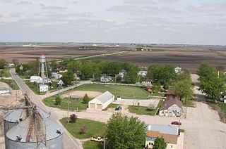
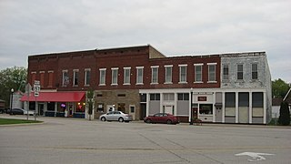
Kamrar is a city in Hamilton County, Iowa, United States. The population was 179 at the time of the 2020 census.

<span class="mw-page-title-main">Eagle Lake, Maine</span> Town in the state of Maine, United States

Eagle Lake is a town in Aroostook County, Maine, United States. The population was 772 at the 2020 census. The town was named by a body of troops heading from Bangor to the Aroostook War for the many eagles that they saw around the lake. A total of 49.0% of the population speaks French, reflecting a trend in Northeastern Maine.

<span class="mw-page-title-main">Merrill, Maine</span> Town in the state of Maine, United States

Merrill is a town in Aroostook County, Maine, United States. The population was 208 at the 2020 census.

Lakeville is a town in Penobscot County, Maine, United States. The population was 104 at the 2020 census.

<span class="mw-page-title-main">East Harwich, Massachusetts</span> Census-designated place in Massachusetts, United States

East Harwich is a census-designated place (CDP) and village in the town of Harwich in Barnstable County, Massachusetts, United States. The population was 4,872 at the 2010 census.

<span class="mw-page-title-main">Oak Park Heights, Minnesota</span> City in Minnesota, United States

Oak Park Heights is a city in Washington County, Minnesota, United States. The population was 4,849 at the 2020 census.

<span class="mw-page-title-main">Alton, Missouri</span> City in Missouri, United States

Alton is a city and the county seat of Oregon County, Missouri, United States. The population was 707 at the 2020 census.

<span class="mw-page-title-main">West Alton, Missouri</span> City in Missouri, United States

West Alton is a city in St. Charles County, Missouri, United States. The population was 359 at the 2020 census. It is located at the tip of the peninsula formed by the confluence of the Missouri and Mississippi Rivers and is directly across Alton, Illinois.

<span class="mw-page-title-main">Grantwood Village, Missouri</span> Town in Missouri, United States

Grantwood Village is a town in St. Louis County, Missouri, United States. The population was 863 at the 2010 census.

<span class="mw-page-title-main">Bancroft, West Virginia</span> Town in West Virginia, United States

Bancroft is a town in Putnam County, West Virginia, United States, along the Kanawha River. The population was 389 at the 2020 census. It is part of the Huntington–Ashland metropolitan area.

<span class="mw-page-title-main">Pine Grove, West Virginia</span> Town in West Virginia, United States

Pine Grove is a town in Wetzel County, West Virginia, United States. The population was 363 at the 2020 census. The community was named for a grove of pine trees near the original town site.

<span class="mw-page-title-main">Jackson, Burnett County, Wisconsin</span> Town in Wisconsin, United States

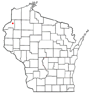
Jackson is a town in Burnett County in the U.S. state of Wisconsin. The population was 773 at the 2010 census.

<span class="mw-page-title-main">Sand Lake, Sawyer County, Wisconsin</span> Town in Wisconsin, United States

Sand Lake is a town in Sawyer County, Wisconsin, United States. The population was 774 at the 2000 census. The census-designated place of Stone Lake is located partially in the town. The unincorporated community of Hauer is also located in the town.

<span class="mw-page-title-main">Trego, Wisconsin</span> Town in Wisconsin, United States

Trego is a town in Washburn County, Wisconsin. The population was 885 at the time of the 2000 census. The census-designated place of Trego is located in the town.

<span class="mw-page-title-main">Bayfield (town), Wisconsin</span> Town in Wisconsin, United States

Bayfield is a town in Bayfield County, Wisconsin, United States. The population was 680 at the 2010 census. The unincorporated communities of Pureair and Salmo are located in the town, as are Eagle Island and Sand Island of the Apostle Islands.

References

  1. 1 2 "US Gazetteer files 2010". United States Census Bureau . Retrieved December 16, 2012.
  2. "Census - Geography Profile: Alton town, Penobscot County, Maine". United States Census Bureau . Retrieved January 22, 2022.
  3. "Census of Population and Housing". Census.gov. Retrieved June 4, 2015.
  4. "U.S. Census website". United States Census Bureau . Retrieved December 16, 2012.
  5. "U.S. Census website". United States Census Bureau . Retrieved January 31, 2008.

45°01′53″N68°43′43″W / 45.03139°N 68.72861°W / 45.03139; -68.72861