Hermon, Maine | |
---|---|
Coordinates: 44°48′6″N68°54′41″W / 44.80167°N 68.91139°W | |
Country | United States |
State | Maine |
County | Penobscot |
Area | |
• Total | 36.81 sq mi (95.34 km2) |
• Land | 35.87 sq mi (92.90 km2) |
• Water | 0.94 sq mi (2.43 km2) |
Elevation | 269 ft (82 m) |
Population (2020) [2] | |
• Total | 6,461 |
• Density | 175.5/sq mi (67.8/km2) |
Time zone | UTC-5 (Eastern (EST)) |
• Summer (DST) | UTC-4 (EDT) |
ZIP code | 04401 |
Area code | 207 |
FIPS code | 23-32510 |
GNIS feature ID | 0582517 |
Website | www |
Hermon is a town in Penobscot County, Maine, United States. The population was 6,461 at the 2020 census. [3]
According to the United States Census Bureau, the town has a total area of 36.81 square miles (95.34 km2), of which 35.87 square miles (92.90 km2) is land and 0.94 square miles (2.43 km2) is water. [1] It is drained by the Souadabscook Stream and Wheeler Stream. Principle bodies of water include Hermon Pond (462 acres), Tracy Pond (47 acres) and George Pond (49 acres).
Hermon is bordered on the northwest by Levant, on the northeast by Glenburn, on the east by Bangor, on the south by Hampden and on the west by Carmel. It is crossed by U.S. Route 2 and Maine State Route 222.
The District No. 5 Schoolhouse (1880) is listed on the National Register of Historic Places. [4]
Census | Pop. | Note | %± |
---|---|---|---|
1820 | 266 | — | |
1830 | 535 | 101.1% | |
1840 | 1,042 | 94.8% | |
1850 | 1,374 | 31.9% | |
1860 | 1,433 | 4.3% | |
1870 | 1,489 | 3.9% | |
1880 | 1,394 | −6.4% | |
1890 | 1,282 | −8.0% | |
1900 | 1,183 | −7.7% | |
1910 | 1,210 | 2.3% | |
1920 | 1,190 | −1.7% | |
1930 | 1,204 | 1.2% | |
1940 | 1,182 | −1.8% | |
1950 | 1,728 | 46.2% | |
1960 | 2,087 | 20.8% | |
1970 | 2,376 | 13.8% | |
1980 | 3,170 | 33.4% | |
1990 | 3,755 | 18.5% | |
2000 | 4,437 | 18.2% | |
2010 | 5,416 | 22.1% | |
2020 | 6,461 | 19.3% | |
U.S. Decennial Census [5] |
As of the census [2] of 2010, there were 5,416 people, 2,075 households, and 1,548 families living in the town. The population density was 151.0 inhabitants per square mile (58.3/km2). There were 2,210 housing units at an average density of 61.6 per square mile (23.8/km2). The racial makeup of the town was 97.7% White, 0.4% African American, 0.4% Native American, 0.4% Asian, 0.1% from other races, and 1.0% from two or more races. Hispanic or Latino of any race were 1.0% of the population.
There were 2,075 households, of which 33.6% had children under the age of 18 living with them, 62.0% were married couples living together, 8.6% had a female householder with no husband present, 4.0% had a male householder with no wife present, and 25.4% were non-families. 18.0% of all households were made up of individuals, and 7.3% had someone living alone who was 65 years of age or older. The average household size was 2.61 and the average family size was 2.95.
The median age in the town was 40.4 years. 23.7% of residents were under the age of 18; 7.3% were between the ages of 18 and 24; 26.6% were from 25 to 44; 30.4% were from 45 to 64; and 12% were 65 years of age or older. The gender makeup of the town was 49.3% male and 50.7% female.
As of the census [6] of 2000, there were 4,437 people, 1,666 households, and 1,294 families living in the town. The population density was 123.5 inhabitants per square mile (47.7/km2). There were 1,748 housing units at an average density of 48.7 per square mile (18.8/km2). The racial makeup of the town was 98.08% White, 0.16% African American, 0.29% Native American, 0.43% Asian, 0.02% Pacific Islander, 0.09% from other races, and 0.92% from two or more races. Hispanic or Latino of any race were 0.52% of the population.
There were 1,666 households, out of which 39.0% had children under the age of 18 living with them, 65.5% were married couples living together, 8.8% had a female householder with no husband present, and 22.3% were non-families. 16.7% of all households were made up of individuals, and 6.5% had someone living alone who was 65 years of age or older. The average household size was 2.66 and the average family size was 2.98.
In the town, the population was spread out, with 27.1% under the age of 18, 6.0% from 18 to 24, 32.0% from 25 to 44, 25.0% from 45 to 64, and 9.9% who were 65 years of age or older. The median age was 37 years. For every 100 females, there were 94.2 males. For every 100 females age 18 and over, there were 91.9 males.
The median income for a household in the town was $47,206, and the median income for a family was $50,500. Males had a median income of $34,620 versus $23,958 for females. The per capita income for the town was $19,714. About 4.4% of families and 6.6% of the population were below the poverty line, including 6.1% of those under age 18 and 5.4% of those age 65 or over.
West Ocean City is a census-designated place (CDP) in Worcester County, Maryland, United States. The population was 4,375 at the 2010 census. It is part of the Salisbury, Maryland-Delaware Metropolitan Statistical Area.
Coloma is a city in Berrien County in the U.S. state of Michigan. The population was 1,465 at the 2020 census.
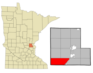
Stanford Township is a township in Isanti County, Minnesota, United States. The population was 2,075 at the 2000 census.
Nashwauk Township is a township in Itasca County, Minnesota, United States. The population was 1,681 at the 2010 census.
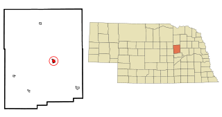
Albion is a city in and the county seat of Boone County, Nebraska, United States. The population was 1,650 at the 2010 census.
New Scotland is a town in Albany County, New York, United States. The population was 9,096 at the 2020 census.
Union City is a village in Darke County, Ohio, United States. The population was 1,582 at the 2020 census. It is directly across the state line from its twin city of Union City, Indiana.
Sheffield is a village in Lorain County, Ohio, United States, along the Black River. The population was 4,135 at the 2020 census. It is part of the Cleveland metropolitan area.
Darlington is a borough in northwestern Beaver County, Pennsylvania, United States. The population was 249 at the 2020 census. It is a part of the Pittsburgh metropolitan area.
Boggs Township is a township in Centre County, Pennsylvania, United States. It is part of the State College, Pennsylvania Metropolitan Statistical Area. It is located north of Bellefonte at approximately 40°54′48″N77°45′53″W. As of the 2010 census, the township population was 2,985.
Boggs Township is a township in Clearfield County, Pennsylvania, United States. The population was 1,666 at the 2020 census.
East Lackawannock Township is a township in Mercer County, Pennsylvania, United States. The population was 1,666 at the 2020 census, a decline from the figure of 1,682 in 2010.
Confluence is a borough in Somerset County, Pennsylvania, United States. It is part of the Johnstown, Pennsylvania, Metropolitan Statistical Area. The population was 724 at the 2020 census.
Overfield Township is a township in Wyoming County, Pennsylvania, United States. The population was 1,427 at the 2020 census. Lake Winola is located in Overfield Township.
Redwood is an unincorporated community and census-designated place (CDP) in Guadalupe County, Texas, United States. The population was 4,003 at the 2020 census, a decline from the figure of 4,338 tabulated in 2010. It is part of the San Antonio Metropolitan Statistical Area.
Pratt is a town in Kanawha County, West Virginia, United States, along the Kanawha River. The population was 482 at the 2020 census.
Vienna is a town in Dane County, Wisconsin, United States. The population was 1,666 at the 2020 census. The unincorporated community of Norway Grove is located in the town.
Auburn is a town in Fond du Lac County, Wisconsin, United States. The population was 2,075 at the 2000 census. The unincorporated communities of New Fane and New Prospect are located within Auburn. The ghost town of New Cassel was also located in Auburn.
Bar Nunn is a town in Natrona County, Wyoming, United States. It is a part of the Casper, Wyoming Metropolitan Statistical Area. The population was 2,213 at the 2010 census. It was incorporated in 1980.
Hermon is a town in St. Lawrence County, New York, United States. The population was 1,108 at the 2010 census. Hermon is named after Mount Hermon in Israel, which is the name corresponding to Mount Jabal al-Sheikh in Syria. The town contains a hamlet also called Hermon, and is in the south-central part of the county, southwest of Canton.