Orland, Maine

Last updated

Orland, Maine
USA Maine location map.svg
Red pog.svg
Orland
Usa edcp location map.svg
Red pog.svg
Orland
Coordinates: 44°34′26″N68°41′11″W / 44.57389°N 68.68639°W / 44.57389; -68.68639
Country United States
State Maine
County Hancock
VillagesOrland
East Orland
South Orland
Area
[1]
  Total52.87 sq mi (136.93 km2)
  Land47.04 sq mi (121.83 km2)
  Water5.83 sq mi (15.10 km2)
Elevation
259 ft (79 m)
Population
 (2020)
  Total2,221
  Density47/sq mi (18.2/km2)
Time zone UTC-5 (Eastern (EST))
  Summer (DST) UTC-4 (EDT)
ZIP code
04472
Area code 207
FIPS code 23-55505
GNIS feature ID0582650

Orland is a town in Hancock County, Maine, United States. The population was 2,221 at the 2020 census. [2]

Contents

Geography

According to the United States Census Bureau, the town has a total area of 52.87 square miles (136.93 km2), of which 47.04 square miles (121.83 km2) is land and 5.83 square miles (15.10 km2) is water. [1]

Demographics

Historical population
CensusPop.Note
1800 294
1810 48063.3%
1820 61027.1%
1830 97559.8%
1840 1,38141.6%
1850 1,57914.3%
1860 1,78713.2%
1870 1,701−4.8%
1880 1,689−0.7%
1890 1,390−17.7%
1900 1,251−10.0%
1910 1,224−2.2%
1920 910−25.7%
1930 891−2.1%
1940 1,01513.9%
1950 1,15513.8%
1960 1,1953.5%
1970 1,3079.4%
1980 1,64525.9%
1990 1,8059.7%
2000 2,13418.2%
2010 2,2254.3%
2020 2,221−0.2%
U.S. Decennial Census [3]

2010 census

At the 2010 census there were 2,225 people, 976 households, and 627 families living in the town. The population density was 47.3 inhabitants per square mile (18.3/km2). There were 1,470 housing units at an average density of 31.3 per square mile (12.1/km2). The racial makeup of the town was 97.3% White, 0.1% African American, 0.5% Native American, 0.3% Asian, 0.5% from other races, and 1.3% from two or more races. Hispanic or Latino of any race were 1.2%. [4]

Of the 976 households 24.3% had children under the age of 18 living with them, 50.7% were married couples living together, 9.0% had a female householder with no husband present, 4.5% had a male householder with no wife present, and 35.8% were non-families. 27.9% of households were one person and 8% were one person aged 65 or older. The average household size was 2.25 and the average family size was 2.70.

The median age in the town was 47.3 years. 17.3% of residents were under the age of 18; 7.9% were between the ages of 18 and 24; 20.5% were from 25 to 44; 38.5% were from 45 to 64; and 15.7% were 65 or older. The gender makeup of the town was 50.0% male and 50.0% female.

2000 census

At the 2000 census there were 2,127 people, 867 households, and 630 families living in the town. The population density was 45.5 inhabitants per square mile (17.6/km2). There were 1,253 housing units at an average density of 26.7 per square mile (10.3/km2). The racial makeup of the town was 98.27% White, 0.14% Native American, 0.23% Asian, 0.09% from other races, and 1.27% from two or more races. Hispanic or Latino of any race were 0.37%. [5]

Of the 880 households 31.5% had children under the age of 18 living with them, 57.4% were married couples living together, 9.7% had a female householder with no husband present, and 28.4% were non-families. 22.2% of households were one person and 6.5% were one person aged 65 or older. The average household size was 2.42 and the average family size was 2.82.

The age distribution was 24.0% under the age of 18, 5.7% from 18 to 24, 29.6% from 25 to 44, 27.8% from 45 to 64, and 12.8% 65 or older. The median age was 40 years. For every 100 females, there were 98.9 males. For every 100 females age 18 and over, there were 92.3 males.

The median household income was $39,345 and the median family income was $45,875. Males had a median income of $36,435 versus $23,571 for females. The per capita income for the town was $19,551. About 8.5% of families and 11.2% of the population were below the poverty line, including 18.3% of those under age 18 and 4.2% of those age 65 or over.

Notable people

Town government

Selectmen/Town Meeting

Related Research Articles

<span class="mw-page-title-main">Orland, California</span> City in California, United States

Orland is a city in Glenn County, California. The population as of the 2020 census was 8,298. The population was 7,291 at the 2010 census, up from 6,281 at the 2000 census, making Orland the most populous and fastest growing city in Glenn County. Orland is located 16 miles (26 km) north of Willows, at an elevation of 259 feet. Interstate 5, (north–south) passes west of the downtown area while State Route 32 (east–west) passes through downtown.

<span class="mw-page-title-main">Orland, Indiana</span> Town in Indiana, United States

Orland is a town located in the northwest corner of Steuben County, Indiana in Millgrove Township at the intersection of State Road 120 and State Road 327. The population was 434 at the 2010 census.

<span class="mw-page-title-main">Winthrop, Iowa</span> City in Iowa, United States

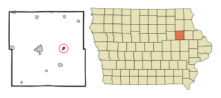
Winthrop is a city in Buchanan County, Iowa, United States. The population was 823 at the time of the 2020 census.

<span class="mw-page-title-main">Mapleton, Maine</span> Town in the state of Maine, United States

Mapleton is a town in Aroostook County, Maine, United States. The population was 1,886 at the 2020 census.

<span class="mw-page-title-main">Oakfield, Maine</span> Town in the state of Maine, United States

Oakfield is a town in Aroostook County, Maine, United States. The population was 661 at the 2020 census. The village of Oakfield, listed as a census-designated place, is in the northwestern corner of the town.

<span class="mw-page-title-main">Sherman, Maine</span> Town in the state of Maine, United States

Sherman is a town in Aroostook County, Maine, United States. The population was 815 at the 2020 census.

<span class="mw-page-title-main">Westfield, Maine</span> Town in the state of Maine, United States

Westfield is a town in Aroostook County, Maine, United States. The population was 455 at the 2020 census.

<span class="mw-page-title-main">Standish, Maine</span> Town in the state of Maine, United States

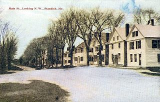
Standish is a town in Cumberland County, Maine, United States. The population was 10,244 at the 2020 census. It includes the villages of Standish Corner, Sebago Lake Village and Steep Falls, and the localities known as Richville, Elmwood, Standish Neck and Two Trails. Standish is part of the Portland-South Portland-Biddeford, Maine metropolitan statistical area.

Otis is a town in Hancock County, Maine, United States. The population was 673 at the 2020 census.

<span class="mw-page-title-main">Vienna, Maine</span> Town in the state of Maine, United States

Vienna is a town in Kennebec County, Maine, United States. The population was 578 at the 2020 census.

Bradley is a town in Penobscot County, Maine, United States. It is part of the Bangor Metropolitan Statistical Area. The population was 1,532 at the 2020 census. The village of Bradley is in the northwestern corner of the town.

Detroit is a town in Somerset County, Maine, United States. The population was 885 at the 2020 census.

<span class="mw-page-title-main">Burnham, Maine</span> Town in the state of Maine, United States

Burnham is a town in Waldo County, Maine, United States. The population was 1,096 at the 2020 census.

<span class="mw-page-title-main">Whitneyville, Maine</span> Town in the state of Maine, United States

Whitneyville is a town in Washington County, Maine, United States. The town was named after Colonel Joseph Whitney, a mill owner. The population was 202 at the 2020 census.

<span class="mw-page-title-main">Mackinaw Township, Michigan</span> Civil township in Michigan, United States

Mackinaw Township is a civil township of Cheboygan County in the U.S. state of Michigan. The population was 491 at the 2020 census.

<span class="mw-page-title-main">Nenahnezad, New Mexico</span> CDP in New Mexico, United States

Nenahnezad is a census-designated place (CDP) in San Juan County, New Mexico, United States. The population was 726 at the 2000 census. Nenahnezad is a Chapter community just to the south of Fruitland, between the towns of Farmington and Shiprock. It is part of the Farmington Metropolitan Statistical Area.

<span class="mw-page-title-main">North Hills, West Virginia</span> Town in West Virginia, United States

North Hills is a town in Wood County, West Virginia, United States. It is a suburb of Parkersburg. The population was 837 at the 2020 census. North Hills was incorporated on February 15, 1979.

<span class="mw-page-title-main">Luck, Wisconsin</span> Village in Wisconsin, United States

Luck is a village in Polk County, Wisconsin, United States. The population was 1,119 at the 2010 census.

Bucksport is a census-designated place (CDP) in the town of Bucksport in Hancock County, Maine, United States. The population was 2,885 at the 2010 census, down from 2,970 at the 2000 census.

<span class="mw-page-title-main">East Millinocket, Maine</span> Town in the state of Maine, United States

East Millinocket is a town in Penobscot County, Maine, United States. The population was 1,572 at the 2020 census.

References

  1. 1 2 "US Gazetteer files 2010". United States Census Bureau . Retrieved December 16, 2012.
  2. "Census - Geography Profile: Orland town, Hancock County, Maine" . Retrieved January 17, 2022.
  3. "Census of Population and Housing". Census.gov. Retrieved June 4, 2015.
  4. "U.S. Census website". United States Census Bureau . Retrieved December 16, 2012.
  5. "U.S. Census website". United States Census Bureau . Retrieved January 31, 2008.

44°34′13″N68°44′09″W / 44.57028°N 68.73583°W / 44.57028; -68.73583