Mount Desert, Maine

Last updated

Mount Desert, Maine
Northeast Harbor, Mount Desert, Maine 2012.JPG
Village of Northeast Harbor
Seal of Mount Desert, Maine.gif
USA Maine location map.svg
Red pog.svg
Mount Desert
Location within the state of Maine
Usa edcp location map.svg
Red pog.svg
Mount Desert
Mount Desert (the United States)
Coordinates: 44°19′50″N68°19′4″W / 44.33056°N 68.31778°W / 44.33056; -68.31778
Country United States
State Maine
County Hancock
Settled1762
Incorporated (town)February 17, 1789
VillagesHall Quarry
Northeast Harbor
Otter Creek
Pretty Marsh
Seal Harbor
Somesville
Area
[1]
  Total54.88 sq mi (142.14 km2)
  Land36.88 sq mi (95.52 km2)
  Water18.00 sq mi (46.62 km2)
Elevation
180 ft (55 m)
Population
 (2020)
  Total2,146
  Density58/sq mi (22.5/km2)
Time zone UTC-5 (Eastern (EST))
  Summer (DST) UTC-4 (EDT)
ZIP code
04660
Area code 207
FIPS code 23-47630
GNIS feature ID0582611
Website mtdesert.org
Mount Desert Town Hall Mount Desert, ME, Town Hall IMG 2155.JPG
Mount Desert Town Hall

Mount Desert is a town on Mount Desert Island in Hancock County, Maine, United States. The population was 2,146 at the 2020 census. [2] Incorporated in 1789, the town currently encompasses the villages of Otter Creek, Seal Harbor, Northeast Harbor, Somesville, Hall Quarry, and Pretty Marsh.

Contents

Geography

According to the United States Census Bureau, the town has a total area of 54.88 square miles (142.14 km2), of which 36.88 square miles (95.52 km2) is land and 18.00 square miles (46.62 km2) is water. [1]

Demographics

Historical population
CensusPop.Note
1790 744
1800 721−3.1%
1810 1,04745.2%
1820 1,34928.8%
1830 1,60318.8%
1840 1,88717.7%
1850 782−58.6%
1860 91617.1%
1870 9180.2%
1880 1,01710.8%
1890 1,35533.2%
1900 1,60018.1%
1910 1,569−1.9%
1920 1,497−4.6%
1930 2,02235.1%
1940 2,0471.2%
1950 1,776−13.2%
1960 1,663−6.4%
1970 1,659−0.2%
1980 2,06324.4%
1990 1,899−7.9%
2000 2,10911.1%
2010 2,053−2.7%
2020 2,1464.5%
U.S. Decennial Census [3]

2010 census

As of the census [4] of 2010, there were 2,053 people, 984 households, and 586 families living in the town. The population density was 55.7 inhabitants per square mile (21.5/km2). There were 2,287 housing units at an average density of 62.0 per square mile (23.9/km2). The racial makeup of the town was 98.1% White, 0.3% African American, 0.1% Native American, 0.7% Asian, 0.1% from other races, and 0.7% from two or more races. Hispanic or Latino of any race were 0.9% of the population.

There were 984 households, of which 20.9% had children under the age of 18 living with them, 51.0% were married couples living together, 5.7% had a female householder with no husband present, 2.8% had a male householder with no wife present, and 40.4% were non-families. 32.7% of all households were made up of individuals, and 11.8% had someone living alone who was 65 years of age or older. The average household size was 2.09 and the average family size was 2.64.

The median age in the town was 50.7 years. 16.5% of residents were under the age of 18; 5% were between the ages of 18 and 24; 19.2% were from 25 to 44; 37.8% were from 45 to 64; and 21.4% were 65 years of age or older. The gender makeup of the town was 48.2% male and 51.8% female.

2000 census

As of the census [5] of 2000, there were 2,109 people, 962 households, and 583 families living in the town. The population density was 57.1 inhabitants per square mile (22.0/km2). There were 1,900 housing units at an average density of 51.5 per square mile (19.9/km2). The racial makeup of the town was 98.62% White, 0.19% African American, 0.09% Native American, 0.09% Asian, 0.14% Pacific Islander, 0.24% from other races, and 0.62% from two or more races. Hispanic or Latino of any race were 0.62% of the population.

There were 962 households, out of which 23.7% had children under the age of 18 living with them, 51.1% were married couples living together, 6.8% had a female householder with no husband present, and 39.3% were non-families. 31.2% of all households were made up of individuals, and 13.0% had someone living alone who was 65 years of age or older. The average household size was 2.19 and the average family size was 2.76.

In the town, the population was spread out, with 20.6% under the age of 18, 4.2% from 18 to 24, 28.0% from 25 to 44, 29.5% from 45 to 64, and 17.7% who were 65 years of age or older. The median age was 44 years. For every 100 females, there were 90.2 males. For every 100 females age 18 and over, there were 85.6 males.

The median income for a household in the town was $41,321, and the median income for a family was $54,375. Males had a median income of $35,189 versus $27,358 for females. The per capita income for the town was $25,709. About 3.2% of families and 5.1% of the population were below the poverty line, including 4.2% of those under age 18 and 9.3% of those age 65 or over.

Education

Mount Desert is part of the Mount Desert Island Regional School System.

Schools in the district include Mount Desert Island High School, Conners Emerson School, Trenton Elementary School, Pemetic Elementary School, Frenchboro Elementary School, Tremont Consolidated School, Mount Desert Elementary School, Swan's Island Elementary School and Islesford Elementary School. [6]

Notable people

See also

Related Research Articles

<span class="mw-page-title-main">Saratoga, Wyoming</span> Town in Wyoming, United States

Saratoga is a town in Carbon County, Wyoming, United States. The population was 1,690 at the 2010 census.

<span class="mw-page-title-main">Mount Vernon, Alabama</span> Town in Alabama, United States

Mount Vernon is a town in Mobile County, Alabama, United States. It is part of the Mobile metropolitan area. It incorporated in 1959. At the 2020 census the population was 1,354.

<span class="mw-page-title-main">Westbrook, Connecticut</span> Town in Connecticut, United States

Westbrook is a town in Middlesex County, Connecticut, United States. The town is part of the Lower Connecticut River Valley Planning Region. The population was 6,769 at the 2020 census. The town center is classified by the U.S. Census Bureau as a census-designated place (CDP).

<span class="mw-page-title-main">Griffin, Indiana</span> Town in Indiana, United States

Griffin is a town in Bethel Township, Posey County, in the U.S. state of Indiana. The population was 172 at the 2010 census.

<span class="mw-page-title-main">Maloy, Iowa</span> City in Iowa, United States

Maloy is a city in southwest Ringgold County, Iowa, United States, along the Little Platte River. The population was 22 at the time of the 2020 census.

<span class="mw-page-title-main">Blue Grass, Iowa</span> City in Iowa, United States

Blue Grass is a city in Muscatine and Scott counties in the U.S. state of Iowa. The population was 1,666 as of 2020.

<span class="mw-page-title-main">St. Francis, Maine</span> Town in the state of Maine, United States

St. Francis is a town in Aroostook County, Maine, United States on the Canada–United States border at the junction of the St. Francis River and the Saint John River. The population was 438 at the 2020 census. First settled by English speakers from southern Maine, the original population has been supplanted by French-speaking Acadians.

Frenchboro is a town in Hancock County, Maine, United States, and a village within this town located on Long Island, southeast of Swans Island. The population was 29 at the 2020 census. The town is accessible by state ferry service from Bass Harbor.

<span class="mw-page-title-main">Hancock, Maine</span> Town in the state of Maine, United States

Hancock is a town in Hancock County, Maine, United States. The population was 2,466 at the 2020 census. Located on the mainland at the head of Frenchman Bay, Hancock has commanding views of Mount Desert Island.

<span class="mw-page-title-main">Southwest Harbor, Maine</span> Town in the state of Maine, United States

Southwest Harbor is a town in Hancock County, Maine, United States. Located on Mount Desert Island, the population was 1,756 at the 2020 census. The municipality contains within it the villages of Southwest Harbor, Manset, Seawall, Wonderland, and Pemetic Hills.

<span class="mw-page-title-main">Tremont, Maine</span> Town in the state of Maine, United States

Tremont is a town in Hancock County, Maine, United States. It is located on the southwestern side of Mount Desert Island, known to locals as "the quiet side."

<span class="mw-page-title-main">Mount Vernon, Maine</span> Town in the state of Maine, United States

Mount Vernon is a town in Kennebec County, Maine, United States. The population was 1,721 at the 2020 census. Mount Vernon is included in the Augusta, Maine micropolitan New England City and Town Area. A popular recreation spot in central Maine, the northern area of Mount Vernon is part of the Belgrade Lakes Region, while the southern area is part of the Winthrop Lakes Region.

Jonesboro is a town in Washington County, Maine, United States. The town was named for John Coffin Jones, a landholder. The population was 587 at the 2020 census.

<span class="mw-page-title-main">Des Lacs, North Dakota</span> City in North Dakota, United States

Des Lacs is a city in Ward County, North Dakota, United States. The population was 185 at the 2020 census. It is part of the Minot Micropolitan Statistical Area. Des Lacs was founded in 1888, named after the Riviere de Lacs, from the French for "River [of] The Lakes."

<span class="mw-page-title-main">Mount Healthy, Ohio</span> City in Ohio, United States

Mount Healthy is a city in Hamilton County, Ohio, United States. It is a suburb of Cincinnati. The population was 6,996 at the 2020 census.

<span class="mw-page-title-main">Oakland, Douglas County, Wisconsin</span> Town in Wisconsin, United States

Oakland is a town in Douglas County, Wisconsin, United States. The population was 1,144 at the 2000 census.

<span class="mw-page-title-main">Summit, Douglas County, Wisconsin</span> Town in Wisconsin, United States

Summit is a town in Douglas County, Wisconsin, United States. The population was 1,042 at the 2000 census. The unincorporated communities of Chaffey, Foxboro, and Patzau are located in the town.

<span class="mw-page-title-main">Byron, Wyoming</span> Town in Big Horn County, Wyoming, United States

Byron is a town in Big Horn County, Wyoming, United States. The population was 562 according to the 2020 census.

<span class="mw-page-title-main">Deaver, Wyoming</span> Town in Wyoming, United States

Deaver is a town in Big Horn County, Wyoming, United States. The population was 178 at the 2010 census.

<span class="mw-page-title-main">Millersburg, Indiana</span> Town in Indiana, United States

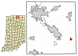
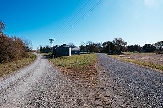
Millersburg is a town in Clinton and Benton townships, Elkhart County, Indiana, United States. The population was 903 at the 2010 census.

References

  1. 1 2 "US Gazetteer files 2010". United States Census Bureau . Retrieved December 16, 2012.
  2. "Census - Geography Profile: Mount Desert town, Hancock County, Maine" . Retrieved January 17, 2022.
  3. "Census of Population and Housing". Census.gov. Retrieved June 4, 2015.
  4. "U.S. Census website". United States Census Bureau . Retrieved December 16, 2012.
  5. "U.S. Census website". United States Census Bureau . Retrieved January 31, 2008.
  6. "Mount Desert Island". Mount Desert Island. Retrieved August 6, 2012.