Gouldsboro, Maine

Last updated

Gouldsboro, Maine
Library GouldsboroME.jpg
West Gouldsboro Village Library
USA Maine location map.svg
Red pog.svg
Gouldsboro
Usa edcp location map.svg
Red pog.svg
Gouldsboro
Coordinates: 44°25′47″N68°2′38″W / 44.42972°N 68.04389°W / 44.42972; -68.04389
CountryUnited States
State Maine
County Hancock
VillagesGouldsboro
Ashville (part)
Birch Harbor
Corea
Prospect Harbor
South Gouldsboro
West Gouldsboro
Government
  Town Manager Yvonne Wilkinson - Interim
Area
[1]
  Total98.99 sq mi (256.38 km2)
  Land46.17 sq mi (119.58 km2)
  Water52.82 sq mi (136.80 km2)
Elevation
33 ft (10 m)
Population
 (2020)
  Total1,703
  Density37/sq mi (14.2/km2)
Time zone UTC-5 (Eastern (EST))
  Summer (DST) UTC-4 (EDT)
ZIP code
04607
Area code 207
FIPS code 23-28450
GNIS feature ID0582494
Website http://www.gouldsborotown.com/

Gouldsboro is a town and municipality in Hancock County, Maine, United States on the Schoodic Peninsula. The town was named for Robert Gould, a landholder in the town. [2] The town has many historically separate fishing villages, summer colonies and communities, including Birch Harbor, Prospect Harbor, South Gouldsboro, West Gouldsboro, Summer Harbor, Wonsqueak Harbor, Bunker's Harbor, Chicken Mill, Jones' Pond, Westbay, and Corea. [3] The population was 1,703 at the 2020 census. [4]

Contents

Geography

According to the United States Census Bureau, the town has a total area of 98.99 square miles (256.38 km2), of which 46.17 square miles (119.58 km2) is land and 52.82 square miles (136.80 km2) is water. [1]

Demographics

Historical population
CensusPop.Note
1790 267
1800 37941.9%
1810 47124.3%
1820 56018.9%
1830 88057.1%
1840 1,19836.1%
1850 1,40016.9%
1860 1,71722.6%
1870 1,709−0.5%
1880 1,8256.8%
1890 1,709−6.4%
1900 1,259−26.3%
1910 1,3497.1%
1920 1,282−5.0%
1930 1,115−13.0%
1940 1,068−4.2%
1950 1,1689.4%
1960 1,100−5.8%
1970 1,31019.1%
1980 1,57420.2%
1990 1,98626.2%
2000 1,941−2.3%
2010 1,737−10.5%
2020 1,703−2.0%
U.S. Decennial Census [5]

2010 census

As of the census [6] of 2010, there were 1,737 people, 773 households, and 528 families living in the town. The population density was 37.6 inhabitants per square mile (14.5/km2). There were 1,442 housing units at an average density of 31.2 per square mile (12.0/km2). The racial makeup of the town was 97.8% White, 0.2% African American, 0.3% Native American, 0.2% Asian, 0.1% Pacific Islander, 0.8% from other races, and 0.6% from two or more races. Hispanic or Latino of any race were 2.4% of the population.

There were 773 households, of which 21.6% had children under the age of 18 living with them, 56.0% were married couples living together, 7.8% had a female householder with no husband present, 4.5% had a male householder with no wife present, and 31.7% were non-families. 26.3% of all households were made up of individuals, and 12.7% had someone living alone who was 65 years of age or older. The average household size was 2.25 and the average family size was 2.66.

The median age in the town was 50.3 years. 17.2% of residents were under the age of 18; 6.1% were between the ages of 18 and 24; 18.4% were from 25 to 44; 35.1% were from 45 to 64; and 23.1% were 65 years of age or older. The gender makeup of the town was 50.3% male and 49.7% female.

2000 census

As of the census [7] of 2000, there were 1,941 people, 801 households, and 539 families living in the town. The population density was 42.1 inhabitants per square mile (16.3/km2). There were 1,328 housing units at an average density of 28.8 per square mile (11.1/km2). The racial makeup of the town was 96.39% White, 0.67% African American, 0.82% Native American, 0.21% Asian, 0.26% Pacific Islander, 0.52% from other races, and 1.13% from two or more races. Hispanic or Latino of any race were 1.85% of the population.

There were 801 households, out of which 25.0% had children under the age of 18 living with them, 58.8% were married couples living together, 5.5% had a female householder with no husband present, and 32.7% were non-families. 27.5% of all households were made up of individuals, and 13.4% had someone living alone who was 65 years of age or older. The average household size was 2.31 and the average family size was 2.78.

In the town, the population was spread out, with 19.8% under the age of 18, 7.5% from 18 to 24, 26.7% from 25 to 44, 28.6% from 45 to 64, and 17.3% who were 65 years of age or older. The median age was 42 years. For every 100 females, there were 106.7 males. For every 100 females age 18 and over, there were 100.0 males.

The median income for a household in the town was $36,542, and the median income for a family was $43,864. Males had a median income of $25,076 versus $19,563 for females. The per capita income for the town was $18,203. About 7.0% of families and 10.4% of the population were below the poverty line, including 14.9% of those under age 18 and 8.5% of those age 65 or over.

Corea

Corea is one of the many villages that comprise the town of Gouldsboro. In the early 1800s, Corea was referred to as Indian Harbor, as it was occupied by the Native American Passamaquoddy. The name of the town changed from Indian Harbor to Corea in the year 1896 with the construction of the village's first post office. [8] The primary industry of Corea is lobster fishing.

Notable people

Related Research Articles

<span class="mw-page-title-main">Hancock County, Maine</span> County in Maine, United States

Hancock County is a county located in the U.S. state of Maine. As of the 2020 census, the population was 55,478. Its county seat is Ellsworth. The county was incorporated on June 25, 1789, and named for John Hancock, the first governor of the Commonwealth of Massachusetts.

<span class="mw-page-title-main">St. Francis, Maine</span> Town in the state of Maine, United States

St. Francis is a town in Aroostook County, Maine, United States on the Canada–United States border at the junction of the St. Francis River and the Saint John River. The population was 438 at the 2020 census. First settled by English speakers from southern Maine, the original population has been supplanted by French-speaking Acadians.

<span class="mw-page-title-main">Eustis, Maine</span> Town in Maine, United States

Eustis is a town in Franklin County, Maine, United States. The population was 641 at the 2020 census. Eustis, which includes the village of Stratton, is a popular recreation area.

<span class="mw-page-title-main">Brooklin, Maine</span> Town in the state of Maine, United States

Brooklin is a town in Hancock County, Maine, United States. The population was 827 at the 2020 census.

<span class="mw-page-title-main">Franklin, Maine</span> Town in the state of Maine, United States

Franklin is a town in Hancock County, Maine, United States. The population was 1,567 at the 2020 census. The town's namesake is Benjamin Franklin.

<span class="mw-page-title-main">Hancock, Maine</span> Town in the state of Maine, United States

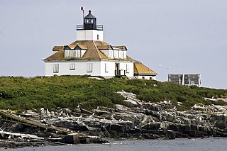
Hancock is a town in Hancock County, Maine, United States. The population was 2,466 at the 2020 census. Located on the mainland at the head of Frenchman Bay, Hancock has commanding views of Mount Desert Island.

<span class="mw-page-title-main">Mount Desert, Maine</span> Town in the state of Maine, United States

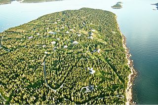
Mount Desert is a town on Mount Desert Island in Hancock County, Maine, United States. The population was 2,146 at the 2020 census. Incorporated in 1789, the town currently encompasses the villages of Otter Creek, Seal Harbor, Northeast Harbor, Somesville, Hall Quarry, and Pretty Marsh.

<span class="mw-page-title-main">Penobscot, Maine</span> Town in the state of Maine, United States

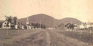
Penobscot is a town in Hancock County, Maine, United States. The Bagaduce River flows through the town. The population was 1,136 at the 2020 census.

Sullivan is a town in Hancock County, Maine, United States. The population was 1,219 at the 2020 census. The town was named for Daniel Sullivan, an early settler. Colloquially referred to as "Sully" or "the Sullivans"—like many Maine municipalities composed of villages with geographic designations of the town proper—the municipality was incorporated in 1789. Located in the Upper Schoodic Peninsula sub-region of Maine's Downeast Acadia region, the municipality has been known as "Waukeag", "New Bristol", and later Sullivan; and once included the nearby communities of Hancock, Sorrento, and what would later be Township 7, South & Middle Districts. Once home to abundant granite quarries, the town of Sullivan is now a residential community for nearby Ellsworth and Mount Desert Island. Located along U.S. Route 1, the Taunton River, and Hog Bay, Sullivan is home to a reversing tidal falls and many scenic turnouts that dot the Schoodic National Scenic Byway along the Upper Schoodic Peninsula.

<span class="mw-page-title-main">Tremont, Maine</span> Town in the state of Maine, United States

Tremont is a town in Hancock County, Maine, United States. It is located on the southwestern side of Mount Desert Island, known to locals as "the quiet side."

<span class="mw-page-title-main">Trenton, Maine</span> Town in the state of Maine, United States

Trenton is a town in Hancock County, Maine, United States, near Acadia National Park. The population was 1,584 at the 2020 census. Hancock County-Bar Harbor Airport is located in Trenton.

<span class="mw-page-title-main">Winter Harbor, Maine</span> Town in the state of Maine, United States

Winter Harbor is a town on the Schoodic Peninsula in Hancock County, Maine, United States. The population was 461 at the 2020 census. The town is located just outside the Schoodic Peninsula portion of Acadia National Park and is due east of the town of Bar Harbor and Ellsworth. Winter Harbor was once the location of a US Naval Station, NSGA-WH, which closed in the mid-2000s, and is now home to the Schoodic Institute’s Education and Research Center.

<span class="mw-page-title-main">Gilead, Maine</span> Town in the state of Maine, United States

Gilead is a town in Oxford County, Maine, United States. Upon incorporation in 1804, it was named for the large quantity of Balm of Gilead trees in the town center. The population was 195 at the 2020 census.

<span class="mw-page-title-main">Charleston, Maine</span> Town in the state of Maine, United States

Charleston is a town in Penobscot County, Maine, United States. It is part of the Bangor Metropolitan Statistical Area. The population was 1,558 at the 2020 census. Charleston includes the village of West Charleston and is home to the Higgins Classical Institute, a Christian school.

Corinth is a town in Penobscot County, Maine, United States. The population was 2,900 at the 2020 census.

Garland is a town in Penobscot County, Maine, United States. The population was 1,026 at the 2020 census.

Detroit is a town in Somerset County, Maine, United States. The population was 885 at the 2020 census.

<span class="mw-page-title-main">Smithfield, Maine</span> Town in the state of Maine, United States

Smithfield is a town in Somerset County, Maine, United States. The population was 925 at the 2020 census. The town was incorporated on February 29, 1840, making it the only town in Maine incorporated on Leap Day. The town was named after the Rev. Henry Smith, an early settler.

<span class="mw-page-title-main">Cutler, Maine</span> Town in the state of Maine, United States

Cutler is a town in Washington County, Maine, United States. The town was named after Joseph Cutler, an early settler, who hailed from Newburyport, Massachusetts. The population was 524 at the 2020 census.

Meddybemps is a town in Washington County, Maine, United States. The population was 139 at the 2020 census.

References

  1. 1 2 "US Gazetteer files 2010". United States Census Bureau . Retrieved December 16, 2012.
  2. "Profile for Gouldsboro, Maine". ePodunk . Retrieved April 18, 2010.
  3. 1 2 Maine League of Historical Societies and Museums (1970). Doris A. Isaacson (ed.). Maine: A Guide 'Down East'. Rockland, Me: Courier-Gazette, Inc. pp. 276–277.
  4. "Census - Geography Profile: Gouldsboro town, Hancock County, Maine" . Retrieved January 19, 2022.
  5. "Census of Population and Housing". Census.gov. Retrieved June 4, 2015.
  6. "U.S. Census website". United States Census Bureau . Retrieved December 16, 2012.
  7. "U.S. Census website". United States Census Bureau . Retrieved January 31, 2008.
  8. The Daughters of Liberty, Gouldsboro, ME. Historical researches of Gouldsboro, Maine (1904). Daughters of Liberty, Gouldsboro, ME, 1904. p. 101
  9. Ludington, Townsend. Marsden Hartley: The Biography of an American Artist. Cornell University, 1998.p. 278

Further reading

44°28′42″N68°02′18″W / 44.47833°N 68.03833°W / 44.47833; -68.03833