Mariaville, Maine

Last updated

Mariaville, Maine
USA Maine location map.svg
Red pog.svg
Mariaville, Maine
Location within the state of Maine
Coordinates: 44°42′53″N68°23′34″W / 44.71472°N 68.39278°W / 44.71472; -68.39278
Country United States
State Maine
County Hancock
Area
[1]
  Total46.83 sq mi (121.29 km2)
  Land38.69 sq mi (100.21 km2)
  Water8.14 sq mi (21.08 km2)
Elevation
157 ft (48 m)
Population
 (2020)
  Total472
  Density12/sq mi (4.7/km2)
Time zone UTC-5 (Eastern (EST))
  Summer (DST) UTC-4 (EDT)
ZIP code
04605
Area code 207
FIPS code 23-43430
GNIS feature ID0582580

Mariaville is a town in Hancock County, Maine, United States. The population was 472 at the 2020 census. [2]

Contents

History

Mariaville was incorporated in 1836. [3] The town was named for Maria Matilda Bingham, the second daughter of William Bingham, a wealthy nonresident slave owner and early U.S. Senator from Pennsylvania. [4]

Geography

According to the United States Census Bureau, the town has a total area of 46.83 square miles (121.29 km2), of which 38.69 square miles (100.21 km2) is land and 8.14 square miles (21.08 km2) is water. [1]

Demographics

Historical population
CensusPop.Note
1810 224
1840 275
1850 37436.0%
1860 45822.5%
1870 369−19.4%
1880 3823.5%
1890 271−29.1%
1900 218−19.6%
1910 171−21.6%
1920 131−23.4%
1930 15518.3%
1940 132−14.8%
1950 15315.9%
1960 144−5.9%
1970 108−25.0%
1980 16855.6%
1990 27060.7%
2000 41453.3%
2010 51323.9%
2020 472−8.0%
U.S. Decennial Census [5]

2010 census

As of the 2010 census, [6] there were 513 people, 208 households, and 142 families living in the town. The population density was 13.3 inhabitants per square mile (5.1/km2). There were 416 housing units at an average density of 10.8 per square mile (4.2/km2). The racial makeup of the town was 97.3% White, 0.4% African American, 1.2% Native American, 0.4% Asian, 0.2% from other races, and 0.6% from two or more races. Hispanic or Latino of any race were 1.8% of the population.

There were 208 households, of which 33.2% had children under the age of 18 living with them, 56.7% were married couples living together, 5.3% had a female householder with no husband present, 6.3% had a male householder with no wife present, and 31.7% were non-families. 21.6% of all households were made up of individuals, and 3.3% had someone living alone who was 65 years of age or older. The average household size was 2.47 and the average family size was 2.87.

The median age in the town was 43.5 years. 22.2% of residents were under the age of 18; 7.6% were between the ages of 18 and 24; 22.7% were from 25 to 44; 39.8% were from 45 to 64; and 7.8% were 65 years of age or older. The gender makeup of the town was 54.2% male and 45.8% female.

2000 census

As of the census [7] of 2000, there were 414 people, 149 households, and 105 families living in the town. The population density was 10.6 inhabitants per square mile (4.1/km2). There were 318 housing units at an average density of 8.2 per square mile (3.2/km2). The racial makeup of the town was 99.52% White and 0.48% Asian.

There were 149 households, out of which 40.3% had children under the age of 18 living with them, 60.4% were married couples living together, 4.7% had a female householder with no husband present, and 29.5% were non-families. 22.1% of all households were made up of individuals, and 2.0% had someone living alone who was 65 years of age or older. The average household size was 2.78 and the average family size was 3.26.

In the town, the population was spread out, with 32.4% under the age of 18, 5.6% from 18 to 24, 33.6% from 25 to 44, 23.2% from 45 to 64, and 5.3% who were 65 years of age or older. The median age was 35 years. For every 100 females, there were 106.0 males. For every 100 females age 18 and over, there were 98.6 males.

The median income for a household in the town was $31,250, and the median income for a family was $40,417. Males had a median income of $29,545 versus $17,500 for females. The per capita income for the town was $13,931. About 12.5% of families and 12.4% of the population were below the poverty line, including 15.1% of those under age 18 and 47.4% of those age 65 or over.

Politics

Mariaville city vote
by party in presidential elections
Year Democratic Republican Third Parties
2016 [8] 31.16% 9156.51%16512.33% 36
2012 [9] 43.77% 12350.53%1425.69% 16
2008 [10] 43.77% 11654.72%1451.51% 4
1984 [11] 30.21% 2969.79%670.00% 0
1980 [12] 32.97% 3057.15%529.89% 9
1976 [13] 39.39% 2657.58%383.03% 2
1972 [14] 26.67% 1273.33%330.00% 0
1968 [15] 31.82% 1454.55%2413.64% 6
1964 [16] 47.92% 2352.08%250.00% 0
1960 [17] 19.64% 1180.36%450.00% 0
1956 [18] 9.09% 490.91%400.00% 0
1952 [19] 20.83% 1079.17%380.00% 0
1948 [20] 30.23% 1367.44%292.33% 1
1944 [21] 30.77% 1669.23%360.00% 0
1940 [22] 34.48% 2065.52%380.00% 0
1936 [23] 35.71% 2064.29%360.00% 0
1932 [24] 44.00% 2256.00%280.00% 0
1928 [25] 4.26% 295.74%450.00% 0
1924 [26] 17.14% 682.86%290.00% 0
1920 [27] 31.58% 1268.42%260.00% 0
1916 [28] 31.58% 1268.42%260.00% 0

Related Research Articles

<span class="mw-page-title-main">Greenlee County, Arizona</span> County in Arizona, United States

Greenlee County is a county in the southeastern part of the U.S. state of Arizona. As of the 2020 census, the population was 9,563, making it Arizona's least populous county. The county seat is Clifton.

<span class="mw-page-title-main">Platte County, Wyoming</span> County in Wyoming, United States

Platte County is a county located in the U.S. state of Wyoming. As of the 2020 United States Census, the population was 8,605. Its county seat is Wheatland.

<span class="mw-page-title-main">Sandusky County, Ohio</span> County in Ohio, United States

Sandusky County is a county located in the northwestern part of the U.S. state of Ohio. As of the 2020 census, the population was 58,896. Its county seat and largest city is Fremont. The county was formed on February 12, 1820, from portions of Huron County. The name is derived from the Wyandot word meaning "water". The Sandusky River runs diagonally northeast through the county to its mouth on Sandusky Bay, opening into Lake Erie. Sandusky County compromises the Fremont, OH Micropolitan Statistical Area.

<span class="mw-page-title-main">Oxford County, Maine</span> County in Maine, United States

Oxford County is a county in the state of Maine, United States. As of the 2020 Census, the county had a population of 57,777. Its county seat is the town of Paris. The county was formed on March 4, 1805, by the Massachusetts General Court in the Maine District from northerly portions of York and Cumberland counties. It borders the Canadian province of Quebec. Part of Oxford County is included in the Lewiston-Auburn, Maine metropolitan New England City and Town Area while a different part of Oxford County is included in the Portland-South Portland-Biddeford, Maine metropolitan New England City and Town Area.

<span class="mw-page-title-main">Harmon, Illinois</span> Village in Illinois, United States

Harmon is a village in Lee County, Illinois, United States. The population was 120 at the 2010 census, down from 149 in 2000.

<span class="mw-page-title-main">Carpenter, Iowa</span> City in Iowa, United States

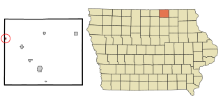
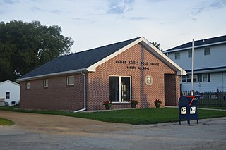
Carpenter is a city in Mitchell County, Iowa, United States. The population was 87 at the 2020 census.

<span class="mw-page-title-main">Blaine, Maine</span> Town in the state of Maine, United States

Blaine is a town in Aroostook County, Maine, United States. The population was 667 at the 2020 census. It was known as Alva prior to incorporation in 1874, when it was renamed in honor of James G. Blaine, then Speaker of the U.S. House of Representatives. According to local history, Blaine offered to donate a large bell for the tower of the town's new meeting hall, if the citizens would rename the town after him. The town's name was changed, but Blaine never donated a bell. The building still stands on the north end of town, on Route 1.

<span class="mw-page-title-main">Amherst, Maine</span> Town in the state of Maine, United States

Amherst is a town in Hancock County, Maine, United States. The population was 248 at the 2020 census.

Frenchboro is a town in Hancock County, Maine, United States, and a village within this town located on Long Island, southeast of Swans Island. The population was 29 at the 2020 census. The town is accessible by state ferry service from Bass Harbor.

<span class="mw-page-title-main">Independence, Minnesota</span> City in Minnesota, United States

Independence is a rural city in Hennepin County, Minnesota, United States. Most of the city is agricultural land with dense woods and numerous lakes. It is named after Lake Independence, a large lake on the community's eastern boundary.

<span class="mw-page-title-main">Stratford, New Hampshire</span> Town in New Hampshire, United States

Stratford is a town located on the Connecticut River in Coös County, New Hampshire, United States. The population was 662 at the 2020 census, a decline from the figure of 746 tabulated in 2010. Within the town are the villages of North Stratford, Stratford Hollow, and Beatties. U.S. Route 3 passes through the center of town, as does the St. Lawrence and Atlantic Railroad, formerly a part of the Grand Trunk Railway.

<span class="mw-page-title-main">Mariaville Lake, New York</span> Census-designated place in New York, United States

Mariaville Lake is a census-designated place (CDP) in Schenectady County, New York. The population was 722 at the 2010 census.

Orange is a town in Schuyler County, New York, United States. The population was 1,408 at the 2020 census.

<span class="mw-page-title-main">Plain Grove Township, Pennsylvania</span> Township in Pennsylvania, United States

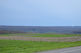
Plain Grove Township is a township in Lawrence County, Pennsylvania, United States. The population was 777 at the time of the 2020 census, a decline from the figure of 813 tabulated in 2010.

<span class="mw-page-title-main">Pulaski Township, Lawrence County, Pennsylvania</span> Township in Pennsylvania, United States

Pulaski Township is a township in Lawrence County, Pennsylvania, United States. The population was 3,096 at the 2020 census, a decline from the figure of 3,452 tabulated in 2010.

<span class="mw-page-title-main">New Philadelphia, Pennsylvania</span> Borough in Pennsylvania, United States

New Philadelphia, also known as New Philly, is a borough in Schuylkill County, Pennsylvania, United States. The population was 1,060 at the 2020 census.

<span class="mw-page-title-main">Hobart, Washington</span> Census-designated place in Washington, United States

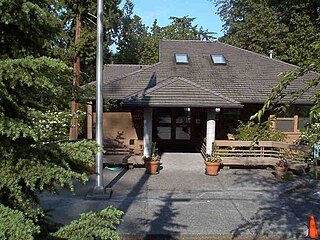
Hobart is an unincorporated community and census-designated place (CDP) in King County, Washington, United States. The population was 6,767 at the 2020 census.

<span class="mw-page-title-main">Yarrow Point, Washington</span> Town in Washington, United States

Yarrow Point is a town in King County, Washington, United States. The population was 1,134 at the 2020 census.

<span class="mw-page-title-main">Pea Ridge, West Virginia</span> Census-designated place in West Virginia, United States

Pea Ridge is a census-designated place in Cabell County, West Virginia, United States. As of the 2020 census, the population was 6,602. It is part of the Huntington–Ashland metropolitan area.

<span class="mw-page-title-main">Weyerhaeuser, Wisconsin</span> Village in Wisconsin, United States

Weyerhaeuser is a village in Rusk County, Wisconsin, United States. The population was 238 at the 2010 census.

References

  1. 1 2 "US Gazetteer files 2010". United States Census Bureau . Retrieved December 16, 2012.
  2. "Census - Geography Profile: Mariaville town, Hancock County, Maine" . Retrieved January 30, 2022.
  3. Chadbourne, Ava H. (May 12, 1951). "Six Maine towns bear women's names". Lewiston Evening Journal. pp. 7A. Retrieved October 18, 2015.
  4. Gannett, Henry (1905). The Origin of Certain Place Names in the United States. U.S. Government Printing Office. p.  199.
  5. "Census of Population and Housing". Census.gov. Retrieved June 4, 2015.
  6. "U.S. Census website". United States Census Bureau . Retrieved December 16, 2012.
  7. "U.S. Census website". United States Census Bureau . Retrieved January 31, 2008.
  8. "Bureau of Corporations, Elections & Commissions, Elections and Voting, Results, 2014 Tabulations".
  9. "Bureau of Corporations, Elections & Commissions, Elections and Voting, Results, 2012 US President Tabulations".
  10. "Bureau of Corporations, Elections & Commissions, Elections and Voting, Results, 2008-09 Tabulations".
  11. "1984 General Election: Presidential". digitalmaine.com.
  12. "1980 General Election: Presidential". digitalmaine.com.
  13. "1976 General Election: Presidential". digitalmaine.com.
  14. "1972 General Election: Presidential". digitalmaine.com.
  15. "1968 General Election: Presidential". digitalmaine.com.
  16. "1964 General Election: Presidential". digitalmaine.com.
  17. "1960 General Election: Presidential". digitalmaine.com.
  18. "1956 General Election: Presidential". digitalmaine.com.
  19. "1952 General Election: Presidential". digitalmaine.com.
  20. "1948 General Election: Presidential". digitalmaine.com.
  21. "1944 General Election: Presidential". digitalmaine.com.
  22. "1940 General Election: Presidential". digitalmaine.com.
  23. "1936 General Election: Presidential". digitalmaine.com.
  24. "1932 General Election: Presidential". digitalmaine.com.
  25. "1928 General Election: Presidential". digitalmaine.com.
  26. "1924 General Election: Presidential". digitalmaine.com.
  27. "1920 General Election: Presidential Electors". digitalmaine.com.
  28. "1916 General Election: Presidential Electors". digitalmaine.com.

44°43′14″N68°24′56″W / 44.72056°N 68.41556°W / 44.72056; -68.41556