
Bass Harbor is a village in Hancock County, Maine, United States. It is within the town of Tremont on Mount Desert Island, and near Acadia National Park. With its well-protected natural harbor, it ranks as one of the most lucrative lobster-producing ports in the state. Bass Harbor Head Lighthouse lies at the mouth of the harbor. The village is also the departure point for Maine State Ferry Service transport to Swans Island and Frenchboro.

Northeast Harbor is a village on Mount Desert Island, located in the town of Mount Desert in Hancock County, Maine, United States.
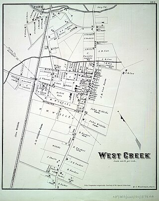
West Creek is an unincorporated community and hamlet located within Eagleswood Township in Ocean County, New Jersey, United States.

Cape Porpoise, Maine is a small coastal village in the town of Kennebunkport, Maine, United States, and was the original English settlement of the town. It is northeast of Dock Square and southwest of Goose Rocks Beach. The village occupies the mainland adjacent to Cape Porpoise Harbor. More than a dozen islands protect the deep natural harbor. The ZIP Code for Cape Porpoise is 04014.
Minturn is a small village on the south side of Swan's Island, a part of Hancock County, Maine, United States. Its approximate latitude and longitude are 44°8’ N, 68°27’ W. The decline of fishing in general and of the local population has caused the village to dwindle. Its post office was consolidated with the Swans Island post office.

Prospect Harbor Point Light is a lighthouse on Prospect Harbor Point, which divides Sand Cove from Inner Harbor at the head of Prospect Harbor on the southern shore of Gouldsboro, Maine. Also known as Prospect Harbor Light, it was first established in 1850. The present structure was built in 1891. It was listed on the National Register of Historic Places as Prospect Harbor Light Station in 1988.

Cologne is an unincorporated community located within Galloway Township, in Atlantic County, New Jersey, United States. Cologne is located on U.S. Route 30, about 2.5 miles (4.0 km) southeast of Egg Harbor City. Cologne has a post office with ZIP code 08213.

Boothbay Harbor is a town in Lincoln County, Maine, United States. The population was 2,027 at the 2020 census. It includes the villages of Bayville, Sprucewold, and West Boothbay Harbor. During summer months, the entire Boothbay Harbor region is a popular yachting and tourist destination. The ZIP Code is 04538, and the community is served by the 633 telephone exchange in area code 207.
Sinclair is an unincorporated village within Square Lake unorganized territory in Aroostook County, Maine, United States. The community is located on Maine State Route 162 and the western shore of Long Lake in the northeastern part of the county, within the unorganized territory of Square Lake. Sinclair has a post office, with ZIP code 04779.
Portage is an unincorporated village within the town of Portage Lake in Aroostook County, Maine, United States. The community is located on Maine State Route 11 and the southeastern shore of Portage Lake, 10 miles (16 km) north-northwest of Ashland. Portage has a post office, with ZIP code 04768, which opened on November 6, 1883.
Fort Kent Mills is an unincorporated village in the town of Fort Kent, Aroostook County, Maine, United States. The community is located on Maine State Route 11 and the Fish River, south of the village of Fort Kent. Fort Kent Mills has a post office, with ZIP code 04744, which opened on April 11, 1906.
East Newport is an unincorporated village in the town of Newport, Penobscot County, Maine, United States. The community is located at the junction of U.S. Route 2, Maine State Route 7, and Maine State Route 100 3.2 miles (5.1 km) east-southeast of the community of Newport. East Newport has a post office with ZIP code 04933.

East Parsonsfield is an unincorporated village in the town of Parsonsfield, York County, Maine, United States. The community is located along Maine State Route 160 near the town's eastern border with Cornish. East Parsonsfield has a post office with ZIP code 04028.

East Waterboro is an unincorporated village in the town of Waterboro, York County, Maine, United States. The community is located at the junction of U.S. Route 202, Maine State Route 4, and Maine State Route 5. East Waterboro has a post office with ZIP code 04030.

Sebago Lake is an unincorporated village in the town of Standish, Cumberland County, Maine, United States. The community is located on the south shore of its eponymous lake at the junction of Maine State Route 35 and Maine State Route 114. Sebago Lake has a post office with ZIP code 04075.
East Dixfield is an unincorporated village in the towns of Wilton in Franklin County and Dixfield in Oxford County, in the U.S. state of Maine. The community is located along U.S. Route 2 and Maine State Route 17 10 miles (16 km) southwest of Farmington. East Dixfield has a post office with ZIP code 04227.
Lambert Lake is a village in unincorporated Lambert Lake Township, Washington County, Maine, United States. The community is located along Maine State Route 6, 27.5 miles (44.3 km) north-northwest of Calais. Lambert Lake had a post office until October 24, 1987; it still has its own ZIP code, 04454. The Eastern Maine Railway passes through the village of Lambert Lake.
West Boothbay Harbor is an unincorporated village in the town of Boothbay Harbor, Lincoln County, Maine, United States. The community is located along Maine State Route 27 10.7 miles (17.2 km) south of Wiscasset. West Boothbay Harbor has a post office with ZIP code 04575.
Birch Harbor is an unincorporated village in the town of Gouldsboro, Hancock County, Maine, United States. The community is located along Maine State Route 186, 22 miles (35 km) east-southeast of Ellsworth. Birch Harbor has a post office with ZIP code 04613, which opened on March 26, 1880.
Salsbury Cove is an unincorporated village in the town of Bar Harbor, Hancock County, Maine, United States. The community is located along Maine State Route 3, 10.3 miles (16.6 km) southeast of Ellsworth. Salsbury Cove has a post office with ZIP code 04672.


