Trenton, Maine

Last updated

Trenton, Maine
Trenton, ME Lighthouse (business) IMG 2442.JPG
The Trenton Lighthouse is not a lighthouse but a business building, now containing a restaurant, The Beacon.
USA Maine location map.svg
Red pog.svg
Trenton
Usa edcp location map.svg
Red pog.svg
Trenton
Coordinates: 44°26′13″N68°23′31″W / 44.43694°N 68.39194°W / 44.43694; -68.39194
Country United States
State Maine
County Hancock
VillagesTrenton
Bayside
West Trenton
Area
[1]
  Total28.39 sq mi (73.53 km2)
  Land18.17 sq mi (47.06 km2)
  Water10.22 sq mi (26.47 km2)
Elevation
49 ft (15 m)
Population
 (2020)
  Total1,584
  Density87/sq mi (33.7/km2)
Time zone UTC-5 (Eastern (EST))
  Summer (DST) UTC-4 (EDT)
ZIP code
04605
Area code 207
FIPS code 23-77415
GNIS feature ID0582768

Trenton is a town in Hancock County, Maine, United States, near Acadia National Park. The population was 1,584 at the 2020 census. [2] Hancock County-Bar Harbor Airport is located in Trenton.

Contents

In January 1969, town voters defeated 144–77 an attempt to build a nuclear power plant and aluminum refinery in Trenton. [3]

Geography

According to the United States Census Bureau, the town has a total area of 28.39 square miles (73.53 km2), of which 18.17 square miles (47.06 km2) is land and 10.22 square miles (26.47 km2) is water. [1]

Demographics

Historical population
CensusPop.Note
1790 312
1800 294−5.8%
1810 50170.4%
1820 63927.5%
1830 79424.3%
1840 1,06233.8%
1850 1,20513.5%
1860 1,40016.2%
1870 678−51.6%
1880 639−5.8%
1890 528−17.4%
1900 459−13.1%
1910 354−22.9%
1920 314−11.3%
1930 3387.6%
1940 40319.2%
1950 358−11.2%
1960 3754.7%
1970 3924.5%
1980 71883.2%
1990 1,06047.6%
2000 1,37029.2%
2010 1,4818.1%
2020 1,5847.0%
U.S. Decennial Census [4]

2010 census

As of the census [5] of 2010, there were 1,481 people, 663 households, and 409 families living in the town. The population density was 81.5 inhabitants per square mile (31.5/km2). There were 1,021 housing units at an average density of 56.2 per square mile (21.7/km2). The racial makeup of the town was 95.3% White, 0.4% African American, 1.6% Native American, 0.4% Asian, 0.2% from other races, and 2.1% from two or more races. Hispanic or Latino of any race were 1.5% of the population.

There were 663 households, of which 23.7% had children under the age of 18 living with them, 46.8% were married couples living together, 8.3% had a female householder with no husband present, 6.6% had a male householder with no wife present, and 38.3% were non-families. 27.9% of all households were made up of individuals, and 8.3% had someone living alone who was 65 years of age or older. The average household size was 2.23 and the average family size was 2.72.

The median age in the town was 45.8 years. 17.4% of residents were under the age of 18; 7.4% were between the ages of 18 and 24; 24% were from 25 to 44; 36% were from 45 to 64; and 15.1% were 65 years of age or older. The gender makeup of the town was 50.6% male and 49.4% female.

2000 census

As of the census [6] of 2000, there were 1,370 people, 574 households, and 388 families living in the town. The population density was 75.3 inhabitants per square mile (29.1/km2). There were 816 housing units at an average density of 44.9 per square mile (17.3/km2). The racial makeup of the town was 95.69% White, 0.58% African American, 1.46% Native American, 0.22% Asian, 0.07% Pacific Islander, 0.07% from other races, and 1.90% from two or more races. Hispanic or Latino of any race were 0.44% of the population.

There were 574 households, out of which 31.9% had children under the age of 18 living with them, 53.8% were married couples living together, 8.9% had a female householder with no husband present, and 32.4% were non-families. 27.0% of all households were made up of individuals, and 8.4% had someone living alone who was 65 years of age or older. The average household size was 2.39 and the average family size was 2.89.

In the town, the population was spread out, with 24.5% under the age of 18, 6.0% from 18 to 24, 27.0% from 25 to 44, 27.7% from 45 to 64, and 14.7% who were 65 years of age or older. The median age was 41 years. For every 100 females, there were 96.0 males. For every 100 females age 18 and over, there were 90.1 males.

The median income for a household in the town was $34,808, and the median income for a family was $45,859. Males had a median income of $30,847 versus $25,197 for females. The per capita income for the town was $21,140. About 6.2% of families and 10.0% of the population were below the poverty line, including 11.5% of those under age 18 and 8.5% of those age 65 or over.

Economy

The Country Store in Trenton photographed by John Margolies, who catalogued architectural sights and roadside attractions across the U.S. (1995) The Country Store, Trenton, Maine LCCN2017706448.tif
The Country Store in Trenton photographed by John Margolies, who catalogued architectural sights and roadside attractions across the U.S. (1995)

Bar Harbor Airlines, a regional airline, was headquartered in Trenton. In 1989 the airline headquarters moved to Houston, Texas. [7] [8]

Related Research Articles

<span class="mw-page-title-main">Hancock County, Maine</span> County in Maine, United States

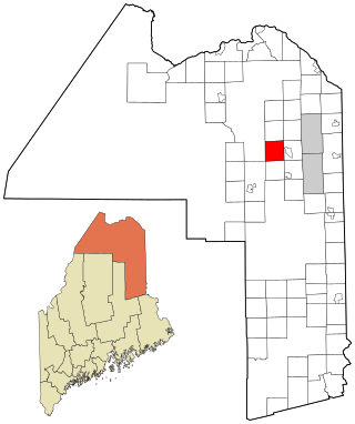
Hancock County is a county located in the U.S. state of Maine. As of the 2020 census, the population was 55,478. Its county seat is Ellsworth. The county was incorporated on June 25, 1789, and named for John Hancock, the first governor of the Commonwealth of Massachusetts.

<span class="mw-page-title-main">Perham, Maine</span> Town in the state of Maine, United States

Perham is a town in Aroostook County, Maine, United States. The population was 371 at the 2020 census. The town was named after Maine's 33rd governor, Sidney Perham.

<span class="mw-page-title-main">Wade, Maine</span> Town in the state of Maine, United States

Wade is a town in Aroostook County, Maine, United States. The population was 229 at the 2020 census.

Aurora is a town in Hancock County, Maine, United States. The town was named for the goddess of dawn. The population was 93 at the 2020 census.

<span class="mw-page-title-main">Franklin, Maine</span> Town in the state of Maine, United States

Franklin is a town in Hancock County, Maine, United States. The population was 1,567 at the 2020 census. The town's namesake is Benjamin Franklin.

Great Pond is a town in Hancock County, Maine, United States. The population was 61 at the 2020 census.

<span class="mw-page-title-main">Hancock, Maine</span> Town in the state of Maine, United States

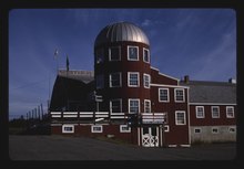
Hancock is a town in Hancock County, Maine, United States. The population was 2,466 at the 2020 census. Located on the mainland at the head of Frenchman Bay, Hancock has commanding views of Mount Desert Island.

<span class="mw-page-title-main">Mount Desert, Maine</span> Town in the state of Maine, United States

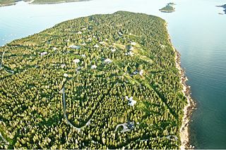
Mount Desert is a town on Mount Desert Island in Hancock County, Maine, United States. The population was 2,146 at the 2020 census. Incorporated in 1789, the town currently encompasses the villages of Otter Creek, Seal Harbor, Northeast Harbor, Somesville, Hall Quarry, and Pretty Marsh.

Orland is a town in Hancock County, Maine, United States. The population was 2,221 at the 2020 census.

Osborn is a town in Hancock County, Maine, United States. The population was 65 at the 2020 census.

Otis is a town in Hancock County, Maine, United States. The population was 673 at the 2020 census.

<span class="mw-page-title-main">Penobscot, Maine</span> Town in the state of Maine, United States

Penobscot is a town in Hancock County, Maine, United States. The Bagaduce River flows through the town. The population was 1,136 at the 2020 census.

<span class="mw-page-title-main">Sorrento, Maine</span> Town in Maine, United States

Sorrento is a town in Hancock County, Maine, United States. The population was 279 at the 2020 census.

<span class="mw-page-title-main">Verona Island, Maine</span> Town in Maine, United States

Verona Island is a town located on an island of the same name in the Penobscot River in Hancock County, Maine, United States. The population was 507 at the 2020 census.

Waltham is a town in Hancock County, Maine, United States. The population was 332 at the 2020 census.

<span class="mw-page-title-main">Winter Harbor, Maine</span> Town in the state of Maine, United States

Winter Harbor is a town on the Schoodic Peninsula in Hancock County, Maine, United States. The population was 461 at the 2020 census. The town is located just outside the Schoodic Peninsula portion of Acadia National Park and is due east of the town of Bar Harbor and Ellsworth. Winter Harbor was once the location of a US Naval Station, NSGA-WH, which closed in the mid-2000s, and is now home to the Schoodic Institute’s Education and Research Center.

<span class="mw-page-title-main">Sidney, Maine</span> Town in the state of Maine, United States

Sidney is a town in Kennebec County, Maine, United States. The population was 4,645 at the 2020 census. Sidney was incorporated as a town on January 30, 1792. The town was named for Sir Philip Sidney, an English author. Sidney is included in the Augusta, Maine micropolitan New England City and Town Area. Since 1937, the town has been the home of the New England Music Camp.

<span class="mw-page-title-main">Peru, Maine</span> Town in Maine, US

Peru is a town in Oxford County, Maine, United States. Peru is included in the Lewiston-Auburn, Maine metropolitan New England city and town area. The population was 1,488 at the 2020 census.

Kenduskeag is a town in Penobscot County, Maine, United States. The population was 1,346 at the 2020 census.

<span class="mw-page-title-main">St. Albans, Maine</span> Town in the state of Maine, United States

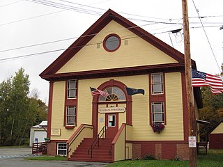
St. Albans is a town in Somerset County, Maine, United States. The population was 2,045 at the 2020 census.

References

  1. 1 2 "US Gazetteer files 2010". United States Census Bureau . Retrieved December 16, 2012.
  2. "Census - Geography Profile: Trenton town, Hancock County, Maine" . Retrieved January 20, 2022.
  3. Cole, John N. (January 24, 1969). "The voters of Trenton, the men of TEPCO, and Maine". Maine Times. and Cole, John N. (January 31, 1969). "Happy beginning". Maine Times., reprinted in The Best of Maine Times. Bangor, Maine: Maine Times Publishing Company. 2003. pp. 27–29, 35. ISBN   0-9729124-1-X.
  4. "Census of Population and Housing". Census.gov. Retrieved June 4, 2015.
  5. "U.S. Census website". United States Census Bureau . Retrieved December 16, 2012.
  6. "U.S. Census website". United States Census Bureau . Retrieved January 31, 2008.
  7. World Airline Directory. Flight International. February 14, 1974. "204.
  8. "Bar Harbor Airways is Moving Its Headquarters to Houston". Boston Globe Archives. Associated Press. October 18, 1989. Archived from the original on July 12, 2012. Retrieved September 30, 2009.

44°26′20″N68°22′12″W / 44.43889°N 68.37000°W / 44.43889; -68.37000