Otis, Maine

Last updated

Otis, Maine
USA Maine location map.svg
Red pog.svg
Otis, Maine
Location within the state of Maine
Coordinates: 44°42′9″N68°27′51″W / 44.70250°N 68.46417°W / 44.70250; -68.46417
Country United States
State Maine
County Hancock
Area
[1]
  Total28.58 sq mi (74.02 km2)
  Land24.77 sq mi (64.15 km2)
  Water3.81 sq mi (9.87 km2)
Elevation
243 ft (74 m)
Population
 (2020)
  Total673
  Density27/sq mi (10.5/km2)
Time zone UTC-5 (Eastern (EST))
  Summer (DST) UTC-4 (EDT)
ZIP code
04605
Area code 207
FIPS code 23-55890
GNIS feature ID0582654

Otis is a town in Hancock County, Maine, United States. The population was 673 at the 2020 census. [2]

Contents

Geography

According to the United States Census Bureau, the town has a total area of 28.58 square miles (74.02 km2), of which 24.77 square miles (64.15 km2) is land and 3.81 square miles (9.87 km2) is water. [1]

Demographics

Historical population
CensusPop.Note
1830 350
1840 88−74.9%
1850 12440.9%
1860 21069.4%
1870 24617.1%
1880 30423.6%
1890 239−21.4%
1900 152−36.4%
1910 115−24.3%
1920 1226.1%
1930 88−27.9%
1940 13452.3%
1950 109−18.7%
1960 100−8.3%
1970 12323.0%
1980 307149.6%
1990 35515.6%
2000 54353.0%
2010 67223.8%
2020 6730.1%
U.S. Decennial Census [3]

2010 census

As of the census [4] of 2010, there were 672 people, 299 households, and 197 families living in the town. The population density was 27.1 inhabitants per square mile (10.5/km2). There were 744 housing units at an average density of 30.0 per square mile (11.6/km2). The racial makeup of the town was 97.9% White, 0.4% African American, 0.3% Native American, 0.1% Asian, 0.1% from other races, and 1.0% from two or more races. Hispanic or Latino of any race were 0.6% of the population.

There were 299 households, of which 24.1% had children under the age of 18 living with them, 55.9% were married couples living together, 7.0% had a female householder with no husband present, 3.0% had a male householder with no wife present, and 34.1% were non-families. 26.4% of all households were made up of individuals, and 8.6% had someone living alone who was 65 years of age or older. The average household size was 2.25 and the average family size was 2.72.

The median age in the town was 47.1 years. 18.7% of residents were under the age of 18; 5% were between the ages of 18 and 24; 22% were from 25 to 44; 39.1% were from 45 to 64; and 15.3% were 65 years of age or older. The gender makeup of the town was 50.7% male and 49.3% female.

2000 census

As of the census [5] of 2000, there were 543 people, 229 households, and 160 families living in the town. The population density was 21.8 people per square mile (8.4/km2). There were 678 housing units at an average density of 27.2 per square mile (10.5/km2). The racial makeup of the town was 98.90% White, 0.37% Native American, and 0.74% from two or more races. Hispanic or Latino of any race were 0.18% of the population.

There were 229 households, out of which 28.4% had children under the age of 18 living with them, 59.4% were married couples living together, 7.4% had a female householder with no husband present, and 29.7% were non-families. 25.8% of all households were made up of individuals, and 8.7% had someone living alone who was 65 years of age or older. The average household size was 2.37 and the average family size was 2.81.

In the town, the population was spread out, with 23.0% under the age of 18, 6.3% from 18 to 24, 29.7% from 25 to 44, 30.0% from 45 to 64, and 11.0% who were 65 years of age or older. The median age was 41 years. For every 100 females, there were 114.6 males. For every 100 females age 18 and over, there were 103.9 males.

The median income for a household in the town was $36,250, and the median income for a family was $47,917. Males had a median income of $36,979 versus $22,500 for females. The per capita income for the town was $20,375. About 8.4% of families and 9.5% of the population were below the poverty line, including 10.3% of those under age 18 and 14.5% of those age 65 or over.

See also

Related Research Articles

<span class="mw-page-title-main">Fillmore, Indiana</span> Town in Indiana, United States

Fillmore is a town in Marion Township, Putnam County, in the U.S. state of Indiana. The population was 532 at the 2020 census.

<span class="mw-page-title-main">Hammond, Maine</span> Town in the state of Maine, United States

Hammond is a town in Aroostook County, Maine, United States. The population was 91 at the 2020 census.

<span class="mw-page-title-main">Stockholm, Maine</span> Town in the state of Maine, United States

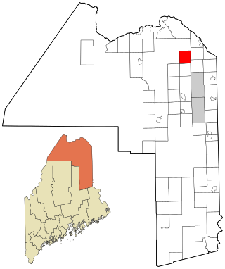
Stockholm is a town in Aroostook County, Maine, United States. The population was 250 at the 2020 census.

<span class="mw-page-title-main">Westfield, Maine</span> Town in the state of Maine, United States

Westfield is a town in Aroostook County, Maine, United States. The population was 455 at the 2020 census.

<span class="mw-page-title-main">Chesterville, Maine</span> Town in Maine, United States

Chesterville is a town in Franklin County, Maine, United States. The population was 1,328 at the 2020 census.

<span class="mw-page-title-main">Vienna, Maine</span> Town in the state of Maine, United States

Vienna is a town in Kennebec County, Maine, United States. The population was 578 at the 2020 census.

<span class="mw-page-title-main">West Gardiner, Maine</span> Town in the state of Maine, United States

West Gardiner is a town in Kennebec County, Maine, United States. The population was 3,671 at the 2020 census. West Gardiner is included in the Augusta, Maine micropolitan New England City and Town Area.

<span class="mw-page-title-main">Hartford, Maine</span> Town in the state of Maine, United States

Hartford is a town in Oxford County, Maine, United States. Hartford is included in the Lewiston-Auburn, Maine metropolitan New England City and Town Area. The population was 1,203 at the 2020 census.

<span class="mw-page-title-main">Upton, Maine</span> Town in the state of Maine, United States

Upton is a town in Oxford County, Maine, United States. The population was 69 at the 2020 census.

Detroit is a town in Somerset County, Maine, United States. The population was 885 at the 2020 census.

Ripley is a town in Somerset County, Maine, United States. The community was named after Brigadier General Eleazer Wheelock Ripley of the War of 1812. The population was 484 at the 2020 census.

<span class="mw-page-title-main">Burnham, Maine</span> Town in the state of Maine, United States

Burnham is a town in Waldo County, Maine, United States. The population was 1,096 at the 2020 census.

Deblois is a town in Washington County, Maine, United States. The town was named after T.A. Deblois, president of the Bank of Portland. The population was 74 at the 2020 census.

<span class="mw-page-title-main">Urbank, Minnesota</span> City in Minnesota, United States

Urbank is a city in Otter Tail County, Minnesota, United States. The population was 52 at the 2020 census.

<span class="mw-page-title-main">Edgeley, North Dakota</span> City in North Dakota, United States

Edgeley is a city in LaMoure County, North Dakota, United States. The population was 585 at the 2020 census.

<span class="mw-page-title-main">Addyston, Ohio</span> Village in Ohio, United States

Addyston is a village in Miami Township, Hamilton County, Ohio, United States. Located along the Ohio River, it is a western suburb of the neighboring city of Cincinnati. The population was 927 at the 2020 census.

<span class="mw-page-title-main">Markleysburg, Pennsylvania</span> Borough in Pennsylvania, United States

Markleysburg is a borough in Fayette County, Pennsylvania, United States. The population was 246 at the 2020 census. The borough is served by the Uniontown Area School District.

<span class="mw-page-title-main">Bay City, Wisconsin</span> Village in Wisconsin, United States

Bay City is a village on the Mississippi River in Pierce County, Wisconsin, United States. The population was 500 at the 2010 census.

<span class="mw-page-title-main">Theresa, Wisconsin</span> Village in Wisconsin, United States

Theresa is a village in Dodge County, Wisconsin, United States. The population was 1,262 at the 2010 census. The village is within the Town of Theresa.

<span class="mw-page-title-main">Dixfield (CDP), Maine</span> CDP in Maine, United States

Dixfield is a census-designated place (CDP) in the town of Dixfield in Oxford County, Maine, United States. The population was 1,323 at the 2020 census.

References

  1. 1 2 "US Gazetteer files 2010". United States Census Bureau . Retrieved December 16, 2012.
  2. "Census - Geography Profile: Otis town, Hancock County, Maine" . Retrieved January 23, 2022.
  3. "Census of Population and Housing". Census.gov. Retrieved June 4, 2015.
  4. "U.S. Census website". United States Census Bureau . Retrieved December 16, 2012.
  5. "U.S. Census website". United States Census Bureau . Retrieved January 31, 2008.

44°42′44″N68°27′10″W / 44.71222°N 68.45278°W / 44.71222; -68.45278