Smyrna, Maine

Last updated

Smyrna, Maine
Aroostook County Maine incorporated and unincorporated areas Smyrna highlighted.svg
Location of Smyrna, Maine
Coordinates: 46°8′10″N68°5′51″W / 46.13611°N 68.09750°W / 46.13611; -68.09750
Country Flag of the United States (23px).png  United States
State Flag of Maine.svg Maine
County Aroostook
VillagesSmyrna Center
Smyrna Mills
Area
[1]
  Total35.20 sq mi (91.17 km2)
  Land35.11 sq mi (90.93 km2)
  Water0.09 sq mi (0.23 km2)
Elevation
968 ft (295 m)
Population
 (2020)
  Total439
  Density12/sq mi (4.8/km2)
Time zone UTC-5 (Eastern (EST))
  Summer (DST) UTC-4 (EDT)
Area code 207
FIPS code 23-69260
GNIS feature ID0582727
Website smyrna.aroostook.me.us

Smyrna is a town in Aroostook County, Maine, United States. The population was 439 at the 2020 census. [2]

Contents

Geography

According to the United States Census Bureau, the town has a total area of 35.20 square miles (91.17 km2), of which 35.11 square miles (90.93 km2) is land and 0.09 square miles (0.23 km2) is water. [1]

Demographics

Historical population
CensusPop.Note
1840 184
1850 172−6.5%
1860 165−4.1%
1870 159−3.6%
1880 23749.1%
1890 30327.8%
1900 41135.6%
1910 4110.0%
1920 46011.9%
1930 442−3.9%
1940 409−7.5%
1950 349−14.7%
1960 331−5.2%
1970 318−3.9%
1980 35411.3%
1990 3786.8%
2000 4159.8%
2010 4426.5%
2020 439−0.7%
U.S. Decennial Census [3]

2010 census

At the 2010 census there were 442 people, 155 households, and 108 families living in the town. The population density was 12.6 inhabitants per square mile (4.9/km2). There were 188 housing units at an average density of 5.4 per square mile (2.1/km2). The racial makeup of the town was 98.2% White, 1.1% Native American, 0.2% Asian, and 0.5% from two or more races. Hispanic or Latino of any race were 0.2%. [4]

Of the 155 households 36.1% had children under the age of 18 living with them, 58.7% were married couples living together, 5.2% had a female householder with no husband present, 5.8% had a male householder with no wife present, and 30.3% were non-families. 22.6% of households were one person and 8.4% were one person aged 65 or older. The average household size was 2.85 and the average family size was 3.40.

The median age in the town was 36.8 years. 29.2% of residents were under the age of 18; 6% were between the ages of 18 and 24; 23.8% were from 25 to 44; 30.6% were from 45 to 64; and 10.4% were 65 or older. The gender makeup of the town was 49.3% male and 50.7% female.

2000 census

At the 2000 census there were 415 people, 155 households, and 110 families living in the town. The population density was 11.8 people per square mile (4.6/km2). There were 184 housing units at an average density of 5.2 per square mile (2.0/km2). The racial makeup of the town was 99.28% White, 0.24% Native American, 0.24% Asian, and 0.24% from two or more races. [5] Of the 155 households 33.5% had children under the age of 18 living with them, 60.6% were married couples living together, 7.1% had a female householder with no husband present, and 29.0% were non-families. 25.8% of households were one person and 14.2% were one person aged 65 or older. The average household size was 2.68 and the average family size was 3.25.

The age distribution was 27.0% under the age of 18, 8.9% from 18 to 24, 28.7% from 25 to 44, 20.5% from 45 to 64, and 14.9% 65 or older. The median age was 37 years. For every 100 females, there were 93.9 males. For every 100 females age 18 and over, there were 89.4 males.

The median household income was $25,625 and the median family income was $27,917. Males had a median income of $23,625 versus $20,313 for females. The per capita income for the town was $11,751. About 16.4% of families and 20.3% of the population were below the poverty line, including 24.1% of those under age 18 and 26.7% of those age 65 or over.

Amish community

There is an Amish community in Smyrna, that began as one of the "Christian Communities" of Elmo Stoll in 1996. From the beginning most members had an Amish background, but some came from other plain communities while others had no plain background. Soon after the early death of Elmo Stoll in 1998, the "Christian Communities" began to disband. The community in Smyrna lost most of his members, who had no plain background, and then decided to seek fellowship with the Michigan Amish Churches of the Old Order Amish. The Amish in Smyrna are said to be more open to outsiders than other Amish communities. They hold most of their church services in English. [6] They are in fellowship with the Maine Amish in Unity and Hodgdon. [7] Contrary to most other Amish, the Amish men in Smyrna wear moustaches along with long beards, which reflects their "Christian Communities" history. [8] In 2005, the Amish community consisted of approximately 100 people. [9]

Related Research Articles

<span class="mw-page-title-main">Ashland, Maine</span> Town in Maine, United States

Ashland is a town in Aroostook County, Maine, United States. The population was 1,202 at the 2020 census.

<span class="mw-page-title-main">Dyer Brook, Maine</span> Town in the state of Maine, United States

Dyer Brook is a town in Aroostook County, Maine, United States. The population was 215 at the 2020 census. Dyer Brook is also host to the local school, Southern Aroostook Community School.

<span class="mw-page-title-main">Eagle Lake, Maine</span> Town in the state of Maine, United States

Eagle Lake is a town in Aroostook County, Maine, United States. The population was 772 at the 2020 census. The town was named by a body of troops heading from Bangor to the Aroostook War for the many eagles that they saw around the lake. A total of 49.0% of the population speaks French, reflecting a trend in Northeastern Maine.

<span class="mw-page-title-main">Frenchville, Maine</span> Town in the state of Maine, United States

Frenchville is a town in Aroostook County, Maine, United States. The population was 1,052 at the 2020 census.

<span class="mw-page-title-main">Garfield Plantation, Maine</span> Plantation in Maine, United States

Garfield Plantation is a plantation in Aroostook County, Maine, United States. The population was 79 at the 2020 census.

<span class="mw-page-title-main">Grand Isle, Maine</span> Town in the state of Maine, United States

Grand Isle is a town in Aroostook County, Maine, United States. The population was 366 at the 2020 census. The village of Grand Isle is in the northwestern part of the town.

<span class="mw-page-title-main">Haynesville, Maine</span> Town in the state of Maine, United States

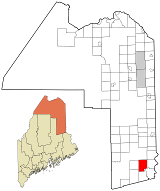
Haynesville is a town in Aroostook County, Maine, United States. The population was 97 at the 2020 census.

<span class="mw-page-title-main">Hodgdon, Maine</span> Town in the state of Maine, United States

Hodgdon is a rural town in Aroostook County, Maine, United States. The town borders the province of New Brunswick, Canada to the east and Houlton to the north. Hodgdon's population was 1,290 at the 2020 census.

<span class="mw-page-title-main">Monticello, Maine</span> Town in the state of Maine, United States

Monticello is a town in Aroostook County, Maine, United States on the northern branch of the Meduxnekeag River. The population was 737 at the 2020 census. Originally known as Wellington Township, it was settled in 1830 by General Joel Wellington, who owned it, and incorporated in 1846. Some of the earlier migrant workers of Monticello were called the “Amerisee”—a currently disbanded tribe whose members consisted of tribal people from all five Wabanaki Maine tribes, who traveled together as migrant seasonal workers. Many of them had settled in the Monticello and other Aroostook County areas. The word “Amerisee” comes from the Mi’kmaq word “Amase’jijg” which means “some distance” or “quite far” in reference to the distance they traveled for work, which often included all areas of Canada and Aroostook County Maine. The Matthew(s) family shows up in the 1900 Census for Monticello Maine. They had intended to form a sixth tribe—one that accepted members from all five tribes who were originally one tribe, but due to colonization, it had been split up into the five groups known today. The Amerisee wished to reunite the five tribes. The attempt ultimately failed and the Amerisee tribal members, were reabsorbed into their tribes of origin. John Matthew, who is listed on the 1900 Census in Monticello Maine along with his family, writes that he is “Amerisee” however under “Tribe of Father of this Indian” and “Tribe of Mother of this Indian” he says they were both “mi’kmaw” which is the Mi’kmaq word for “Mi’kmaq”. His children were listed as Frank, Lizzie and Annie (Anastasia) Matthew. His parents were Frank and Bertha Matthew(s). He was also a basket maker. According to his death record, he was born in “Restigouche Ind.” territory, which is a testament to how far they would travel to reach farmland in places such as Monticello. John Matthew and other families like his, make up an interesting Native American element to Monticello’s migrant seasonal and farm work history. International shortwave broadcast station WBCQ is located here.

<span class="mw-page-title-main">Nashville Plantation, Maine</span> Plantation in Maine, United States

Nashville Plantation is a plantation in Aroostook County, Maine, United States. The population was 27 at the 2020 census.

<span class="mw-page-title-main">New Limerick, Maine</span> Town in the state of Maine, United States

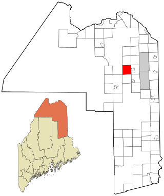
New Limerick is a town in Aroostook County, Maine, United States. The population was 574 at the 2020 census. The town was settled in 1775 and incorporated on March 18, 1837, from New Limerick Plantation. It received its name from the fact that many of its settlers had previously lived in Limerick in York County at the southern end of the state, which in turn was probably named after the Irish city of Limerick.

<span class="mw-page-title-main">Perham, Maine</span> Town in the state of Maine, United States

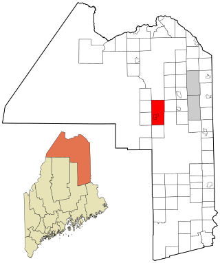
Perham is a town in Aroostook County, Maine, United States. The population was 371 at the 2020 census. The town was named after Maine's 33rd governor, Sidney Perham.

<span class="mw-page-title-main">Portage Lake, Maine</span> Town in the state of Maine, United States

Portage Lake is a town in Aroostook County, Maine, United States. The population was 359 at the 2020 census.

<span class="mw-page-title-main">St. Agatha, Maine</span> Town in the state of Maine, United States

St. Agatha is a town in Aroostook County, Maine, United States. The population was 730 at the 2020 census.

<span class="mw-page-title-main">Stockholm, Maine</span> Town in the state of Maine, United States

Stockholm is a town in Aroostook County, Maine, United States. The population was 250 at the 2020 census.

<span class="mw-page-title-main">Wade, Maine</span> Town in the state of Maine, United States

Wade is a town in Aroostook County, Maine, United States. The population was 229 at the 2020 census.

<span class="mw-page-title-main">Westmanland, Maine</span> Town in the state of Maine, United States

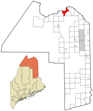
Westmanland is a town in Aroostook County, Maine, United States. The population was 79 at the 2020 census.

<span class="mw-page-title-main">Manton, Michigan</span> City in Michigan, United States

Manton is a city in Wexford County in the U.S. state of Michigan. The population was 1,258 at the 2020 census. The city is located in northeastern Wexford County, which itself is part of Northern Michigan.

<span class="mw-page-title-main">Square Lake, Maine</span> Unorganized territory in Maine, United States

Square Lake is an unorganized territory in Aroostook County, Maine, United States. The population was 706 at the 2020 census.

Unity is a town in Waldo County, Maine, United States. The population was 2,292 at the 2020 census. The town is the service center for the northern portion of Waldo County. Outside of Waldo County, it is best known as the home of the Maine Organic Farmers and Gardeners Association, its Common Ground Country Fair and Unity College. Unity College was founded in 1965 to offset the economic effects of the declining chicken farming industry. As of 2007, the college is the town's largest employer.

References

  1. 1 2 "2010 Census Gazetteer Files". United States Census Bureau. Archived from the original on November 3, 2012.
  2. "Census - Geography Profile: Smyrna town, Aroostook County, Maine" . Retrieved February 27, 2022.
  3. "Census of Population and Housing". Census.gov. Retrieved June 4, 2015.
  4. "U.S. Census website". United States Census Bureau . Retrieved December 16, 2012.
  5. "U.S. Census website". United States Census Bureau . Retrieved January 31, 2008.
  6. "Maine Amish". Amish America. October 24, 2009. Archived from the original on June 28, 2010.
  7. Kevin Williams (April 21, 2015). "Amish Scenes From Smyrna – Part I". Amish365.com. Archived from the original on May 1, 2015.
  8. Kevin Williams (April 23, 2015). "Smyrna, Maine Amish – Part III". Amish365.com. Archived from the original on April 28, 2015.
  9. Sarah Schweitzer (February 2, 2005). "Putting down roots: Amish find a home in rugged Maine". The Boston Globe . Archived from the original on February 9, 2005.