Sherman, Maine

Last updated

Sherman, Maine
Aroostook County Maine incorporated and unincorporated areas Sherman highlighted.svg
Location of Sherman, Maine
Coordinates: 45°53′40″N68°21′32″W / 45.89444°N 68.35889°W / 45.89444; -68.35889
Country United States
State Maine
County Aroostook
VillagesSherman
Sherman Mills
Woodbridge Corner
Area
[1]
  Total40.53 sq mi (104.97 km2)
  Land40.04 sq mi (103.70 km2)
  Water0.49 sq mi (1.27 km2)
Elevation
607 ft (185 m)
Population
 (2020)
  Total815
  Density20/sq mi (7.9/km2)
Time zone UTC-5 (Eastern (EST))
  Summer (DST) UTC-4 (EDT)
Area code 207
FIPS code 23-67790
GNIS feature ID0582723

Sherman is a town in Aroostook County, Maine, United States. The population was 815 at the 2020 census. [2]

Contents

Geography

According to the United States Census Bureau, the town has a total area of 40.53 square miles (104.97 km2), of which 40.04 square miles (103.70 km2) is land and 0.49 square miles (1.27 km2) is water. [1]

Demographics

Historical population
CensusPop.Note
1850 194
1870 701
1880 79813.8%
1890 90913.9%
1900 9807.8%
1910 1,0537.4%
1920 1,1347.7%
1930 1,027−9.4%
1940 1,0583.0%
1950 1,029−2.7%
1960 1,0340.5%
1970 949−8.2%
1980 1,0217.6%
1990 1,0270.6%
2000 937−8.8%
2010 848−9.5%
2020 815−3.9%
U.S. Decennial Census [3]

2010 census

As of the census [4] of 2010, there were 848 people, 363 households, and 247 families living in the town. The population density was 21.2 inhabitants per square mile (8.2/km2). There were 452 housing units at an average density of 11.3 per square mile (4.4/km2). The racial makeup of the town was 97.9% White, 1.2% Native American, and 0.9% from two or more races.

There were 363 households, of which 22.9% had children under the age of 18 living with them, 55.1% were married couples living together, 8.5% had a female householder with no husband present, 4.4% had a male householder with no wife present, and 32.0% were non-families. 26.2% of all households were made up of individuals, and 11.8% had someone living alone who was 65 years of age or older. The average household size was 2.34 and the average family size was 2.77.

The median age in the town was 48.8 years. 19% of residents were under the age of 18; 5% were between the ages of 18 and 24; 21.4% were from 25 to 44; 35.4% were from 45 to 64; and 19.2% were 65 years of age or older. The gender makeup of the town was 50.0% male and 50.0% female.

2000 census

As of the census [5] of 2000, there were 458 people, 374 households, and 289 families living in the town. The population density was 23.2 people per square mile (9.0/km2). There were 449 housing units at an average density of 11.1 per square mile (4.3/km2). The racial makeup of the town was 97.87% White, 0.32% African American, 0.75% Native American, 0.21% from other races, and 0.85% from two or more races. Hispanic or Latino of any race were 0.21% of the population.

There were 374 households, out of which 31.3% had children under the age of 18 living with them, 68.7% were married couples living together, 5.9% had a female householder with no husband present, and 22.5% were non-families. 20.3% of all households were made up of individuals, and 11.2% had someone living alone who was 65 years of age or older. The average household size was 2.51 and the average family size was 2.84.

In the town, the age distribution of the population was: 23.4% under the age of 18, 5.2% from 18 to 24, 25.3% from 25 to 44, 28.9% from 45 to 64, and 17.2% who were 65 years of age or older. The median age was 42 years. For every 100 females, there were 100.6 males. For every 100 females age 18 and over, there were 94.1 males.

The median income for a household in the town was $27,574, and the median income for a family was $32,500. Males had a median income of $34,821 versus $20,694 for females. The per capita income for the town was $14,524. About 11.2% of families and 13.5% of the population were below the poverty line, including 16.3% of those under age 18 and 14.2% of those age 65 or over.

Related Research Articles

<span class="mw-page-title-main">Bancroft, Maine</span> Unorganized territory in Maine, United States

Bancroft is a township in Aroostook County, Maine, United States. The population was 57 at the 2020 census. On July 1, 2015 the town voted to deorganize and become part of the unorganized territory of South Aroostook.

<span class="mw-page-title-main">Crystal, Maine</span> Town in the state of Maine, United States

Crystal is a town in Aroostook County, Maine, United States. The population was 248 at the 2020 census.

<span class="mw-page-title-main">Dyer Brook, Maine</span> Town in the state of Maine, United States

Dyer Brook is a town in Aroostook County, Maine, United States. The population was 215 at the 2020 census. Dyer Brook is also host to the local school, Southern Aroostook Community School.

<span class="mw-page-title-main">Eagle Lake, Maine</span> Town in the state of Maine, United States

Eagle Lake is a town in Aroostook County, Maine, United States. The population was 772 at the 2020 census. The town was named by a body of troops heading from Bangor to the Aroostook War for the many eagles that they saw around the lake. A total of 49.0% of the population speaks French, reflecting a trend in Northeastern Maine.

<span class="mw-page-title-main">Frenchville, Maine</span> Town in the state of Maine, United States

Frenchville is a town in Aroostook County, Maine, United States. The population was 1,052 at the 2020 census.

<span class="mw-page-title-main">Haynesville, Maine</span> Town in the state of Maine, United States

Haynesville is a town in Aroostook County, Maine, United States. The population was 97 at the 2020 census.

<span class="mw-page-title-main">Hersey, Maine</span> Town in the state of Maine, United States

Hersey is a town in Aroostook County, Maine, United States. The population was 73 at the 2020 census.

<span class="mw-page-title-main">Linneus, Maine</span> Town in the state of Maine, United States

Linneus is a town in Aroostook County, Maine, United States. The population was 947 at the 2020 census. It is named after Carl Linnaeus.

<span class="mw-page-title-main">Mapleton, Maine</span> Town in the state of Maine, United States

Mapleton is a town in Aroostook County, Maine, United States. The population was 1,886 at the 2020 census.

<span class="mw-page-title-main">Masardis, Maine</span> Town in Maine, United States

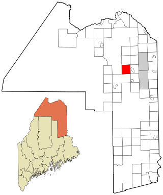
Masardis is a town in Aroostook County, Maine, United States. The population was 204 at the 2020 census.

<span class="mw-page-title-main">Merrill, Maine</span> Town in the state of Maine, United States

Merrill is a town in Aroostook County, Maine, United States. The population was 208 at the 2020 census.

<span class="mw-page-title-main">New Canada, Maine</span> Town in the state of Maine, United States

New Canada is a town in Aroostook County, Maine, United States. The population was 310 at the 2020 census.

<span class="mw-page-title-main">Orient, Maine</span> Town in the state of Maine, United States

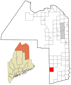
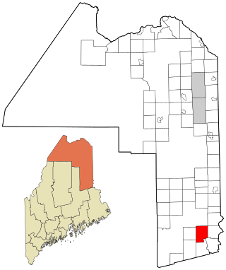
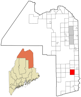
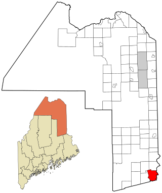
Orient is a town in Aroostook County, Maine, United States. The population was 156 at the 2020 census.

<span class="mw-page-title-main">Perham, Maine</span> Town in the state of Maine, United States

Perham is a town in Aroostook County, Maine, United States. The population was 371 at the 2020 census. The town was named after Maine's 33rd governor, Sidney Perham.

<span class="mw-page-title-main">Portage Lake, Maine</span> Town in the state of Maine, United States

Portage Lake is a town in Aroostook County, Maine, United States. The population was 359 at the 2020 census.

<span class="mw-page-title-main">Stockholm, Maine</span> Town in the state of Maine, United States

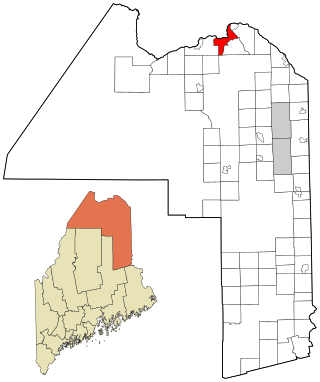
Stockholm is a town in Aroostook County, Maine, United States. The population was 250 at the 2020 census.

<span class="mw-page-title-main">Wade, Maine</span> Town in the state of Maine, United States

Wade is a town in Aroostook County, Maine, United States. The population was 229 at the 2020 census.

<span class="mw-page-title-main">Westfield, Maine</span> Town in the state of Maine, United States

Westfield is a town in Aroostook County, Maine, United States. The population was 455 at the 2020 census.

<span class="mw-page-title-main">Westmanland, Maine</span> Town in the state of Maine, United States

Westmanland is a town in Aroostook County, Maine, United States. The population was 79 at the 2020 census.

<span class="mw-page-title-main">Weston, Maine</span> Town in the state of Maine, United States

Weston is a town in Aroostook County, Maine, United States. The population was 245 at the 2020 census.

References

  1. 1 2 "US Gazetteer files 2010". United States Census Bureau . Retrieved December 16, 2012.
  2. "Census - Geography Profile: Sherman town, Aroostook County, Maine" . Retrieved January 23, 2022.
  3. "Census of Population and Housing". Census.gov. Retrieved June 4, 2015.
  4. "U.S. Census website". United States Census Bureau . Retrieved December 16, 2012.
  5. "U.S. Census website". United States Census Bureau . Retrieved January 31, 2008.

45°52′16″N68°25′04″W / 45.87111°N 68.41778°W / 45.87111; -68.41778