Broadfield is one of 14 neighbourhoods within the town of Crawley in West Sussex, England. Broadfield is located in the south west of the town. It is bordered by Bewbush to the north, Southgate to the north east and Tilgate to the east.
Broadfield is split across three local government wards, Broadfield, Bewbush & North Broadfield and Gossops Green & North East Broadfield.
Broadfield was built in several stages and is relatively densely populated. There is a mixture of property types, including private estates, housing association, council houses and self-build.
Broadfield has one central shopping parade, the Barton, which is one of the largest neighbourhood parade in the town. Unlike many of the parades in the town, which are council run, the Barton is owned and managed by the shop-owners. There is a wide variety of shops, a library, a church (shared by Anglicans, Catholics and Broadfield Christian Fellowship), a nearby mosque and a large medical centre. There is also a community centre which is run as a charitable organisation overseen by trustees from the churches.
There are two infant/primary schools in the neighbourhood, an adventure playground, several open spaces with football pitches, and Broadfield Stadium, home to Crawley Town Football Club. In 2005 a purpose-built Sure Start Children's Centre was opened on Creasys Drive providing support and facilities for families of under 5's. The Broadfield centre works closely with a similar establishment in Bewbush.
Next to the stadium is Broadfield Park which used to be part of the Tilgate Estate. Broadfield House was the hunting lodge for the estate, and the park contains a small lake and some woods.
Crawley is a large town and borough in West Sussex, England. It is 28 miles (45 km) south of London, 18 miles (29 km) north of Brighton and Hove, and 32 miles (51 km) north-east of the county town of Chichester. Crawley covers an area of 17.36 square miles (44.96 km2) and had a population of 106,597 at the time of the 2011 Census.
Pease Pottage is a village in the Mid Sussex District of West Sussex, England. It lies on the southern edge of the Crawley built-up area, in the civil parish of Slaugham.
Southgate is one of the 14 residential neighbourhoods in Crawley, a town and borough in West Sussex, England. Crawley was planned and laid out as a New Town after the Second World War, based on the principle of self-contained neighbourhoods surrounding a town centre of civic and commercial buildings. Southgate was one of the four in the "inner ring" closest to the town centre, and was intended to be the largest of the nine designed in the original master plan. It was built in two stages between the 1950s and the 1970s, but retains some older buildings from before the New Town era and has "significant areas of pre-New Town character".
West Green is one of the 14 residential neighbourhoods in Crawley, a town and borough in West Sussex, England. Crawley was planned and laid out as a New Town after the Second World War, based on the principle of self-contained neighbourhoods surrounding a town centre of civic and commercial buildings. West Green was the first neighbourhood to be developed, and is one of the smallest and closest to the town centre.
Fastway is a bus rapid transit network in Surrey and West Sussex, United Kingdom, linking Crawley with Gatwick Airport and Horley, the first to be constructed outside a major city. It uses specially adapted buses that can either be steered by the driver or operate as "self steering" guided buses along a specially constructed track. Fastway is operated by Metrobus, using Scania OmniCity, Wright StreetLite and Volvo B7RLE / Wright Eclipse 2 buses.
Tilgate is one of 14 neighbourhoods within the town of Crawley in West Sussex, England. The area contains a mixture of privately developed housing, self-build groups and ex-council housing. It is bordered by the districts of Furnace Green to the north east, Southgate to the north west and Broadfield to the south west.
Bewbush is one of 14 neighbourhoods in Crawley in West Sussex, England. Bewbush is located in south west Crawley and is bordered by Broadfield to the south, Ifield to the north, Kilnwood Vale to the west and Gossops Green to the north east. The neighbourhood has a population of approximately 9,000.
Ifield is a former village and now one of 14 neighbourhoods within the town of Crawley in West Sussex, England. Ifield is in the west of the town and is bordered by Ifield West, Horsham, Langley Green to the north east, West Green to the east across the ring road and Gossops Green and Bewbush to the south across the Arun Valley railway line.
Gossops Green is one of 14 neighbourhoods within the town of Crawley in West Sussex, England. Gossops Green is located in the west of the town and is bordered by Bewbush to the south west, Ifield to the north and Southgate to the east across the ring road. Gossops Green is also a local government ward.
Northgate is one of the 14 residential neighbourhoods in Crawley, a town and borough in West Sussex, England. Crawley was planned and laid out as a New Town after the Second World War, based on the principle of self-contained neighbourhoods surrounding a town centre of civic and commercial buildings. Northgate was one of the four in the "inner ring" closest to the town centre, and was the second to be completed: almost all building work on the 168-acre (68 ha) site took place in the first half of the 1950s.
Thomas Bennett Community College (TBCC) is a secondary school with academy status for pupils aged 11 to 19. It caters to approximately 1200 pupils in Years 7 to 14, including 160 in its sixth form.
The Broadfield Stadium is a multi-purpose stadium in Crawley, England. It is currently used mostly for football matches and is the home ground of Crawley Town F.C. The stadium has a capacity of 6,134 people, and is owned by Crawley Borough Council.
Tilgate Park is a large recreational park situated south of Tilgate, South-East Crawley. It is the largest and most popular park in the area.
As of 2011 there were 102 listed buildings and structures in the English borough of Crawley, West Sussex. Two others have subsequently gained listed status. The Borough of Crawley is based on the town of the same name, located approximately halfway between London and Brighton. Although Crawley expanded substantially after World War II when it was designated a New Town by an Act of Parliament, many older buildings remain.
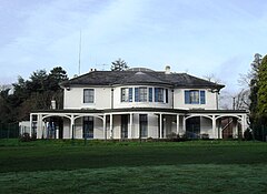
Broadfield House is a 19th-century villa-style house in the Broadfield neighbourhood of Crawley, a town and borough in West Sussex, England. Built in 1830 on the extensive land of the Tilgate Estate south of the small market town of Crawley, it was extended later in the 19th century and converted into a country club. After World War II, Crawley was designated a New Town and had to prepare for rapid, strictly planned growth. Broadfield House was chosen as the headquarters of the Crawley Development Corporation, and became the base where all the decisions that shaped Crawley's future were made. The house, which is still set in parkland, was refurbished and converted for use by Discovery School in 2011. It has been listed at Grade II by English Heritage for its architectural and historical importance.
Crawley Development Corporation was set up in February 1947 by the Government of the United Kingdom to establish, administer and control the development of the New Town of Crawley in accordance with the New Towns Act 1946. The Corporation had the task of growing the ancient Sussex market town of Crawley from a population of 9,000 to 40,000 by the early 1960s, expanding its commercial and industrial base and developing a balanced, socially cohesive community. A master plan supplied by planning consultant Anthony Minoprio would guide the Corporation's work. The "energy and enthusiasm" of its chairman Thomas Bennett helped it meet many of its targets early, and it was formally dissolved in 1962. Its assets passed to the Commission for New Towns in that year; they are now owned privately or by the local authority, Crawley Borough Council.
As of November 2010, there were 59 locally listed buildings in Crawley, a town and borough in the county of West Sussex in southeast England. One of these has subsequently been demolished. A locally listed building is defined as "a building, structure or feature that, whilst not statutorily listed by the Secretary of State, the Council considers to be an important part of Crawley's heritage due to its architectural, historic or archaeological significance". Crawley Borough Council administers the selection and deselection process, defines the criteria for inclusion, and produces and updates the local list.
Forge Wood is the 14th residential neighbourhood in Crawley, a town and borough in West Sussex. The 1,900 houses and other facilities will be built on open land in the northeast of the borough, adjoining the ancient village of Tinsley Green and to the north of the Pound Hill neighbourhood.
This page is based on this Wikipedia article Text is available under the CC BY-SA 4.0 license; additional terms may apply. Images, videos and audio are available under their respective licenses.