Dyers Almshouses

Last updated

Dyers Almshouses
Dyers' Almshouses, Northgate, Crawley (2).JPG
The north side of the almshouses
Crawley UK location map.svg
Red pog.svg
Location of the almshouses within Crawley
General information
Type Almshouse
Architectural style Dutch Vernacular/Arts and Crafts
AddressNorthgate Road, Northgate RH10 1YD
Town or city Crawley
CountryUnited Kingdom
Coordinates 51°07′06″N0°11′13″W / 51.1184°N 0.1870°W / 51.1184; -0.1870 Coordinates: 51°07′06″N0°11′13″W / 51.1184°N 0.1870°W / 51.1184; -0.1870
Groundbreaking1939
OpenedOctober 1940 (first block)
Owner Worshipful Company of Dyers
Design and construction
Architecture firmBertram and Company (W.H. Hatchard-Smith)
Main contractorLongley and Company
Designations Locally listed building

The Dyers Almshouses are a group of 30 almshouses belonging to the Worshipful Company of Dyers, a London Livery Company. Built in three stages between 1939 and 1971, they are located close to the town centre of Crawley, a New Town and borough in West Sussex, England. The distinctive Arts and Crafts-influenced buildings are arranged around a courtyard on a street close to Crawley town centre, and have been granted conservation area and locally listed building status.

Contents

History

The Worshipful Company of Dyers received its royal charter in 1471, but the profession had a presence in the City of London from the late 12th century. [1] The company's first almshouse dated from 1545, when Robert Tyrwhitt MP gave the company a messuage in London. Over the next 200 years, another 25 houses were built across London. In 1840, a group of 26 almshouses was built in Islington in North London to replace these older buildings. [2]

Before World War II, Crawley was a slowly growing market town based around a north–south High Street. Beyond the buildings fronting the road, ancient fields and allotments survived. [3] Towards the north end of the street, a footpath ran southeastwards between buildings and through the fields.[ citation needed ] In the 1930s this footpath was upgraded into a long cul-de-sac called Northgate Road, [4] taking its name from the nearby northern tollgate on the High Street—part of the main London–Brighton road which was turnpiked in the 18th century. [5]

The almshouses are arranged around a landscaped courtyard. Dyers' Almshouses, Northgate, Crawley (November 2008).JPG
The almshouses are arranged around a landscaped courtyard.

The road was mostly developed with "typical 1930s" terraced and semi-detached houses, [4] [6] but a site on the north side was acquired by the Worshipful Company of Dyers in 1939 with money received from the sale of the Islington almshouses. They commissioned London-based architects Bertram and Company (the scheme architect was W.H. Hatchard-Smith) [7] to design, and Crawley firm Longley and Company to build, ten new houses and accommodation for a warden. [2] [8] Construction was stopped temporarily when World War II broke out, but Longley and Company resumed a few weeks later when it became clear that "the expected bombing and gassing" was not imminent. [9] These first houses were finished in October 1940. [8] Another 16 houses were built in the same style in 1952 when money was left to the company, and in 1971 (the quincentennial of the granting of the royal charter) another four houses were added. [8] Two are now used for other purposes (a common room and accommodation for a matron), leaving 28 in use by residents. A mixture of couples and single people occupy the houses; the criteria set by the company are that applicants should be "of good character and modest means". Applicants must write to the Company clerk and go through an interview, after which they are placed on a list for a house. [2] [8] Most residents are retired people who have previously lived in Crawley or who have family connections to the town. [2]

Modernisation work in the early 21st century has included the replacement of all windows with double glazing, a new heating system, rewiring and improvements to the drains. [2] A planning application was made in 2011 to convert some of the landscaped area in front of the almshouses into a gravel car park for up to ten vehicles. [4] Parking in the area had long been a problem: a "controlled parking zone" was put in place on Northgate Road in 2002, limiting parking to 16 spaces. The almshouses were excluded from this because few residents had cars and Crawley town centre was considered close enough to be accessible: it is 440 yards (400 m) away. Subsequently, four parking permits were granted for almshouse residents, and some visitor permits were allocated as well—but this facility was taken away in 2010 because of increasing demand for spaces. Extension of the adjacent Three Bridges controlled parking zone was discussed as an alternative. [10] [11]

Architecture

W.H. Hatchard-Smith [7] of London architects Bertram and Company designed the Dyers Almshouses, which are "a good example of a comprehensively planned group of residential buildings" and are a significant historical feature in relation to Crawley's transition from market town to carefully planned postwar New Town. [8] In design, they share features with "rural Dutch cottages" while being mostly in the Arts and Crafts style. [8] [12] There are no other buildings of this style either in Crawley or in nearby areas of Sussex. [8] At the time they were built, local building firm Longley and Company were working on dozens of commissions in the area, particularly for the Crawley Development Corporation in relation to the New Town masterplan, [13] but most of their work was architecturally unassuming: New Town buildings were typically "run-of-the-mill, curtain-walled ... [with] a reassuring uniformity with nothing regimented about it". [14] Accordingly, the almshouses stand out: they have large and ornate brick chimney-stacks, steep roofs reaching nearly to ground level, deep tile-hung gables and stock brick walls in two shades of red (darker brick is used around the windows). Heavy Tudor-style oak doors with iron door furniture survive. [8] [12] Some of the iron drainpipes from the old almshouses at Islington were apparently recovered when they were sold and were reinstated on the new buildings: several bear the date 1852. [8] The buildings surround a quadrangle-style courtyard with formal planting, low walls, fences and hedges, telephone boxes and a former boiler-house. [8]

Heritage

The houses have large tile-hung gables and chimney-stacks. Dyers Almshouses, Northgate, Crawley (Close-up of one House).JPG
The houses have large tile-hung gables and chimney-stacks.

Crawley Borough Council designated the Dyers Almshouses as a conservation area on 15 October 1996, and its formal conservation area character statement was ratified on 18 November 1997. [2] As of March 2013, it is one of eight conservation areas in the borough of Crawley, [15] although a consultation is ongoing which could result in five new areas being designated (two of which are extensions to existing conservation areas). [16] The definition of a conservation area is a principally urban area "of special architectural or historic interest, the character or appearance of which it is desirable to preserve or enhance". Such areas are identified according to criteria defined by Sections 69 and 70 of the Planning (Listed Buildings and Conservation Areas) Act 1990. [17] Crawley Borough Council adds to the statutory definition by stating that the status is granted on the basis of "a number of factors and does not solely relate to the age of the buildings; for instance architectural interest and setting of an area are also important factors." [15] In granting conservation area status, the council aimed to "protect the distinctive character and appearance of the Almshouses and their landscaped trees and gardens" and to ensure that any development in the surrounding area was appropriate and had no negative impact—especially as to the east lies a site earmarked for large-scale residential development. [18]

Collectively, the almshouses are also one of 58 locally listed buildings in Crawley. [12] This defines them as "building[s ...] that, whilst not statutorily listed by the Secretary of State, the council considers to be an important part of Crawley's heritage due to [their] architectural, historic or archaeological significance". Crawley Borough Council administers the selection and deselection process, defines the criteria for inclusion, and produces and updates the local list. [19]

See also

Related Research Articles

<span class="mw-page-title-main">Crawley</span> Town and borough in West Sussex, England

Crawley is a large town and borough in West Sussex, England. It is 28 miles (45 km) south of London, 18 miles (29 km) north of Brighton and Hove, and 32 miles (51 km) north-east of the county town of Chichester. Crawley covers an area of 17.36 square miles (44.96 km2) and had a population of 106,597 at the time of the 2011 Census.

<span class="mw-page-title-main">Worshipful Company of Dyers</span> Livery company of the City of London

The Worshipful Company of Dyers is one of the Livery Companies of the City of London. The Dyers' Guild existed in the twelfth century; it received a Royal Charter in 1471. It originated as a trade association for members of the dyeing industry but is now mainly a charitable institution. Each year the company participates in the ceremony of Swan Upping along the River Thames.

<span class="mw-page-title-main">Southgate, West Sussex</span> Human settlement in England

Southgate is one of the 14 residential neighbourhoods in Crawley, a town and borough in West Sussex, England. Crawley was planned and laid out as a New Town after the Second World War, based on the principle of self-contained neighbourhoods surrounding a town centre of civic and commercial buildings. Southgate was one of the four in the "inner ring" closest to the town centre, and was intended to be the largest of the nine designed in the original master plan. It was built in two stages between the 1950s and the 1970s, but retains some older buildings from before the New Town era and has "significant areas of pre-New Town character".

<span class="mw-page-title-main">West Green, West Sussex</span> Human settlement in England

West Green is one of the 14 residential neighbourhoods in Crawley, a town and borough in West Sussex, England. Crawley was planned and laid out as a New Town after the Second World War, based on the principle of self-contained neighbourhoods surrounding a town centre of civic and commercial buildings. West Green was the first neighbourhood to be developed, and is one of the smallest and closest to the town centre.

<span class="mw-page-title-main">Northgate, West Sussex</span> Neighbourhood in Crawley, England

Northgate is one of the 14 residential neighbourhoods in Crawley, a town and borough in West Sussex, England. Crawley was planned and laid out as a New Town after the Second World War, based on the principle of self-contained neighbourhoods surrounding a town centre of civic and commercial buildings. Northgate was one of the four in the "inner ring" closest to the town centre, and was the second to be completed: almost all building work on the 168-acre (68 ha) site took place in the first half of the 1950s.

<span class="mw-page-title-main">Listed buildings in Crawley</span>

As of 2011 there were 102 listed buildings and structures in the English borough of Crawley, West Sussex. Two others have subsequently gained listed status. The Borough of Crawley is based on the town of the same name, located approximately halfway between London and Brighton. Although Crawley expanded substantially after World War II when it was designated a New Town by an Act of Parliament, many older buildings remain.

<span class="mw-page-title-main">Tree House, Crawley</span> Open hall-house in High Street, Crawley

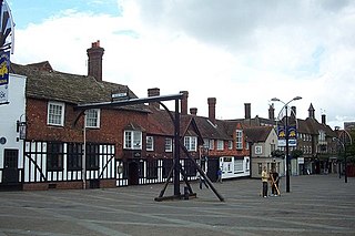
Tree House, also known as The Tree, is a medieval timber-framed house on the High Street in Crawley, a town and borough in West Sussex, England. It is the original manor house of Crawley, and was built in the early 15th century and rebuilt in the mid-16th century. It now has a modern exterior, but the old structure is still in place inside. Situated in a prominent position facing both the High Street and The Boulevard, two of Crawley town centre's main roads, its name commemorates an ancient elm tree which stood outside for hundreds of years and was one of Crawley's landmarks.

<span class="mw-page-title-main">Lowfield Heath</span> Human settlement in England

Lowfield Heath is a former village within the boundaries of the Borough of Crawley, West Sussex, England. Situated on the main London to Brighton road approximately 27 miles (43 km) south of London and 2 miles (3.2 km) north of Crawley, it was gradually rendered uninhabitable by the expansion of London Gatwick Airport immediately to the north.

<span class="mw-page-title-main">White Hart Inn, Crawley</span> Historic site in West Sussex , England

The White Hart Inn, also known as the White Hart Hotel, is a coaching inn on the High Street in Crawley, a town and borough in West Sussex, England. Built in the late 18th century to replace an older inn also under the sign of the White Hart, it also served as Crawley's main post office for most of the 19th century, and still operates as a public house in the 21st century. Its partly timber-framed structure, which incorporates part of an early 17th-century building, is characteristic of the area. It is designated a Grade II Listed building.

<span class="mw-page-title-main">Tinsley Green, West Sussex</span> Human settlement in England

Tinsley Green is an area in the Borough of Crawley, one of seven local government districts in the English county of West Sussex. Originally a hamlet in the parish of Worth, it was absorbed by the New Town of Crawley in the 1940s and became part of the Pound Hill neighbourhood. As well as houses, farms and woodland, it became the site of the 1930s aerodrome at Gatwick—now London Gatwick Airport. The airport's first railway station was briefly known as Tinsley Green. The game of marbles has a strong local tradition, and Tinsley Green's pub hosts the British and World Marbles Championship each year.

<span class="mw-page-title-main">Brewery Shades</span> Historic site in West Sussex , England

The Brewery Shades is a public house on the High Street in Crawley, a town and borough in West Sussex, England. The building, which stands on a corner site at the point where the town's ancient High Street meets the commercial developments of the postwar New Town, has been altered and extended several times; but at its centre is a 15th-century timber-framed open hall-house of a type common in the Crawley area in the Middle Ages. Few now survive, and the Brewery Shades has been protected as a Grade II listed building.

<span class="mw-page-title-main">Broadfield House, Crawley</span> Historic site in West Sussex , England

Broadfield House is a 19th-century villa-style house in the Broadfield neighbourhood of Crawley, a town and borough in West Sussex, England. Built in 1830 on the extensive land of the Tilgate Estate south of the small market town of Crawley, it was extended later in the 19th century and converted into a country club. After World War II, Crawley was designated a New Town and had to prepare for rapid, strictly planned growth. Broadfield House was chosen as the headquarters of the Crawley Development Corporation, and became the base where all the decisions that shaped Crawley's future were made. The house, which is still set in parkland, was refurbished and converted for use by Discovery School in 2011. It has been listed at Grade II by English Heritage for its architectural and historical importance.

<span class="mw-page-title-main">Friary Church of St Francis and St Anthony, Crawley</span> Church in West Sussex , United Kingdom

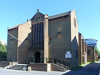
The Friary Church of St Francis and St Anthony is a Roman Catholic church in Crawley, a town and borough in West Sussex, England. The town's first permanent place of Roman Catholic worship was founded in 1861 next to a friary whose members, from the Order of Friars Minor Capuchin, had been invited to the area by a wealthy local family of Catholic converts. Crawley's transformation from a modest market town to a rapidly growing postwar New Town in the mid-20th century made a larger church necessary, and in the late 1950s the ecclesiastical architect Harry Stuart Goodhart-Rendel was commissioned to build a new church. The friary closed in 1980 and has been demolished, but the large brick church still stands in a commanding position facing the town centre. English Heritage has listed the building at Grade II for its architectural and historical importance.

<span class="mw-page-title-main">The George Hotel, Crawley</span> Hotel and former coaching inn in England

The George Hotel, also known as the George Inn and now marketed as the Ramada Crawley Gatwick, is a hotel and former coaching inn on the High Street in Crawley, a town and borough in West Sussex, England. The George was one of the country's most famous and successful coaching inns, and the most important in Sussex, because of its location halfway between the capital city, London, and the fashionable seaside resort of Brighton. Cited as "Crawley's most celebrated building", it has Grade II* listed status.

<span class="mw-page-title-main">Crawley Development Corporation</span>

Crawley Development Corporation was set up in February 1947 by the Government of the United Kingdom to establish, administer and control the development of the New Town of Crawley in accordance with the New Towns Act 1946. The Corporation had the task of growing the ancient Sussex market town of Crawley from a population of 9,000 to 40,000 by the early 1960s, expanding its commercial and industrial base and developing a balanced, socially cohesive community. A master plan supplied by planning consultant Anthony Minoprio would guide the Corporation's work. The "energy and enthusiasm" of its chairman Thomas Bennett helped it meet many of its targets early, and it was formally dissolved in 1962. Its assets passed to the Commission for New Towns in that year; they are now owned privately or by the local authority, Crawley Borough Council.

<span class="mw-page-title-main">Locally listed buildings in Crawley</span>

As of November 2010, there were 59 locally listed buildings in Crawley, a town and borough in the county of West Sussex in southeast England. One of these has subsequently been demolished. A locally listed building is defined as "a building, structure or feature that, whilst not statutorily listed by the Secretary of State, the Council considers to be an important part of Crawley's heritage due to its architectural, historic or archaeological significance". Crawley Borough Council administers the selection and deselection process, defines the criteria for inclusion, and produces and updates the local list.

<span class="mw-page-title-main">Fernhill, West Sussex</span>

Fernhill is a hamlet close to Gatwick Airport in West Sussex, England. Its fields and farmhouses formerly straddled the county boundary between Surrey and West Sussex, but since 1990 the whole area has been part of the county of West Sussex and the borough of Crawley. Fernhill is bounded on three sides by motorways and the airport. A fatal aeroplane crash occurred here in 1969.

<span class="mw-page-title-main">Public services in Crawley</span>

Crawley, a postwar New Town and borough in the English county of West Sussex, has a wide range of public services funded by national government, West Sussex County Council, Crawley Borough Council and other public-sector bodies. Revenue to fund these services comes principally from Council Tax. Some of Crawley's utilities and infrastructure are provided by outside parties, such as utility companies and West Sussex County Council, rather than by the borough council. To help pay for improved infrastructure and service provision in proposed major residential developments such as Kilnwood Vale and the North East Sector, the borough council has stated that as part of the Crawley Local Plan it would require developers to pay a Community Infrastructure Levy.

References

Notes

  1. "The Worshipful Company of Dyers: A City of London Livery Company". Worshipful Company of Dyers. 2013. Archived from the original on 2 March 2013. Retrieved 25 March 2013.
  2. 1 2 3 4 5 6 "The Worshipful Company of Dyers: A City of London Livery CompanyThe Dyers Almshouses". Worshipful Company of Dyers. 2013. Archived from the original on 4 March 2016. Retrieved 25 March 2013.
  3. Goepel 1980 , pp. 4–5.
  4. 1 2 3 "Planning Application Ref No: CR/2011/0088/FUL" (PDF). Crawley Borough Council. 11 April 2011. Archived (PDF) from the original on 4 March 2016. Retrieved 25 March 2013. Dyers Almshouses, Northgate Road, Northgate: Provision of two Gravel Surfaced parking areas
  5. Hudson, T. P., ed. (1987). "A History of the County of Sussex: Volume 6 Part 3 – Bramber Rape (North-Eastern Part) including Crawley New Town. Ifield". Victoria County History of Sussex. British History Online. pp. 53–60. Retrieved 25 March 2013.
  6. Gwynne 1990 , p. 145.
  7. 1 2 Smith 1983 , p. 52.
  8. 1 2 3 4 5 6 7 8 9 10 "Conservation Area Statement: Dyers Company Almshouses Conservation Area". Crawley Borough Council. December 1998. Archived from the original on 29 August 2012. Retrieved 25 March 2013.
  9. Gwynne 1990 , p. 150.
  10. "Email response sent by the Deputy Leader on 15th November 2010" (PDF). West Sussex County Council. 15 November 2010. Archived (PDF) from the original on 3 March 2016. Retrieved 25 March 2013.
  11. "Proposal to extend Three Bridges parking zone". Sussex Safer Roads Partnership. 9 February 2011. Archived from the original on 16 February 2011. Retrieved 25 March 2013.
  12. 1 2 3 Crawley Borough Council 2010 , p. 7.
  13. Smith 1983 , pp. 49–51.
  14. Nairn & Pevsner 1965 , pp. 203–204.
  15. 1 2 "Conservation Areas". Crawley Borough Council. 21 January 2013. Archived from the original on 24 June 2012. Retrieved 25 March 2013.
  16. "New Conservation Areas for Crawley". Crawley Borough Council. 20 March 2013. Archived from the original on 24 April 2013. Retrieved 25 March 2013.
  17. "Planning (Listed Buildings and Conservation Areas) Act 1990 (c. 9)". The UK Statute Law Database. Ministry of Justice. 24 May 1990. Archived from the original on 12 December 2012. Retrieved 25 March 2013.
  18. "Dyers Almshouses Conservation Area". Crawley Borough Council. 19 February 2013. Archived from the original on 4 March 2016. Retrieved 25 March 2013.
  19. Crawley Borough Council 2010 , p. 1.

Bibliography

  • Crawley Borough Council (November 2010). Crawley Local Building List (Report). Crawley Borough Council. Archived from the original on 29 August 2012. Retrieved 10 February 2013.
  • Goepel, J. (1980). The Development of Crawley. Crawley: Crawley Borough Council.
  • Gwynne, Peter (1990). A History of Crawley (1st ed.). Chichester: Phillimore & Co. ISBN   0-85033-718-6.
  • Nairn, Ian; Pevsner, Nikolaus (1965). The Buildings of England: Sussex. Harmondsworth: Penguin Books. ISBN   0-14-071028-0.
  • Smith, Rhonda (1983). Longleys of Crawley: a Pictorial History of James Longley & Co. Crawley: James Longley & Co. Ltd. ISBN   0-9507880-0-7.