History
By the early 19th century, the market town of Crawley—founded six centuries earlier on the ancient London–Brighton road, [1] about halfway between the two places—was thriving as a centre of population and commerce. The conversion of the road to a turnpike in the late 18th century had made both London and the fashionable seaside resort of Brighton much more accessible, and Crawley was the natural stopping-off point during the journey. [2] Rich families and gentry who needed easy access to London began building estates and mansions in the Crawley area. [3] [4] One of the largest was the Tilgate Estate, which covered 2,185 acres (884 ha) of woodland and open land [5] south of Crawley around the Brighton Road. [6] [7]
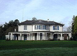
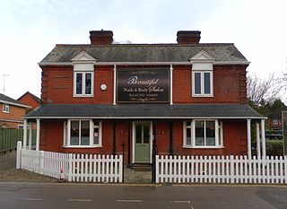
The main building on the estate was Tilgate Mansion, demolished in the 1950s, [8] but in 1830 a villa-style house was built in the grounds just west of the Brighton Road. [3] Broadfield House, which was decorated in the Greek Revival style inside, had bow-fronted façades and a columned verandah facing a lake. [9] [10] In the 1860s, another wing was added on the west side to provide a hall with a gallery. [9] For many years, the building—large, surrounded by parkland and in a semi-rural setting—was used as a hotel and country club, [11] as Crawley developed into a slowly growing, prosperous small town.
In 1945, as soon as World War II ended, government ministers and regional planning committees began to address the problem of London-centric living and employment. London was considered to be overcrowded and affected by slum development, made worse by extensive wartime damage. New Towns—planned, self-contained communities on sites in southeast England with plenty of room for expansion—were proposed. [12] The Ministry of Town and Country Planning's southeast office reported that the Crawley area had suffered haphazard, poorly planned development since the estates were divided up and sold off in the early 20th century, and would therefore be an appropriate candidate for properly planned high-density development. [11] Rapid progress was made: the decision to designate Crawley as a New Town (Britain's second) was made public on 12 July 1946, [13] a preliminary planning committee was set up in September of that year, the New Towns Act 1946 was passed shortly afterwards to give the government authority to carry out the planning and building of New Towns, a 6,000-acre (2,400 ha) area around Crawley was legally defined in January 1947, and the Crawley Development Corporation was established in February 1947. [14] Architect Sir Thomas Bennett was appointed chairman of the committee of financial officers, engineers, technicians, surveyors and other professionals. [15]
The Development Corporation needed somewhere to work from. They did not want to build new offices; instead they waited for suitable premises to come up for sale in Crawley. For the first few months, they used temporary offices in London; but at the end of 1947, Broadfield House (still in use until then as a country club) was closed down and put up for sale. [16] On 23 August 1948, the building reopened as the official headquarters of Crawley Development Corporation, which at that time had 90 employees. [16] [17] More buildings were constructed in the grounds, to house architects and engineers; Crawley-based building firm James Longley & Co. started work on the extension in March 1949 and finished a few months later. [16] [18]
Crawley Development Corporation was dissolved in 1964. It had successfully developed nine residential neighbourhoods, shopping and civic space and an industrial estate and increased Crawley's population from about 9,000 to 59,000 in 17 years. [19] Broadfield House was converted into offices for Crawley Urban District Council, the local authority created in 1956 to govern the town. [20] (This became Crawley Borough Council when the borough was incorporated in 1974.) [11] In 1984, the building was acquired by newly formed FM radio station Radio Mercury, which began broadcasting to West Sussex and Surrey on 20 October of that year on 103.6.FM and later, on 102.7 FM. [21] The radio station later relocated to offices on the Manor Royal industrial estate, [22] and by 2008 the building was mostly vacant. At that time a planning application was lodged with Crawley Borough Council to convert the building into 12 flats. [23] Permission was granted a few months later, [24] however the development did not proceed. Broadfield House was restored in 2011, and was purchased and converted for use by Discovery New School at a cost of £1.9 million. [25] Funding for the refurbishment of Broadfield House included grants from central government. [26] [27]

Crawley is a town and borough in West Sussex, England. It is 28 miles (45 km) south of London, 18 miles (29 km) north of Brighton and Hove, and 32 miles (51 km) north-east of the county town of Chichester. Crawley covers an area of 17.36 square miles (44.96 km2) and had a population of 106,597 at the time of the 2011 Census.

Southgate is one of the 14 residential neighbourhoods in Crawley, a town and borough in West Sussex, England. Crawley was planned and laid out as a New Town after the Second World War, based on the principle of self-contained neighbourhoods surrounding a town centre of civic and commercial buildings. Southgate was one of the four in the "inner ring" closest to the town centre, and was intended to be the largest of the nine designed in the original master plan. It was built in two stages between the 1950s and the 1970s, but retains some older buildings from before the New Town era and has "significant areas of pre-New Town character".

West Green is one of the 14 residential neighbourhoods in Crawley, a town and borough in West Sussex, England. Crawley was planned and laid out as a New Town after the Second World War, based on the principle of self-contained neighbourhoods surrounding a town centre of civic and commercial buildings. West Green was the first neighbourhood to be developed, and is one of the smallest and closest to the town centre.

Broadfield is one of 14 neighbourhoods within the town of Crawley in West Sussex, England. Broadfield is located in the south west of the town. It is bordered by Bewbush to the north, Southgate to the north east and Tilgate to the east.

Tilgate is one of 14 neighbourhoods within the town of Crawley in West Sussex, England. The area contains a mixture of privately developed housing, self-build groups and ex-council housing. It is bordered by the districts of Furnace Green to the north east, Southgate to the north west and Broadfield to the south west.

Northgate is one of the 14 residential neighbourhoods in Crawley, a town and borough in West Sussex, England. Crawley was planned and laid out as a New Town after the Second World War, based on the principle of self-contained neighbourhoods surrounding a town centre of civic and commercial buildings. Northgate was one of the four in the "inner ring" closest to the town centre, and was the second to be completed: almost all building work on the 168-acre (68 ha) site took place in the first half of the 1950s.

Thomas Bennett Community College (TBCC) is a secondary school with academy status for pupils aged 11 to 19. It caters to approximately 1200 pupils in Years 7 to 14, including 160 in its sixth form.

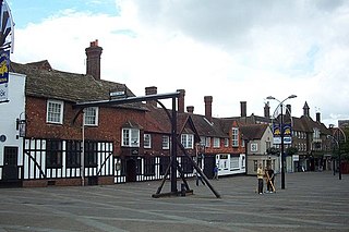
As of 2011 there were 102 listed buildings and structures in the English borough of Crawley, West Sussex. Two others have subsequently gained listed status. The Borough of Crawley is based on the town of the same name, located approximately halfway between London and Brighton. Although Crawley expanded substantially after World War II when it was designated a New Town by an Act of Parliament, many older buildings remain.

The Ancient Priors is a medieval timber-framed hall house on the High Street in Crawley, a town and borough in West Sussex, England. It was built in approximately 1450, partly replacing an older structure—although part of this survives behind the present street frontage. It has been expanded, altered and renovated many times since, and fell into such disrepair by the 1930s that demolition was considered. It has since been refurbished and is now a restaurant, although it has been put to various uses during its existence. Secret rooms, whose purpose has never been confirmed for certain, were discovered in the 19th century. English Heritage has listed the building at Grade II* for its architectural and historical importance, and it has been described as Crawley's "most prestigious medieval building" and "the finest timber-framed house between London and Brighton".

The White Hart Inn, also known as the White Hart Hotel, is a coaching inn on the High Street in Crawley, a town and borough in West Sussex, England. Built in the late 18th century to replace an older inn also under the sign of the White Hart, it also served as Crawley's main post office for most of the 19th century, and still operates as a public house in the 21st century. Its partly timber-framed structure, which incorporates part of an early 17th-century building, is characteristic of the area. It is designated a Grade II Listed building.

Tinsley Green is an area in the Borough of Crawley, one of seven local government districts in the English county of West Sussex. Originally a hamlet in the parish of Worth, it was absorbed by the New Town of Crawley in the 1940s and became part of the Pound Hill neighbourhood. As well as houses, farms and woodland, it became the site of the 1930s aerodrome at Gatwick—now London Gatwick Airport. The airport's first railway station was briefly known as Tinsley Green. The game of marbles has a strong local tradition, and Tinsley Green's pub hosts the British and World Marbles Championship each year.

The Brewery Shades is a public house on the High Street in Crawley, a town and borough in West Sussex, England. The building, which stands on a corner site at the point where the town's ancient High Street meets the commercial developments of the postwar New Town, has been altered and extended several times; but at its centre is a 15th-century timber-framed open hall-house of a type common in the Crawley area in the Middle Ages. Few now survive, and the Brewery Shades has been protected as a Grade II listed building.
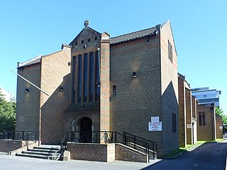
The Friary Church of St Francis and St Anthony is a Roman Catholic church in Crawley, a town and borough in West Sussex, England. The town's first permanent place of Roman Catholic worship was founded in 1861 next to a friary whose members, from the Order of Friars Minor Capuchin, had been invited to the area by a wealthy local family of Catholic converts. Crawley's transformation from a modest market town to a rapidly growing postwar New Town in the mid-20th century made a larger church necessary, and in the late 1950s the ecclesiastical architect Harry Stuart Goodhart-Rendel was commissioned to build a new church. The friary closed in 1980 and has been demolished, but the large brick church still stands in a commanding position facing the town centre. English Heritage has listed the building at Grade II for its architectural and historical importance.
The George Hotel, also known as the George Inn and now marketed as the Ramada Crawley Gatwick, is a hotel and former coaching inn on the High Street in Crawley, a town and borough in West Sussex, England. The George was one of the country's most famous and successful coaching inns, and the most important in Sussex, because of its location halfway between the capital city, London, and the fashionable seaside resort of Brighton. Cited as "Crawley's most celebrated building", it has Grade II* listed status.
Crawley Development Corporation was set up in February 1947 by the Government of the United Kingdom to establish, administer and control the development of the New Town of Crawley in accordance with the New Towns Act 1946. The Corporation had the task of growing the ancient Sussex market town of Crawley from a population of 9,000 to 40,000 by the early 1960s, expanding its commercial and industrial base and developing a balanced, socially cohesive community. A master plan supplied by planning consultant Anthony Minoprio would guide the Corporation's work. The "energy and enthusiasm" of its chairman Thomas Bennett helped it meet many of its targets early, and it was formally dissolved in 1962. Its assets passed to the Commission for New Towns in that year; they are now owned privately or by the local authority, Crawley Borough Council.
As of November 2010, there were 59 locally listed buildings in Crawley, a town and borough in the county of West Sussex in southeast England. One of these has subsequently been demolished. A locally listed building is defined as "a building, structure or feature that, whilst not statutorily listed by the Secretary of State, the Council considers to be an important part of Crawley's heritage due to its architectural, historic or archaeological significance". Crawley Borough Council administers the selection and deselection process, defines the criteria for inclusion, and produces and updates the local list.
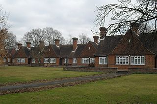
The Dyers Almshouses are a group of 30 almshouses belonging to the Worshipful Company of Dyers, a London Livery Company. Built in three stages between 1939 and 1971, they are located close to the town centre of Crawley, a New Town and borough in West Sussex, England. The distinctive Arts and Crafts-influenced buildings are arranged around a courtyard on a street close to Crawley town centre, and have been granted conservation area and locally listed building status.

Crawley, a postwar New Town and borough in the English county of West Sussex, has a wide range of public services funded by national government, West Sussex County Council, Crawley Borough Council and other public-sector bodies. Revenue to fund these services comes principally from Council Tax. Some of Crawley's utilities and infrastructure are provided by outside parties, such as utility companies and West Sussex County Council, rather than by the borough council. To help pay for improved infrastructure and service provision in proposed major residential developments such as Kilnwood Vale and the North East Sector, the borough council has stated that as part of the Crawley Local Plan it would require developers to pay a Community Infrastructure Levy.