Kingsessing is a neighborhood in the Southwest section of Philadelphia, Pennsylvania, United States, located next to the neighborhoods of Cedar Park, Southwest Schuylkill, and Mount Moriah, as well as the borough of Yeadon in Delaware County. It is roughly bounded by Cobbs Creek and 60th Street to the southwest, Woodland Avenue to the southeast, 53rd Street to the northeast, and Baltimore Avenue to the northwest.

Fox Chase is a neighborhood in Northeast Philadelphia, Pennsylvania.

Overbrook is a neighborhood northwest of West Philadelphia, Philadelphia, in the U.S. state of Pennsylvania. The area's housing ranges from large, old homes to rowhouses to 3- and 4-story apartment buildings.

West Kensington is a neighborhood in the North Philadelphia section of Philadelphia. It is north of Olde Kensington. The Market Frankford El above Front Street forms the line between West Kensington and Kensington. Its bordering neighborhoods are Kensington to the east, Harrowgate to the northeast, and Fairhill to the west. It is bounded by Kensington Avenue to the east, American Street to the west, York Street to the South and Allegheny Avenue to the north.

Grays Ferry, also known as Gray's Ferry, is a neighborhood in South Philadelphia bounded (roughly) by 25th Street on the east, the Schuylkill River on the west, Vare Avenue on the south, and Grays Ferry Avenue on the north. The section of this neighborhood west of 34th Street is also known as Forgotten Bottom. Grays Ferry shares borders with Southwest Center City to the North, Point Breeze to the East, and Girard Estate to the South. Gray’s Ferry is across from where Mill Creek debouches at about 43rd street. Historically, Grays Ferry was one of the largest enclaves of Irish Americans in the city, and while there are still many Irish left, it is now home to a significant African American population.

Hartranft is a neighborhood in the central part of North Philadelphia section of Philadelphia, Pennsylvania, United States.
Overbrook Farms is a neighborhood on the western edge of the West Philadelphia section of Philadelphia, Pennsylvania, United States. It is roughly bounded by City Avenue, 58th Street, Woodbine Avenue, and 66th Street at Morris Park. The neighborhood is bisected by Lancaster Avenue and the original Pennsylvania Railroad "main line". Today the rail line is used by both Amtrak passenger service and SEPTA's commuter Paoli/Thorndale Line.

Haddington is a neighborhood in the West Philadelphia section of Philadelphia, Pennsylvania. Its borders are defined as Haverford Avenue/Girard Avenue to the north, 52nd Street to the east, Market Street to the south, and 67th Street to the most western edge of the neighborhood. It is a largely African American community of mostly two-story rowhouses with a large proportion of elderly residents and a high home-ownership rate. Near the intersection of Vine Street and 56th Street, new construction and community facilities were built in the 1970s thanks to the Haddington Leadership Organization.

Parkside is a neighborhood in the West Philadelphia section of Philadelphia, Pennsylvania, USA. Much of the Parkside neighborhood was built during the 1876 Centennial Exhibition. It is a National Register of Historic Places Historic District with many examples of Victorian architecture, some well-preserved, others in poor condition. The neighborhood was populated by German Americans, followed by Eastern European Jews, before becoming heavily African American after World War II.

Burholme Park is a public park in the Burholme neighborhood of Philadelphia. The park and the Robert W. Ryerss Museum and Library was a gift of the last descendant of the Ryerss family, prominent Philadelphians. Robert W. Ryerss died on Feb. 18, 1895 at age 65, leaving his estate to Mary Reed, his wife of eight months and the head housekeeper of the Ryerss Mansion for 27 years. He left everything to her on the condition that upon her death the best part of his land and much of his estate would be left to the “People of Philadelphia, forever” as a museum and public lending library. Mary Reed Ryerss spent the rest of her life traveling around the world collecting objects for the museum and planning for the library and park.
Garden Court is a neighborhood in the West Philadelphia section of Philadelphia, Pennsylvania. It is located west of Spruce Hill, north of Cedar Park, east of Cobbs Creek, and south of Walnut Hill.

Castor Gardens is a neighborhood in the lower Northeast section of Philadelphia, Pennsylvania, United States. Castor Gardens' borders are ill-defined, but it exists in the vicinity of Castor Avenue and Cottman Avenue. It is also near Roosevelt Boulevard. The neighborhood can either be entered from the south, by taking the Oxford Circle exit of Roosevelt Boulevard, or from the north, by taking the Cottman Avenue exit. Adjacent neighborhoods are Mayfair, Lawndale, Burholme, Oxford Circle, and Rhawnhurst.
Ryers is a neighborhood in Northeast Philadelphia. Ryers is bounded by Cottman Avenue on the southwest, Fillmore Street on the northwest. Both of these highways separate Philadelphia from Cheltenham and Rockledge, Montgomery County. The Fox Chase Line separates Ryers from Burholme and Fox Chase borders it via Hartel St. on the northeast.
Ryerss Mansion, also known as Burholme Mansion, is a historic mansion in the Fox Chase neighborhood of Philadelphia, Pennsylvania.
Wister is a neighborhood in Northwest Philadelphia, Pennsylvania, United States. It is bounded by Chelten Avenue to the north, Germantown Avenue to the west, Belfield Avenue to the east, and Wister Street to the south. Wister is a section within Germantown. The Clarkson-Watson House, Fisher's Lane, Grumblethorpe, Grumblethorpe Tenant House, and Ivy Lodge are listed on the National Register of Historic Places.
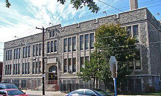
Kennedy Crossan Academics Plus Elementary School is a historic elementary school located in the Burholme neighborhood of Philadelphia, Pennsylvania. It is part of the School District of Philadelphia. The building was designed by Irwin T. Catharine and built in 1922–1924. It is a two-story, nine-bay, brick building on a raised basement in the Late Gothic Revival style. It features a central entrance with arched opening and stone surround and a crenellated brick parapet.

Politz Hebrew Academy, formerly known as William C. Jacobs School and Fayette School, is a historic school located in the Bustleton neighborhood of Philadelphia, Pennsylvania. The building consists of an original section designed by Samuel Sloan in 1855, and the main building built in 1915. The original building is a two-story, stone building sheathed in stucco. The 1915 building is a 2 1/2-story, three-bay, rectangular brick building in the Colonial Revival style. It features a hipped roof and gable dormers.

John Marshall Elementary School is a historic elementary school located in the Frankford neighborhood of Philadelphia, Pennsylvania. It is part of the School District of Philadelphia. The building was designed by Henry deCourcy Richards and built in 1909–1910. It is a three-story, five-bay by three-bay, brick building on a raised basement in the Colonial Revival style. It has a three-story, rear brick addition built in 1922. It features a pedimented cornice, brick parapet, projecting central section, and a two-story arched opening above the main entrance. The school was named for Chief Justice John Marshall.

The Academy for the Middle Years (AMY) Northwest Middle School, formerly the William Levering School, is a historic middle school located in the Roxborough neighborhood of Philadelphia, Pennsylvania. It is part of the School District of Philadelphia.

