
Philadelphia County is the most populous county in Pennsylvania and the 24th-most populous county in the nation. As of the 2020 census, the county had a population of 1,603,797. Its county seat is Philadelphia, the nation's sixth-largest city.

Northern Liberties is a neighborhood in Philadelphia, Pennsylvania, United States. It is north of Center City along the Delaware River. Prior to its incorporation into Philadelphia in 1854, it was among the top 10 largest cities in the U.S. in every census from 1790 to 1850. It was a major manufacturing area that attracted many European immigrants in the late 19th and early 20th centuries. In the early 21st century, it has attracted many young professionals and new commercial and residential development

Philadelphia was an early railroad hub, with lines from all over meeting in Philadelphia. The first railroad in Philadelphia was the Philadelphia, Germantown and Norristown Railroad, opened in 1832 north to Germantown. At the end of 1833, the state-built Philadelphia and Columbia Railroad, part of the Main Line of Public Works, opened for travel to the west, built to avoid loss of travel through Pennsylvania due to projects such as the Erie Canal. At the same time, the north-south leg of the Philadelphia City Railroad opened, running south along Broad Street from the Philadelphia and Columbia.

Kensington is a neighborhood in Philadelphia that belongs to Lower Northeast. As with all neighborhoods in the city, the lack of any official designation means the boundaries of the area vary between sources over time and are disputed among locals. Kensington, as most long-term residents view it, refers generally to the area consisting of Kensington, East Kensington, West Kensington, and Harrowgate. The adjacent Fairhill and Norris Square neighborhoods are more separate but may be included in Kensington; Fishtown and South (Olde) Kensington were historically included. The most conservative boundaries of the neighborhood, shown in the map below, are Front Street and 5th Street to the west, the Amtrak train tracks to the North, Trenton Avenue, the Trenton Avenue train tracks, and Frankford Avenue to the east, and Cecil B. Moore Avenue to the south.
Byberry is a neighborhood in the far northeast section of Philadelphia, in the U.S. state of Pennsylvania. Originally it was incorporated as the Township of Byberry and was the northeasternmost municipality of Philadelphia County before the City and County were consolidated in 1854. Its approximate boundaries are the Poquessing Creek to the north, Woodhaven Road to the south, the Roosevelt Boulevard to the west, and Thornton Road to the east.
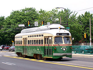
Route 15, the Girard Avenue Line, is a trolley line operated by the Southeastern Pennsylvania Transportation Authority (SEPTA) along Girard Avenue through North and West Philadelphia, Pennsylvania, United States. As of 2007, it is the only surface trolley line in the City Transit Division that is not part of the Subway–Surface Trolley Lines. SEPTA PCC II vehicles are used on the line.
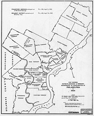
The Act of Consolidation, more formally known as the act of February 2, 1854, is legislation of the Pennsylvania General Assembly that created the consolidated City and County of Philadelphia, expanding the city's territory to the entirety of Philadelphia County and dissolving the other municipal authorities in the county.
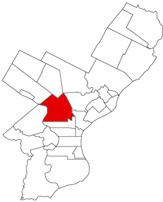
Kensington District, or The Kensington District of the Northern Liberties, was one of the twenty-nine municipalities that formed Philadelphia County, Pennsylvania, United States prior to the enactment of the Act of Consolidation, 1854, when it became incorporated into the newly expanded City of Philadelphia. Lehigh Avenue roughly bounded the district to the north; Germantown Avenue and 6th Street to the west; Cohocksink Creek to the south; and an L-shaped line formed by Frankford Avenue, Norris Street, and York Street to its northeast. The Delaware River was the eastern boundary. Today the area would include the Philadelphia neighborhoods of Olde Kensington, West Kensington and Fishtown, as well as portions of the neighborhoods of Ludlow, Hartranft, Fairhill, Northern Liberties and the current Kensington. The District of Kensington was a self-governing district between the years 1820 and 1854.

Moyamensing is an area of Philadelphia established as a Moyamensing Township during British colonial rule on the fast land of the Neck, lying between Passyunk and Wicaco. It was incorporated into Philadelphia County, Pennsylvania, United States and today encompasses several neighborhoods along the Moyamensing Avenue corridor in the South Philadelphia section of Philadelphia.
Aramingo Borough was a borough that was located in Philadelphia County, Pennsylvania, United States. The borough ceased to exist and was incorporated into the City of Philadelphia following the passage of the Act of Consolidation, 1854.

Blockley Township was a township that was located in Philadelphia County, Pennsylvania, United States. Incorporated in 1704, the township was incorporated into the City of Philadelphia under the 1854 Act of Consolidation.
Bristol Township was a township that was located in Philadelphia County, Pennsylvania, United States. The township ceased to exist and was incorporated into the City of Philadelphia following the passage of the Act of Consolidation, 1854. It is the modern day Olney-Oak Lane Planning Analysis Section, though with a slight difference in the southern border. It is in present-day North Philadelphia, although Olney-Oak Lane is sometimes considered to be separate from North Philadelphia entirely because of their unique architecture, culture and differing patterns of development.
Germantown Township, also known as German Township, was a township that was located in Philadelphia County, Pennsylvania, United States. The municipality ceased to exist and was incorporated into the City of Philadelphia following the passage of the Act of Consolidation, 1854.
Moreland Township was a township that was located in Philadelphia County, Pennsylvania, United States.

Oxford Township was a township in Philadelphia County, Pennsylvania, United States. The township ceased to exist and was incorporated into the City of Philadelphia following the passage of the Act of Consolidation, 1854.

Penn District was a district located in Philadelphia County, Pennsylvania, United States. The district ceased to exist and was incorporated into the City of Philadelphia following the passage of the Act of Consolidation, 1854.
Penn Township was a township that was located in Philadelphia County, Pennsylvania. The township ceased to exist and was incorporated into the City of Philadelphia following the passage of the Act of Consolidation, 1854.

Richmond District, also known as Port Richmond District, was a district that was located in Philadelphia County, Pennsylvania, United States. The district ceased to exist and was incorporated into the City of Philadelphia following the passage of the Act of Consolidation, 1854.
Whitehall Borough was a borough that was located in Philadelphia County, Pennsylvania, United States. The borough ceased to exist when it was incorporated into the City of Philadelphia on the passage of the Act of Consolidation, 1854.


