Lawndale, Philadelphia

Last updated
Lawndale
Lawndale School Philly.JPG
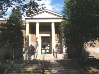
Lawndale School, October 2010
Street map of Philadelphia and surrounding area.png
Red pog.svg
Lawndale
Coordinates: 40°03′00″N75°05′28″W / 40.050°N 75.091°W / 40.050; -75.091
CountryFlag of the United States (23px).png  United States
State Pennsylvania
County Philadelphia County
City Philadelphia
Area code(s) 215, 267, and 445

Lawndale is a neighborhood in Northeast Philadelphia, Pennsylvania, United States. It is located near Rising Sun and Oxford avenues and is south of Cottman Avenue. [1]

Despite the city's notation on the link below, Lawndale originally was named back in the 1880s - The name can be found on City Maps and Reading Railroad Maps dating back to the late 19th century. Prior to that, the community was referred to as Marburg, with its central "business area" around the Kensington & Oxford Turnpike/Second Street Pike (Rising Sun Ave) and Benner, Colgate, and Comly streets. Included in this "industrial" area were the Marburg Bottling Company and a slaughter house, among other businesses. Its more residential end was near the current intersection of Rising Sun Avenue and Levick Street. Levick Street is home to many of the oldest nonfarming homes in the community, many of which were built out of wood. The oldest building still standing in the original community is what is now the Campbell's Funeral Home, which was at one time Paul Mahle's General store in addition to being a farm house. Several older stone homes surround this property and were all part of the Hellerman farm complex. The Hellerman Farms (multiple) owned the most property in this area when it was part of Oxford Township prior to the turn of the 20th century. Much of it was bought up by the Wentz Family of Olney after the 1854 consolidation act. Other land owners included the Fords, the Drakes, the Wolfs, the Brous, the Passmores, the Fesmiers, the Gillhams, the Atwoods, the Unruhs, the Woodfalls, and the Pierce Families.

The name Lawndale can be traced on paper back to when the Philadelphia, Newtown & New York Railroad built its line through the area. One of the first stations listed north of Olney was Lawndale. It was opened in the 1890s and later closed, only to be reopened in the early teens of the new century to accommodate the growing community. The railroad was taken over by the Philadelphia & Reading by then and a small room was leased from a gentleman who lived at the bottom of Robbins Street, whose home faced the railroad. This temporary arrangement lasted for well over 30 years, until the owner died and the railroad was forced to build a small shelter. The Lawndale Station has seen many reincarnations over the years and is still in daily use by SEPTA with the stopping of 45 scheduled passenger trains a day and over 350 round trip fares a day. The physical location of the Lawndale Station property is actually in Montgomery County/Cheltenham Township, while nearby Cheltenham Station (which primarily serves the North end of Lawndale in addition to some residents from Cheltenham, PA. and seeing an additional 400 round trip fares a day) is actually located in Philadelphia County.

Lawndale is home to many diverse residential buildings. There are blocks of row houses, mixed in with singles, twins and even large estate type homes. Most of the community was built in three stages: pre-1920s, 1920–1930 and 1950–1960. Fewer than 40 homes have been built since the 1970s. This mix of housing has kept the area as one of the more desirable places to live in Philadelphia, and is often a secret to many. People are always surprised at the diversity of the housing stock.

The community is home to many Protestant churches, no less than 12 actually, with the oldest being the Trinity Oxford Church which traces its beginnings in the community back to 1698, when the area was part of Oxford Township. Church records confirm the issue of when the community was named; they record the Lawndale name as far back as the late 19th century.

The area is served by two Catholic parishes and one Catholic School: St. William's Parish at Rising Sun and Devereaux Ave. and Presentation BVM Parish at Martins Mill/Old Soldiers Road and Hasbrook Ave in nearby Cheltenham Township with a combined Catholic Population of about 9,000 people, or 3,000 families. Only Presentation BVM School Remains, as St. William School was closed in 2012 due to low enrollment. There was a public school also located within, Lawndale Elementary, but this school was closed some time in the 1980s and sold to the Cedar Grove Church (Rising Sun and Tabor) which has operated it successfully as the Cedar Grove Christian Academy. The former Lawndale School was added to the National Register of Historic Places in 1988. [2] Combined enrollment of the two schools is just over 800 students.

There are no public schools that officially serve the community of Lawndale. The nearest public grade school is Ben Franklin Elementary in Crescentville, which has just over 1100 students and Creighton Elementary, also in Crescenville, with over 800 students. Local high schools are Northeast in Rhawnhurst and Samuel Fels High School in Oxford Circle/Summerdale. Catholic high school students have several options, but the closest and most popular local school was Cardinal Dougherty in Olney, until its closure in 2009.

The Lawncrest Recreation Center serves both the Lawndale and Crescentville communities, as does the Lawncrest Library and Engine 64 Fire House. All are located on Rising Sun Ave between Lardner and Comly streets.

There is a main business district that stretches from Robbins to Longshore Avenue and is home to well over 200 stores of various degrees. With the boundaries of Lawndale, which are Comly Street to the South, SEPTA/CSX Transportation to the West, Longshore/Tyson Ave to the North and Pennway Ave to the East there are well over 500 businesses. One of the Largest employers in the area is the Naval Supply Depot which employs over 5,000 civilian and military workers.

Related Research Articles

<span class="mw-page-title-main">Nether Providence Township, Pennsylvania</span> Township in Pennsylvania, United States

Nether Providence Township is a first class township in Delaware County, Pennsylvania, United States. Many residents refer to the township by the name of its largest community, Wallingford, because the Wallingford postal code is used for most of the township. The population of the township was 13,706 at the 2010 census.

<span class="mw-page-title-main">Fox Chase, Philadelphia</span> Neighborhood of Philadelphia in Philadelphia, Pennsylvania

Fox Chase is a neighborhood in the lower Northeast section of Philadelphia, Pennsylvania, United States.

Lawncrest is a neighborhood in the "Near" (lower) Northeast Philadelphia, Pennsylvania. The name is an amalgam of Lawndale and Crescentville, the two primary communities that make up the neighborhood. The Philadelphia Inquirer does not consider Lawncrest to be a neighborhood.

<span class="mw-page-title-main">Olney, Philadelphia</span> Neighborhood of Philadelphia in Pennsylvania, United States

Olney is a neighborhood in the North Philadelphia section of Philadelphia. It is roughly bounded by Roosevelt Boulevard to the south, Tacony Creek to the east, Godfrey Avenue to the north, and the railroad right-of-way west of 7th Street to the west.

<span class="mw-page-title-main">West Oak Lane, Philadelphia</span> Neighborhood of Philadelphia in Pennsylvania, United States

West Oak Lane is a neighborhood in Northwest Philadelphia, Pennsylvania, United States. The neighborhood was developed primarily between the early 1920s and late 1930s, with the areas near to Cedarbrook constructed after World War II. At the northeast corner of Limekiln Pike and Washington Lane was the site of the Cedar Park Inn, a historic tavern built in the early 19th century, which was torn down sometime after 1931 as the neighborhood was being fully developed.

<span class="mw-page-title-main">Bustleton, Philadelphia</span> Neighborhood of Philadelphia in Philadelphia County, Pennsylvania, United States

The Bustleton section of Northeast Philadelphia, United States is located in the Far Northeast, north of Rhawnhurst and Fox Chase and south of Somerton; sitting between Roosevelt Boulevard to the east, the city boundary to the west, Red Lion Road to the north, and Pennypack Park to the south, it is centered at the intersection of Grant Avenue and Bustleton Avenue (PA-532) and is completely included in the 19115 postal ZIP code.

<span class="mw-page-title-main">Frankford Creek</span> River in Pennsylvania, United States

Frankford Creek is a minor tributary of the Delaware River in southeast Pennsylvania. It derived its name from today's Frankford, Philadelphia neighborhood.

<span class="mw-page-title-main">Logan, Philadelphia</span> Neighborhood of Philadelphia in Pennsylvania, United States

Logan is a neighborhood in the upper North Philadelphia section of the city of Philadelphia, in the U.S. state of Pennsylvania. The majority of the neighborhood falls within the 19141 zip code, but some of it falls within 19140. The neighborhood is sometimes confused with the Olney neighborhood of Philadelphia. Olney Avenue extends from both the Olney and Logan neighborhoods of the city. The Olney Transportation Center is located in Logan.

<span class="mw-page-title-main">Feltonville, Philadelphia</span> Neighborhood of Philadelphia in Pennsylvania, United States

Feltonville is a working-class neighborhood in North Philadelphia, Pennsylvania, United States. It is located east of Logan and Hunting Park, west of Lawncrest and Juniata, south of Olney, and north of Fairhill and Harrowgate. Feltonville is bounded by Erie Avenue to the south, Front Street to the west, Roosevelt Boulevard to the north, Tacony Creek to the northeast, and G Street to the east.

<span class="mw-page-title-main">Oxford Circle, Philadelphia</span> Neighborhood of Philadelphia in Philadelphia County, Pennsylvania, United States

Oxford Circle is a neighborhood in the lower Northeast section of Philadelphia, Pennsylvania, United States. Its namesake is the much used traffic circle at Roosevelt Boulevard and Oxford Avenue. The Oxford Circle neighborhood has traditionally included the areas up to Rhawnhurst and Mayfair but does not really have a fixed boundary, other than in publications about Philadelphia which are of a public relations or informational nature.

<span class="mw-page-title-main">Pennsylvania Route 232</span> State highway in Pennsylvania, US

Pennsylvania Route 232 (PA 232) is a 25.2-mile-long (40.6 km) state highway located in southeastern Pennsylvania. The southern terminus of the route is at U.S. Route 1 (US 1)/US 13 at the Oxford Circle in Philadelphia. The northern terminus is at PA 32 in the borough of New Hope, Bucks County, on the banks of the Delaware River. The route passes through the urban areas of Northeast Philadelphia as Oxford Avenue, serving the Lawncrest, Burholme, and Fox Chase neighborhoods. Upon entering Montgomery County, PA 232 becomes Huntingdon Pike and through suburban areas, serving the communities of Rockledge, Huntingdon Valley, and Bryn Athyn. The route passes through more suburban development in Bucks County as Second Street Pike, running through Southampton and Richboro. In Wrightstown Township, PA 232 enters rural areas and becomes Windy Bush Road as it heads north to New Hope.

<span class="mw-page-title-main">Pennsylvania Route 73</span> State highway in Pennsylvania, US

Pennsylvania Route 73 (PA 73) is a 62.32-mile (100.29 km) long east–west state highway in southeastern Pennsylvania. It runs from PA 61 near Leesport southeast to the New Jersey state line on the Tacony–Palmyra Bridge over the Delaware River in Philadelphia, where the road continues south as New Jersey Route 73. The route passes through rural areas of Berks County, crossing U.S. Route 222 (US 222) in Maiden Creek before heading southeast through Oley and Boyertown. PA 73 continues into Montgomery County and intersects PA 100 in Gilbertsville and PA 29 in Schwenksville before it heads into the northwest suburbs of Philadelphia. The route passes through Skippack and intersects US 202 in Center Square, PA 309 in Springfield Township, and PA 611 near Jenkintown. PA 73 continues through Northeast Philadelphia on Cottman Avenue, crossing US 1 and US 13 before coming to an interchange with Interstate 95 (I-95) near the Tacony–Palmyra Bridge.

<span class="mw-page-title-main">U.S. Route 1 in Pennsylvania</span> Highway in Pennsylvania

U.S. Route 1 (US 1) is a major north–south U.S. Route, extending from Key West, Florida, in the south to Fort Kent, Maine, at the Canada–United States border in the north. In the U.S. state of Pennsylvania, US 1 runs for 81 miles (130 km) from the Maryland state line near Nottingham northeast to the New Jersey state line at the Delaware River in Morrisville, through the southeastern portion of the state. The route runs southwest to northeast and serves as a major arterial road through the city of Philadelphia and for many of the suburbs in the Delaware Valley metropolitan area. South of Philadelphia, the road mostly follows the alignment of the Baltimore Pike. Within Philadelphia, it mostly follows Roosevelt Boulevard. North of Philadelphia, US 1 parallels the route of the Lincoln Highway. Several portions of US 1 in Pennsylvania are freeways, including from near the Maryland state line to Kennett Square, the bypass of Media, the concurrency with Interstate 76 and the Roosevelt Expressway in Philadelphia, and between Bensalem Township and the New Jersey state line.

<span class="mw-page-title-main">U.S. Route 13 in Pennsylvania</span> Highway in Pennsylvania

U.S. Route 13 (US 13) is a United States Numbered Highway running from Fayetteville, North Carolina, north to Morrisville, Pennsylvania. The route runs for 49.359 miles (79.436 km) through the Delaware Valley in the U.S. state of Pennsylvania. The route enters the state from Delaware in Marcus Hook, Delaware County. It continues northeast through Delaware County, passing through the city of Chester before heading through suburban areas along Chester Pike to Darby. US 13 enters the city of Philadelphia on Baltimore Avenue and runs through West Philadelphia to University City, where it turns north along several city streets before heading east across the Schuylkill River along Girard Avenue. The route turns north and heads to North Philadelphia, where it runs northeast along Hunting Park Avenue. US 13 becomes concurrent with US 1 on Roosevelt Boulevard, continuing into Northeast Philadelphia. US 13 splits southeast on a one-way pair of streets before heading northeast out of the city on Frankford Avenue. The route continues into Bucks County as Bristol Pike, heading northeast to Bristol, where it turns into a divided highway. US 13 becomes a freeway in Tullytown and continues north to its terminus at US 1 in Falls Township, near Morrisville. US 13 roughly parallels Interstate 95 (I-95) through its course in Pennsylvania.

<span class="mw-page-title-main">St. William Parish (Lawncrest)</span>

St. William Parish is a Catholic church founded in January 1920 in the Philadelphia Pennsylvania, neighborhood of Lawncrest. The parish originally served 70 households. The Parish elementary school was opened in 1924.

<span class="mw-page-title-main">Crescentville, Philadelphia</span> Neighborhood of Philadelphia in Pennsylvania, United States

Crescentville is a neighborhood in Northeast Philadelphia, United States. It is located in the vicinity of Adams, Rising Sun, and Tabor Avenues. The name Crescentville is thought to be derived from the Crescentville Rope Factory that once stood along the Tookany Creek watershed.

<span class="mw-page-title-main">SEPTA Route 6</span>

SEPTA's Trolley Route 6, also known as the Ogontz Avenue Line is a former streetcar line and current bus route, operated by SEPTA in Philadelphia, Pennsylvania.

Cheltenham Avenue is a major east-west road in Philadelphia and its suburbs. It is served by SEPTA bus routes, trolleys, regional rail, and subway. Cheltenham Avenue is an unsigned quadrant route in Montgomery County. It serves as the border between Springfield and Cheltenham townships. A section of the road along the Philadelphia border with Cheltenham Township is part of PA Route 309.

<span class="mw-page-title-main">Cheltenham Township, Pennsylvania</span> Place in Pennsylvania, United States

Cheltenham Township is a home rule municipality and Township of the First Class located in the southeast corner of Montgomery County, Pennsylvania, United States. It borders Philadelphia to the south and east, Abington Township and Jenkintown to the north, and Springfield Township to the west.

References

  1. "Philadelphia Neighborhoods". Phila.gov. 1998-05-20. Retrieved 2010-07-05.
  2. "National Register Information System". National Register of Historic Places . National Park Service. July 9, 2010.