
Bala Cynwyd is a community in Lower Merion Township, Pennsylvania, United States. It is located on the Philadelphia Main Line in Southeastern Pennsylvania and borders the western edge of Philadelphia at U.S. Route 1. The present-day community was originally two separate towns, Bala and Cynwyd, but was united as a singular community largely because the U.S. Post Office, the Bala Cynwyd branch, served both towns using ZIP Code 19004. The community was long known as hyphenated Bala-Cynwyd. Bala and Cynwyd are currently served by separate stations on SEPTA's Cynwyd Line of Regional Rail.

Wynnefield is a diverse middle-class neighborhood in West Philadelphia. Its borders are 53rd Street at Jefferson to the south, Philadelphia's Fairmount Park to the east, City Avenue to the north and the Amtrak Philadelphia Main Line tracks to the west.

University City is the easternmost portion of West Philadelphia, encompassing several Philadelphia universities. It is situated directly across the Schuylkill River from Center City.

Northern Liberties is a neighborhood in Philadelphia, Pennsylvania, United States. Prior to its incorporation into Philadelphia in 1854, it was among the top 10 largest cities in the U.S. in every census from 1790 to 1850.

Overbrook is an historic neighborhood that is located in the Commonwealth of Pennsylvania, United States. It is situated northwest of West Philadelphia, Philadelphia.

West Philadelphia, nicknamed West Philly, is a section of the city of Philadelphia. Alhough there are no officially defined boundaries, it is generally considered to reach from the western shore of the Schuylkill River, to City Avenue to the northwest, Cobbs Creek to the southwest, and the SEPTA Media/Wawa Line to the south. An alternate definition includes all city land west of the Schuylkill; this would also include Southwest Philadelphia and its neighborhoods. The eastern side of West Philadelphia is also known as University City.
Lawncrest is a neighborhood in the "Near" (lower) Northeast Philadelphia, Pennsylvania. The name is an amalgam of Lawndale and Crescentville, the two primary communities that make up the neighborhood. The Philadelphia Inquirer does not consider Lawncrest to be a neighborhood.

Center City includes the central business district and central neighborhoods of Philadelphia. It comprises the area that made up the City of Philadelphia prior to the Act of Consolidation, 1854, which extended the city borders to be coterminous with Philadelphia County.

Kensington, colloquially known locally as “Kenzo,” is a neighborhood in Philadelphia that belongs to or divides Lower Northeast and North Philadelphia. As with all neighborhoods in the city, the lack of any official designation means the boundaries of the area vary between sources over time and are disputed among locals. Kensington, as most long-term residents view it, refers generally to the area consisting of Kensington, East, or Lower Kensington, West Kensington, and Harrowgate. The adjacent Fairhill and Norris Square neighborhoods are more separate but may be included in Kensington; Fishtown and South (Olde) Kensington were previously included but have developed new identities with gentrification. The most conservative boundaries of the neighborhood, shown in the map below, are Front Street and 5th Street to the west, the Amtrak train tracks to the North, Trenton Avenue, the Trenton Avenue train tracks, and Frankford Avenue to the east, and Cecil B. Moore Avenue to the south.
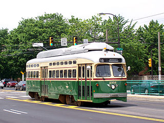
Route 15, the Girard Avenue Line, is a trolley line operated by the Southeastern Pennsylvania Transportation Authority (SEPTA) along Girard Avenue through North and West Philadelphia, Pennsylvania, United States. As of 2007, it is the only surface trolley line in the City Transit Division that is not part of the Subway–Surface Trolley Lines. SEPTA PCC II vehicles are used on the line.

Point Breeze is a multicultural neighborhood in South Philadelphia in Philadelphia, Pennsylvania, United States. It is bounded by 25th Street to the west, Washington Avenue to the north, 18th Street to the east, and Moore Street to the south. Graduate Hospital lies to its north, and Newbold lies to its east. Point Breeze is separated from Grays Ferry to the west by a CSX railway viaduct over 25th Street.

Bridesburg is the northernmost neighborhood in the River Wards section of Philadelphia, Pennsylvania, United States. Bridesburg is an historically German and Irish community, with a significant community of Polish immigrants who arrived mostly in the early- to mid-twentieth century. The community is home to two Catholic churches: All Saints Church, designed by Edwin Forrest Durang, built in 1889; and Saint John Cantius Church, built in 1898 in Polish Cathedral style.

Route 10, also known as the Lancaster Avenue Line, is a trolley line operated by the Southeastern Pennsylvania Transportation Authority (SEPTA) that connects the 13th Street station in Center City Philadelphia, Pennsylvania, to the 63rd Street–Malvern Avenue station in the Overbrook section of West Philadelphia. It is one out of five lines that is part of the SEPTA's subway–surface trolley system and is 11.6 mi (18.7 km) long. It is the least used subway-surface trolley line, but unlike Route 11, the most used subway-surface trolley line, it has overnight service.
Logan is a neighborhood in the upper North Philadelphia section of the city of Philadelphia, in the U.S. state of Pennsylvania. The majority of the neighborhood falls within the 19141 zip code, but some of it falls within 19140. The neighborhood is sometimes confused with the Olney neighborhood of Philadelphia. Olney Avenue extends from both the Olney and Logan neighborhoods of the city. The Olney Transportation Center is located in Logan.

Dunlap is a small neighborhood in the West Philadelphia section of Philadelphia, Pennsylvania, United States. The neighborhood lies between Haverford Avenue and Market Street and stretches from 46th to 52nd streets. Dunlap is squeezed between the neighborhoods of Mill Creek and Haddington and situated just north of Walnut Hill. The neighborhood is named after the former historic Thomas Dunlap School that was restored into senior homes in 1991. Dunlap is located in the 19139 ZIP Code, and is situated in the Philadelphia Police Department's 19th police district, which encompasses a large portion of West Philadelphia.

Spring Garden is a neighborhood in central Philadelphia, Pennsylvania, United States, bordering Center City on the north. Spring Garden is a neighborhood that combines diverse residential neighborhoods and significant cultural attractions. The residential areas on the north side of the neighborhood are composed mostly of brick and brownstone three-story townhouses built during the mid-to-late 19th century. The houses include townhouses in the Italianate style, Second Empire, Queen Anne, and Venetian Gothic. Many streets include "terraced" set ups, which include a small gardened plot, often raised, in front of the house. The residential areas to the south are dominated by taller, multi-family buildings built during the 20th century. The museum area, also to the south of Spring Garden Street, includes the Rodin Museum, the Central Library of Philadelphia, and the Barnes Museum. Before consolidation of Philadelphia, Spring Garden was a district of Philadelphia County.

U.S. Route 13 (US 13) is a United States Numbered Highway running from Fayetteville, North Carolina, north to Morrisville, Pennsylvania. The route runs for 49.359 miles (79.436 km) through the Delaware Valley in the U.S. state of Pennsylvania. The route enters the state from Delaware in Marcus Hook, Delaware County. It continues northeast through Delaware County, passing through the city of Chester before heading through suburban areas along Chester Pike to Darby. US 13 enters the city of Philadelphia on Baltimore Avenue and runs through West Philadelphia to University City, where it turns north along several city streets before heading east across the Schuylkill River along Girard Avenue. The route turns north and heads to North Philadelphia, where it runs northeast along Hunting Park Avenue. US 13 becomes concurrent with US 1 on Roosevelt Boulevard, continuing into Northeast Philadelphia. US 13 splits southeast on a one-way pair of streets before heading northeast out of the city on Frankford Avenue. The route continues into Bucks County as Bristol Pike, heading northeast to Bristol, where it turns into a divided highway. US 13 becomes a freeway in Tullytown and continues north to its terminus at US 1 in Falls Township, near Morrisville. US 13 roughly parallels Interstate 95 (I-95) through its course in Pennsylvania.

Carroll Park is a neighborhood in West Philadelphia, Pennsylvania, United States. Its boundaries are Lansdowne Avenue to the north, West Girard Avenue to the south, North 63rd Street to the west, and North 52nd Street to the east. Along major streets of the neighborhood, the Carroll Park Community Council, Inc. has placed banners that say “Carroll Park: Where our neighbors become friends.” The 10 trolley runs along Lansdowne Avenue and the 15 trolley runs along Girard Avenue. There is a park by the name of Carroll Park between North 59th and North 58th Streets and West Thompson Street and West Girard Avenue. Carroll Park’s residents are primarily working-class and lower-income African-Americans.

Poplar is a neighborhood in Lower North Philadelphia, Pennsylvania, United States. It is located north of Callowhill, between Spring Garden/Fairmount and Northern Liberties, bounded roughly by Girard Avenue to the north, North Broad Street to the west, Spring Garden Street to the south, and 5th Street to the east. The neighborhood is predominantly residential, with commercial frontage on Broad Street and Girard Avenue and some industrial facilities to the west of the railroad tracks along Percy St. and 9th St.

West Passyunk is a neighborhood in South Philadelphia. It is bounded by Mifflin Street to the north, West Passyunk Avenue to the south, South 18th Street to east, and South 25th Street to the west. It is served by the 1st Police District, located at 24th and Wolf Streets.
