Philadelphia, commonly referred to as Philly, is the most populous city in the Commonwealth of Pennsylvania and the second-most populous city in both the Northeast megalopolis and Mid-Atlantic regions after New York City. It is one of the most historically significant cities in the United States and served as the nation's capital until 1800. Philadelphia is the nation's sixth-most populous city with a population of 1,603,797 as of the 2020 census. Since 1854, the city has been coextensive with Philadelphia County, the most populous county in Pennsylvania and the urban core of the Delaware Valley, the nation's seventh-largest and one of the world's largest metropolitan regions with 6.245 million residents. Philadelphia is known for its extensive contributions to American history, especially the American Revolution, and for its contemporary influence in business and industry, culture, sports, and music.

The Centennial International Exhibition of 1876, the first official World's Fair to be held in the United States, was held in Philadelphia, Pennsylvania, from May 10 to November 10, 1876, to celebrate the 100th anniversary of the signing of the Declaration of Independence in Philadelphia. Officially named the International Exhibition of Arts, Manufactures, and Products of the Soil and Mine, it was held in Fairmount Park along the Schuylkill River on fairgrounds designed by Herman J. Schwarzmann. Nearly 10 million visitors attended the exposition, and 37 countries participated in it.

Fairmount Park is the largest municipal park in Philadelphia and the historic name for a group of parks located throughout the city. Fairmount Park consists of two park sections named East Park and West Park, divided by the Schuylkill River, with the two sections together totalling 2,052 acres (830 ha). Management of Fairmount Park and the entire citywide park system is overseen by Philadelphia Parks & Recreation, a city department created in 2010 from the merger of the Fairmount Park Commission and the Department of Recreation.

Fairmount is a neighborhood within Lower North Philadelphia, Pennsylvania, United States. Its boundaries are north of Fairmount Avenue, west of Corinthian Avenue, south of Girard Avenue and east of The Schuylkill River. While this may be the most accurate demarcation, the area's boundaries fluctuate depending how the neighborhood is defined. Several other neighborhoods near Fairmount are sometimes also collectively called Fairmount, including: Spring Garden, Franklintown and Francisville. Fairmount and neighboring Spring Garden are commonly referred to as the "Art Museum Area," for their proximity to and association with the Philadelphia Museum of Art. Fairmount is also the location of the Eastern State Penitentiary.

West Philadelphia, nicknamed West Philly, is a section of the city of Philadelphia. Alhough there are no officially defined boundaries, it is generally considered to reach from the western shore of the Schuylkill River, to City Avenue to the northwest, Cobbs Creek to the southwest, and the SEPTA Media/Wawa Line to the south. An alternate definition includes all city land west of the Schuylkill; this would also include Southwest Philadelphia and its neighborhoods. The eastern side of West Philadelphia is also known as University City.

The Schuylkill Expressway, locally known as "the Schuylkill", is a freeway through southern Montgomery County and the city of Philadelphia. It is the easternmost segment of Interstate 76 (I-76) in the U.S. state of Pennsylvania. It extends from the Valley Forge interchange of the Pennsylvania Turnpike in King of Prussia, paralleling its namesake Schuylkill River for most of the route, southeast to the Walt Whitman Bridge over the Delaware River in South Philadelphia. It serves as the primary corridor into Philadelphia from points west. Maintenance and planning for most of the highway are administered through Pennsylvania Department of Transportation (PennDOT) District 6, with the Delaware River Port Authority (DRPA) maintaining the approach to the Walt Whitman Bridge.

Brewerytown is a neighborhood in the North Philadelphia section of Philadelphia, Pennsylvania, United States. An unofficial region, Brewerytown runs approximately between the Schuylkill River's eastern bank and 25th Street, bounded by Montgomery Avenue to the north and Parrish Street to the south. Brewerytown derived its name from the numerous breweries that were located along the Schuylkill during the late 19th century and early 20th century. It is now primarily a residential neighborhood, with a growing and active commercial sector along Girard Avenue.

Francisville is a neighborhood in North Philadelphia, a section of the city of Philadelphia, Pennsylvania, United States. Its boundaries are Fairmount Avenue to the south, Girard Avenue to the north, Broad Street to the east, and Corinthian Avenue to the west. In 2000, it had a population of about 4,500. It is sometimes considered to be a part of the Fairmount neighborhood, but Fairmount more specifically lies to Francisville's west. To its south is the Spring Garden neighborhood.

Spring Garden is a neighborhood in central Philadelphia, Pennsylvania, United States, bordering Center City on the north. Spring Garden is a neighborhood that combines diverse residential neighborhoods and significant cultural attractions. The residential areas on the north side of the neighborhood are composed mostly of brick and brownstone three-story townhouses built during the mid-to-late 19th century. The houses include townhouses in the Italianate style, Second Empire, Queen Anne, and Venetian Gothic. Many streets include "terraced" set ups, which include a small gardened plot, often raised, in front of the house. The residential areas to the south are dominated by taller, multi-family buildings built during the 20th century. The museum area, also to the south of Spring Garden Street, includes the Rodin Museum, the Central Library of Philadelphia, and the Barnes Museum. Before consolidation of Philadelphia, Spring Garden was a district of Philadelphia County.

Belmont Mansion is a historic mansion located in Fairmount Park in Philadelphia. Built in the early 18th century, the mansion is one of the finest examples of Palladian architecture in the United States. Since 2007, the mansion has hosted the Underground Railroad Museum.

Memorial Hall is a Beaux-Arts style building which is located in the Centennial District of West Fairmount Park, Philadelphia, Pennsylvania. Built as the art gallery for the 1876 Centennial Exposition, it is the only major structure from that exhibition to survive. It subsequently housed the Pennsylvania Museum of Industrial Art.
Route 38 is a bus and former streetcar route operated by the Southeastern Pennsylvania Transportation Authority (SEPTA) in Philadelphia, Pennsylvania, United States.

The Please Touch Museum is a children's museum located in the Centennial District of Philadelphia, Pennsylvania, USA. The museum focuses on teaching children through interactive exhibits and special events, mostly aimed at children seven years old and younger.

The Girard Avenue Bridge is an automobile and trolley bridge in Philadelphia, Pennsylvania, that carries Girard Avenue over the Schuylkill River. It connects the east and west sections of Fairmount Park, and the Brewerytown neighborhood with the Philadelphia Zoo. The current bridge is the third built on the site.

Belmont Village is a middle class neighborhood located in the West Philadelphia section of Philadelphia, Pennsylvania, United States. The zip code is 19131.

Girard Avenue is a major commercial and residential street in Philadelphia, Pennsylvania. For most of its length it runs east–west, but at Frankford Avenue it makes a 135-degree turn north. Parts of the road are signed as U.S. Route 13 and U.S. Route 30.
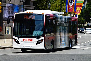
The Philly PHLASH Downtown Loop is a visitor-friendly public transit service in Philadelphia, Pennsylvania, managed by the Independence Visitor Center Corporation (IVCC). PHLASH vehicles are ADA-compliant, temperature-controlled New Flyer MiDi buses. The IVCC contracted Krapf Transit to manage vehicle operations.


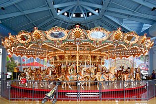 Carousel in the Please Touch Museum
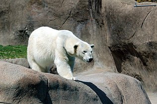 Polar Bear at the Philadelphia Zoo
 Law, Prosperity and Power by Daniel Chester French near the Mann Center
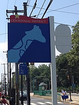 Centennial District signage


