
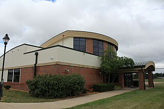
Ohio State University Airport is a public airport six miles (10 km) northwest of downtown Columbus, in Franklin County, Ohio, United States. It is owned and operated by Ohio State University in Columbus. It is also known as the OSU Don Scott Airport, named after Donald E. Scott, an OSU alumnus who died during his training as a pilot in the United Kingdom during World War II. The airport's main entrance is located on Case Road, and is easily accessible from OH-315 and Interstate 270.
Ohio University Airport or Gordon K. Bush Airport, also known as Snyder Field, is a public-use airport located on State Route 32/U.S. 50 in the village of Albany, about ten miles (16 km) southwest of the city of Athens, in Athens County, Ohio, United States.
Portage County Airport, also known as Portage County Regional Airport, is a public use airport in Portage County, Ohio, United States. It is owned by the Portage County Board of Commissioners and located three nautical miles (6 km) north of Ravenna, in Shalersville Township. This airport is included in the National Plan of Integrated Airport Systems for 2011–2015, which categorized it as a general aviation facility.
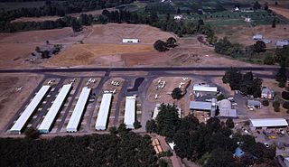
Stark's Twin Oaks Airpark is a privately owned public-use airport located 4 miles (6.4 km) south of the city of Hillsboro in Washington County, Oregon, United States.

James Clements Municipal Airport is a city-owned, public-use airport located three nautical miles (6 km) south of the central business district of Bay City, in Bay County, Michigan, United States. It is included in the Federal Aviation Administration (FAA) National Plan of Integrated Airport Systems for 2017–2021, in which it is categorized as a local general aviation facility. It is also a seaplane base with landing areas on the Saginaw River, adjacent to the airport.

Moraine Airpark is a public-use airport situated in the city of Moraine, Ohio, United States. 4 miles (6.4 km) southwest of the city of Dayton in Montgomery County.
Newark–Heath Airport is a public airport located in Heath, Ohio. It is three miles (4.8 km) southwest of the central business district of Newark, a city in Licking County, Ohio, United States. The airport was opened in 1930 by the city of Newark, and was transferred to the Licking County Regional Airport Authority in 1967. The airport currently has a McDonnell Douglas F-4C Phantom II S.N. 64–0683 on static display.
Madison County Airport is a public airport located 3 miles (4.8 km) north of the central business district of London, a city in Madison County, Ohio, United States. It is owned by the Madison County Airport Authority.
Dowagiac Municipal Airport is a public airport owned and operated by the City of Dowagiac located 1m (1.6 km) northwest of Dowagiac, Michigan, United States. The uncontrolled airport is used for general aviation purposes. It is included in the Federal Aviation Administration (FAA) National Plan of Integrated Airport Systems for 2017–2021, in which it is categorized as a local general aviation facility.
Grand Haven Memorial Airpark is a public airport owned and operated by the City of Grand Haven located 2 miles (3.2 km) southeast of Grand Haven, Michigan. The airport is uncontrolled, and is used for general aviation purposes. It is included in the Federal Aviation Administration (FAA) National Plan of Integrated Airport Systems for 2017–2021, in which it is categorized as a local general aviation facility.
Fairfield County Airport is a public use airport in Fairfield County, Ohio, United States. It is located three nautical miles (6 km) northwest of the central business district of Lancaster, the county seat. The airport is owned by the Fairfield County Commissioners.
Medina Municipal Airport is a public use airport in Medina County, Ohio, United States. It is owned by the City of Medina and is located four nautical miles (7.41 km) east of the city's central business district. According to the FAA's National Plan of Integrated Airport Systems for 2007-2011, it is categorized as a reliever airport.

Grimes Field is a city-owned public-use airport located one nautical mile (1.85 km) north of the central business district of Urbana, a city in Champaign County, Ohio, United States. The airport is named after Warren G. Grimes, a forefather in the field of aviation lighting, and his Grimes Manufacturing Company operated the airport until 1987. It primarily serves general aviation traffic. Although it is owned by the City of Urbana, Grimes Field is self-supporting.
Paul C. Miller–Sparta Airport is a public airport located 3 mi (5 km) southeast of Sparta, Michigan. Established in 1941, the airport is currently owned and operated by the Village of Sparta and is self-supporting, requiring no public funding. It is included in the Federal Aviation Administration (FAA) National Plan of Integrated Airport Systems for 2017–2021, in which it is categorized as a regional general aviation facility.
Galion Municipal Airport is three miles northeast of Galion in Crawford County, Ohio. The FAA's National Plan of Integrated Airport Systems for 2009–2013 classified it as a general aviation airport.

Luce County Airport is a county-owned public-use airport located three miles southeast of the central business district of Newberry, a city in Luce County, Michigan, United States. It is included in the Federal Aviation Administration (FAA) National Plan of Integrated Airport Systems for 2017–2021, in which it is categorized as a basic general aviation facility.
Jack Barstow Airport, also known as Jack Barstow Municipal Airport, is a city-owned, public-use airport located three nautical miles (6 km) northwest of the central business district of Midland, a city in Midland County, Michigan, United States. It is included in the Federal Aviation Administration (FAA) National Plan of Integrated Airport Systems for 2017–2021, in which it is categorized as a local general aviation facility.
Dalton Airport is a privately owned, public use airport located two nautical miles (4 km) east of the central business district of Flushing, in Genesee County, Michigan, United States. It is named after its founder, Edwin P. Dalton, who opened it in 1946 on the former site of the Marsa farm.
Harry Clever Field is a public airport three miles southeast of New Philadelphia, in Tuscarawas County, Ohio. The National Plan of Integrated Airport Systems for 2018 categorized it as a general aviation facility.
Menominee Regional Airport is a public use airport located 1 mile (2 km) northwest of the central business district of Menominee, Michigan, a city in Menominee County, Michigan, United States. It is included in the Federal Aviation Administration (FAA) National Plan of Integrated Airport Systems for 2021–2025, in which it is categorized as a local general aviation facility.
