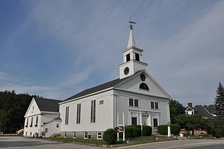
Pelham is a town in Hillsborough County, New Hampshire, United States. The population was 14,222 at the 2020 census, up from 12,897 at the 2010 census.
The Big Beaver Airport, formerly, was a small suburban general aviation airport located at the corners of Big Beaver Road and John R Road in Troy, Michigan.
Hale's Island is a 54-acre (22 ha) island located on the Merrimack River in Haverhill / Bradford, Massachusetts. The property is part of Silsby's farm.

Pawtucket Falls is a waterfall on the Merrimack River at Lowell, Massachusetts. The waterfall and rapids below it drop a total of 32 feet in a little under a mile, and was an important fishing ground for the Pennacook Indians in pre-colonial times.

Coonamessett Airport was an airfield operational in the mid-20th century in Hatchville, Massachusetts. It is now part of the Pheasant Area at the Frances A. Crane Wildlife Management Area.
Trade Wind Airport is an airfield in Oak Bluffs, Massachusetts, located in Dukes County on the Island of Martha's Vineyard.
Camp Framingham is a former Massachusetts National Guard camp that existed in 1873 to 1944 in Framingham, Massachusetts, also called Camp Dalton or Fort Dalton until 1898. The camp was used by all units of the Massachusetts Volunteer Militia as their summer training ground. The camp also contained a state arsenal where weapons and equipment was stored and issued to units. Fort Dalton was a training battery from 1883 to 1898, 138 feet (42 m) long with two 10 in (254 mm) Rodman guns and four siege mortars. Camp Framingham was used as a mobilization station during the Spanish–American War, in June 1916 during the Mexican border call-up and in the summer of 1917 during World War I. Other names for the camp in the Spanish–American War were Camp McGuinness and Camp Dewey. From May 1942 to December 1943, Headquarters, 181st Infantry Regiment was stationed with its companies serving on coast patrol duty for the Eastern Defense Command in New England. In 1948, Camp Framingham was transferred from the Military Division to the Massachusetts State Police. Today, the Massachusetts State Police and the Massachusetts Emergency Management Agency utilize portions of the former camp.

The Mary Ellen Welch Greenway is a rail trail and park in East Boston that is located along the path of a former Conrail line. The greenway connects several significant open space areas in East Boston, including Piers Park, Memorial Stadium, Bremen Street Park, Wood Island Bay Marsh and Belle Isle Marsh. When completed, the line is expected to be 3.3 miles in length.
Bolton Airport was an airfield operational in the mid-20th century in Clinton, Massachusetts.
Acushnet Airport was an airfield operational in the mid-20th century in Acushnet, Massachusetts.
Brockton Airport was an airfield operational in the mid-20th century in Brockton, Massachusetts.
Clark Airport was an airfield operational in the mid-20th century in Hanover, Massachusetts. During the time it was closed during World War II, the Pilgrim Ordnance Works was located to the west of the airport.
Haverhill Dutton Airport was an airfield operational in the mid-20th century in Haverhill, Massachusetts. One of the smallest airports in the continental U.S., the runway was 1,500 feet long, and its width was 30 feet, 15 of which was asphalt and the remaining of dirt. The owner-operator, Howard Dutton, lived with his family on the grounds. Dutton was an accomplished barnstormer in the 1930s and had photographs of his biplane stunts from that era hanging in his home.
Haverhill Riverside Airport & Seaplane Base was an airfield operational in the mid-20th century in Haverhill, Massachusetts. The airport was owned and operated by William "Red" Slavit, who died in 2008. The airport code for Haverhill river side airport was MA04.
Bowles Agawam Airport was an airfield operational in the mid-20th century in Agawam, Massachusetts.
Grafton Airport was a private airfield that was operational during the mid-20th century in Grafton, Massachusetts.
Leicester Airport was an airfield operational in the mid-20th century in Leicester, Massachusetts. It was located adjacent and to the west of the Worcester Regional Airport.
Pine Hill Airport was an airfield operational in the mid-20th century in Lancaster, Massachusetts.
Westboro Airport was an airfield operational in the mid-20th century in Westborough, Massachusetts.

The Middlesex County Training School is a former reform school located in North Chelmsford, Massachusetts. After its closure, its buildings were purchased by the University of Massachusetts Lowell, which utilized its buildings for its College of Education. Today, the school's records are housed in the Massachusetts Archives.


