
Cape Cod Gateway Airport, also known as Boardman/Polando Field and formerly known as Barnstable Municipal Airport, is a public airport located on Cape Cod, one mile (1.6 km) north of the central business district of Hyannis, in Barnstable County, Massachusetts, United States. This airport is publicly owned by Town of Barnstable. It is Cape Cod's major airport as well as an air hub for the Cape and the Islands. The airport is served by scheduled commercial flights as well as charters and general aviation. Barnstable Municipal Airport served as a hub for Nantucket-based commuter airline Island Airlines until its shutdown in 2015.

Provincetown Municipal Airport is a public airport located at the end of Cape Cod, two miles (3 km) northwest of the central business district of Provincetown, in Barnstable County, Massachusetts, United States. This airport is operated by the Town of Provincetown on land leased from the United States National Park Service.

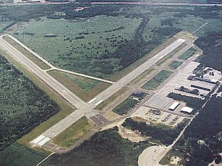
Provo Municipal Airport is a public-use airport two miles [3.2 km] west of Provo, in Utah County, Utah. It is a small regional airport with domestic flights mainly to destinations in the western United States.
Norwood Memorial Airport is a public airport 2 mi east of Norwood, in Norfolk County, Massachusetts, United States. It is home to the offices of prominent local business people and several maintenance facilities.

Westfield-Barnes Regional Airport is a joint civil-military airport in Hampden County, Massachusetts, three miles (6 km) north of Westfield and northwest of Springfield. It was formerly Barnes Municipal Airport; the National Plan of Integrated Airport Systems for 2011–2015 categorized it as a general aviation facility. Westfield-Barnes is one of Massachusetts' largest airports with a strong flight training, general aviation, and military presence. It is also known as Barnes Air National Guard Base.
Lawrence Municipal Airport is two miles east of Lawrence, in Essex County, Massachusetts, United States. It is owned by the City of Lawrence, though it is in North Andover.
Myricks Airport, in Berkley, Massachusetts, is an historic, public airport owned by the Myricks Airfield Foundation. It has one turf runway (9/27), averages 59 flights per week, and has approximately 2 aircraft based on its field.
Cranland Airport, in Hanson, Massachusetts is a public use airport owned by Cranland Inc. It has one runway, averages 102 flights per week, and has approximately 28 aircraft based on its field.

Hopedale Industrial Park Airport, in Hopedale, Massachusetts, is a private airport open to the public. It is owned by the Hopedale Industrial Park. It has one runway and sees very low traffic. Approximately sixteen aircraft are based at Hopedale. At one point, it housed a flight school and offered plane rentals.
Spencer Airport, in Spencer, Massachusetts, is a public airport which was once owned by Gregg E. Andrews. It has one runway, averages 125 flights per week, and has approximately 26 aircraft based on its field. Andrews Aviation, based at the airport provides flight instruction in a vintage Piper J-3 Cub.

Southbridge Municipal Airport is a public airport located two miles (3 km) north of the central business district (CBD) of the Town of Southbridge, a city in Worcester County, Massachusetts, USA. The airport is owned and operated by the Town of Southbridge and overseen by the Southbridge Municipal Airport Commission. It covers 229 acres (93 ha), has a single runway, averages 142 flights per day, and has approximately 30 aircraft based on its field. The airport sustained damage on June 1 from the 2011 New England tornado outbreak.
Turners Falls Airport, also referred to as Turners Falls Municipal Airport, is a town owned, public use airport located three nautical miles (6 km) north of the central business district of Montague, a town in Franklin County, Massachusetts, United States. It is owned by the Town of Montague. It is included in the National Plan of Integrated Airport Systems for 2011–2015, which categorized it as a general aviation facility.

Marshfield Municipal Airport, also known as George Harlow Field, is a public airport located 2 mi (3 km) east of the central business district (CBD) of Marshfield, a town in Plymouth County, Massachusetts, USA. Formerly, it had the ICAO code 3B2.
Gardner Municipal Airport is a public airport located 2 nmi (3.7 km) southwest of the central business district of Gardner, a city in Worcester County, Massachusetts, United States. This airport is owned by the City of Gardner, and is located in the town of Templeton.

Chatham Municipal Airport is a public airport located two miles (3 km) northwest of the central business district of Chatham, a town in Barnstable County, Massachusetts, United States. The airport is owned by the Town of Chatham. It has a full-service FBO and maintenance facility in their main building. The flight school and sightseeing is operated by Cape Aerial Tours. Upstairs, there is also a restaurant and coffee company, Hangar B and B-Side, respectively, serving breakfast and lunch.

Plymouth Municipal Airport is a town-owned, public-use airport located four nautical miles (7 km) southwest of the central business district of Plymouth, a town in Plymouth County, Massachusetts, United States. According to the FAA's National Plan of Integrated Airport Systems for 2009–2013, it is categorized as a general aviation airport. Due to space issues, the airport has 2 gates in Carver, Massachusetts.
Evart Municipal Airport is a public airport located 1 mile (2 km) west of Evart in Osceola County, Michigan, United States. It is included in the Federal Aviation Administration (FAA) National Plan of Integrated Airport Systems for 2017–2021, in which it is categorized as a general aviation facility.

Florence Municipal Airport, is a public airport located in the city of Florence in Lane County, Oregon, United States. It is mostly used for general aviation.
Perry County Municipal Airport is seven miles northeast of Tell City, in Perry County, Indiana. It is owned by the Perry County Airport Authority.
Pekin Municipal Airport is a city-owned public-use airport located four nautical miles south of the central business district of Pekin, a city in Tazewell County, Illinois, United States. It is included in the FAA's National Plan of Integrated Airport Systems for 2011–2015, which categorized it as a general aviation facility.

