Related Research Articles
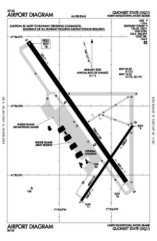
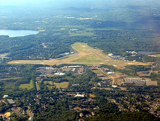
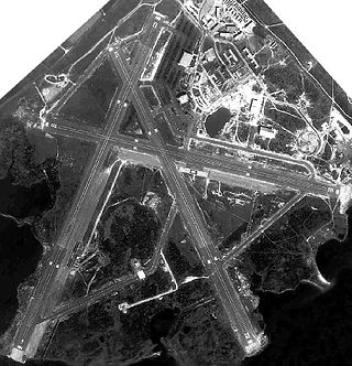
Quonset State Airport is a joint civil-military public airport located on Quonset Point, in northeastern North Kingstown, Rhode Island, United States, adjacent to Narragansett Bay. It is a general aviation airport and there is no scheduled airline service available. It is included in the Federal Aviation Administration (FAA) National Plan of Integrated Airport Systems for 2017–2021, in which it is categorized as a regional general aviation facility.

New Bedford Regional Airport is a Part 139 Commercial-Service Airport, municipally-owned and available for public use. The airport is located three nautical miles northwest of the City of New Bedford, a city in Bristol County, Massachusetts, United States.

Naval Station Norfolk Chambers Field (IATA: NGU, ICAO: KNGU, FAA LID: NGU),or LP-1/Chambers Field, is commonly known simply as, Chambers Field, and is named after Captain Washington Irving Chambers. It is a military airport in Norfolk, Virginia that is a part of Naval Station Norfolk. It supports naval air forces in the United States Fleet Forces Command, those operating in the Atlantic Ocean, Mediterranean Sea, and Indian Ocean. It's important to note that, "Chambers Field" only refers to the geographical area of the airport runway, taxiways, two heliports and six helipads.
Beverly Regional Airport is a city-owned, public-use airport located in Beverly, Danvers and Wenham, Massachusetts, in Essex County, three nautical miles (6 km) northwest of Beverly's central business district.

Plymouth Municipal Airport is a town-owned, public-use airport located four nautical miles (7 km) southwest of the central business district of Plymouth, a town in Plymouth County, Massachusetts, United States. According to the FAA's National Plan of Integrated Airport Systems for 2009–2013, it is categorized as a general aviation airport. Due to space issues, the airport has 2 gates in Carver, Massachusetts.

Davisville, Rhode Island is a village in the town of North Kingstown in the U.S. state of Rhode Island that was formerly the home of the Davisville Naval Construction Battalion Center, which housed the United States Navy's SeaBees.
Naval Outlying Landing Field (NOLF) Imperial Beach is a United States Navy facility for helicopters, situated on 1,204 acres (5 km2) approximately 14 miles (23 km) south of San Diego and within the city limits of Imperial Beach, California. It is known as "The Helicopter Capital of the World".

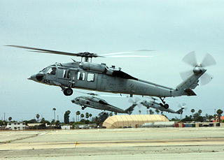
Quonset Point Air National Guard Station is the home base of the Rhode Island Air National Guard 143d Airlift Wing. Naval Air Station (NAS) Quonset Point was a United States Naval Base in Quonset Point, Rhode Island that was deactivated in 1974. Next to NAS Quonset Point was Camp Endicott at Davisville, home of the Naval Construction Battalions known as the Seabees. Quonset Point also gave its name to the Quonset hut, a standardized temporary structure used by the U.S. military starting in World War II. Former US President Richard M. Nixon went through basic naval officer training at Quonset Point in 1942.

Naval Air Station South Weymouth was an operational United States Navy airfield from 1942 to 1997 in South Weymouth, Massachusetts. It was first established as a regular Navy blimp base during World War II. During the postwar era the base became part of the Naval Air Reserve Training Command, hosting a variety of Navy and Marine Corps reserve aircraft squadrons and other types of reserve units. Like most BRAC sites, environmental contamination was detected in 1986, and since 1993 numerous remedies and long term monitoring of ground water are in place. Since 2005, over 600 acres have been transferred to the affected towns for reuse, and in 2011 the Navy signed a $25 million contract to transfer its remaining land.

Naval Air Station Squantum was an active naval aviation facility during 1917 and from 1923 until 1953. The original civilian airfield that preceded it, the Harvard Aviation Field, dates back to 1910. The base was sited on Squantum Point in the city of Quincy, Massachusetts. It also abutted Dorchester Bay, Quincy Bay, and the Neponset River.

Naval Air Station Glynco, Georgia, was an operational naval air station from 1942 to 1974 with an FAA airfield identifier of NEA and an ICAO identifier of KNEA.
Naval Auxiliary Air Station Charlestown is located in Charlestown, Rhode Island, United States. It was a satellite airfield to the nearby Quonset Naval Air Station. It is located within the boundaries of the Ninigret National Wildlife Refuge.

Naval Facility Nantucket Island or simply Naval Facility Nantucket was a shore terminal of the Sound Surveillance System (SOSUS) active from 1955 to 1976. The true function of the system and the shore terminals, in which output of the array at sea was processed and displayed by means of the Low Frequency Analyzer and Recorder (LOFAR), was classified and the term "Naval Facility" was intentionally vague. Its function was described as oceanographic research.
Naval Auxiliary Air Facility Hyannis was a United States Navy facility located in Hyannis, Massachusetts operational from 1942 to 1945. It existed as an auxiliary air facility of Naval Air Station Quonset Point.

Holtville Airport is a county-owned, public-use airport located five nautical miles (9 km) northeast of the central business district of Holtville, a city in Imperial County, California, United States. Holtville was a U.S. Navy airfield during World War II.
Naval Auxiliary Air Station Martha's Vineyard was a United States Navy facility located in Edgartown and West Tisbury, Massachusetts operational from 1943 to 1946. It existed as an auxiliary air facility of Naval Air Station Quonset Point.
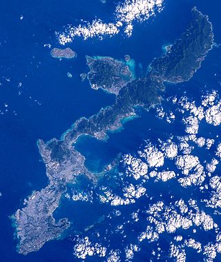
Naval Base Okinawa, now Naval Facility Okinawa, was and is a number of bases built after the Battle of Okinawa by United States Navy on the Okinawa Island of Japan. The naval bases were built to support the landings on Okinawa on April 1, 1945, and the troops fighting on Okinawa. The Navy repaired and did expansion of the airfields on Okinawa. United States Navy Seabee built or repaired the facilities on the island. The bases on Okinawa put the United States Armed Forces only 350 miles from Japan's home islands. Most facilities closed after the war, but some are still in use today in all branches of the United States Armed Forces.
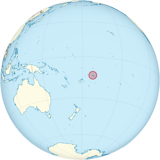
Naval Base Upolu was a naval base built by the United States Navy in 1942 to support the World War II effort. The base was located on Upolu Island, Samoa in the Western Pacific Ocean, part of the Samoan Islands's Naval Base Samoa. After the surprise attack on Naval Station Pearl Harbor on December 7, 1941, the US Navy was in need of setting up more advance bases in the Pacific Ocean. At Naval Base Upolu the Navy built a sea port, an airbase and a seaplane base.
References
- 1 2 "Massachusetts Naval Air Bases, Coast Guard Bases, Military & Auxiliary Air Fields 1923-1945". Massachusetts Aviation Historical Society. 2011. Retrieved 26 June 2014.
- ↑ "Early Aviation on Nantucket". Nantuckeet Historical Association. Retrieved 15 July 2014.
- 1 2 3 4 5 "Archives Search Report Conclusions and Recommendations for Nantucket Municipal Airport former Naval Auxiliary Air Facility Nantucket" (PDF). United States Army Ammunition Center. Archived from the original (PDF) on 7 March 2004. Retrieved 15 July 2014.