Glacier Park International Airport is in Flathead County, Montana, United States, six miles northeast of Kalispell. The airport is owned and operated by the Flathead Municipal Airport Authority, a public agency created by the county in 1974.

Westfield-Barnes Regional Airport is a joint civil-military airport in Hampden County, Massachusetts, three miles (6 km) north of Westfield and northwest of Springfield. It was formerly Barnes Municipal Airport; the National Plan of Integrated Airport Systems for 2011–2015 categorized it as a general aviation facility. Westfield-Barnes is one of Massachusetts' largest airports with a strong flight training, general aviation, and military presence. It is also known as Barnes Air National Guard Base.

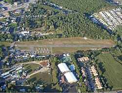
Cuyahoga County Airport, also known as Robert D. Shea Field, is a public use airport in northeastern Cuyahoga County, Ohio, United States. Owned and operated by Cuyahoga County since 1946, it also serves Lake County and Geauga County. The airport is located 10 nautical miles east of downtown Cleveland and sits on the border of three cities: Highland Heights, Richmond Heights and Willoughby Hills. It is included in the National Plan of Integrated Airport Systems for 2011–2015, which categorized it as a general aviation reliever airport for Cleveland Hopkins International Airport.
Pittsfield Municipal Airport is two miles west of Pittsfield, in Berkshire County, Massachusetts. The National Plan of Integrated Airport Systems for 2011–2015 categorized it as a general aviation facility.
Lawrence Municipal Airport is two miles east of Lawrence, in Essex County, Massachusetts, United States. It is owned by the City of Lawrence, though it is in North Andover.

Hopedale Industrial Park Airport, in Hopedale, Massachusetts, is a private airport open to the public. It is owned by the Hopedale Industrial Park. It has one runway and sees very low traffic. Approximately sixteen aircraft are based at Hopedale. At one point, it housed a flight school and offered plane rentals.
Airlake Airport is a public use airport in Dakota County, Minnesota, United States. Owned by the Metropolitan Airports Commission, It is approximately 20 miles (32 km) south of both downtown Minneapolis and downtown St. Paul The airport is located near the Twin Cities suburbs of Lakeville and Farmington.
Beaver Island Airport is a public use airport located on Beaver Island in Charlevoix County, Michigan, United States. It is owned by St. James Township and Peaine Township. It is included in the Federal Aviation Administration (FAA) National Plan of Integrated Airport Systems for 2017–2021, in which it is categorized as a local general aviation facility.

Auburn Municipal Airport is a public airport located three miles (5 km) north of Auburn, serving Placer County, California, United States. It is mostly used for general aviation.

St. Louis Downtown Airport is a public-use airport located in Greater St. Louis, one mile (2 km) east of the central business district of Cahokia Heights, in St. Clair County, Illinois, United States. It is owned by the Bi-State Development Agency. The airport is located less than 3 miles from the Gateway Arch riverfront in St. Louis and is used by many business aircraft visiting the St. Louis region. Airport services include one full-service 24-hour fixed-base operator, an instrument landing system, an FAA air traffic control tower, and its own dedicated Index B aircraft rescue and firefighting (ARFF) service. It is utilized mainly by Saint Louis University's Parks College of Engineering, Aviation and Technology for training purposes, as well as the St. Louis Cardinals for charter flights to away games.

Chicago/Aurora Municipal Airport is a public airport opened in April 1966, located in the village of Sugar Grove, Illinois, United States, 8 miles (13 km) west of the city of Aurora, both in Kane County. The airport is owned and operated by the City of Aurora. It is 50 miles (80 km) west of Chicago and is designated as a reliever airport for Chicago's O'Hare and Midway airports.
Plant City Airport is a public-use airport located two nautical miles (4 km) southwest of the central business district of Plant City in Hillsborough County, Florida, United States. The airport is publicly owned by the Hillsborough County Aviation Authority, which also operates Tampa International Airport. It was formerly known as Plant City Municipal Airport. It supports a 400-acre (1.6 km2) industrial park located about one mile (1.6 km) east of the airport.

Bartow Executive Airport is a public airport four miles (6 km) northeast of Bartow, in Polk County, Florida. It is owned by the Bartow Airport Authority.

Clark Regional Airport is a public use airport in Clark County, Indiana, United States. The airport is owned by the South Central Regional Airport Authority. It is located five nautical miles (9 km) north of the central business district of Jeffersonville, Indiana, in the town of Sellersburg. It is also seven miles (11 km) north of Louisville.
Heritage Field is a public use airport in Montgomery County, Pennsylvania, United States. It is located three nautical miles (6 km) east of Pottstown, in Limerick Township. The airport is privately owned by Limerick Aviation LP.
Herlong Recreational Airport, also known as Herlong Field, then Herlong Airport, is a public airport located eight nautical miles (13 km) southwest of the central business district of Jacksonville, a city in Duval County, Florida, United States.

Donaldson Field Airport is a public airport six miles (10 km) south of the central business district of Greenville, a city in Greenville County, South Carolina, United States. It is located at the Donaldson Center Industrial Air Park and is owned by the City and County of Greenville.
Anderson Municipal Airport is a public use airport three miles east of Anderson in Madison County, Indiana. The National Plan of Integrated Airport Systems for 2011–2015 categorized it as a general aviation facility. The airport currently has no scheduled air service.
Baraboo–Wisconsin Dells Airport is a public use airport located three nautical miles (6 km) northwest of the central business district of Baraboo, in Sauk County, Wisconsin, United States. The airport is located between Baraboo and Lake Delton, Wisconsin, on US 12, and is adjacent to the Ho-Chunk Casino.
Olive Branch Airport is owned by the City of Olive Branch. It is a public use airport in De Soto County, Mississippi, United States. It is located three nautical miles (6 km) northeast of the central business district of Olive Branch, Mississippi. This airport was included in the National Plan of Integrated Airport Systems for 2021–2025, which categorized it as a general aviation reliever airport.