
Sonoma County is a county in the U.S. state of California. As of the 2010 United States Census, its population was 483,878. Its county seat and largest city is Santa Rosa. It is to the north of Marin County and the south of Mendocino County. It is west of Napa County and Lake County.

Coast Miwok are an indigenous people that was the second-largest group of Miwok people. Coast Miwok inhabited the general area of modern Marin County and southern Sonoma County in Northern California, from the Golden Gate north to Duncans Point and eastward to Sonoma Creek. Coast Miwok included the Bodega Bay Miwok, from authenticated Miwok villages around Bodega Bay, and the Marin Miwok.
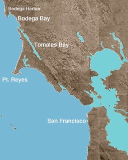
Bodega Bay is a shallow, rocky inlet of the Pacific Ocean on the coast of northern California in the United States. It is approximately 5 mi (8 km) across and is located approximately 40 mi (60 km) northwest of San Francisco and 20 mi (32 km) west of Santa Rosa. The bay straddles the boundary between Sonoma County to the north and Marin County to the south. The bay is a marine habitat used for navigation, recreation, and commercial and sport fishing.
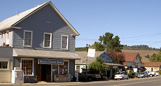
Bodega is an unincorporated community and census-designated place (CDP) in Sonoma County in the U.S. state of California. The town had a population of 220 as of the 2010 Census.

Duncans Mills is an unincorporated community located in Sonoma County, California.
Valley Ford is an unincorporated community and census-designated place (CDP) in western Sonoma County, California, United States. It is located on State Route 1 in an area of rolling hills about 75 minutes north of San Francisco by automobile. Like all of Sonoma County, Valley Ford is included in both the San Francisco Bay Area and the Redwood Empire.

The Northwestern Pacific Railroad is a railroad covering the 62 mi (100 km) stretch between Schellville and Windsor with freight and Sonoma–Marin Area Rail Transit (SMART) commuter trains. Formerly, it was a regional railroad that served the entire North Coast of California, with a main line running 271 miles (436 km) from Schellville to Eureka, along with an additional portion of the line running from the Ignacio Wye to the edge of San Rafael. The portion of the NWP main line between the Ignacio Wye in Marin County and the depot in Healdsburg is owned by SMART. The Schellville–Ignacio and Healdsburg–Eureka portions are owned by the North Coast Railroad Authority (NCRA). Private contractor NWPco operates freight service under NCRA lease. California's 2018 Great Redwood Trail Act repurposes the abandoned railroad right-of-way from Eureka to the San Francisco Bay in Marin County for future use as the "Great Redwood Trail" rail-trail.
Kenwood, California is an unincorporated community and census-designated place (CDP) in Sonoma County, California, United States, located on Sonoma Highway between the cities of Santa Rosa and Sonoma. It lies east of Sonoma Creek in the upper part of Sonoma Valley, a region sometimes called the Valley of the Moon. Bennett Mountain lies west of the town, and Sugarloaf Ridge to the northeast. The population was 1,028 at the 2010 census.

Jasper O'Farrell (1817–1875) was an Irish-American politician who served as the first surveyor for San Francisco. He designed the "grand promenade" that became today's Market Street. O'Farrell Street in San Francisco is named after him.

Rancho Petaluma Adobe is a historic ranch house in Sonoma County, California. It was built from adobe bricks in 1836 by order of Mariano Guadalupe Vallejo. It was the largest privately owned adobe structure built in California and is the largest example of the Monterey Colonial style of architecture in the United States. A section of the former ranch has been preserved by the Petaluma Adobe State Historic Park and it is both a California Historic Landmark and a National Historic Landmark. The Rancho Petaluma Adobe State Historic Park is located on Adobe Road on the east side of the present-day town of Petaluma, California.

Americano Creek is a 7.5-mile (12 km) long westward-flowing stream in the California counties of Sonoma and Marin. It flows into the Estero Americano, a 9.2 mi (15 km) long estuary, and thence to the Pacific Ocean. This article covers both watercourses.
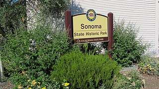
Sonoma State Historic Park is a California State Park located in the center of Sonoma, California. The park consists of six sites: the Mission San Francisco Solano, the Sonoma Barracks, the Blue Wing Inn, La Casa Grande, Lachryma Montis, and the Toscano Hotel.
Rancho Estero Americano was a 8,849-acre (35.81 km2) Mexican land grant in present-day Sonoma County, California given in 1839 by Governor Pro-tem Manuel Jimeno to Edward Manuel McIntosh. The rancho takes its name from Estero Americano.
Rancho Cañada de Jonive was a 10,787-acre (43.65 km2) Mexican land grant in present day Sonoma County, California given in 1845 by Governor Pío Pico to James Black. The grant encompassed the town of Freestone.
Rancho Cañada de Pogolimi was a 8,781.81-acre (35.5387 km2) Mexican land grant in present-day Sonoma County, California given in 1844 by Governor Manuel Micheltorena to María Antonia Cazares, widow of James Dawson. The grant encompasses present-day Bloomfield.

Rancho Bodega was a 35,487-acre (143.61 km2) Mexican land grant in present day Sonoma County, California given in 1844 by Governor Manuel Micheltorena to Stephen Smith. Bodega takes its name from the Peruvian explorer Juan Francisco de la Bodega y Quadra who discovered Bodega Bay in 1775. The grant extended along the Pacific coast from the Russian River on the north to Estero Americano on the south, and included the present-day town of Bodega Bay. Only a small part of Bodega is within the grant.
Rancho El Molino was a 17,892-acre (72.41 km2) Mexican land grant in present-day Sonoma County, California given to John B.R. Cooper by Governor José Figueroa in 1833 and officially confirmed by Governor Nicolás Gutiérrez in 1836. "Molino" means "mill" in Spanish, and the name refers to Cooper's sawmill. The grant extends south from Russian River along Atascadero Creek, and encompasses present-day Forestville.

The Hinds Hotel is a historic building located in Freestone, California in the United States. Built in 1876, the Hinds Hotel is a former hotel, antique store and plant nursery. Today, it serves as a private commercial business and home. It is listed on the National Register of Historic Places and has been named a California Historic Landmark and a Sonoma County Historic Landmark.
Sonoma County, California formally establishes landmarks through its Landmarks Commission.


