Crenshaw Boulevard is a north-south thoroughfare in Los Angeles, California, United States, that runs through Crenshaw and other neighborhoods along a 23-mile route in the west-central part of the city.

Hollywood/Highland station is an underground rapid transit station on the B Line of the Los Angeles Metro Rail system. It is located under Hollywood Boulevard at its intersection with Highland Avenue, after which the station is named, in the Los Angeles neighborhood of Hollywood.
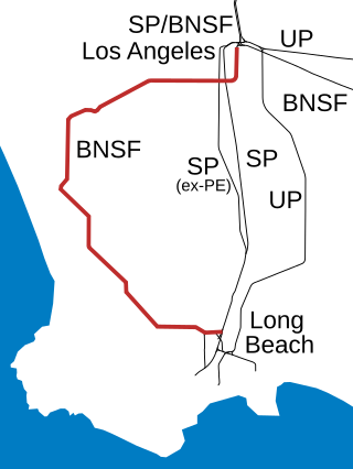
The Harbor Subdivision is a single-track main line of the BNSF Railway which stretches 53 miles (85 km) between rail yards near downtown Los Angeles and the ports of Los Angeles and Long Beach across southwestern Los Angeles County. It was the primary link between two of the world's busiest harbors and the national rail network. Mostly displaced with the April 15, 2002 opening of the more direct Alameda Corridor, the Harbor Sub takes a far more circuitous route from origin to destination, owing to its growth in segments over the decades. The subdivision was built in this fashion beginning in the early 1880s to serve the ports and the various businesses that developed along it.

The C Line is a 19.3-mile (31.1 km) light rail line running between Redondo Beach and Norwalk within Los Angeles County, California. It is one of six lines forming the Los Angeles Metro Rail system and opened on August 12, 1995. Along the route, the line serves the cities of Downey, El Segundo, Hawthorne, Norwalk and Lynwood, the Los Angeles community of Westchester, and several unincorporated communities in the South Los Angeles region including Athens, Del Aire, and Willowbrook. A free shuttle bus to Los Angeles International Airport (LAX) is available at the line's Aviation/LAX station.

Aviation/LAX station is an elevated light rail station on the C Line of the Los Angeles Metro Rail system. It is located over Aviation Boulevard, after which the station is named, near its intersection with Imperial Highway and south of Century Freeway in Los Angeles, California. It opened as part of the Green Line on August 12, 1995. The station was initially named Aviation Blvd/I-105, but in 2003, it was simplified and renamed Aviation/LAX to highlight its proximity to Los Angeles International Airport.

Crenshaw station is a elevated light rail station on the C Line of the Los Angeles Metro Rail system. It is located in the median of Interstate 105, above Crenshaw Boulevard, after which the station is named. The station is in the city of Hawthorne, California and opened as part of the Green Line on August 12, 1995.
Slauson station is a busway station located in Los Angeles, California. It is situated between the 37th Street/USC and Manchester stations on the J Line, a bus rapid transit route which runs between El Monte, Downtown Los Angeles and San Pedro as part of the Metro Busway system. The station consists of two side platforms in the center of Interstate 110 above Slauson Avenue. The station serves the Vermont-Slauson, South Park and Florence neighborhoods of Los Angeles.

The K Line is a 5.9-mile (9.5 km) light rail line running north–south between the Jefferson Park and Westchester neighborhoods of Los Angeles, California, passing through various South Los Angeles neighborhoods and the city of Inglewood. It is one of six lines in the Los Angeles Metro Rail system operated by the Los Angeles County Metropolitan Transportation Authority (LACMTA). It opened on October 7, 2022, making it the system's newest line.

Expo/Crenshaw station is a light rail station in the Los Angeles Metro Rail system located in the Jefferson Park neighborhood of Los Angeles at the intersection of Crenshaw and Exposition Boulevards. During construction, it was known as the Crenshaw station. The station is the transfer point between the E Line, which stops at two street-level platforms alongside Exposition Boulevard, and the K Line, which has its northern terminus at a single island platform under Crenshaw Boulevard.

The Sepulveda Transit Corridor Project is a two-phased planned transit corridor project that aims to connect the Los Angeles Basin to the San Fernando Valley through Sepulveda Pass in Los Angeles, California, by supplementing the existing I-405 freeway through the pass. The corridor would partly parallel I-405, and proposed alternatives include heavy rail rapid transit or a monorail line connecting the G Line in the Valley to the D Line and E Line on the Westside, and the K Line near Los Angeles International Airport.

Martin Luther King Jr. station is an underground light rail station on the K Line of the Los Angeles Metro Rail system. It is located underneath Crenshaw Boulevard at its intersection with Martin Luther King Jr. Boulevard, after which the station is named, in the Los Angeles neighborhoods of Baldwin Hills and Leimert Park. The station’s main entrance is next to the iconic Baldwin Hills Crenshaw Plaza shopping mall.

Leimert Park station is an underground light rail station on the K Line of the Los Angeles Metro Rail system. It is located underneath Crenshaw Boulevard at its intersection with Vernon Avenue in the Leimert Park neighborhood of Los Angeles.
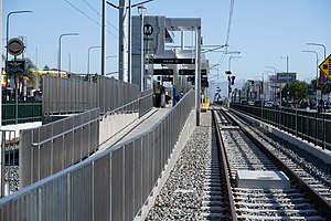
Fairview Heights station is an at-grade light rail station on the K Line of the Los Angeles Metro Rail system. It is located alongside Redondo Boulevard and near the intersection of Florence Avenue and West Boulevard in Inglewood but near the Hyde Park neighborhood of Los Angeles.

Downtown Inglewood station is an at-grade light rail station on the K Line of the Los Angeles Metro Rail system. It is located alongside Florence Avenue between Market and Locust Streets in the central business district of the city of Inglewood, California.

Westchester/Veterans station is an at-grade light rail station on the K Line of the Los Angeles Metro Rail system. It is located alongside Florence Avenue near its intersection of Hindry Avenue, located in the Westchester neighborhood of Los Angeles, but across the street from the city of Inglewood. The station serves as the temporary southern terminus of the K line until through-routing with the C Line commences.

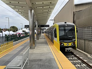
Aviation/Century station is an elevated light rail station on the C and K lines of the Los Angeles Metro Rail system. It is located alongside Aviation Boulevard above its intersection with Century Boulevard, located in the Westchester neighborhood of Los Angeles.

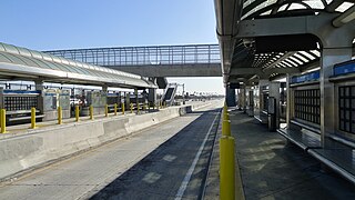
LAX/Metro Transit Center station is an under construction light rail transport hub in the Los Angeles Metro Rail system, located near Aviation Boulevard and 96th Street in the Westchester district of Los Angeles. The station was designed as a station for the C and K lines. It will serve as the transfer point between Metro Rail and the LAX Automated People Mover (APM) serving the Los Angeles International Airport terminals and facilities. Additionally, the station will have connections to Metro Bus, other municipal bus lines, a customer service center, and a Metro Bike Share hub. Metro is scheduled to start serving the station in late 2024 before the APM connection opens on December 8, 2025.

The K Line Northern Extension Project, formerly known as the Crenshaw Northern Extension Project, is a project planning a Los Angeles Metro Rail light rail transit corridor extension connecting Expo/Crenshaw station to Hollywood/Highland station in Hollywood. The corridor is a fully underground, north-south route along mostly densely populated areas on the western side of the Los Angeles Basin; it would be operated as part of the K Line. The Los Angeles County Metropolitan Transportation Authority (Metro) is prioritizing the project along with pressure from the West Hollywood residents. Construction is slated to start in 2041 and begin service by 2047 unless means to accelerate the project are found.
The history of the Los Angeles Metro Rail and Busway system begins in the early 1970s, when the traffic-choked region began planning a rapid transit system. The first dedicated busway opened along I-10 in 1973, and the region's first light rail line, the Blue Line opened in 1990. Today the system includes over 160 miles (260 km) of heavy rail, light rail, and bus rapid transit lines, with multiple new lines under construction as of 2019.

The Rail to Rail Active Transportation Corridor Project is a construction project building a rail trail in Los Angeles County, California, United States. It is being constructed by the Los Angeles County Metropolitan Transportation Authority (Metro).