
7th Street/Metro Center station is an underground light rail and rapid transit station on the A, B, D, and E lines of the Los Angeles Metro Rail system. The station also has street level stops for the J Line of the Los Angeles Metro Busway system. The station is located under 7th Street, after which the station is named, at its intersections with Figueroa, Flower and Hope Streets.
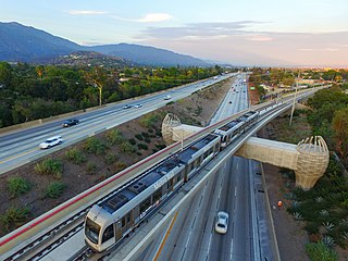
The A Line is a 48.5-mile (78.1 km) light rail line in Los Angeles County, California. It is one of the six lines of the Los Angeles Metro Rail system, operated by the Los Angeles County Metropolitan Transportation Authority (Metro). The A Line serves 44 stations and runs east-west between Azusa and Pasadena, then north-south between Pasadena and Long Beach. It interlines and shares five stations with the E Line in Downtown Los Angeles. Service operates for approximately 19 hours with headways of up to 8 minutes during peak hours. The A Line is currently the longest light rail line in the world.

Pico station is an at-grade light rail station on the Los Angeles Metro Rail system located on Flower Street at the intersection of Pico Boulevard. The station also has southbound bus stops on Flower Street, across from the station and northbound bus stops on Figueroa Street, one block to the west. Pico station serves the South Park and Figueroa/Convention District neighborhoods.

Grand/LATTC station is an at-grade light rail station on the A Line of the Los Angeles Metro Rail system. The station is located in the median of Washington Boulevard at its intersection with Grand Avenue, after which the station is named, along with Los Angeles Trade–Technical College (LATTC). One of the station's exits leads directly to the LATTC campus. The station also has nearby stops for the J Line of the Los Angeles Metro Busway system, southbound buses stop at the intersection of Flower Street and Washington Boulevard, one block to the west of the station, and northbound buses stop at the intersection of Figueroa Street and Washington Boulevard, two blocks to the west. In addition to the LATTC campus, the station also serves the South Los Angeles neighborhood.

Willow Street station is an at-grade light rail station on the A Line of the Los Angeles Metro Rail system. The station is located adjacent to Long Beach Boulevard its intersection with Willow Street, after which the station is named, in the Wrigley neighborhood of Long Beach, California.

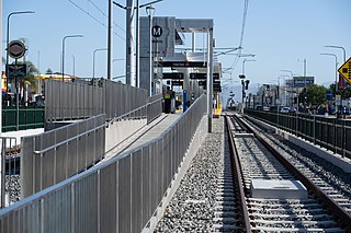
Wardlow station is an at-grade light rail station on the A Line of the Los Angeles Metro Rail system. The station is located on the A Line's exclusive right-of-way that parallels Pacific Place, at its intersection with Wardlow Street, after which the station is named, in the Wrigley neighborhood of Long Beach, California.
Vernon station is an at-grade light rail station on the A Line of the Los Angeles Metro Rail system. The station is located in the center median of Long Beach Avenue at its intersection with Vernon Avenue, in South Los Angeles, one-quarter mile (0.4 km) from the border with Vernon, California.
Slauson station is a busway station located in Los Angeles, California. It is situated between the 37th Street/USC and Manchester stations on the J Line, a bus rapid transit route which runs between El Monte, Downtown Los Angeles and San Pedro as part of the Metro Busway system. The station consists of two side platforms in the center of Interstate 110 above Slauson Avenue. The station serves the Vermont-Slauson, South Park and Florence neighborhoods of Los Angeles.

Mariachi Plaza station is an underground light rail station on the E Line of the Los Angeles Metro Rail system. It is located under 1st Street at the intersection of Boyle Avenue, with the main exit located at Mariachi Plaza, after which the station is named. The plaza is the historic gateway to the Boyle Heights neighborhood of Los Angeles. This station opened in 2009 as part of the Gold Line Eastside Extension and was one of two underground stations on the Eastside Extension.

Little Tokyo/Arts District station is an underground light rail station on the Los Angeles Metro Rail system. It replaced an at-grade station with the same name that was located on the east side of Alameda Street between 1st Street and Temple Street, on the edge of Little Tokyo and the Arts District in Downtown Los Angeles. The at-grade station opened in 2009 as part of the Gold Line Eastside Extension and was served by the L Line. The at-grade station closed in October 2020, and the new underground station on the south side of 1st Street between Central Avenue and Alameda Street opened on June 16, 2023.

Atlantic station is an at grade light rail station on the E Line of the Los Angeles Metro Rail system. It is located at the intersection of Atlantic and Pomona Boulevards in East Los Angeles.

The Whittier Line was a Pacific Electric interurban line which traveled between Los Angeles and Whittier via Huntington Park, Rivera, and Los Nietos. A branch of the company's original Long Beach Line, operations along the line began in 1903. Due to its indirect route, passenger operations were eventually replaced by bus service on Whittier Boulevard after 1938. Tracks were largely retained for use by freight trains, eventually becoming the Union Pacific La Habra Subdivision. A short segment of the route is expected to be reactivated for passenger service as part of the Southeast Gateway Line.

Expo/La Brea station is an elevated light rail station on the E Line of the Los Angeles Metro Rail system. The station is located over the intersection of Exposition Boulevard and La Brea Avenue, after which the station is named, in the West Adams neighborhood of Los Angeles.
Culver City station is an elevated light rail station on the E Line of the Los Angeles Metro Rail system. The station is located on a dedicated right-of-way alongside Exposition Boulevard — between the intersection of Venice Boulevard and Robertson Boulevard on the west and the intersection of Washington Boulevard and National Boulevard on the east. The station is located in the city of Culver City, California, after which the station is named.

La Habra–Fullerton–Yorba Linda Line was a Pacific Electric interurban line which traveled between Los Angeles and Yorba Linda.

The Fullerton Line was an interurban route of the Pacific Electric Railway. It ran between Downtown Los Angeles and Fullerton, California. It opened in 1917 and hosted passenger service until 1938; the line was retained for freight for some time thereafter. After abandonment, the right of way between La Habra and Fullerton was mostly converted to a rail trail or built over.

Martin Luther King Jr. station is an underground light rail station on the K Line of the Los Angeles Metro Rail system. It is located underneath Crenshaw Boulevard at its intersection with Martin Luther King Jr. Boulevard, after which the station is named, in the Los Angeles neighborhoods of Baldwin Hills and Leimert Park. The station’s main entrance is next to the iconic Baldwin Hills Crenshaw Plaza shopping mall.
Hyde Park station is an at-grade light rail station on the K Line of the Los Angeles Metro Rail system. It is located in the median of Crenshaw Boulevard between its intersections with Slauson Avenue and 59th Street in the Hyde Park neighborhood of Los Angeles.
The Southeast Gateway Line, formerly the West Santa Ana Branch Transit Corridor, is a planned light rail line, mostly following the Pacific Electric's historic West Santa Ana Branch, connecting Downtown Los Angeles to the city of Artesia, along with other cities in southeastern Los Angeles County.

The Rail to Rail Active Transportation Corridor Project is a construction project building a rail trail in Los Angeles County, California, United States. It is being constructed by the Los Angeles County Metropolitan Transportation Authority (Metro).


