
The Los Angeles County Metropolitan Transportation Authority (LACMTA), branded as Metro, is the county agency that plans, operates, and coordinates funding for most of the public transportation system in Los Angeles County, California, the most populated county in the United States, and the largest public transit agency in the county as well.

The C Line is a 19.3-mile (31.1 km) light rail line running between Redondo Beach and Norwalk within Los Angeles County, California. It is one of six lines forming the Los Angeles Metro Rail system and opened on August 12, 1995. Along the route, the line serves the cities of Downey, El Segundo, Hawthorne, Norwalk and Lynwood, the Los Angeles community of Westchester, and several unincorporated communities in the South Los Angeles region including Athens, Del Aire, and Willowbrook. A free shuttle bus to Los Angeles International Airport (LAX) is available at the line's Aviation/LAX station.

Aviation/LAX station is an elevated light rail station on the C Line of the Los Angeles Metro Rail system. It is located over Aviation Boulevard, after which the station is named, near its intersection with Imperial Highway and south of Century Freeway in Los Angeles, California. It opened as part of the Green Line on August 12, 1995. The station was initially named Aviation Blvd/I-105, but in 2003, it was simplified and renamed Aviation/LAX to highlight its proximity to Los Angeles International Airport.

Willowbrook/Rosa Parks station is a major transport hub and Los Angeles Metro Rail station that serves the A Line and C Line. The station, located at the intersection of Imperial Highway and Wilmington Avenue in the Willowbrook community of Los Angeles County, is a major transfer point for commuters.

The Toyota Sports Performance Center is a practice facility for the Los Angeles Kings, and the Ontario Reign, located on 555 North Nash Street in El Segundo, California. The $24 million, 135,000 square feet (12,500 m2) facility broke ground on April 28, 1999, and officially opened on March 5, 2000.
Avalon station is a elevated light rail station on the C Line of the Los Angeles Metro Rail system. It is located in the median of Interstate 105, above Avalon Boulevard, after which the station is named, in the unincorporated neighborhood of Green Meadows. It opened as part of the Green Line on August 12, 1995.

Lakewood Boulevard station is a below-grade light rail station on the C Line of the Los Angeles Metro Rail system. It is situated in the median of Interstate 105, below Lakewood Boulevard, after which the station is named. The station serves the city of Downey, California and opened as part of the Green Line on August 12, 1995.

Vermont/Athens station is a below-grade light rail station on the C Line of the Los Angeles Metro Rail system. It is situated in the median of Interstate 105 and named after Vermont Avenue and the Athens community where it is located. It opened as part of the Green Line on August 12, 1995.

El Segundo station is an elevated light rail station on the C Line of the Los Angeles Metro Rail system. It is located over El Segundo Boulevard, after which the station is named, near its intersection with Nash Street in El Segundo, California. It opened with the commencement of Green Line service on August 12, 1995.

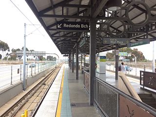
Redondo Beach station is an elevated light rail station on the C Line of the Los Angeles Metro Rail system. It is located over Marine Avenue in the city of Redondo Beach, California, after which the station is named. It opened with the commencement of Green Line service on August 12, 1995. The station is currently the western terminus of the C Line. An extension beyond Redondo Beach into Torrance is in the planning stages.

Douglas station is an elevated light rail station on the C Line of the Los Angeles Metro Rail system. It is located over Douglas Street, after which it is named, near Park Place and one block north of Rosecrans Avenue in El Segundo, California. It opened with the commencement of Green Line service on August 12, 1995.
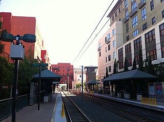
Del Mar station is an at-grade light rail station on the A Line of the Los Angeles Metro Rail system. It is located between Arroyo Parkway and Raymond Avenue at Del Mar Boulevard, after which the station is named, in Pasadena, California. The station is located on the site of the historic Pasadena Santa Fe Depot and the station building, built in 1935, still stands on the property.

Lake station is a below-grade light rail station on the A Line of the Los Angeles Metro Rail system. It is located in the median of Interstate 210, below North Lake Avenue, after which the station is named, in Pasadena, California. The light rail station opened on July 26, 2003, as part of the original Gold Line, then known as the "Pasadena Metro Blue Line" project.

The K Line is a 5.9-mile (9.5 km) light rail line running north–south between the Jefferson Park and Westchester neighborhoods of Los Angeles, California, passing through various South Los Angeles neighborhoods and the city of Inglewood. It is one of six lines in the Los Angeles Metro Rail system operated by the Los Angeles County Metropolitan Transportation Authority (LACMTA). It opened on October 7, 2022, making it the system's newest line.

El Monte station is a train station on Metrolink's San Bernardino Line in El Monte, California. It is at 10925 Railroad Street between Santa Anita and Tyler Avenues north of Valley Boulevard. It has 238 parking spaces. The station is owned by the City of El Monte.

Duarte/City of Hope station is an at-grade light rail station on the A Line of the Los Angeles Metro Rail system. It is located at the intersection of Duarte Road and Highland Avenue in Duarte, California, after which the station is named, along with the City of Hope National Medical Center located across the street from the station.

Metro Busway is a system of bus rapid transit (BRT) routes that operate primarily along exclusive or semi-exclusive roadways known locally as a busway or transitway. There are currently two lines serving 29 stations in the system: the G Line in the San Fernando Valley, and the J Line, serving El Monte, Downtown Los Angeles, Gardena, and San Pedro. The Los Angeles County Metropolitan Transportation Authority (Metro) operates the Metro Busway system.

The Sepulveda Transit Corridor Project is a two-phased planned transit corridor project that aims to connect the Los Angeles Basin to the San Fernando Valley through Sepulveda Pass in Los Angeles, California, by supplementing the existing I-405 freeway through the pass. The corridor would partly parallel I-405, and proposed alternatives include heavy rail rapid transit or a monorail line connecting the G Line in the Valley to the D Line and E Line on the Westside, and the K Line near Los Angeles International Airport.

Grand Avenue Arts/Bunker Hill station is an underground light rail station on the A and E lines of the Los Angeles Metro Rail system. The station also has street level stops for the J Line of the Los Angeles Metro Busway system. The station is located under the intersection of 2nd Place and Hope Street, near the Grand Avenue Arts district and in the Bunker Hill neighborhood of Downtown Los Angeles, after which the station is named. In planning documents, the station was originally referred to as 2nd Place/Hope.

