List of census-designated places in Wisconsin

Last updated

Map of the United States with Wisconsin highlighted Wisconsin in United States.svg
Map of the United States with Wisconsin highlighted

This article lists census-designated places (CDPs) in the U.S. state of Wisconsin . As of 2018, there were a total of 176 census-designated places in Wisconsin, down from 179 in the 2010 Census. Lake Shangrila and Pell Lake were annexed by Bristol and Bloomfield in 2011, respectively. Windsor incorporated in 2015.

Contents

Census-Designated Places

CDP [1] PopulationCounty
Abrams 358 Oconto
Allens Grove 174 Walworth
Allenton 823 Washington
Alto 166 Fond du Lac
Amberg 147 Marinette
Angelica 94 Shawano
Argonne 135 Forest
Arkansaw 194 Pepin
Arkdale 201 Adams
Ashippun 1,166 Dodge
Babcock 122 Wood
Baileys Harbor 334 Door
Bancroft 526 Portage
Barronett 103 Barron
Batavia 242 Sheboygan
Bayfront 113 Ashland
Big Foot Prairie 22 Walworth
Birch Hill 295 Ashland
Bluffview 536 Sauk
Bohners Lake 2,374 Racine
Boulder Junction 179 Vilas
Brice Prairie 1,961 La Crosse
Briggsville 316 Marquette
Brothertown 201 Calumet
Browns Lake 1,879 Racine
Brule 208 Douglas
Burnett 220 Dodge
Butte des Morts 1,005 Winnebago
Cable 177 Bayfield
Caroline 236 Shawano
Cataract 220 Monroe
Ceex Haci 89 Wood
Chain O' Lakes 1,124 Waupaca
Chelsea 106 Taylor
Chief Lake 582 Sawyer
Chili 205 Clark
Clam Lake 36 Ashland
Clarks Mills 149 Manitowoc
Collins 203 Manitowoc
Como 2,356 Walworth
Cornucopia 103 Bayfield
Dale 570 Outagamie
Dalton 215 Green Lake
Danbury 165 Burnett
Dekorra 255 Columbia
Delavan Lake 2,803 Walworth
Dellwood 579 Adams
Diamond Bluff 184 Pierce
Diaperville 67 Ashland
Dodge 121 Trempealeau
Downsville 188 Dunn
Drummond 169 Bayfield
Dunbar 61 Marinette
Dyckesville 490 Brown and Kewaunee
Eagle Lake 1,251 Racine
Easton 86 Adams
Edmund 129 Iowa
Elcho 327 Langlade
Ellison Bay 249 Door
Emerald 145 St. Croix
Eureka 247 Winnebago
Florence 641 Florence
Forest Junction 746 Calumet
Franks Field 160 Ashland
French Island 4,284 La Crosse
Fulton 117 Rock
Gibbsville 486 Sheboygan
Gilmanton 155 Buffalo
Glen Haven 64 Grant
Glidden 437 Ashland
Goodman 241 Marinette
Gordon 145 Douglas
Gotham 189 Richland
Grand Marsh 110 Adams
Grand View 117 Bayfield
Greenbush 159 Sheboygan
Greenleaf 733 Brown
Green Valley 110 Shawano
Hager City 357 Pierce
Hanover 179 Rock
Harrisville 90 Marquette
Hatfield 176 Jackson
Hebron 209 Jefferson
Helenville 238 Jefferson
Herbster 130 Bayfield
Hingham 899 Sheboygan
Holcombe 239 Chippewa
Houlton 377 St. Croix
Humbird 254 Clark
Iron Belt 158 Iron
Iron River 768 Bayfield
Ixonia 2,367 Jefferson
Jim Falls 231 Chippewa
Jolmaville 126 Ashland
Juda 340 Green
Jump River 53 Taylor
Keshena 1,257 Menominee
Kieler 557 Grant
King 1,242 Waupaca
Knowlton 94 Marathon
Krakow 378 Shawano
Lac du Flambeau 1,845 Vilas
Lake Arrowhead 946 Adams
Lake Camelot 895 Adams
Lake Ivanhoe 461 Walworth
Lake Koshkonong 1,239 Jefferson
Lake Lorraine 338 Walworth
Lake Ripley 1,911 Jefferson
Lake Sherwood 357 Adams
Lake Tomahawk 246 Oneida
Lake Wazeecha 3,107 Wood
Lake Wisconsin 4,616 Columbia and Sauk
Lake Wissota 2,830 Chippewa
Lakewood 241 Oconto
Laona 519 Forest
Lauderdale Lakes 1,283 Walworth
Lebanon 187 Dodge
Legend Lake 1,670 Menominee
Leopolis 86 Shawano
Lewis 87 Polk
Lily Lake 508 Kenosha
Little Round Lake 1,242 Sawyer
Little Sturgeon 177 Door
Long Lake 59 Florence
Lyons 932 Walworth
Marengo 148 Ashland
Mercer 551 Iron
Middle Village 290 Menominee and Shawano
Millston 113 Jackson
Mindoro 291 La Crosse
Minocqua 411 Oneida
Mission 297 Jackson
Mole Lake 535 Forest
Mountain 289 Oconto
Navarino 177 Shawano
Neopit 616 Menominee
New Munster 286 Kenosha
New Odanah 466 Ashland
New Post 302 Sawyer
Newald 70 Forest
North Lake 247 Waukesha
Northport 459 Waupaca
Odanah 47 Ashland
Ogema 188 Price
Okauchee Lake 5,094 Waukesha
Paac Ciinak 83 Shawano
Packwaukee 242 Marquette
Pella 207 Shawano
Pembine 188 Marinette
Pence 123 Iron
Pine River 144 Waushara
Polonia 565 Portage
Port Wing 156 Bayfield
Post Lake 343 Langlade
Potter Lake 1,117 Walworth
Powers Lake 1,401 Kenosha
Poy Sippi 379 Waushara
Pulcifer 131 Shawano
Reserve 349 Sawyer
Rib Mountain 6,061 Marathon
Rock Creek 160 Dunn
Rome 752 Jefferson
Rubicon 235 Dodge
St. Joseph 387 La Crosse
St. Peter 1,642 Fond du Lac
Sand Pillow 262 Jackson
Sandy Hook 293 Grant
Saxon 75 Iron
Sayner 231 Vilas
Sextonville 476 Richland
Seymour 1,501 Eau Claire
Shopiere 154 Rock
Sobieski 2,575 Oconto
Springbrook 89 Washburn
Springfield 168 Walworth
Stone Lake 186 Sawyer and Washburn
Summit Lake 141 Langlade
Tainter Lake 2,550 Dunn
Taycheedah 643 Fond du Lac
Thornton 63 Shawano
Three Lakes 605 Oneida
Tichigan 5,277 Racine
Tilleda 71 Shawano
Townsend 179 Oconto
Trego 187 Washburn
Tunnel City 100 Monroe
Turtle Lake 348 Walworth
Tustin 120 Waushara
Van Dyne 292 Fond du Lac
Wabeno 575 Forest
Waubeka 640 Ozaukee
Waukau 302 Winnebago
Waumandee 62 Buffalo
Westboro 213 Taylor
Whittlesey 97 Taylor
Winchester 649 Winnebago
Wind Lake 5,355 Racine
Wiota 71 Lafayette
Woodford 71 Lafayette
Woodruff 891 Oneida
Zoar 107 Menominee

Related Research Articles

<span class="mw-page-title-main">Sheboygan County, Wisconsin</span> County in Wisconsin, United States

Sheboygan County is a county in the U.S. state of Wisconsin. It is named after the Sheboygan River. As of the 2020 census, the population was 118,034. Its county seat is Sheboygan. The county was created in 1836 and organized in 1846. At the time, it was located in the Wisconsin Territory. Sheboygan County comprises the Sheboygan, WI Metropolitan Statistical Area. Part of the Holyland region is located in northwestern Sheboygan County.

<span class="mw-page-title-main">Green Lake County, Wisconsin</span> County in Wisconsin, United States

Green Lake County is a county located in the U.S. state of Wisconsin. As of the 2020 census, the population was 19,018. Its county seat is Green Lake. In 2020, the center of population of Wisconsin was located in Green Lake County, near the city of Markesan.

Gages Lake is a census-designated place (CDP) in Warren Township, Lake County, Illinois, United States. The population was 10,637 at the 2020 census.

<span class="mw-page-title-main">Rome, Adams County, Wisconsin</span> Town in Wisconsin, United States

The Town of Rome is located in Adams County in the U.S. state of Wisconsin. The population was 2,720 at the 2010 census. The census-designated places of Lake Arrowhead, Lake Camelot, and Lake Sherwood are located in the town. The unincorporated communities of New Rome and Rome are also located in the town.

<span class="mw-page-title-main">Lake Ripley, Wisconsin</span> Census-designated place in Wisconsin, United States

Lake Ripley is a census-designated place (CDP), in the town of Oakland, Jefferson County, Wisconsin, United States. The population was 1,911 at the 2020 census.

<span class="mw-page-title-main">Lake Wisconsin, Wisconsin</span> CDP in Wisconsin, United States

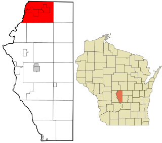
Lake Wisconsin is a census-designated place (CDP) in Columbia and Sauk counties, in the towns of Lodi and Merrimac, in Wisconsin, United States. The population was 4,189 at the 2010 census.

Livonia is a town in Livingston County, New York, United States. As of the 2010 census, the town population was 7,809. The town contains a village also named Livonia. The town is on the eastern border of the county.

A census-designated place (CDP) is a concentration of population defined by the United States Census Bureau for statistical purposes only.

<span class="mw-page-title-main">Watersmeet, Michigan</span> Census-designated place & unincorporated community in Michigan, United States

Watersmeet is an unincorporated community and census-designated place (CDP) in Watersmeet Township, Michigan. As of the 2010 census, the CDP had a population of 428, out of a total population in the township of 1,417. The community was platted in 1884, designated as a station of the Milwaukee Lake Shore and Western Railroad.

Sayner is a census-designated place in the Town of Plum Lake in Vilas County, Wisconsin, United States. It is located at the intersection of Highway 155 and County N, about 15 miles northwest of Eagle River. As of the 2010 census, its population was 207. Sayner has an area of 1.828 square miles (4.73 km2); 1.826 square miles (4.73 km2) of this is land, and 0.002 square miles (0.0052 km2) is water. Sayner got its name from Orrin W. Sayner, who settled the area in 1891, two years before any other settlers took up homes in the town. In 1895, the Milwaukee Road extended its Valley Line north from Woodruff to Star Lake, with a stop in Sayner. The line primarily carried lumber from area forests, later carried tourists and had been abandoned in the middle 20th century.

<span class="mw-page-title-main">Butte des Morts, Wisconsin</span> Census-designated place in Wisconsin, United States

Butte des Morts is an unincorporated census-designated place in the town of Winneconne, in Winnebago County, Wisconsin, United States.

<span class="mw-page-title-main">Mole Lake, Wisconsin</span> Census-designated place in Wisconsin, United States

Mole Lake, Wisconsin is a census-designated place located in the town of Nashville in Forest County, Wisconsin, United States.

<span class="mw-page-title-main">Summit Lake, Wisconsin</span> Census-designated place in Wisconsin, United States

Summit Lake is an unincorporated community and census-designated place (CDP) in Langlade County, Wisconsin, United States. Summit Lake is located along U.S. Route 45 17 miles (27 km) north of Antigo, in the towns of Upham and Elcho. Summit Lake has a post office with ZIP code 54485. As of the 2010 census its population was 144.

Stone Lake is an unincorporated census-designated place in Sawyer and Washburn counties, Wisconsin, United States. Stone Lake is located on the eastern shore of Stone Lake and along Wisconsin Highway 70, 12 miles (19 km) west-northwest of Couderay. The Sawyer County portion of the community is located in the town of Sand Lake, while the Washburn County portion is located in the town of Stone Lake. As of the 2010 census, its population is 178.

<span class="mw-page-title-main">Long Lake (CDP), Wisconsin</span> Census-designated place in Wisconsin, United States

Long Lake is an unincorporated census-designated place in the town of Long Lake, Florence County, Wisconsin, United States. Long Lake is located on the eastern shore of Long Lake along Wisconsin Highway 139, 21 miles (34 km) west-southwest of Florence. As of the 2020 census, its population was 59. The community became a census-designated place in 2010. The community has the 54542 ZIP code.

<span class="mw-page-title-main">Three Lakes (CDP), Wisconsin</span> Census-designated place in Wisconsin, United States

Three Lakes is an unincorporated census-designated place located in the town of Three Lakes, Oneida County, Wisconsin, United States. Three Lakes is located at the junction of U.S. Route 45 and Wisconsin Highway 32 9 miles (14 km) south-southeast of Eagle River. Three Lakes has a post office with ZIP code 54562. As of the 2010 census, its population is 605.

Post Lake is an unincorporated community and census-designated place (CDP) in the town of Elcho, Langlade County, Wisconsin, United States. Post Lake is 12 miles (19 km) southwest of Crandon. As of the 2010 census, its population was 374.

Chain O' Lakes is a census-designated place in the towns of Farmington and Dayton, Waupaca County, Wisconsin, United States. Its population was 981 as of the 2010 census. Before 2010, it was part of the Chain O' Lakes-King CDP. It consists of twenty-two lakes connected by channels, natural openings, and creeks. In the Menominee language, the chain of lakes are called Sīsepikamiw. This name literally means "Sprawling water, like an animal basking in the sun".

Big Foot Prairie is an unincorporated community and census-designated place in McHenry County, Illinois, United States. It was named a CDP for the 2020 census, at which time it had a population of 65. It is located in Chemung Township. Big Foot Prairie is located on U.S. Route 14, 5 miles (8.0 km) north of Harvard. The community extends north into Walworth County, Wisconsin, where there is a CDP of the same name in the town of Walworth.

References

  1. "Wisconsin: 2010 - Census Bureau" (PDF). United States Census Bureau.

See also