National Register of Historic Places listings in Isanti County, Minnesota

Last updated

Location of Isanti County in Minnesota Map of Minnesota highlighting Isanti County.svg
Location of Isanti County in Minnesota

This is a list of the National Register of Historic Places listings in Isanti County, Minnesota. It is intended to be a complete list of the properties and districts on the National Register of Historic Places in Isanti County, Minnesota, United States. The locations of National Register properties and districts for which the latitude and longitude coordinates are included below, may be seen in an online map.

Contents

There are 8 properties and districts listed on the National Register in the county. A supplementary list includes one additional site that was formerly on the National Register.


    This National Park Service list is complete through NPS recent listings posted January 12, 2024. [1]

Current listings

Map all coordinates using: OpenStreetMap
[2] Name on the RegisterImageDate listed [3] Location City or townDescription
1 District No. 1 School
District No. 1 School Spencer Brook School.jpg
District No. 1 School
July 24, 1980
(#80002078)
Off County Highway 7
45°31′18″N93°26′38″W / 45.521667°N 93.443889°W / 45.521667; -93.443889 (District No. 1 School)
Spencer Brook 1874 one-room schoolhouse, a rare surviving structure from one of the county's earliest settlements, founded in the late 1850s by native-born New Englanders. [4]
2 Edward Erickson Farmstead
Edward Erickson Farmstead Edward Erickson Farm 1.JPG
Edward Erickson Farmstead
July 24, 1980
(#80002071)
County Highway 56 and Minnesota Highway 65
45°26′32″N93°14′18″W / 45.442222°N 93.238333°W / 45.442222; -93.238333 (Edward Erickson Farmstead)
Isanti vicinityWell-preserved potato farm with second-generation buildings mostly constructed 1915–1930; the legacy of a prosperous local farmer and an important cash crop in early-20th-century Isanti County. [5]
3 Isanti County Courthouse
Isanti County Courthouse Isanti Co Courthouse 4.JPG
Isanti County Courthouse
July 24, 1980
(#80002074)
237 2nd Ave., SW.
45°34′17″N93°13′35″W / 45.571297°N 93.226306°W / 45.571297; -93.226306 (Isanti County Courthouse)
Cambridge 1887 courthouse, nominated for being one of Minnesota's oldest courthouses still in use and the long-serving home of the county government. [6] Now a commercial office building.
4 Linden Barn
Linden Barn Linden Barn 2.JPG
Linden Barn
July 24, 1980
(#80002075)
County Highway 19
45°31′16″N93°10′36″W / 45.521105°N 93.176634°W / 45.521105; -93.176634 (Linden Barn)
Isanti Township Prominent 1914 round barn and adjacent silo, emblematic of the Swedish immigrants and agricultural developments that characterize much of Isanti County's history. [7]
5 Oscar Olson House
Oscar Olson House Oscar Olson House.JPG
Oscar Olson House
July 24, 1980
(#80002073)
309 Beechwood
45°43′36″N93°10′05″W / 45.726725°N 93.16811°W / 45.726725; -93.16811 (Oscar Olson House)
Braham Large Colonial Revival house built in 1914, noted for its long occupancy by a local banker and civic leader (d. 1973) and its distinctiveness among Isanti County's housing stock. [8]
6 St. John's Lutheran Church
St. John's Lutheran Church St. John's Lutheran Church.jpg
St. John's Lutheran Church
July 24, 1980
(#80002072)
County Highway 5
45°30′01″N93°17′20″W / 45.500186°N 93.288992°W / 45.500186; -93.288992 (St. John's Lutheran Church)
Isanti vicinityWell-preserved example of Isanti County's small, rural churches—built in 1882—and a symbol of its early German immigrants. [9]
7 Svenska Mission Kyrka I Sodre Maple Ridge
Svenska Mission Kyrka I Sodre Maple Ridge Swedish Mission Church of South Maple Ridge.jpg
Svenska Mission Kyrka I Sodre Maple Ridge
July 24, 1980
(#80002077)
County Highway 1
45°39′58″N93°19′40″W / 45.666146°N 93.327913°W / 45.666146; -93.327913 (Svenska Mission Kyrka I Sodre Maple Ridge)
Maple Ridge Township 1897 Swedish Mission church, a well-preserved example of the small, non-Lutheran churches established by Isanti County's Reformed Swedish settlers. [10]
8 West Riverside School
West Riverside School West Riverside School.jpg
West Riverside School
July 24, 1980
(#80002076)
County Highway 14
45°35′00″N93°14′44″W / 45.583468°N 93.245565°W / 45.583468; -93.245565 (West Riverside School)
Cambridge vicinityBrick one-room schoolhouse built in 1898, a particularly fine example of the usual venues for education in rural Isanti County in the late 19th and early 20th centuries. [11]

Former listings

[2] Name on the RegisterImageDate listedDate removedLocationCity or townDescription
1 Farmers Cooperative Mercantile Company of West Stanford July 24, 1980
(#80002079)
May 23, 2016County Highway 7
45°26′40″N93°27′34″W / 45.444444°N 93.459444°W / 45.444444; -93.459444 (Farmers Cooperative Mercantile Company of West Stanford)
Crown 1924 cooperative store operated by local farmers. [12] Burned down in 2008. [13]

See also

Related Research Articles

<span class="mw-page-title-main">National Register of Historic Places listings in Scott County, Minnesota</span>

This is a list of the National Register of Historic Places listings in Scott County, Minnesota. It is intended to be a complete list of the properties and districts on the National Register of Historic Places in Scott County, Minnesota, United States. The locations of National Register properties and districts for which the latitude and longitude coordinates are included below, may be seen in an online map.

<span class="mw-page-title-main">National Register of Historic Places listings in Rice County, Minnesota</span>

This is a list of the National Register of Historic Places listings in Rice County, Minnesota. It is intended to be a complete list of the properties and districts on the National Register of Historic Places in Rice County, Minnesota, United States. The locations of National Register properties and districts for which the latitude and longitude coordinates are included below, may be seen in an online map.

<span class="mw-page-title-main">National Register of Historic Places listings in Carver County, Minnesota</span>

This is a list of the National Register of Historic Places listings in Carver County, Minnesota. It is intended to be a complete list of the properties and districts on the National Register of Historic Places in Carver County, Minnesota, United States. The locations of National Register properties and districts for which the latitude and longitude coordinates are included below, may be seen in an online map.

<span class="mw-page-title-main">National Register of Historic Places listings in Goodhue County, Minnesota</span>

This is a list of the National Register of Historic Places listings in Goodhue County, Minnesota. It is intended to be a complete list of the properties and districts on the National Register of Historic Places in Goodhue County, Minnesota, United States. The locations of National Register properties and districts for which the latitude and longitude coordinates are included below, may be seen in an online map.

<span class="mw-page-title-main">National Register of Historic Places listings in St. Louis County, Minnesota</span>

This is a list of the National Register of Historic Places listings in Saint Louis County, Minnesota. It is intended to be a complete list of the properties and districts on the National Register of Historic Places in Saint Louis County, Minnesota, United States. The locations of National Register properties and districts for which the latitude and longitude coordinates are included below, may be seen in an online map.

<span class="mw-page-title-main">National Register of Historic Places listings in Stearns County, Minnesota</span>

This is a list of the National Register of Historic Places listings in Stearns County, Minnesota. It is intended to be a complete list of the properties and districts on the National Register of Historic Places in Stearns County, Minnesota, United States. The locations of National Register properties and districts for which the latitude and longitude coordinates are included below, may be seen in an online map.

<span class="mw-page-title-main">National Register of Historic Places listings in Anoka County, Minnesota</span>

This is a list of the National Register of Historic Places listings in Anoka County, Minnesota. It is intended to be a complete list of the properties and districts on the National Register of Historic Places in Anoka County, Minnesota, United States. The locations of National Register properties and districts for which the latitude and longitude coordinates are included below, may be seen in an online map.

<span class="mw-page-title-main">National Register of Historic Places listings in Brown County, Minnesota</span>

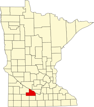
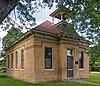
This is a list of the National Register of Historic Places listings in Brown County, Minnesota. It is intended to be a complete list of the properties and districts on the National Register of Historic Places in Brown County, Minnesota, United States. The locations of National Register properties and districts for which the latitude and longitude coordinates are included below, may be seen in an online map.

<span class="mw-page-title-main">National Register of Historic Places listings in Crow Wing County, Minnesota</span>

This is a list of the National Register of Historic Places listings in Crow Wing County, Minnesota. It is intended to be a complete list of the properties and districts on the National Register of Historic Places in Crow Wing County, Minnesota, United States. The locations of National Register properties and districts for which the latitude and longitude coordinates are included below, may be seen in an online map.

<span class="mw-page-title-main">National Register of Historic Places listings in Redwood County, Minnesota</span>

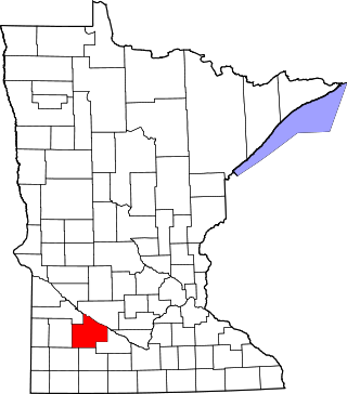
This is a list of the National Register of Historic Places listings in Redwood County, Minnesota. It is intended to be a complete list of the properties and districts on the National Register of Historic Places in Redwood County, Minnesota, United States. The locations of National Register properties and districts for which the latitude and longitude coordinates are included below, may be seen in an online map.

<span class="mw-page-title-main">National Register of Historic Places listings in Chisago County, Minnesota</span>

This is a list of the National Register of Historic Places listings in Chisago County, Minnesota. It is intended to be a complete list of the properties and districts on the National Register of Historic Places in Chisago County, Minnesota, United States. The locations of National Register properties and districts for which the latitude and longitude coordinates are included below, may be seen in an online map.

<span class="mw-page-title-main">National Register of Historic Places listings in Itasca County, Minnesota</span>

This is a list of the National Register of Historic Places listings in Itasca County, Minnesota. It is intended to be a complete list of the properties and districts on the National Register of Historic Places in Itasca County, Minnesota, United States. The locations of National Register properties and districts for which the latitude and longitude coordinates are included below, may be seen in an online map.

<span class="mw-page-title-main">National Register of Historic Places listings in Le Sueur County, Minnesota</span>

This is a list of the National Register of Historic Places listings in Le Sueur County, Minnesota. It is intended to be a complete list of the properties and districts on the National Register of Historic Places in Le Sueur County, Minnesota, United States. The locations of National Register properties and districts for which the latitude and longitude coordinates are included below, may be seen in an online map.

<span class="mw-page-title-main">National Register of Historic Places listings in Cook County, Minnesota</span>

This is a list of the National Register of Historic Places listings in Cook County, Minnesota. It is intended to be a complete list of the properties and districts on the National Register of Historic Places in Cook County, Minnesota, United States. The locations of National Register properties and districts for which the latitude and longitude coordinates are included below, may be seen in an online map.

<span class="mw-page-title-main">National Register of Historic Places listings in Houston County, Minnesota</span>

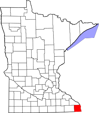
This is a list of the National Register of Historic Places listings in Houston County, Minnesota. It is intended to be a complete list of the properties and districts on the National Register of Historic Places in Houston County, Minnesota, United States. The locations of National Register properties and districts for which the latitude and longitude coordinates are included below, may be seen in an online map.

<span class="mw-page-title-main">National Register of Historic Places listings in Faribault County, Minnesota</span>

This is a list of the National Register of Historic Places listings in Faribault County, Minnesota. This is intended to be a complete list of the properties and districts on the National Register of Historic Places in Faribault County, Minnesota, United States. The locations of National Register properties and districts for which the latitude and longitude coordinates are included below, may be seen in an online map.

<span class="mw-page-title-main">National Register of Historic Places listings in Kandiyohi County, Minnesota</span>

This is a list of the National Register of Historic Places listings in Kandiyohi County, Minnesota. It is intended to be a complete list of the properties and districts on the National Register of Historic Places in Kandiyohi County, Minnesota, United States. The locations of National Register properties and districts for which the latitude and longitude coordinates are included below, may be seen in an online map.

<span class="mw-page-title-main">National Register of Historic Places listings in Swift County, Minnesota</span>

This is a list of the National Register of Historic Places listings in Swift County, Minnesota. It is intended to be a complete list of the properties and districts on the National Register of Historic Places in Swift County, Minnesota, United States. The locations of National Register properties and districts for which the latitude and longitude coordinates are included below, may be seen in an online map.

<span class="mw-page-title-main">National Register of Historic Places listings in Dodge County, Minnesota</span>

This is a list of the National Register of Historic Places listings in Dodge County, Minnesota. It is intended to be a complete list of the properties and districts on the National Register of Historic Places in Dodge County, Minnesota, United States. The locations of National Register properties and districts for which the latitude and longitude coordinates are included below, may be seen in an online map.

<span class="mw-page-title-main">National Register of Historic Places listings in Mower County, Minnesota</span>

This is a list of the National Register of Historic Places listings in Mower County, Minnesota. It is intended to be a complete list of the properties and districts on the National Register of Historic Places in Mower County, Minnesota, United States. The locations of National Register properties and districts for which the latitude and longitude coordinates are included below, may be seen in an online map.

References

  1. National Park Service, United States Department of the Interior, "National Register of Historic Places: Weekly List Actions", retrieved January 12, 2024.
  2. 1 2 Numbers represent an alphabetical ordering by significant words. Various colorings, defined here, differentiate National Historic Landmarks and historic districts from other NRHP buildings, structures, sites or objects.
  3. The eight-digit number below each date is the number assigned to each location in the National Register Information System database, which can be viewed by clicking the number.
  4. Bloomberg, Britta (December 1979). "Minnesota Historic Properties Inventory Form: Isanti School District #1". National Park Service. Retrieved 2016-10-09.{{cite journal}}: Cite journal requires |journal= (help)
  5. Bloomberg, Britta (December 1979). "Minnesota Historic Properties Inventory Form: Erickson Farmstead". National Park Service. Retrieved 2016-09-25.{{cite journal}}: Cite journal requires |journal= (help)
  6. Bloomberg, Britta (December 1979). "Minnesota Historic Properties Inventory Form: Isanti County Courthouse". National Park Service. Retrieved 2016-09-25.{{cite journal}}: Cite journal requires |journal= (help)
  7. Bloomberg, Britta (December 1979). "Minnesota Historic Properties Inventory Form: Linden Barn". National Park Service. Retrieved 2016-09-22.{{cite journal}}: Cite journal requires |journal= (help)
  8. Bloomberg, Britta (December 1979). "Minnesota Historic Properties Inventory Form: Oscar Olson House". National Park Service. Retrieved 2016-09-22.{{cite journal}}: Cite journal requires |journal= (help)
  9. Bloomberg, Britta (December 1979). "Minnesota Historic Properties Inventory Form: German Evangelical Lutheran Church St. Johns". National Park Service. Retrieved 2016-09-22.{{cite journal}}: Cite journal requires |journal= (help)
  10. Bloomberg, Britta (December 1980). "Minnesota Historic Properties Inventory Form: Svenska Mission Kyrka i Sodre Maple Ridge". National Park Service. Retrieved 2016-09-22.{{cite journal}}: Cite journal requires |journal= (help)
  11. Bloomberg, Britta (December 1979). "Minnesota Historic Properties Inventory Form: West Riverside School, District No. 38". National Park Service. Retrieved 2016-09-18.{{cite journal}}: Cite journal requires |journal= (help)
  12. Nord, Mary Ann (2003). The National Register of Historic Places in Minnesota . Minnesota Historical Society. ISBN   0-87351-448-3.
  13. Farmers Cooperative Mercantile Company of West Stanford file, State Historic Preservation Office in the Minnesota History Center.