List of bridges on the National Register of Historic Places in Minnesota

Last updated

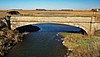
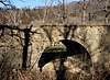
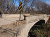
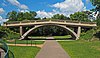
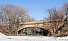
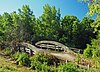
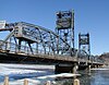
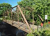
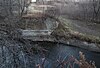
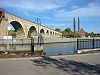
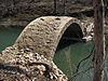
This is a list of bridges on the National Register of Historic Places in the U.S. state of Minnesota. [1]

NameImageBuiltListedLocationCountyType
Aerial Lift Bridge Aerial lift bridge duluth mn.jpg 1901, 1905, 19291973-05-22 Duluth
46°46′45″N92°5′34″W / 46.77917°N 92.09278°W / 46.77917; -92.09278 (Aerial Lift Bridge)
St. Louis Vertical lift
Anoka–Champlin Mississippi River Bridge Anoka-Champlin Bridge.jpg 19291979-12-31 Anoka, Champlin
45°11′25″N93°23′45″W / 45.19028°N 93.39583°W / 45.19028; -93.39583 (Anoka-Champlin Mississippi River Bridge)
Anoka, Hennepin Concrete arch
Bridge No. 12 BridgeNo12.jpg 19081989-11-06 Red Wing
44°32′31″N92°26′19″W / 44.54194°N 92.43861°W / 44.54194; -92.43861 (Bridge No. 12)
Goodhue Warren pony truss
Bridge No. 1482 Bridge No. 1482.jpg 19081992-06-25 Luverne
43°37′45″N96°12′36″W / 43.62917°N 96.21000°W / 43.62917; -96.21000 (Bridge No. 1482)
Rock Pony truss
Bridge No. 3355-Kathio Township Bridge 3355.jpg 19391998-06-29 Kathio Township
46°12′56″N93°47′33″W / 46.21556°N 93.79250°W / 46.21556; -93.79250 (Bridge No. 3355-Kathio Township)
Mille Lacs Concrete slab
Bridge No. 3589-Silver Creek Township Stewart Bridge 001.JPG 1924, 19391998-06-29 Silver Creek Township
47°2′59″N91°37′50″W / 47.04972°N 91.63056°W / 47.04972; -91.63056 (Bridge No. 3589-Silver Creek Township)
Lake Concrete arch
Bridge No. 4846 Bridge4846ShanaskaCreekMN.jpg 1875, 19291981-02-17 Kasota
44°15′59″N93°53′54″W / 44.26639°N 93.89833°W / 44.26639; -93.89833 (Bridge No. 4846)
Le Sueur Pratt through truss
Bridge No. 4969 Camp Ripley Bridge.jpg 19302015-01-21 Camp Ripley
44°4′28″N94°20′6″W / 44.07444°N 94.33500°W / 44.07444; -94.33500 (Bridge No. 4969)
Morrison Steel plate girder
Bridge No. 5083-Marshall Bridge No. 5083.jpg 19311998-06-29 Marshall
44°26′58″N95°47′6″W / 44.44944°N 95.78500°W / 44.44944; -95.78500 (Bridge No. 5083-Marshall)
Lyon Concrete girder
Bridge No. 5151-Marshall BridgeNo5151Marshall.jpg 19311998-06-29 Marshall
44°26′35″N95°47′58″W / 44.44306°N 95.79944°W / 44.44306; -95.79944 (Bridge No. 5151-Marshall)
Lyon Concrete girder
Bridge No. 5265-Garrison Bridge 5265.jpg 19381998-06-29 Garrison
46°17′19″N93°49′29″W / 46.28861°N 93.82472°W / 46.28861; -93.82472 (Bridge No. 5265-Garrison)
Crow Wing Multi-plate arch
Bridge No. 5388 Bridge5388.jpg 19351998-06-26 Le Roy Township
43°31′56″N92°31′7″W / 43.53222°N 92.51861°W / 43.53222; -92.51861 (Bridge No. 5388)
Mower Warren polygonal pony truss
Bridge No. 5721 Bridge No. 5721.jpg 1877, 19371998-07-13 Stillwater Township
45°6′16″N92°51′54″W / 45.10444°N 92.86500°W / 45.10444; -92.86500 (Bridge No. 5721)
Washington Camelback through truss
Bridge No. 5722 Bridge No. 5722.jpg 19362011-07-20 Spring Valley
43°41′17″N92°23′21″W / 43.68806°N 92.38917°W / 43.68806; -92.38917 (Bridge No. 5722)
Fillmore Box culvert
Bridge No. 5757 Bridge 5757 2.jpg 19371998-06-26 Duluth
46°39′38″N92°16′32″W / 46.66056°N 92.27556°W / 46.66056; -92.27556 (Bridge No. 5757)
St. Louis Multi-plate arch
Bridge No. 5827-Zumbro Falls Zumbrofallsbridge5827.jpg 19381998-06-29 Zumbro Falls
44°16′59″N92°25′6″W / 44.28306°N 92.41833°W / 44.28306; -92.41833 (Bridge No. 5827-Zumbro Falls)
Wabasha Multi-plate arch
Bridge No. 6679 Bridge No. 6679 NRHP 11000468 Houston County, MN.jpg 19492011-07-20 Houston
43°44′19″N91°33′52″W / 43.73861°N 91.56444°W / 43.73861; -91.56444 (Bridge No. 6679)
Houston Steel cantilever
Bridge No. 8096 Bridge 8096.jpg 19471998-06-26 Northfield
44°27′51″N93°9′13″W / 44.46417°N 93.15361°W / 44.46417; -93.15361 (Bridge No. 8096)
Rice Concrete arch
Bridge No. 90646 Bridge 90646 West View 01.JPG 19372016-02-02 Edina
44°54′42″N93°20′2″W / 44.91167°N 93.33389°W / 44.91167; -93.33389 (Bridge No. 90646)
Hennepin Multi-plate arch
Bridge No. 90980 Bridge No 90980 NRHP.jpg 18991997-01-09 Forest City
45°12′8″N94°22′44″W / 45.20222°N 94.37889°W / 45.20222; -94.37889 (Bridge No. 90980)
Meeker Pratt through truss
Bridge No. L-2162 Bridge No. L-2162.jpg ca. 19071989-11-06 Jasper
43°46′46″N96°25′54″W / 43.77944°N 96.43167°W / 43.77944; -96.43167 (Bridge No. L-2162)
Rock Concrete arch
Bridge No. L-2315 ca. 19011989-11-06 Luverne
43°33′21″N96°9′9″W / 43.55583°N 96.15250°W / 43.55583; -96.15250 (Bridge No. L-2315)
Rock Concrete arch
Bridge No. L-2316 ca. 19061989-11-06 Luverne
43°33′31″N96°9′9″W / 43.55861°N 96.15250°W / 43.55861; -96.15250 (Bridge No. L-2316)
Rock Concrete arch
Bridge No. L4013 BridgeL4013.jpg 19151990-07-05 Spring Grove
43°37′21″N91°42′20″W / 43.62250°N 91.70556°W / 43.62250; -91.70556 (Bridge No. L4013)
Houston Stone arch
Bridge No. L-4646 Bridge No. L-4646.jpg 19111989-11-06 Beaver Creek
43°36′55″N96°21′34″W / 43.61528°N 96.35944°W / 43.61528; -96.35944 (Bridge No. L-4646)
Rock Concrete arch
Bridge No. L4770 ca. 19151989-11-06 Fountain
43°44′24″N92°5′39″W / 43.74000°N 92.09417°W / 43.74000; -92.09417 (Bridge No. L4770)
Fillmore Stone arch
Bridge No. L-5573 2010-1021-08-BridgeL-5573.jpg 18941997-01-25 Clinton Falls Township
44°8′2″N93°14′38″W / 44.13389°N 93.24389°W / 44.13389; -93.24389 (Bridge No. L-5573)
Steele Pratt through truss
Bridge No. L6007 Bridge L6007.jpg ca. 19251989-11-06 Duluth
46°42′13″N92°13′41″W / 46.70361°N 92.22806°W / 46.70361; -92.22806 (Bridge No. L6007)
St. Louis Stone arch
Bridge No. L6113 Bridge No. L6113 - Duluth 01.jpg 19252016-12-20 Duluth
46°49′10″N92°03′48″W / 46.81944°N 92.06333°W / 46.81944; -92.06333 (Bridge No. L6113)
St. Louis Concrete arch
Bridge No. L7075 Bridge L7075.jpg 19402016-04-12 Hartford Township
46°2′56.7″N94°48′46.4″W / 46.049083°N 94.812889°W / 46.049083; -94.812889 (Bridge No. L7075)
Todd Multi-plate arch
Bridges No. L-5853 and 92247 Bridge L-5853 restored.jpg
Bridge 92247 2020.jpg
19041989-11-06 Saint Paul
44°58′42″N93°8′47″W / 44.97833°N 93.14639°W / 44.97833; -93.14639 (Bridges No. L-5853 and 92247)
Ramsey Concrete arch
Bridge No. L8515 Bridge No. L8515.jpg 19222016-12-20 Duluth
46°49′46″N92°04′21″W / 46.82944°N 92.07250°W / 46.82944; -92.07250 (Bridge No. L8515)
St. Louis Concrete arch
Broadway Bridge 2009-0805-MN-StPeter-BroadwayBridge.jpg 19311999-08-05 Oshawa Township, Saint Peter
44°19′29″N93°57′10″W / 44.32472°N 93.95278°W / 44.32472; -93.95278 (Broadway Bridge)
Le Sueur, Nicollet Pennsylvania through truss
Cappelen Memorial Bridge Franklin Avenue Bridge Minneapolis.jpg 1919, 19231978-11-28 Minneapolis
44°57′46″N93°13′28″W / 44.96278°N 93.22444°W / 44.96278; -93.22444 (Cappelen Memorial Bridge)
Hennepin Parabolic-arch bridge
Cedar Avenue Bridge Cedar Avenue Bridge Minneapolis.jpg 19291989-11-06 Minneapolis
44°58′52″N93°14′32″W / 44.98111°N 93.24222°W / 44.98111; -93.24222 (10th Avenue Bridge)
Hennepin Concrete arch
Chicago, Milwaukee and St. Paul Railroad Grade Separation MidtownGreenwayTrail6.jpg 1912–19162005-06-01 Minneapolis
44°57′1″N93°16′18″W / 44.95028°N 93.27167°W / 44.95028; -93.27167 (Chicago, Milwaukee and St. Paul Railroad Grade Separation)
Hennepin Concrete girder
Colorado Street Bridge Colostbridge-b.jpg 18881990-07-05 Saint Paul
44°56′5″N93°5′3″W / 44.93472°N 93.08417°W / 44.93472; -93.08417 (Colorado Street Bridge)
Ramsey Masonry arch
Dodd Ford Bridge Dodd Ford Bridge, HAER MN-73-5.jpg 19012009-12-09 Shelby
43°52′34.81″N94°11′16.34″W / 43.8763361°N 94.1878722°W / 43.8763361; -94.1878722 (Dodd Ford Bridge)
Blue Earth Pratt through truss
Faribault Viaduct Faribault Viaduct.jpg 19371989-11-06 Faribault
44°17′27″N93°16′0″W / 44.29083°N 93.26667°W / 44.29083; -93.26667 (Faribault Viaduct)
Rice Concrete bridge
Fort Snelling-Mendota Bridge MendotaBridge8.jpg 1925–19261978-12-01 Mendota, Minneapolis
44°53′6″N93°10′25″W / 44.88500°N 93.17361°W / 44.88500; -93.17361 (Fort Snelling-Mendota Bridge)
Dakota, Hennepin Concrete arch
Frank's Ford Bridge 2010-1014-FranksFordBridge.jpg 18951980-07-08 Oronoco
44°7′47″N92°27′45″W / 44.12972°N 92.46250°W / 44.12972; -92.46250 (Frank's Ford Bridge)
Olmsted Pratt through truss
Great Northern Railway Company Bridge Steamboat River Swing Bridge.jpg 19151980-10-14 Cass Lake
47°16′8″N94°37′39″W / 47.26889°N 94.62750°W / 47.26889; -94.62750 (Great Northern Railway Company Bridge)
Cass Plate girder
Hanover Bridge Hanover Bridge.jpg 18851979-12-11 Hanover, Rogers
45°9′13″N93°39′41″W / 45.15361°N 93.66139°W / 45.15361; -93.66139 (Hanover Bridge)
Hennepin, Wright Pratt through truss
Holmes Street Bridge Holmes St Bridge.jpg 19272010-07-10 Shakopee
44°48′1″N93°31′38″W / 44.80028°N 93.52722°W / 44.80028; -93.52722 (Holmes Street Bridge)
Scott Deck Warren truss
Intercity Bridge Ford Parkway.jpg 19271989-11-06 Minneapolis, Saint Paul
44°55′4″N93°12′14″W / 44.91778°N 93.20389°W / 44.91778; -93.20389 (Intercity Bridge)
Hennepin, Ramsey Concrete arch
Interlachen Bridge Interlachen Bridge 1.jpg 19001989-11-06 Minneapolis
44°55′53″N93°18′31″W / 44.93139°N 93.30861°W / 44.93139; -93.30861 (Interlachen Bridge)
Hennepin Concrete arch
Kern Bridge Kern Truss Bridge, HAER MN-45-3.jpg 18731980-07-28 Skyline
44°6′35″N94°2′31″W / 44.10972°N 94.04194°W / 44.10972; -94.04194 (Kern Bridge)
Blue Earth Bowstring through truss
Kettle River Bridge Bridge 5718 2.jpg 19481998-06-29 Sandstone
46°7′44″N92°51′23″W / 46.12889°N 92.85639°W / 46.12889; -92.85639 (Kettle River Bridge)
Pine Deck Pratt truss
Lester River Bridge-Bridge No. 5772 Lester River bridge.jpg 19252002-09-06 Duluth
46°50′12″N92°0′22″W / 46.83667°N 92.00611°W / 46.83667; -92.00611 (Lester River Bridge-Bridge No. 5772)
St. Louis Concrete arch
Long Meadow Bridge 2013-0806-LongMeadowBridge.jpg 19202013-05-28 Bloomington
44°49′48″N93°14′31″W / 44.83000°N 93.24194°W / 44.83000; -93.24194 (Long Meadow Bridge)
Hennepin Camelback through truss
Marsh Concrete Rainbow Arch Bridge Marsh Concrete Rainbow Arch Bridge.jpg 19111980-07-28 Courtland
44°14′13″N94°21′39″W / 44.23694°N 94.36083°W / 44.23694; -94.36083 (Marsh Concrete Rainbow Arch Bridge)
Blue Earth Concrete through arch
Mendota Road Bridge Mendota Road Bridge.jpg 18941989-11-06 Saint Paul
44°55′31″N93°6′41″W / 44.92528°N 93.11139°W / 44.92528; -93.11139 (Mendota Road Bridge)
Ramsey Stone arch
Minnesota and International Railway Trestle at Blackduck Minnesota and International Trestle 9-27-14.jpg 1901–19022014-02-05 Blackduck
47°43′34″N94°32′52″W / 47.72611°N 94.54778°W / 47.72611; -94.54778 (Minnesota and International Railway Trestle at Blackduck)
Beltrami Timber trestle
Nymore Bridge Nymore Bridge.jpg 19171989-11-06 Bemidji
47°28′1″N94°52′42″W / 47.46694°N 94.87833°W / 47.46694; -94.87833 (Nymore Bridge)
Beltrami Concrete arch
Point Douglas–St. Louis River Road Bridge Pt Douglas-St Louis River Road Bridge.jpg 18631975-02-24 Stillwater
45°4′32″N92°49′44″W / 45.07556°N 92.82889°W / 45.07556; -92.82889 (Point Douglas-St. Louis River Road Bridge)
Washington Stone arch
Queen Avenue Bridge Queen Ave Bridge.jpg 19051989-11-06 Minneapolis
44°55′28″N93°18′40″W / 44.92444°N 93.31111°W / 44.92444; -93.31111 (Queen Avenue Bridge)
Hennepin Concrete arch
Ramsey Park Swayback Bridge RamseySwaybackBridge.jpg 19381980-08-11 Redwood Falls
44°33′2″N95°7′28″W / 44.55056°N 95.12444°W / 44.55056; -95.12444 (Ramsey Park Swayback Bridge)
Redwood Swayback
Robert Street Bridge Robert Street Bridge.jpg 19261989-11-06 Saint Paul
44°56′31″N93°5′7″W / 44.94194°N 93.08528°W / 44.94194; -93.08528 (Robert Street Bridge)
Ramsey Concrete arch
St. Alban's Bay Culvert at Mille Lacs Lake St. Alban's Bay Culvert.jpg 1938–392015-11-16 Garrison Township
46°16′28.5″N93°49′19″W / 46.274583°N 93.82194°W / 46.274583; -93.82194 (St. Alban's Bay Culvert at Mille Lacs Lake)
Crow Wing Box culvert
Seventh Street Improvement Arches Seventh St Improvement Arches.jpg 18841989-11-06 Saint Paul
44°57′24″N93°4′37″W / 44.95667°N 93.07694°W / 44.95667; -93.07694 (Seventh Street Improvement Arches)
Ramsey Stone arch
Soo Line High Bridge Soo Line High Bridge 7.jpg 1910–19111977-08-22 Stillwater
45°7′23″N92°44′39″W / 45.12306°N 92.74417°W / 45.12306; -92.74417 (Soo Line High Bridge)
Washington Steel deck arch
Split Rock Bridge Split Rock Bridge.JPG 19381989-11-06 Ihlen
43°53′33″N96°22′0″W / 43.89250°N 96.36667°W / 43.89250; -96.36667 (Split Rock Bridge)
Pipestone Stone arch
Stillwater Bridge Stillwater Minnesota.jpg 19311989-05-25 Stillwater
45°3′27″N92°48′0″W / 45.05750°N 92.80000°W / 45.05750; -92.80000 (Stillwater Bridge)
Washington Vertical lift
Third Street Bridge CannonFalls-Third Street Bridge.JPG 19091989-11-06 Cannon Falls
44°30′49″N92°54′14″W / 44.51361°N 92.90389°W / 44.51361; -92.90389 (Third Street Bridge)
Goodhue Pennsylvania through truss
Walnut Street Bridge Mazeppabridge.jpg 19042003-01-15 Mazeppa
44°16′23″N92°32′52″W / 44.27306°N 92.54778°W / 44.27306; -92.54778 (Walnut Street Bridge)
Wabasha Pratt through truss
Waterford Bridge Waterford Bridge MN.jpg 19092010-08-26 Waterford Township
44°29′15″N93°7′42″W / 44.48750°N 93.12833°W / 44.48750; -93.12833 (Waterford Bridge)
Dakota Camelback through truss
West Bridge Madelia West Bridge.jpg 19082013-12-03 Madelia
44°2′40″N94°25′54″W / 44.04444°N 94.43167°W / 44.04444; -94.43167 (West Bridge)
Watonwan Warren through truss
Zieglers Ford Bridge ZieglersFordSite.jpg 19041989-11-06 Good Thunder
44°1′45″N93°59′35″W / 44.02917°N 93.99306°W / 44.02917; -93.99306 (Zieglers Ford Bridge)
Blue Earth Pratt through truss
Zumbro Parkway Bridge Zumbrofallsbridge.jpg 19371989-11-06 Zumbro Falls
44°16′47″N92°25′19″W / 44.27972°N 92.42194°W / 44.27972; -92.42194 (Zumbro Parkway Bridge)
Wabasha Multi-plate arch
Zumbrota Covered Bridge ZumbrotacoveredbridgeSM.jpg 1869, 18711975-02-20 Zumbrota
44°17′47″N92°40′12″W / 44.29639°N 92.67000°W / 44.29639; -92.67000 (Zumbrota Covered Bridge)
Goodhue Town lattice truss
Stone Arch Bridge
part of the St. Anthony Falls Historic District
StoneArchBridge3.jpg 18831971-03-11 Minneapolis
44°58′51″N93°15′13″W / 44.98083°N 93.25361°W / 44.98083; -93.25361 (Stone Arch Bridge)
Hennepin Stone arch
Third Avenue Bridge
part of the St. Anthony Falls Historic District
Third Avenue Bridge Minneapolis.jpg 1914–19181971-03-11 Minneapolis
44°59′0″N93°15′32″W / 44.98333°N 93.25889°W / 44.98333; -93.25889 (Third Avenue Bridge)
Hennepin
Bridge No. 1811 over Kettle River 19161998-08-28
removed 2005-05-17
Rutledge Pine Pratt through truss
Bridge No. 6422-Saint Peter 19481999-08-05
removed 2003-08-08
St. Peter Nicollet Deck girder
Bridge No. L1409 Stone arch bridge No. L1409.jpg 18951990-07-05
removed 2016-11-07
Winona Winona Stone arch; destroyed in 2007 by flooding
Bridge No. L3040 18781989-11-06
removed 2007-09-20
Belle Plaine Scott Stone arch
Dump Road Bridge 19041989-11-06
removed 2002-07-01
Faribault Rice Pratt through truss
Kennedy Bridge 18831989-11-06
removed 2008-5-7
Mankato Blue Earth Pratt through truss
Selby Avenue Bridge Selby Avenue Bridge, Spanning Short Line Railways track at Selby Avenue, Saint Paul (Ramsey County, Minnesota).jpg 18901989-11-06
removed 1994-01-10
Saint Paul Ramsey Pratt through truss
Smith Avenue High Bridge Smith Avenue Bridge St Paul Minnesota.jpg 18891981-08-06
removed 1988-03-28
Saint Paul Ramsey Warren truss
Wabasha Street Bridge Former Wabasha Street Bridge, Spanning Mississippi River at Wabasha Street, Saint Paul (Ramsey County, Minnesota).jpg 1890, 19001989-11-06
removed 1998-06-22
Saint Paul Ramsey Cantilever deck truss
Yellow Bank Church Campground Bridge 18931989-11-06
removed 1998-06-30
Odessa Lac qui Parle Through truss

Related Research Articles

This is a list of properties and districts in Mississippi that are listed on the National Register of Historic Places. There are more than 1,400 sites distributed among all of Mississippi's 82 counties.

<span class="mw-page-title-main">National Register of Historic Places listings in Scott County, Minnesota</span>

This is a list of the National Register of Historic Places listings in Scott County, Minnesota. It is intended to be a complete list of the properties and districts on the National Register of Historic Places in Scott County, Minnesota, United States. The locations of National Register properties and districts for which the latitude and longitude coordinates are included below, may be seen in an online map.

<span class="mw-page-title-main">National Register of Historic Places listings in Blue Earth County, Minnesota</span>

This is a list of the National Register of Historic Places listings in Blue Earth County, Minnesota. It is intended to be a complete list of the properties and districts on the National Register of Historic Places in Blue Earth County, Minnesota, United States. The locations of National Register properties and districts for which the latitude and longitude coordinates are included below, may be seen in an online map.

<span class="mw-page-title-main">National Register of Historic Places listings in Le Sueur County, Minnesota</span>

This is a list of the National Register of Historic Places listings in Le Sueur County, Minnesota. It is intended to be a complete list of the properties and districts on the National Register of Historic Places in Le Sueur County, Minnesota, United States. The locations of National Register properties and districts for which the latitude and longitude coordinates are included below, may be seen in an online map.

<span class="mw-page-title-main">National Register of Historic Places listings in Wright County, Minnesota</span>

This is a list of the National Register of Historic Places listings in Wright County, Minnesota. It is intended to be a complete list of the properties and districts on the National Register of Historic Places in Wright County, Minnesota, United States. The locations of National Register properties and districts for which the latitude and longitude coordinates are included below, may be seen in an online map.

<span class="mw-page-title-main">National Register of Historic Places listings in Lake County, Minnesota</span>

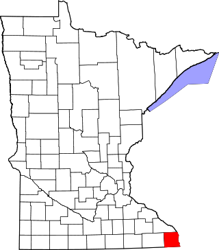
This is a list of the National Register of Historic Places listings in Lake County, Minnesota. It is intended to be a complete list of the properties and districts on the National Register of Historic Places in Lake County, Minnesota, United States. The locations of National Register properties and districts for which the latitude and longitude coordinates are included below, may be seen in an online map.

<span class="mw-page-title-main">National Register of Historic Places listings in Rock County, Minnesota</span>

This is a list of the National Register of Historic Places listings in Rock County, Minnesota. It is intended to be a complete list of the properties and districts on the National Register of Historic Places in Rock County, Minnesota, United States. The locations of National Register properties and districts for which the latitude and longitude coordinates are included below, may be seen in an online map.

<span class="mw-page-title-main">National Register of Historic Places listings in Pipestone County, Minnesota</span>

This is a list of the National Register of Historic Places listings in Pipestone County, Minnesota. It is intended to be a complete list of the properties and districts on the National Register of Historic Places in Pipestone County, Minnesota, United States. The locations of National Register properties and districts for which the latitude and longitude coordinates are included below, may be seen in an online map.

<span class="mw-page-title-main">National Register of Historic Places listings in Houston County, Minnesota</span>

This is a list of the National Register of Historic Places listings in Houston County, Minnesota. It is intended to be a complete list of the properties and districts on the National Register of Historic Places in Houston County, Minnesota, United States. The locations of National Register properties and districts for which the latitude and longitude coordinates are included below, may be seen in an online map.

<span class="mw-page-title-main">National Register of Historic Places listings in Todd County, Minnesota</span>

This is a list of the National Register of Historic Places listings in Todd County, Minnesota. It is intended to be a complete list of the properties and districts on the National Register of Historic Places in Todd County, Minnesota, United States. The locations of National Register properties and districts for which the latitude and longitude coordinates are included below, may be seen in an online map.

<span class="mw-page-title-main">National Register of Historic Places listings in Mille Lacs County, Minnesota</span>

This is a list of the National Register of Historic Places listings in Mille Lacs County, Minnesota.

<span class="mw-page-title-main">National Register of Historic Places listings in Steele County, Minnesota</span>

This is a list of the National Register of Historic Places listings in Steele County, Minnesota. It is intended to be a complete list of the properties and districts on the National Register of Historic Places in Steele County, Minnesota, United States. The locations of National Register properties and districts for which the latitude and longitude coordinates are included below, may be seen in an online map.

<span class="mw-page-title-main">National Register of Historic Places listings in Lyon County, Minnesota</span>

This is a list of the National Register of Historic Places listings in Lyon County, Minnesota. It is intended to be a complete list of the properties and districts on the National Register of Historic Places in Lyon County, Minnesota, United States. The locations of National Register properties and districts for which the latitude and longitude coordinates are included below, may be seen in an online map.

<span class="mw-page-title-main">National Register of Historic Places listings in Meeker County, Minnesota</span>

This is a list of the National Register of Historic Places listings in Meeker County, Minnesota.

<span class="mw-page-title-main">National Register of Historic Places listings in Murray County, Minnesota</span>

This is a list of the National Register of Historic Places listings in Murray County, Minnesota.

<span class="mw-page-title-main">National Register of Historic Places listings in Beltrami County, Minnesota</span>

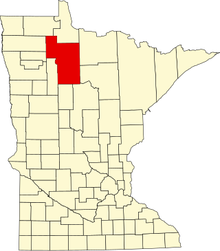
This is a list of the National Register of Historic Places listings in Beltrami County, Minnesota. This is intended to be a complete list of the properties and districts on the National Register of Historic Places in Beltrami County, Minnesota, United States. The locations of National Register properties and districts for which the latitude and longitude coordinates are included below, may be seen in an online map.

<span class="mw-page-title-main">National Register of Historic Places listings in Lac qui Parle County, Minnesota</span>

This is a list of the National Register of Historic Places listings in Lac qui Parle County, Minnesota. It is intended to be a complete list of the properties and districts on the National Register of Historic Places in Lac qui Parle County, Minnesota, United States. The locations of National Register properties and districts for which the latitude and longitude coordinates are included below, may be seen in an online map.

<span class="mw-page-title-main">National Register of Historic Places listings in Mower County, Minnesota</span>

This is a list of the National Register of Historic Places listings in Mower County, Minnesota. It is intended to be a complete list of the properties and districts on the National Register of Historic Places in Mower County, Minnesota, United States. The locations of National Register properties and districts for which the latitude and longitude coordinates are included below, may be seen in an online map.

References

  1. "National Register Information System". National Register of Historic Places . National Park Service. July 9, 2010.