National Register of Historic Places listings in Rock County, Minnesota

Last updated

Location of Rock County in Minnesota Map of Minnesota highlighting Rock County.svg
Location of Rock County in Minnesota

This is a list of the National Register of Historic Places listings in Rock County, Minnesota. It is intended to be a complete list of the properties and districts on the National Register of Historic Places in Rock County, Minnesota, United States. The locations of National Register properties and districts for which the latitude and longitude coordinates are included below, may be seen in an online map.

Contents

There are 20 properties and districts listed on the National Register in the county. A supplementary list includes two additional sites that were formerly on the National Register.


    This National Park Service list is complete through NPS recent listings posted May 10, 2024. [1]

History

Rock County's National Register properties reflect its role as an agricultural region, served by a few population centers connected to eastern markets by railroads. The first and largest community, Luverne, was established in 1867 and platted in 1872, a later start to settlement than most other parts of Minnesota. Rail lines were constructed in the 1870s and 80s, directly influencing the placement of most of the rest of Rock County's towns. [2]

The construction methods of Rock County's listings reveal the changing availability and fashion of building materials. The oldest structures were of wood framing. Increased investment is indicated by the use of brick, in such structures as the 1879 Pierce J. Kniss House and 1880 farmhouse at the Jacob Nuffer Farmstead. Then, from the 1890s to 1905, locally quarried Sioux Quartzite became briefly fashionable, but its extreme hardness soon quashed its appeal among builders. [2]

Current listings

[3] Name on the RegisterImageDate listed [4] Location City or townDescription
1 Blue Mounds State Park WPA/Rustic Style Historic Resources
Blue Mounds State Park WPA/Rustic Style Historic Resources Blue Mounds State Park WPA Dam.jpg
Blue Mounds State Park WPA/Rustic Style Historic Resources
October 25, 1989
(#89001657)
Off U.S. Route 75 north of Luverne
43°43′02″N96°11′21″W / 43.717316°N 96.189205°W / 43.717316; -96.189205 (Blue Mounds State Park WPA/Rustic Style Historic Resources)
Luverne Park facilities with five contributing properties built 1937–42, significant as examples of New Deal federal work relief, regional recreational development, and National Park Service rustic design using Sioux Quartzite. [5]
2 Bridge No. 1482
Bridge No. 1482 Bridge No. 1482.jpg
Bridge No. 1482
June 25, 1992
(#92000775)
Off U.S. Route 75 south of Luverne, Schoneman Park
43°37′30″N96°12′42″W / 43.624873°N 96.211731°W / 43.624873; -96.211731 (Bridge No. 1482)
Luverne Rare Minnesota example of the early and uncommon king post style of steel truss bridge, built in 1908 by the Hewett Bridge Company. Nominated after being moved in 1990 from its original location on the Rock River. [6]
3 Bridge No. L-2162
Bridge No. L-2162 Bridge No. L-2162.jpg
Bridge No. L-2162
November 6, 1989
(#89001839)
County Road 51 over Split Rock Creek
43°46′46″N96°25′56″W / 43.779495°N 96.432114°W / 43.779495; -96.432114 (Bridge No. L-2162)
Jasper Circa-1907 example of an early rural reinforced-concrete arch bridge, of a distinctive vernacular design by prolific local bridge builder Perley N. Gillham. Further notable as Minnesota's longest reinforced concrete bridge built during the first decade of their use. [7]
4 Bridge No. L-2315 November 6, 1989
(#89001841)
Township Road 89 over the Rock River
43°33′21″N96°09′11″W / 43.555924°N 96.152927°W / 43.555924; -96.152927 (Bridge No. L-2315)
Luverne Circa-1901 example of an early rural reinforced-concrete arch bridge, of a distinctive vernacular design by prolific local bridge builder Perley N. Gillham. [8]
5 Bridge No. L-2316 November 6, 1989
(#89001843)
Township Road 89 over the Rock River
43°33′31″N96°09′11″W / 43.558632°N 96.152927°W / 43.558632; -96.152927 (Bridge No. L-2316)
Luverne Circa-1906 example of an early rural reinforced-concrete arch bridge, of a distinctive vernacular design by prolific local bridge builder Perley N. Gillham. [9]
6 Bridge No. L-4646
Bridge No. L-4646 Bridge No. L-4646.jpg
Bridge No. L-4646
November 6, 1989
(#89001844)
6th St. over Spring Brook
43°36′55″N96°21′35″W / 43.615232°N 96.359818°W / 43.615232; -96.359818 (Bridge No. L-4646)
Beaver Creek 1911 example of an early rural reinforced-concrete arch bridge, of a distinctive vernacular design by prolific local bridge builder Perley N. Gillham. [10]
7 First National Bank of Beaver Creek
First National Bank of Beaver Creek First National Bank of Beaver Creek.jpg
First National Bank of Beaver Creek
March 18, 1980
(#80002148)
304 E. 1st Ave.
43°36′50″N96°21′50″W / 43.613957°N 96.363844°W / 43.613957; -96.363844 (First National Bank of Beaver Creek)
Beaver Creek 1917 Classical Revival building with an unusually well-executed design for a small town bank. Also representative of local commercial developments. [11]
8 J.W. Gerber House
J.W. Gerber House J.W. Gerber House.jpg
J.W. Gerber House
March 18, 1980
(#80002151)
324 W. Main St.
43°39′17″N96°12′52″W / 43.654642°N 96.214348°W / 43.654642; -96.214348 (J.W. Gerber House)
Luverne 1901 Colonial Revival house of a successful local businessman and civic leader. Also noted as one of Rock County's finest examples of residential architecture. [12]
9 R.B. Hinkly House
R.B. Hinkly House R.B. Hinkly House.jpg
R.B. Hinkly House
June 10, 1975
(#75001027)
217 N. Freeman Ave.
43°39′22″N96°12′36″W / 43.656006°N 96.209984°W / 43.656006; -96.209984 (R.B. Hinkly House)
Luverne 1892 Queen Anne-styled house notable for its fine Sioux Quartzite construction and prescient incorporation of electrical, plumbing, and telephone amenities. [13] Now a house museum. [14]
10 Holy Trinity Church-Episcopal
Holy Trinity Church-Episcopal Holy Trinity Church Luverne.jpg
Holy Trinity Church-Episcopal
March 18, 1980
(#80002152)
220 N. Cedar St.
43°39′22″N96°12′27″W / 43.656047°N 96.207623°W / 43.656047; -96.207623 (Holy Trinity Church-Episcopal)
Luverne 1891 Gothic Revival church, a center of religious life in early Luverne that is also noted for its fine Sioux Quartzite construction. [15]
11 Jasper Stone Company and Quarry
Jasper Stone Company and Quarry Jasper Stone Company & Quarry.jpg
Jasper Stone Company and Quarry
January 5, 1978
(#78001562)
309 S. Sherman Ave.
43°50′47″N96°23′33″W / 43.846389°N 96.3925°W / 43.846389; -96.3925 (Jasper Stone Company and Quarry)
Jasper Quarry established c. 1890, an early regional source of Sioux Quartzite for construction, and since World War I a leading international producer of silicon dioxide for industrial abrasives. [16]
12 Kenneth School
Kenneth School Kenneth School.jpg
Kenneth School
March 18, 1980
(#80002150)
230 W. 1st Ave.
43°45′15″N96°04′28″W / 43.754196°N 96.074557°W / 43.754196; -96.074557 (Kenneth School)
Kenneth Only remaining example of Rock County's few two-story schools, built in 1901 very soon after Kenneth was founded. [17]
13 Pierce J. Kniss House
Pierce J. Kniss House Pierce J. Kniss House.jpg
Pierce J. Kniss House
March 18, 1980
(#80002153)
209 N. Estey St.
43°39′21″N96°12′43″W / 43.655816°N 96.211889°W / 43.655816; -96.211889 (Pierce J. Kniss House)
Luverne Exemplary Italian Villa style house built 1878–79 by notable local architect George Soutar and builder Joseph H. Jones, owned successively by Luverne co-founder and entrepreneur P.J. Kniss and judge P.E. Brown. [18]
14 Luverne Carnegie Library
Luverne Carnegie Library Luverne Public Library.jpg
Luverne Carnegie Library
March 18, 1980
(#80002154)
205 N. Freeman Ave.
43°39′20″N96°12′36″W / 43.655497°N 96.209928°W / 43.655497; -96.209928 (Luverne Carnegie Library)
Luverne 1904 Carnegie library noted for its role in local education. [19] Now the Carnegie Cultural Center. [20]
15 Frederick and Maryanna Manfred House
Frederick and Maryanna Manfred House Frederick Manfred house.jpg
Frederick and Maryanna Manfred House
June 3, 2022
(#100007790)
1341 141st St. in Blue Mounds State Park
43°41′30″N96°11′45″W / 43.6918°N 96.1959°W / 43.6918; -96.1959 (Frederick and Maryanna Manfred House)
Luverne 1961 house of author Frederick Manfred (1912–1994). Also noted for its exceptional organic architecture, blended into a rocky hill. [21]
16 Maplewood Chapel
Maplewood Chapel Maplewood Chapel.jpg
Maplewood Chapel
March 18, 1980
(#80002155)
1042 W. Warren St.
43°39′15″N96°13′53″W / 43.654125°N 96.231451°W / 43.654125; -96.231451 (Maplewood Chapel)
Luverne Rare example of a cemetery chapel in southwestern Minnesota, built in Gothic Revival style in 1895. [22]
17 Jacob Nuffer Farmstead
Jacob Nuffer Farmstead NufferFarmRockCountyMN.jpg
Jacob Nuffer Farmstead
March 18, 1980
(#80002149)
County Roads 53 and 57
43°33′33″N96°18′53″W / 43.559167°N 96.314722°W / 43.559167; -96.314722 (Jacob Nuffer Farmstead)
Hills Century Farm representing local settlement and agriculture, with five contributing properties built 1880s–1900, including an 1890 farmhouse additionally notable for its fine and locally unusual brick construction. [23]
18 Omaha Depot
Omaha Depot Omaha Depot Luverne.jpg
Omaha Depot
March 18, 1980
(#80002156)
106 E. Fletcher St.
43°39′06″N96°12′33″W / 43.651724°N 96.209035°W / 43.651724; -96.209035 (Omaha Depot)
Luverne 1913 railway station symbolizing the importance of railroads in Rock County's development. [24]
19 Palace Theater
Palace Theater Palace Theater Luverne.jpg
Palace Theater
March 18, 1980
(#80002157)
104 E. Main St.
43°39′15″N96°12′34″W / 43.654029°N 96.209343°W / 43.654029; -96.209343 (Palace Theater)
Luverne 1915 movie theater significant for its elaborate Art Nouveau interior. [25]
20 Rock County Courthouse and Jail
Rock County Courthouse and Jail Rock County Courthouse & Jail.jpg
Rock County Courthouse and Jail
April 18, 1977
(#77000769)
204 E. Brown St.
43°39′24″N96°12′25″W / 43.656777°N 96.207055°W / 43.656777; -96.207055 (Rock County Courthouse and Jail)
Luverne Richardsonian Romanesque government buildings constructed 1887–1890, one of Minnesota's few remaining courthouse and jail complexes. [26]

Former listings

[3] Name on the RegisterImageDate listedDate removedLocation City or townDescription
1 Close Brothers Land Company Tenant House March 18, 1980
(#80002147)
May 7, 1990Co. Hwy. 5
Beaver Creek 1883 house representative of the hundreds of farmsteads developed and sold by a major southwest Minnesota land speculator along railroad land grants. Demolished in 1989 after being damaged by fire. [27]
2 Worthington and Sioux Falls Freight Depot
Worthington and Sioux Falls Freight Depot Worthington and Sioux Falls Freight Depot, Luverne, MN.jpg
Worthington and Sioux Falls Freight Depot
March 18, 1980
(#80002158)
April 26, 1993106 E Fletcher St
Luverne Rock County's first railway station, built in 1876. [2] Demolished in 1992. [28]

See also

Related Research Articles

<span class="mw-page-title-main">National Register of Historic Places listings in Minnesota</span>

This is a list of sites in Minnesota which are included in the National Register of Historic Places. There are more than 1,700 properties and historic districts listed on the NRHP; each of Minnesota's 87 counties has at least 2 listings. Twenty-two sites are also National Historic Landmarks.

<span class="mw-page-title-main">National Register of Historic Places listings in Dakota County, Minnesota</span>

This is a list of the National Register of Historic Places listings in Dakota County, Minnesota. It is intended to be a complete list of the properties and districts on the National Register of Historic Places in Dakota County, Minnesota, United States. Dakota County is located in the southeastern part of the U.S. state of Minnesota, bounded on the northeast side by the Upper Mississippi River and on the northwest by the Minnesota River. The locations of National Register properties and districts for which the latitude and longitude coordinates are included below, may be seen in an online map.

<span class="mw-page-title-main">National Register of Historic Places listings in Rice County, Minnesota</span>

This is a list of the National Register of Historic Places listings in Rice County, Minnesota. It is intended to be a complete list of the properties and districts on the National Register of Historic Places in Rice County, Minnesota, United States. The locations of National Register properties and districts for which the latitude and longitude coordinates are included below, may be seen in an online map.

<span class="mw-page-title-main">National Register of Historic Places listings in Goodhue County, Minnesota</span>

This is a list of the National Register of Historic Places listings in Goodhue County, Minnesota. It is intended to be a complete list of the properties and districts on the National Register of Historic Places in Goodhue County, Minnesota, United States. The locations of National Register properties and districts for which the latitude and longitude coordinates are included below, may be seen in an online map.

<span class="mw-page-title-main">National Register of Historic Places listings in Stearns County, Minnesota</span>

This is a list of the National Register of Historic Places listings in Stearns County, Minnesota. It is intended to be a complete list of the properties and districts on the National Register of Historic Places in Stearns County, Minnesota, United States. The locations of National Register properties and districts for which the latitude and longitude coordinates are included below, may be seen in an online map.

<span class="mw-page-title-main">National Register of Historic Places listings in Morrison County, Minnesota</span>

This is a list of the National Register of Historic Places listings in Morrison County, Minnesota. It is intended to be a complete list of the properties and districts on the National Register of Historic Places in Morrison County, Minnesota, United States. The locations of National Register properties and districts for which the latitude and longitude coordinates are included below, may be seen in an online map.

<span class="mw-page-title-main">National Register of Historic Places listings in Olmsted County, Minnesota</span>

This is a list of the National Register of Historic Places listings in Olmsted County, Minnesota. It is intended to be a complete list of the properties and districts on the National Register of Historic Places in Olmsted County, Minnesota, United States. The locations of National Register properties and districts for which the latitude and longitude coordinates are included below, may be seen in an online map.

<span class="mw-page-title-main">National Register of Historic Places listings in Otter Tail County, Minnesota</span>

This is a list of the National Register of Historic Places listings in Otter Tail County, Minnesota. It is intended to be a complete list of the properties and districts on the National Register of Historic Places in Otter Tail County, Minnesota, United States. The locations of National Register properties and districts for which the latitude and longitude coordinates are included below, may be seen in an online map.

<span class="mw-page-title-main">National Register of Historic Places listings in Pine County, Minnesota</span>

This is a list of the National Register of Historic Places listings in Pine County, Minnesota. It is intended to be a complete list of the properties and districts on the National Register of Historic Places in Pine County, Minnesota, United States. The locations of National Register properties and districts for which the latitude and longitude coordinates are included below, may be seen in an online map.

<span class="mw-page-title-main">National Register of Historic Places listings in Redwood County, Minnesota</span>

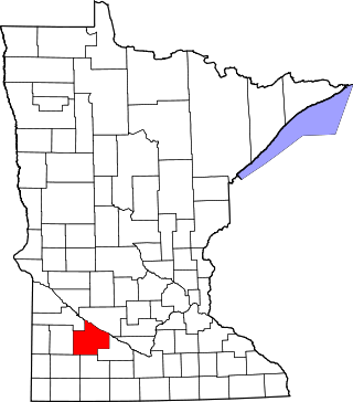
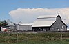
This is a list of the National Register of Historic Places listings in Redwood County, Minnesota. It is intended to be a complete list of the properties and districts on the National Register of Historic Places in Redwood County, Minnesota, United States. The locations of National Register properties and districts for which the latitude and longitude coordinates are included below, may be seen in an online map.

<span class="mw-page-title-main">National Register of Historic Places listings in Fillmore County, Minnesota</span>

This is a list of the National Register of Historic Places listings in Fillmore County, Minnesota. It is intended to be a complete list of the properties and districts on the National Register of Historic Places in Fillmore County, Minnesota, United States. The locations of National Register properties and districts for which the latitude and longitude coordinates are included below, may be seen in an online map.

<span class="mw-page-title-main">National Register of Historic Places listings in Le Sueur County, Minnesota</span>

This is a list of the National Register of Historic Places listings in Le Sueur County, Minnesota. It is intended to be a complete list of the properties and districts on the National Register of Historic Places in Le Sueur County, Minnesota, United States. The locations of National Register properties and districts for which the latitude and longitude coordinates are included below, may be seen in an online map.

<span class="mw-page-title-main">National Register of Historic Places listings in Washington County, Minnesota</span>

This is a list of the National Register of Historic Places listings in Washington County, Minnesota. It is intended to be a complete list of the properties and districts on the National Register of Historic Places in Washington County, Minnesota, United States. The locations of National Register properties and districts for which the latitude and longitude coordinates are included below, may be seen in an online map.

<span class="mw-page-title-main">National Register of Historic Places listings in Lake County, Minnesota</span>

This is a list of the National Register of Historic Places listings in Lake County, Minnesota. It is intended to be a complete list of the properties and districts on the National Register of Historic Places in Lake County, Minnesota, United States. The locations of National Register properties and districts for which the latitude and longitude coordinates are included below, may be seen in an online map.

<span class="mw-page-title-main">National Register of Historic Places listings in Clay County, Minnesota</span>

This is a list of the National Register of Historic Places listings in Clay County, Minnesota. It is intended to be a complete list of the properties and districts on the National Register of Historic Places in Clay County, Minnesota, United States. The locations of National Register properties and districts for which the latitude and longitude coordinates are included below, may be seen in an online map.

<span class="mw-page-title-main">National Register of Historic Places listings in Cook County, Minnesota</span>

This is a list of the National Register of Historic Places listings in Cook County, Minnesota. It is intended to be a complete list of the properties and districts on the National Register of Historic Places in Cook County, Minnesota, United States. The locations of National Register properties and districts for which the latitude and longitude coordinates are included below, may be seen in an online map.

<span class="mw-page-title-main">National Register of Historic Places listings in Douglas County, Minnesota</span>

This is a list of the National Register of Historic Places listings in Douglas County, Minnesota. It is intended to be a complete list of the properties and districts on the National Register of Historic Places in Douglas County, Minnesota, United States. The locations of National Register properties and districts for which the latitude and longitude coordinates are included below, may be seen in an online map.

<span class="mw-page-title-main">National Register of Historic Places listings in Pipestone County, Minnesota</span>

This is a list of the National Register of Historic Places listings in Pipestone County, Minnesota. It is intended to be a complete list of the properties and districts on the National Register of Historic Places in Pipestone County, Minnesota, United States. The locations of National Register properties and districts for which the latitude and longitude coordinates are included below, may be seen in an online map.

<span class="mw-page-title-main">National Register of Historic Places listings in Nobles County, Minnesota</span>

This is a list of the National Register of Historic Places listings in Nobles County, Minnesota. It is intended to be a complete list of the properties and districts on the National Register of Historic Places in Nobles County, Minnesota, United States. The locations of National Register properties and districts for which the latitude and longitude coordinates are included below, may be seen in an online map.

<span class="mw-page-title-main">National Register of Historic Places listings in Martin County, Minnesota</span>

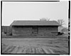
This is a list of the National Register of Historic Places listings in Martin County, Minnesota. It is intended to be a complete list of the properties and districts on the National Register of Historic Places in Martin County, Minnesota, United States. The locations of National Register properties and districts for which the latitude and longitude coordinates are included below, may be seen in an online map.

References

  1. National Park Service, United States Department of the Interior, "National Register of Historic Places: Weekly List Actions", retrieved May 10, 2024.
  2. 1 2 3 Harvey, Thomas (November 1978). "Rock County Multiple Resource Area". United States Department of the Interior Heritage Conservation and Recreation Service. Retrieved 2013-12-12.{{cite journal}}: Cite journal requires |journal= (help)
  3. 1 2 Numbers represent an alphabetical ordering by significant words. Various colorings, defined here, differentiate National Historic Landmarks and historic districts from other NRHP buildings, structures, sites or objects.
  4. The eight-digit number below each date is the number assigned to each location in the National Register Information System database, which can be viewed by clicking the number.
  5. Anderson, Rolf T. (1988-08-31). "National Register of Historic Places Registration Form: Blue Mounds State Park WPA/Rustic Style Historic Resources". National Park Service. Retrieved 2020-04-28.
  6. Roise, Charlene K.; Robert M. Hybben (September 1991). "National Register of Historic Places Registration Form: Bridge No. 1482". National Park Service. Retrieved 2020-04-28.
  7. Frame III, Robert M. (1988-08-15). "National Register of Historic Places Registration Form: Bridge No. L-2162". National Park Service. Retrieved 2020-04-28.
  8. Frame III, Robert M. (1988-08-15). "National Register of Historic Places Registration Form: Bridge No. L-2315". National Park Service. Retrieved 2020-04-28.
  9. Frame III, Robert M. (1988-08-15). "National Register of Historic Places Registration Form: Bridge No. L-2316". National Park Service. Retrieved 2020-04-28.
  10. Frame III, Robert M. (1988-08-15). "National Register of Historic Places Registration Form: Bridge No. L-4646". National Park Service. Retrieved 2020-04-28.
  11. Harvey, Thomas (1978-11-13). "Minnesota Historic Properties Inventory Form: First National Bank Of Beaver Creek". Minnesota Historical Society. Retrieved 2020-04-28.
  12. Harvey, Thomas (1978-11-26). "Minnesota Historic Properties Inventory Form: J.W. Gerber House". Minnesota Historical Society. Retrieved 2020-04-28.
  13. VanBrocklin, Lynne; Charles W. Nelson (1975-03-04). "National Register of Historic Places Inventory -- Nomination Form: Hinkly, R.B., House". National Park Service. Retrieved 2020-04-28.
  14. "Hinkly House". City of Luverne. Retrieved 2013-12-08.
  15. Harvey, Thomas (November 1978). "Minnesota Historic Properties Inventory Form: Holy Trinity Church". Minnesota Historical Society. Retrieved 2020-04-28.
  16. Nelson, Charles W.; Susan Zeik (1976-11-02). "National Register of Historic Places Inventory -- Nomination Form: Jasper Stone Company and Quarry". National Park Service. Retrieved 2020-04-28.
  17. Harvey, Thomas (November 1978). "Minnesota Historic Properties Inventory Form: Kenneth School". Minnesota Historical Society. Retrieved 2020-04-28.
  18. Harvey, Thomas (November 1978). "Minnesota Historic Properties Inventory Form: Kniss House". Minnesota Historical Society. Retrieved 2020-04-28.
  19. Harvey, Thomas (November 1978). "Minnesota Historic Properties Inventory Form: Luverne Library". Minnesota Historical Society. Retrieved 2020-04-28.
  20. "Carnegie Cultural Center". Luverne Area Chamber & CVB. 2008. Retrieved 2013-12-11.
  21. Anderson, Rolf T. (2022-01-31). National Register of Historic Places Registration Form: Frederick and Maryanna Manfred House (PDF). Minnesota State Historic Preservation Office. Retrieved 2022-06-27.
  22. Harvey, Thomas (November 1978). "Minnesota Historic Properties Inventory Form: Maplewood Chapel". Minnesota Historical Society. Retrieved 2020-04-28.
  23. Harvey, Thomas (November 1978). "Minnesota Historic Properties Inventory Form: Nuffer Farmstead". Minnesota Historical Society. Retrieved 2020-04-28.
  24. Harvey, Thomas (November 1978). "Minnesota Historic Properties Inventory Form: Omaha Depot". Minnesota Historical Society. Retrieved 2020-04-28.
  25. Harvey, Thomas (November 1978). "Minnesota Historic Properties Inventory Form: Palace Theater". Minnesota Historical Society. Retrieved 2020-04-28.
  26. Nelson, Charles W.; Susan Zeik (1976-11-02). "National Register of Historic Places Inventory -- Nomination Form: Rock County Courthouse and Jail". National Park Service. Retrieved 2020-04-28.
  27. El-Hai, Jack (2000). Lost Minnesota: Stories of Vanished Places. Minneapolis: University of Minnesota Press. ISBN   0816635153.
  28. Nord, Mary Ann (2003). The National Register of Historic Places in Minnesota: A Guide . St. Paul, Minn.: Minnesota Historical Society Press. ISBN   0-87351-448-3.