
The Humpback Covered Bridge located in the U.S. state of Virginia, is one of the few remaining covered bridges in the United States that was built higher in the middle than on either end; hence the name of "humpback". The bridge was built in 1857 and is also the oldest remaining covered bridge in the state of Virginia. Its WGCB number is 46-03-01. The bridge spans a tributary of the Jackson River known as Dunlap Creek, for a distance of 109 feet (33 m). The humpback feature is 4 feet (1.2 m) higher in the center than at either end. The bridge is located near the city of Covington, Virginia.
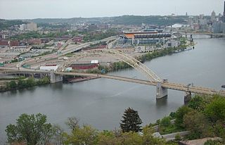
The West End Bridge is a steel tied-arch bridge over the Ohio River in Pittsburgh, Pennsylvania, approximately 1 mile (1.6 km) below the confluence of the Allegheny and Monongahela Rivers. It connects the West End to the Chateau neighborhood on the North Side of Pittsburgh.

The Laughery Creek Bridge is a triple whipple truss bridge on the border of Dearborn County, Indiana, and Ohio County, Indiana. It crosses Laughery Creek. This bridge was built in 1878. The Wrought Iron Bridge Company, a prolific late 19th-century bridge company, constructed the bridge. The bridge is seated on stone abutments. The deck surface is not original and is currently concrete. The bridge, nearly 300 feet in length, is a single span pin connected triple intersection Whipple through truss, and is the only example in the world of this truss type. The name bridge's nickname, "Triple Whipple Bridge" is a play on words. The double-intersection Pratt, which was called the Whipple truss configuration, was a far more common variation of the standard Pratt configuration. Since the Laughery Creek Bridge's members have three intersections instead of two, this gives rise to the "Triple Whipple" name. This bridge was listed on the National Register of Historic Places in 1976.
Pott's Ford Bridge is a bridge 1/2 mile south of Glasco, Kansas, USA that spans the Solomon River in Cloud County, Kansas. It has a wooden deck with three bowstring pony trusses and one Pratt pony truss. The lengths of the trusses are 48 feet (15 m), 46 feet (14 m), and 149 feet (45 m) for the bowstring trusses, and 72 feet (22 m) for the Pratt truss. It was built in 1884 by the Wrought Iron Bridge Company of Canton, Ohio.

The St. Louis-San Francisco Overpass is a pony and deck truss bridge built in 1937 located in Imboden, Lawrence County, Arkansas. It carries U.S. Route 62 and Arkansas Highway 115 over the Spring River for 1,049.9 feet (320.0 m). The bridge has three Pratt deck trusses, each 112 feet (34 m) in length, and three Parker pony trusses, also 112 feet (34 m) long, with the balance of the bridge length in steel girder truss spans. The bridge is 24 feet (7.3 m) wide.

Cartersville Bridge is a historic bridge located near Cartersville, Cumberland County, Virginia. The original bridge was constructed in 1822, and its five stone piers of rough cut ashlar and rubble and two stone abutments remain. Atop them is a superstructure constructed in 1883-84 of heavy timber members with cast-iron connections arranged to form a truss configuration based on the Pratt truss. The bridge is composed of six spans with an end-to-end length of 843 feet (257 m).

The Catoctin Creek Bridge crosses over Catoctin Creek in Loudoun County, Virginia.

The Henninger Farm Covered Bridge, also known as Dauphin County Bridge No. 43, is a historic covered bridge spanning Wiconisco Creek in Washington Township, Dauphin County, Pennsylvania. It was built about 1850, and is a single-span bridge with an overall length of 72 feet. The deck has a width of 16 feet and the clearance is 11 feet. The trussing system is a combination of Burr and Double-arch truss. It is the only remaining covered bridge located wholly in Dauphin County.

The AJX Bridge is a historic Pratt truss bridge in southwestern Johnson County, Wyoming. The bridge was built in 1931 across the South Fork of the Powder River near Kaycee, Wyoming. AJX Bridge was built to provide a river crossing for U.S. Route 87. It was placed on the National Register of Historic Places in 1985 as part of a Multiple Property Submission devoted to historic bridges in Wyoming.

The ECR Kooi Bridge is a bridge in Sheridan County, Wyoming, located 2.7 miles (4.3 km) west of the community of Monarch. The bridge carries Sheridan County Road CN3-93 across the Tongue River. Contractor Jack Gregg built the bridge in 1913. The single-span pin-connected Pratt pony truss bridge is 81.6 feet (24.9 m) long with an 80-foot (24 m) span; it is the longest bridge of its type still in use in the Wyoming state and county highway system. The bridge's roadway was constructed with wooden stringers and decking; its guardrails are also wooden. The pin-connected Pratt pony truss was a common type of truss bridge in Wyoming, and the Kooi Bridge was one of the earlier bridges to use the design.

Gholson Bridge is a historic metal Pratt truss bridge spanning the Meherrin River near Lawrenceville, Brunswick County, Virginia. It was built in 1884 by the Wrought Iron Bridge Company. It consists of two spans. One span is 84 feet (26 m) long and the second is 100 feet 4 inches (30.58 m). It sits on an ashlar sandstone substructure.
Clarkton Bridge was a historic Pratt truss bridge located over the Staunton River near Nathalie, in Charlotte County, Virginia. It was built in 1902 by the Virginia Bridge & Iron Co., and was the only remaining metal truss structure in Virginia built for highway purposes, which was supported by steel cylinder piers. It consisted of two camelback, pin-connected steel through truss channel spans, and twelve steel deck beam approach spans. The overall dimensions of the bridge approach and truss spans were as follows: north approach, 370 feet (110 m) with twelve deck spans; north truss, 150 feet (46 m); south truss, 150 feet (46 m). The total length of the bridge was 692 feet (211 m).

Bowstring Truss Bridge, also known as the Roaring Run Bowstring Truss Bridge and King Tubular Arch Truss Bridge, is a historic bowstring truss bridge located at the Ironto Rest Area near Ironto, Montgomery County, Virginia. It was built by the King Bridge Company in 1878, and is a single-span, four-panel tubular arch pony truss. It measures 55 feet (17 m) long, 12 feet (3.7 m) wide, and 6 feet 6 inches (1.98 m) high with an open roadway width of approximately 9 feet 6 inches (2.90 m). The bridge was partially disassembled and moved from its original location to a second site during the 1930s, where it remained until moved to its current location in 1977.
Bridge over North Fork of Roanoke River was a historic Pratt truss bridge located near Ironto, Montgomery County, Virginia. It was built by the King Bridge Company in 1892, and was a pin-connected through Pratt truss spanning 105 feet (32 m) between cast-in-place concrete abutments. It had ornamental steel lattice portal bracing around the top of the portals. The bridge was removed in 1995–1996, and replaced with new bridge.

Oak Ridge Railroad Overpass is a historic Pratt truss bridge located near Shipman, Nelson County, Virginia. It was built by the Keystone Bridge Company in 1882, and is a single-span, through Pratt truss with two wooden beam approach spans. The span length is 100 feet (30 m). The approach spans are 19 feet (5.8 m) long. It carries VA State Route 653 over the busy Norfolk Southern Washington District, part of the former Southern Main Line between Washington, D.C. and Atlanta.

Nokesville Truss Bridge is a historic Pratt truss bridge spanning the Norfolk Southern Railway near Nokesville, Prince William County, Virginia. It was built in 1882 by the Keystone Bridge Company. The single-span bridge measures 73 feet 11.5 inches (22.543 m) long, and is constructed of wrought iron.

Goshen Land Company Bridge is a historic Pratt through truss bridge spanning the Calfpasture River near Goshen, in Rockbridge County, Virginia, United States. Built in 1890 by the Groton Bridge Company, it consists of two spans, one measuring 138 feet 10 inches (42.32 m) long and the second measuring 120 feet 10 inches (36.83 m); both spans sit at a 30-degree skew.

Linville Creek Bridge is a historic Thacher truss bridge located near Broadway, Rockingham County, Virginia. It was built by the Wrought Iron Bridge Company in 1898. It is a single span, measuring 135 feet 11 inches (41.43 m) long. This bridge was formerly identified as a hybrid Whipple, incorporating aspects of both the double-intersection Pratt and the double-intersection Warren. The structure in actuality is a Thacher truss, a hybrid configuration incorporating elements of the Pratt, Warren, Fink, and Bollman trusses that was first patented by Edwin Thacher in 1883. Its unusual configuration and the bewildering number of descriptions that have been applied to it merely reinforce its position as a bridge that is a rare survivor of an uncommon form.

The Quechee Gorge Bridge is a historic bridge, carrying U.S. Route 4 (US 4) across Quechee Gorge, near the Quechee village of Hartford, Vermont. Built in 1911, it is Vermont's oldest surviving steel arch bridge. It was listed on the National Register of Historic Places in 1990.

The Scenic Bridge crossing Clark Fork River about 4 miles (6.4 km) east of Tarkio in Mineral County, Montana, was built in 1928. It is located at Milepost 0 on Old U.S. Route 10 West. The bridge has also been denoted 24MN304 and MDT No. L31012000+08. It was listed on the National Register of Historic Places in 2010.


